 Note:
The expiration time in the watch graphic is amended if the watch is
replaced, cancelled or extended.
Note:
Note:
The expiration time in the watch graphic is amended if the watch is
replaced, cancelled or extended.
Note: Click for
Watch Status Reports.
SEL2
URGENT - IMMEDIATE BROADCAST REQUESTED
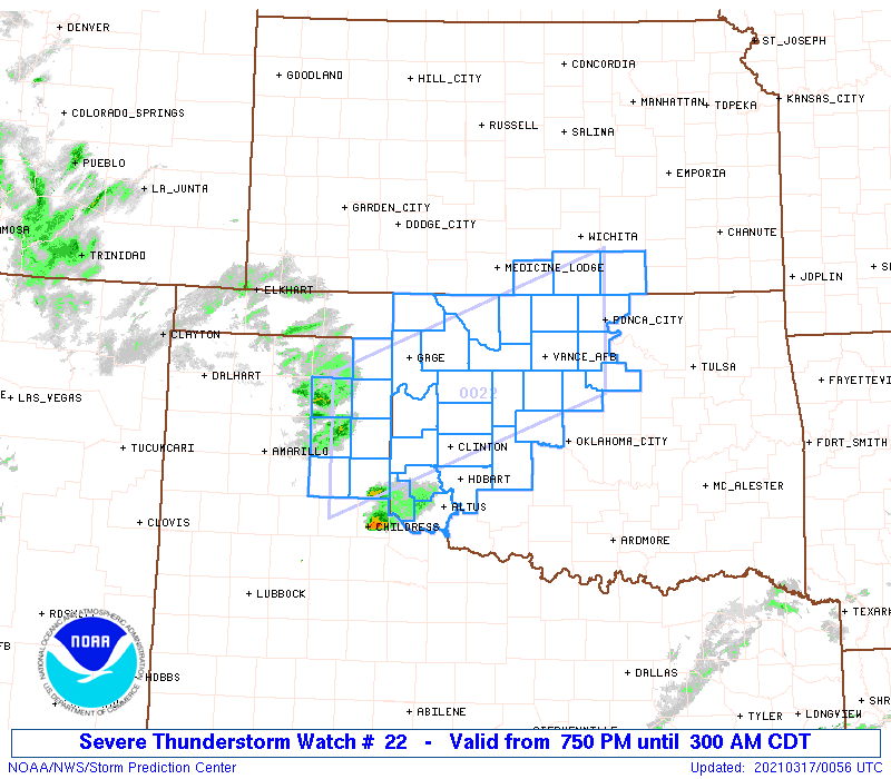
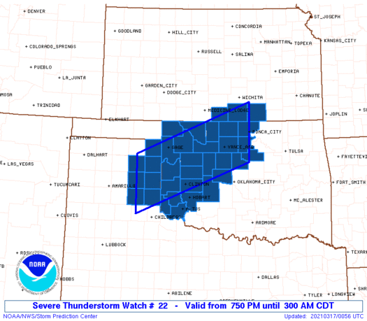
Severe Thunderstorm Watch Number 22
NWS Storm Prediction Center Norman OK
750 PM CDT Tue Mar 16 2021
The NWS Storm Prediction Center has issued a
* Severe Thunderstorm Watch for portions of
South Central Kansas
Western and North-Central Oklahoma
Eastern Texas Panhandle
* Effective this Tuesday night and Wednesday morning from 750 PM
until 300 AM CDT.
* Primary threats include...
Widespread large hail and isolated very large hail events to 3
inches in diameter likely
Scattered damaging wind gusts to 70 mph likely
A tornado or two possible
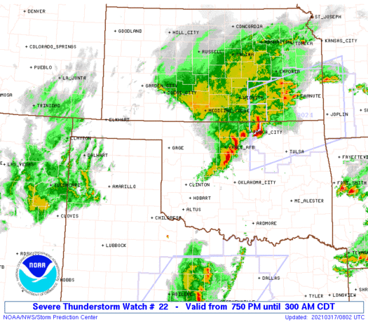
SUMMARY...Thunderstorms are expected to intensify rapidly this
evening along a boundary over northwest Oklahoma and the northeast
Texas Panhandle. Other isolated cells may develop slightly farther
south. Storms will track northeastward across the watch, posing a
risk of very large hail, damaging winds, and perhaps a tornado or
two.
The severe thunderstorm watch area is approximately along and 55
statute miles north and south of a line from 90 miles west of
Clinton OK to Ponca City OK. For a complete depiction of the watch
see the associated watch outline update (WOUS64 KWNS WOU2).
PRECAUTIONARY/PREPAREDNESS ACTIONS...
REMEMBER...A Severe Thunderstorm Watch means conditions are
favorable for severe thunderstorms in and close to the watch area.
Persons in these areas should be on the lookout for threatening
weather conditions and listen for later statements and possible
warnings. Severe thunderstorms can and occasionally do produce
tornadoes.
&&
AVIATION...A few severe thunderstorms with hail surface and aloft to
3 inches. Extreme turbulence and surface wind gusts to 60 knots. A
few cumulonimbi with maximum tops to 450. Mean storm motion vector
24035.
...Hart

   SEL2

   URGENT - IMMEDIATE BROADCAST REQUESTED
   Severe Thunderstorm Watch Number 22
   NWS Storm Prediction Center Norman OK
   750 PM CDT Tue Mar 16 2021

   The NWS Storm Prediction Center has issued a

   * Severe Thunderstorm Watch for portions of
     South Central Kansas
     Western and North-Central Oklahoma
     Eastern Texas Panhandle

   * Effective this Tuesday night and Wednesday morning from 750 PM
     until 300 AM CDT.

   * Primary threats include...
     Widespread large hail and isolated very large hail events to 3
       inches in diameter likely
     Scattered damaging wind gusts to 70 mph likely
     A tornado or two possible

   SUMMARY...Thunderstorms are expected to intensify rapidly this
   evening along a boundary over northwest Oklahoma and the northeast
   Texas Panhandle.  Other isolated cells may develop slightly farther
   south.  Storms will track northeastward across the watch, posing a
   risk of very large hail, damaging winds, and perhaps a tornado or
   two.

   The severe thunderstorm watch area is approximately along and 55
   statute miles north and south of a line from 90 miles west of
   Clinton OK to Ponca City OK. For a complete depiction of the watch
   see the associated watch outline update (WOUS64 KWNS WOU2).

   PRECAUTIONARY/PREPAREDNESS ACTIONS...

   REMEMBER...A Severe Thunderstorm Watch means conditions are
   favorable for severe thunderstorms in and close to the watch area.
   Persons in these areas should be on the lookout for threatening
   weather conditions and listen for later statements and possible
   warnings. Severe thunderstorms can and occasionally do produce
   tornadoes.

   &&

   AVIATION...A few severe thunderstorms with hail surface and aloft to
   3 inches. Extreme turbulence and surface wind gusts to 60 knots. A
   few cumulonimbi with maximum tops to 450. Mean storm motion vector
   24035.

   ...Hart
 Note:
The Aviation Watch (SAW) product is an approximation to the watch area.
The actual watch is depicted by the shaded areas.
Note:
The Aviation Watch (SAW) product is an approximation to the watch area.
The actual watch is depicted by the shaded areas.
   SAW2
   WW 22 SEVERE TSTM KS OK TX 170050Z - 170800Z
   AXIS..55 STATUTE MILES NORTH AND SOUTH OF LINE..
   90W CSM/CLINTON OK/ - PNC/PONCA CITY OK/
   ..AVIATION COORDS.. 50NM N/S /41E AMA - 45ENE END/
   HAIL SURFACE AND ALOFT..3 INCHES. WIND GUSTS..60 KNOTS.
   MAX TOPS TO 450. MEAN STORM MOTION VECTOR 24035.

   LAT...LON 36120080 37529710 35919710 34520080

   THIS IS AN APPROXIMATION TO THE WATCH AREA.  FOR A
   COMPLETE DEPICTION OF THE WATCH SEE WOUS64 KWNS
   FOR WOU2.
Watch 22 Status Report Messages:
STATUS REPORT #4 ON WW 22

VALID 170740Z - 170840Z

SEVERE WEATHER THREAT CONTINUES RIGHT OF A LINE FROM 15 WNW FSI
TO 40 ENE CSM TO 20 WSW END TO 50 WSW CNU.

FOR ADDITIONAL INFORMATION SEE MESOSCALE DISCUSSION 191

..GLEASON..03/17/21

ATTN...WFO...ICT...OUN...AMA...

&&

STATUS REPORT FOR WS 22

SEVERE WEATHER THREAT CONTINUES FOR THE FOLLOWING AREAS

KSC035-170840-

KS
.    KANSAS COUNTIES INCLUDED ARE

COWLEY
$$


OKC011-015-017-047-053-071-073-083-103-119-170840-

OK
.    OKLAHOMA COUNTIES INCLUDED ARE

BLAINE		     CADDO		 CANADIAN
GARFIELD	     GRANT		 KAY
KINGFISHER	     LOGAN		 NOBLE
PAYNE
$$


THE WATCH STATUS MESSAGE IS FOR GUIDANCE PURPOSES ONLY.  PLEASE
REFER TO WATCH COUNTY NOTIFICATION STATEMENTS FOR OFFICIAL
INFORMATION ON COUNTIES...INDEPENDENT CITIES AND MARINE ZONES
CLEARED FROM SEVERE THUNDERSTORM AND TORNADO WATCHES.
$$

STATUS REPORT #3 ON WW 22

VALID 170635Z - 170740Z

SEVERE WEATHER THREAT CONTINUES RIGHT OF A LINE FROM 20 SSW LTS
TO 20 SSW CSM TO 20 NNW CSM TO 50 SW AVK TO 50 S DDC.

..GLEASON..03/17/21

ATTN...WFO...ICT...OUN...AMA...

&&

STATUS REPORT FOR WS 22

SEVERE WEATHER THREAT CONTINUES FOR THE FOLLOWING AREAS

KSC035-077-191-170740-

KS
.    KANSAS COUNTIES INCLUDED ARE

COWLEY		     HARPER		 SUMNER
$$


OKC003-011-015-017-039-043-047-053-059-065-071-073-075-083-093-
103-119-149-151-153-170740-

OK
.    OKLAHOMA COUNTIES INCLUDED ARE

ALFALFA 	     BLAINE		 CADDO
CANADIAN	     CUSTER		 DEWEY
GARFIELD	     GRANT		 HARPER
JACKSON 	     KAY		 KINGFISHER
KIOWA		     LOGAN		 MAJOR
NOBLE		     PAYNE		 WASHITA
WOODS		     WOODWARD
$$


THE WATCH STATUS MESSAGE IS FOR GUIDANCE PURPOSES ONLY.  PLEASE
REFER TO WATCH COUNTY NOTIFICATION STATEMENTS FOR OFFICIAL
INFORMATION ON COUNTIES...INDEPENDENT CITIES AND MARINE ZONES
CLEARED FROM SEVERE THUNDERSTORM AND TORNADO WATCHES.
$$

STATUS REPORT #2 ON WW 22

VALID 170550Z - 170640Z

SEVERE WEATHER THREAT CONTINUES RIGHT OF A LINE FROM 35 ESE CDS
TO 30 NW LTS TO 35 NW CSM TO 55 ESE LBL.

..GLEASON..03/17/21

ATTN...WFO...ICT...OUN...AMA...

&&

STATUS REPORT FOR WS 22

SEVERE WEATHER THREAT CONTINUES FOR THE FOLLOWING AREAS

KSC035-077-191-170640-

KS
.    KANSAS COUNTIES INCLUDED ARE

COWLEY		     HARPER		 SUMNER
$$


OKC003-009-011-015-017-039-043-045-047-053-055-059-065-071-073-
075-083-093-103-119-129-149-151-153-170640-

OK
.    OKLAHOMA COUNTIES INCLUDED ARE

ALFALFA 	     BECKHAM		 BLAINE
CADDO		     CANADIAN		 CUSTER
DEWEY		     ELLIS		 GARFIELD
GRANT		     GREER		 HARPER
JACKSON 	     KAY		 KINGFISHER
KIOWA		     LOGAN		 MAJOR
NOBLE		     PAYNE		 ROGER MILLS
WASHITA 	     WOODS		 WOODWARD
$$


THE WATCH STATUS MESSAGE IS FOR GUIDANCE PURPOSES ONLY.  PLEASE
REFER TO WATCH COUNTY NOTIFICATION STATEMENTS FOR OFFICIAL
INFORMATION ON COUNTIES...INDEPENDENT CITIES AND MARINE ZONES
CLEARED FROM SEVERE THUNDERSTORM AND TORNADO WATCHES.
$$

STATUS REPORT #1 ON WW 22

VALID 170155Z - 170240Z

THE SEVERE WEATHER THREAT CONTINUES ACROSS THE ENTIRE WATCH AREA.

..LYONS..03/17/21

ATTN...WFO...ICT...OUN...AMA...

&&

STATUS REPORT FOR WS 22

SEVERE WEATHER THREAT CONTINUES FOR THE FOLLOWING AREAS

KSC035-077-191-170240-

KS
.    KANSAS COUNTIES INCLUDED ARE

COWLEY		     HARPER		 SUMNER
$$


OKC003-009-011-015-017-039-043-045-047-053-055-057-059-065-071-
073-075-083-093-103-119-129-149-151-153-170240-

OK
.    OKLAHOMA COUNTIES INCLUDED ARE

ALFALFA 	     BECKHAM		 BLAINE
CADDO		     CANADIAN		 CUSTER
DEWEY		     ELLIS		 GARFIELD
GRANT		     GREER		 HARMON
HARPER		     JACKSON		 KAY
KINGFISHER	     KIOWA		 LOGAN
MAJOR		     NOBLE		 PAYNE
ROGER MILLS	     WASHITA		 WOODS
WOODWARD
$$


TXC087-129-179-211-295-393-483-170240-

TX
.    TEXAS COUNTIES INCLUDED ARE

COLLINGSWORTH	     DONLEY		 GRAY
HEMPHILL	     LIPSCOMB		 ROBERTS
WHEELER
$$


THE WATCH STATUS MESSAGE IS FOR GUIDANCE PURPOSES ONLY.  PLEASE
REFER TO WATCH COUNTY NOTIFICATION STATEMENTS FOR OFFICIAL
INFORMATION ON COUNTIES...INDEPENDENT CITIES AND MARINE ZONES
CLEARED FROM SEVERE THUNDERSTORM AND TORNADO WATCHES.
$$
Note:
Click for Complete Product Text.
Tornadoes
Probability of 2 or more tornadoes
|
Low (20%)
|
Probability of 1 or more strong (EF2-EF5) tornadoes
|
Low (10%)
|
Wind
Probability of 10 or more severe wind events
|
High (70%)
|
Probability of 1 or more wind events > 65 knots
|
Low (20%)
|
Hail
Probability of 10 or more severe hail events
|
High (80%)
|
Probability of 1 or more hailstones > 2 inches
|
Mod (60%)
|
Combined Severe Hail/Wind
Probability of 6 or more combined severe hail/wind events
|
High (>95%)
|
For each watch, probabilities for particular events inside the watch
(listed above in each table) are determined by the issuing forecaster.
The "Low" category contains probability values ranging from less than 2%
to 20% (EF2-EF5 tornadoes), less than 5% to 20% (all other probabilities),
"Moderate" from 30% to 60%, and "High" from 70% to greater than 95%.
High values are bolded and lighter in color to provide awareness of
an increased threat for a particular event.


 @NWSSPC