 Note:
The expiration time in the watch graphic is amended if the watch is
replaced, cancelled or extended.
Note:
Note:
The expiration time in the watch graphic is amended if the watch is
replaced, cancelled or extended.
Note: Click for
Watch Status Reports.
SEL3
URGENT - IMMEDIATE BROADCAST REQUESTED
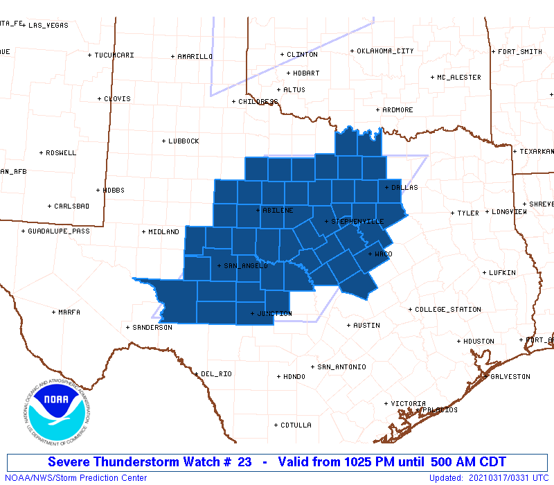
Severe Thunderstorm Watch Number 23
NWS Storm Prediction Center Norman OK
1025 PM CDT Tue Mar 16 2021
The NWS Storm Prediction Center has issued a
* Severe Thunderstorm Watch for portions of
Central and North-Central Texas
* Effective this Tuesday night and Wednesday morning from 1025 PM
until 500 AM CDT.
* Primary threats include...
Scattered damaging wind gusts to 70 mph likely
Scattered large hail and isolated very large hail events to 2
inches in diameter possible
A tornado or two possible
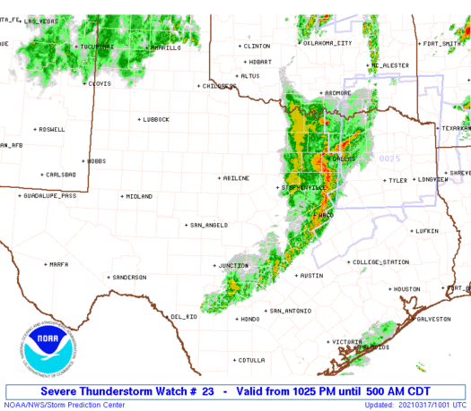
SUMMARY...Thunderstorms are expected to develop and intensify along
a cold front pushing into west Texas. These storms will sweep
eastward overnight across the watch area, posing a risk of damaging
winds and hail. Isolated tornadoes are also possible.
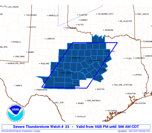
The severe thunderstorm watch area is approximately along and 105
statute miles east and west of a line from 25 miles west southwest
of Junction TX to 50 miles north northeast of Mineral Wells TX. For
a complete depiction of the watch see the associated watch outline
update (WOUS64 KWNS WOU3).
PRECAUTIONARY/PREPAREDNESS ACTIONS...
REMEMBER...A Severe Thunderstorm Watch means conditions are
favorable for severe thunderstorms in and close to the watch area.
Persons in these areas should be on the lookout for threatening
weather conditions and listen for later statements and possible
warnings. Severe thunderstorms can and occasionally do produce
tornadoes.
&&
OTHER WATCH INFORMATION...CONTINUE...WW 22...
AVIATION...A few severe thunderstorms with hail surface and aloft to
2 inches. Extreme turbulence and surface wind gusts to 60 knots. A
few cumulonimbi with maximum tops to 450. Mean storm motion vector
25035.
...Hart
   SEL3

   URGENT - IMMEDIATE BROADCAST REQUESTED
   Severe Thunderstorm Watch Number 23
   NWS Storm Prediction Center Norman OK
   1025 PM CDT Tue Mar 16 2021

   The NWS Storm Prediction Center has issued a

   * Severe Thunderstorm Watch for portions of
     Central and North-Central Texas

   * Effective this Tuesday night and Wednesday morning from 1025 PM
     until 500 AM CDT.

   * Primary threats include...
     Scattered damaging wind gusts to 70 mph likely
     Scattered large hail and isolated very large hail events to 2
       inches in diameter possible
     A tornado or two possible

   SUMMARY...Thunderstorms are expected to develop and intensify along
   a cold front pushing into west Texas.  These storms will sweep
   eastward overnight across the watch area, posing a risk of damaging
   winds and hail.  Isolated tornadoes are also possible.

   The severe thunderstorm watch area is approximately along and 105
   statute miles east and west of a line from 25 miles west southwest
   of Junction TX to 50 miles north northeast of Mineral Wells TX. For
   a complete depiction of the watch see the associated watch outline
   update (WOUS64 KWNS WOU3).

   PRECAUTIONARY/PREPAREDNESS ACTIONS...

   REMEMBER...A Severe Thunderstorm Watch means conditions are
   favorable for severe thunderstorms in and close to the watch area.
   Persons in these areas should be on the lookout for threatening
   weather conditions and listen for later statements and possible
   warnings. Severe thunderstorms can and occasionally do produce
   tornadoes.

   &&

   OTHER WATCH INFORMATION...CONTINUE...WW 22...

   AVIATION...A few severe thunderstorms with hail surface and aloft to
   2 inches. Extreme turbulence and surface wind gusts to 60 knots. A
   few cumulonimbi with maximum tops to 450. Mean storm motion vector
   25035.

   ...Hart
 Note:
The Aviation Watch (SAW) product is an approximation to the watch area.
The actual watch is depicted by the shaded areas.
Note:
The Aviation Watch (SAW) product is an approximation to the watch area.
The actual watch is depicted by the shaded areas.
   SAW3
   WW 23 SEVERE TSTM TX 170325Z - 171000Z
   AXIS..105 STATUTE MILES EAST AND WEST OF LINE..
   25WSW JCT/JUNCTION TX/ - 50NNE MWL/MINERAL WELLS TX/
   ..AVIATION COORDS.. 90NM E/W /22SW JCT - 49NW TTT/
   HAIL SURFACE AND ALOFT..2 INCHES. WIND GUSTS..60 KNOTS.
   MAX TOPS TO 450. MEAN STORM MOTION VECTOR 25035.

   LAT...LON 30370192 33439956 33439592 30379840

   THIS IS AN APPROXIMATION TO THE WATCH AREA.  FOR A
   COMPLETE DEPICTION OF THE WATCH SEE WOUS64 KWNS
   FOR WOU3.
Watch 23 Status Report Messages:
STATUS REPORT #5 ON WW 23

VALID 170945Z - 171040Z

SEVERE WEATHER THREAT CONTINUES RIGHT OF A LINE FROM 40 WSW TPL
TO 20 WSW ACT TO 35 N ACT TO 25 SSW FTW TO 20 SSW ADM.

..GLEASON..03/17/21

ATTN...WFO...FWD...SJT...

&&

STATUS REPORT FOR WS 23

SEVERE WEATHER THREAT CONTINUES FOR THE FOLLOWING AREAS

TXC027-097-099-113-121-139-217-251-309-439-171040-

TX
.    TEXAS COUNTIES INCLUDED ARE

BELL		     COOKE		 CORYELL
DALLAS		     DENTON		 ELLIS
HILL		     JOHNSON		 MCLENNAN
TARRANT
$$


THE WATCH STATUS MESSAGE IS FOR GUIDANCE PURPOSES ONLY.  PLEASE
REFER TO WATCH COUNTY NOTIFICATION STATEMENTS FOR OFFICIAL
INFORMATION ON COUNTIES...INDEPENDENT CITIES AND MARINE ZONES
CLEARED FROM SEVERE THUNDERSTORM AND TORNADO WATCHES.
$$

STATUS REPORT #4 ON WW 23

VALID 170830Z - 170940Z

SEVERE WEATHER THREAT CONTINUES RIGHT OF A LINE FROM 35 WSW JCT
TO 25 ENE JCT TO 45 S BWD TO 30 SSW SEP TO 25 NW SEP TO 35 SE SPS.

..GLEASON..03/17/21

ATTN...WFO...FWD...SJT...

&&

STATUS REPORT FOR WS 23

SEVERE WEATHER THREAT CONTINUES FOR THE FOLLOWING AREAS

TXC027-035-093-097-099-113-121-139-143-193-217-221-237-251-267-
281-309-319-333-337-363-367-411-425-439-497-170940-

TX
.    TEXAS COUNTIES INCLUDED ARE

BELL		     BOSQUE		 COMANCHE
COOKE		     CORYELL		 DALLAS
DENTON		     ELLIS		 ERATH
HAMILTON	     HILL		 HOOD
JACK		     JOHNSON		 KIMBLE
LAMPASAS	     MCLENNAN		 MASON
MILLS		     MONTAGUE		 PALO PINTO
PARKER		     SAN SABA		 SOMERVELL
TARRANT 	     WISE
$$


THE WATCH STATUS MESSAGE IS FOR GUIDANCE PURPOSES ONLY.  PLEASE
REFER TO WATCH COUNTY NOTIFICATION STATEMENTS FOR OFFICIAL
INFORMATION ON COUNTIES...INDEPENDENT CITIES AND MARINE ZONES
CLEARED FROM SEVERE THUNDERSTORM AND TORNADO WATCHES.
$$

STATUS REPORT #3 ON WW 23

VALID 170745Z - 170840Z

SEVERE WEATHER THREAT CONTINUES RIGHT OF A LINE FROM 60 ENE 6R6
TO 25 NNW JCT TO 30 SSW BWD TO 10 W BWD TO 35 E ABI TO 30 SW SPS.

FOR ADDITIONAL INFORMATION SEE MESOSCALE DISCUSSION 192

..GLEASON..03/17/21

ATTN...WFO...FWD...SJT...

&&

STATUS REPORT FOR WS 23

SEVERE WEATHER THREAT CONTINUES FOR THE FOLLOWING AREAS

TXC027-035-049-093-097-099-113-121-133-139-143-193-217-221-237-
251-267-281-307-309-319-327-333-337-363-367-411-425-429-435-439-
497-503-170840-

TX
.    TEXAS COUNTIES INCLUDED ARE

BELL		     BOSQUE		 BROWN
COMANCHE	     COOKE		 CORYELL
DALLAS		     DENTON		 EASTLAND
ELLIS		     ERATH		 HAMILTON
HILL		     HOOD		 JACK
JOHNSON 	     KIMBLE		 LAMPASAS
MCCULLOCH	     MCLENNAN		 MASON
MENARD		     MILLS		 MONTAGUE
PALO PINTO	     PARKER		 SAN SABA
SOMERVELL	     STEPHENS		 SUTTON
TARRANT 	     WISE		 YOUNG
$$


THE WATCH STATUS MESSAGE IS FOR GUIDANCE PURPOSES ONLY.  PLEASE
REFER TO WATCH COUNTY NOTIFICATION STATEMENTS FOR OFFICIAL
INFORMATION ON COUNTIES...INDEPENDENT CITIES AND MARINE ZONES
CLEARED FROM SEVERE THUNDERSTORM AND TORNADO WATCHES.
$$

STATUS REPORT #2 ON WW 23

VALID 170640Z - 170740Z

SEVERE WEATHER THREAT CONTINUES RIGHT OF A LINE FROM 25 NNE 6R6
TO 15 E SJT TO 20 WSW ABI TO 70 NNW ABI.

..GLEASON..03/17/21

ATTN...WFO...FWD...SJT...

&&

STATUS REPORT FOR WS 23

SEVERE WEATHER THREAT CONTINUES FOR THE FOLLOWING AREAS

TXC027-035-049-059-083-093-095-097-099-105-113-121-133-139-143-
193-207-217-221-237-251-253-267-281-307-309-319-327-333-337-363-
367-399-411-413-417-425-429-435-439-441-447-451-497-503-
170740-

TX
.    TEXAS COUNTIES INCLUDED ARE

BELL		     BOSQUE		 BROWN
CALLAHAN	     COLEMAN		 COMANCHE
CONCHO		     COOKE		 CORYELL
CROCKETT	     DALLAS		 DENTON
EASTLAND	     ELLIS		 ERATH
HAMILTON	     HASKELL		 HILL
HOOD		     JACK		 JOHNSON
JONES		     KIMBLE		 LAMPASAS
MCCULLOCH	     MCLENNAN		 MASON
MENARD		     MILLS		 MONTAGUE
PALO PINTO	     PARKER		 RUNNELS
SAN SABA	     SCHLEICHER 	 SHACKELFORD
SOMERVELL	     STEPHENS		 SUTTON
TARRANT 	     TAYLOR		 THROCKMORTON
TOM GREEN	     WISE		 YOUNG
$$


THE WATCH STATUS MESSAGE IS FOR GUIDANCE PURPOSES ONLY.  PLEASE
REFER TO WATCH COUNTY NOTIFICATION STATEMENTS FOR OFFICIAL
INFORMATION ON COUNTIES...INDEPENDENT CITIES AND MARINE ZONES
CLEARED FROM SEVERE THUNDERSTORM AND TORNADO WATCHES.
$$

STATUS REPORT #1 ON WW 23

VALID 170550Z - 170640Z

SEVERE WEATHER THREAT CONTINUES RIGHT OF A LINE FROM 55 NNE 6R6
TO 25 WNW SJT TO 55 NNW ABI.

..GLEASON..03/17/21

ATTN...WFO...FWD...SJT...

&&

STATUS REPORT FOR WS 23

SEVERE WEATHER THREAT CONTINUES FOR THE FOLLOWING AREAS

TXC027-035-049-059-081-083-093-095-097-099-105-113-121-133-139-
143-151-193-207-217-221-235-237-251-253-267-281-307-309-319-327-
333-337-353-363-367-399-411-413-417-425-429-435-439-441-447-451-
497-503-170640-

TX
.    TEXAS COUNTIES INCLUDED ARE

BELL		     BOSQUE		 BROWN
CALLAHAN	     COKE		 COLEMAN
COMANCHE	     CONCHO		 COOKE
CORYELL 	     CROCKETT		 DALLAS
DENTON		     EASTLAND		 ELLIS
ERATH		     FISHER		 HAMILTON
HASKELL 	     HILL		 HOOD
IRION		     JACK		 JOHNSON
JONES		     KIMBLE		 LAMPASAS
MCCULLOCH	     MCLENNAN		 MASON
MENARD		     MILLS		 MONTAGUE
NOLAN		     PALO PINTO 	 PARKER
RUNNELS 	     SAN SABA		 SCHLEICHER
SHACKELFORD	     SOMERVELL		 STEPHENS
SUTTON		     TARRANT		 TAYLOR
THROCKMORTON	     TOM GREEN		 WISE
YOUNG
$$


THE WATCH STATUS MESSAGE IS FOR GUIDANCE PURPOSES ONLY.  PLEASE
REFER TO WATCH COUNTY NOTIFICATION STATEMENTS FOR OFFICIAL
INFORMATION ON COUNTIES...INDEPENDENT CITIES AND MARINE ZONES
CLEARED FROM SEVERE THUNDERSTORM AND TORNADO WATCHES.
$$
Note:
Click for Complete Product Text.
Tornadoes
Probability of 2 or more tornadoes
|
Low (20%)
|
Probability of 1 or more strong (EF2-EF5) tornadoes
|
Low (5%)
|
Wind
Probability of 10 or more severe wind events
|
Mod (60%)
|
Probability of 1 or more wind events > 65 knots
|
Low (20%)
|
Hail
Probability of 10 or more severe hail events
|
Mod (40%)
|
Probability of 1 or more hailstones > 2 inches
|
Mod (40%)
|
Combined Severe Hail/Wind
Probability of 6 or more combined severe hail/wind events
|
High (90%)
|
For each watch, probabilities for particular events inside the watch
(listed above in each table) are determined by the issuing forecaster.
The "Low" category contains probability values ranging from less than 2%
to 20% (EF2-EF5 tornadoes), less than 5% to 20% (all other probabilities),
"Moderate" from 30% to 60%, and "High" from 70% to greater than 95%.
High values are bolded and lighter in color to provide awareness of
an increased threat for a particular event.


 @NWSSPC