Note:
The expiration time in the watch graphic is amended if the watch is
replaced, cancelled or extended.
Note:
Note:
The expiration time in the watch graphic is amended if the watch is
replaced, cancelled or extended.
Note: Click for
Watch Status Reports.
SEL0
URGENT - IMMEDIATE BROADCAST REQUESTED
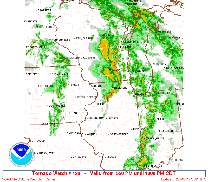
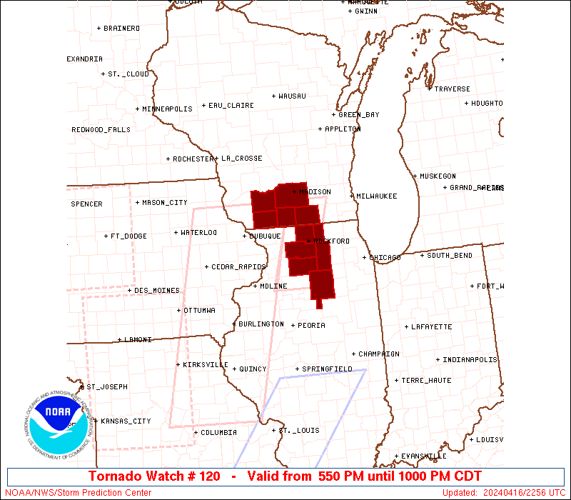
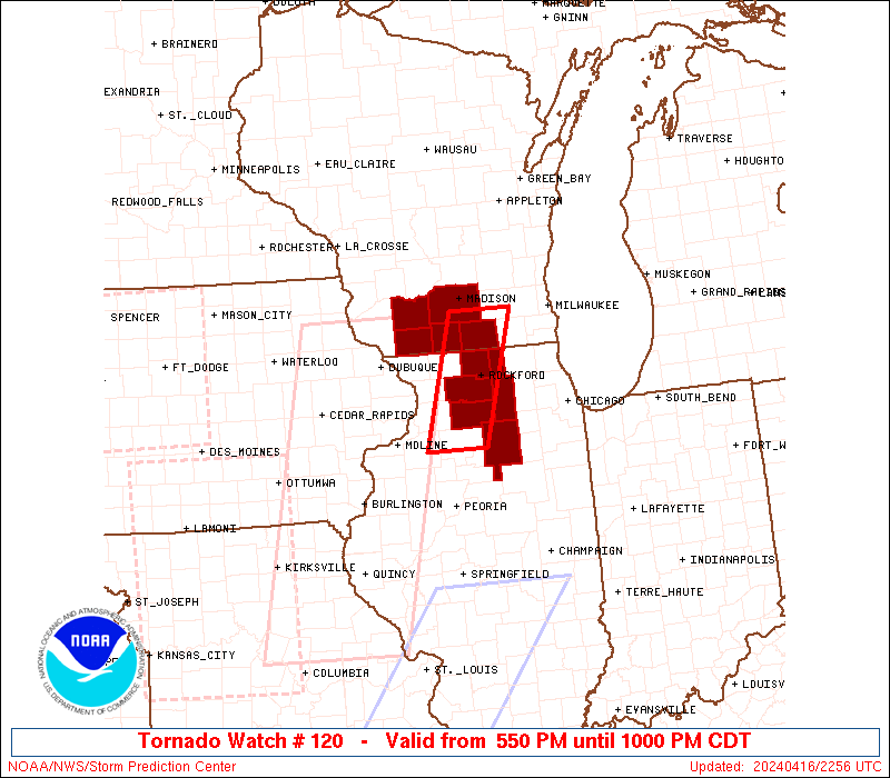
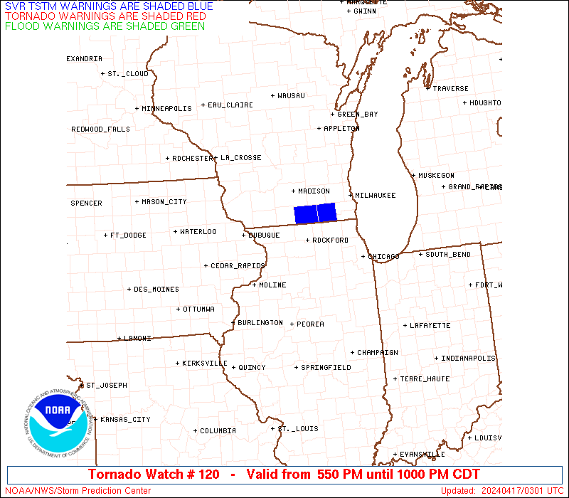
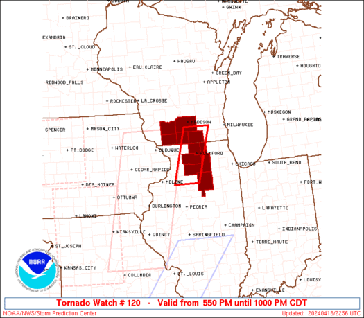
Tornado Watch Number 120
NWS Storm Prediction Center Norman OK
550 PM CDT Tue Apr 16 2024
The NWS Storm Prediction Center has issued a
* Tornado Watch for portions of
Northern Illinois
Southern Wisconsin
* Effective this Tuesday afternoon and evening from 550 PM until
1000 PM CDT.
* Primary threats include...
A couple tornadoes possible
Scattered damaging wind gusts to 70 mph possible
Scattered large hail events to 1.5 inches in diameter possible
SUMMARY...Scattered storm clusters and a couple of supercells will
be possible this evening into north central Illinois and south
central Wisconsin near a surface warm front. A couple of tornadoes,
damaging gusts of 60-70 mph and large hail of 1-1.5 inches in
diameter will all be possible through late evening.
The tornado watch area is approximately along and 25 statute miles
east and west of a line from 25 miles north of Janesville WI to 65
miles south southwest of Rockford IL. For a complete depiction of
the watch see the associated watch outline update (WOUS64 KWNS
WOU0).
PRECAUTIONARY/PREPAREDNESS ACTIONS...
REMEMBER...A Tornado Watch means conditions are favorable for
tornadoes and severe thunderstorms in and close to the watch
area. Persons in these areas should be on the lookout for
threatening weather conditions and listen for later statements
and possible warnings.
&&
OTHER WATCH INFORMATION...CONTINUE...WW 116...WW 117...WW
118...WW 119...
AVIATION...Tornadoes and a few severe thunderstorms with hail
surface and aloft to 1.5 inches. Extreme turbulence and surface wind
gusts to 60 knots. A few cumulonimbi with maximum tops to 500. Mean
storm motion vector 23035.
...Thompson

   SEL0

   URGENT - IMMEDIATE BROADCAST REQUESTED
   Tornado Watch Number 120
   NWS Storm Prediction Center Norman OK
   550 PM CDT Tue Apr 16 2024

   The NWS Storm Prediction Center has issued a

   * Tornado Watch for portions of
     Northern Illinois
     Southern Wisconsin

   * Effective this Tuesday afternoon and evening from 550 PM until
     1000 PM CDT.

   * Primary threats include...
     A couple tornadoes possible
     Scattered damaging wind gusts to 70 mph possible
     Scattered large hail events to 1.5 inches in diameter possible

   SUMMARY...Scattered storm clusters and a couple of supercells will
   be possible this evening into north central Illinois and south
   central Wisconsin near a surface warm front.  A couple of tornadoes,
   damaging gusts of 60-70 mph and large hail of 1-1.5 inches in
   diameter will all be possible through late evening.

   The tornado watch area is approximately along and 25 statute miles
   east and west of a line from 25 miles north of Janesville WI to 65
   miles south southwest of Rockford IL. For a complete depiction of
   the watch see the associated watch outline update (WOUS64 KWNS
   WOU0).

   PRECAUTIONARY/PREPAREDNESS ACTIONS...

   REMEMBER...A Tornado Watch means conditions are favorable for
   tornadoes and severe thunderstorms in and close to the watch
   area. Persons in these areas should be on the lookout for
   threatening weather conditions and listen for later statements
   and possible warnings.

   &&

   OTHER WATCH INFORMATION...CONTINUE...WW 116...WW 117...WW
   118...WW 119...

   AVIATION...Tornadoes and a few severe thunderstorms with hail
   surface and aloft to 1.5 inches. Extreme turbulence and surface wind
   gusts to 60 knots. A few cumulonimbi with maximum tops to 500. Mean
   storm motion vector 23035.

   ...Thompson
 Note:
The Aviation Watch (SAW) product is an approximation to the watch area.
The actual watch is depicted by the shaded areas.
Note:
The Aviation Watch (SAW) product is an approximation to the watch area.
The actual watch is depicted by the shaded areas.
   SAW0
   WW 120 TORNADO IL WI 162250Z - 170300Z
   AXIS..25 STATUTE MILES EAST AND WEST OF LINE..
   25N JVL/JANESVILLE WI/ - 65SSW RFD/ROCKFORD IL/
   ..AVIATION COORDS.. 20NM E/W /34WSW BAE - 10N BDF/
   HAIL SURFACE AND ALOFT..1.5 INCHES. WIND GUSTS..60 KNOTS.
   MAX TOPS TO 500. MEAN STORM MOTION VECTOR 23035.

   LAT...LON 42988854 41338910 41339006 42988952

   THIS IS AN APPROXIMATION TO THE WATCH AREA.  FOR A
   COMPLETE DEPICTION OF THE WATCH SEE WOUS64 KWNS
   FOR WOU0.
Watch 120 Status Report Messages:
STATUS REPORT #6 ON WW 120

VALID 170245Z - 170300Z

SEVERE WEATHER THREAT CONTINUES RIGHT OF A LINE FROM 25 ESE MLI
TO 25 SW RFD TO 10 N RFD TO 10 SE MSN.

REMAINING VALID PORTION OF WW 120 MAY BE ALLOWED TO EXPIRE AT
17/03Z.
..KERR..04/17/24

ATTN...WFO...LOT...MKX...

&&

STATUS REPORT FOR WT 120

SEVERE WEATHER THREAT CONTINUES FOR THE FOLLOWING AREAS

ILC007-037-099-103-141-201-170300-

IL
.    ILLINOIS COUNTIES INCLUDED ARE

BOONE		     DE KALB		 LA SALLE
LEE		     OGLE		 WINNEBAGO
$$


WIC055-105-127-170300-

WI
.    WISCONSIN COUNTIES INCLUDED ARE

JEFFERSON	     ROCK		 WALWORTH
$$


THE WATCH STATUS MESSAGE IS FOR GUIDANCE PURPOSES ONLY.  PLEASE
REFER TO WATCH COUNTY NOTIFICATION STATEMENTS FOR OFFICIAL
INFORMATION ON COUNTIES...INDEPENDENT CITIES AND MARINE ZONES
CLEARED FROM SEVERE THUNDERSTORM AND TORNADO WATCHES.
$$

STATUS REPORT #5 ON WW 120

VALID 170245Z - 170300Z

SEVERE WEATHER THREAT CONTINUES RIGHT OF A LINE FROM 25 ESE MLI
TO 25 SW RFD TO 10 N RFD TO 10 SE MSN.

REMAINING VALID PORTION OF WW 120 MAY BE ALLOWED TO EXPIRE AT
17/03Z.
..KERR..04/17/24

ATTN...WFO...LOT...MKX...

&&

STATUS REPORT FOR WT 120

SEVERE WEATHER THREAT CONTINUES FOR THE FOLLOWING AREAS

ILC007-037-099-103-141-201-170300-

IL
.    ILLINOIS COUNTIES INCLUDED ARE

BOONE		     DE KALB		 LA SALLE
LEE		     OGLE		 WINNEBAGO
$$


WIC055-105-127-170300-

WI
.    WISCONSIN COUNTIES INCLUDED ARE

JEFFERSON	     ROCK		 WALWORTH
$$


THE WATCH STATUS MESSAGE IS FOR GUIDANCE PURPOSES ONLY.  PLEASE
REFER TO WATCH COUNTY NOTIFICATION STATEMENTS FOR OFFICIAL
INFORMATION ON COUNTIES...INDEPENDENT CITIES AND MARINE ZONES
CLEARED FROM SEVERE THUNDERSTORM AND TORNADO WATCHES.
$$

STATUS REPORT #4 ON WW 120

VALID 170235Z - 170300Z

SEVERE WEATHER THREAT CONTINUES RIGHT OF A LINE FROM 25 ESE MLI
TO 45 ENE MLI TO 20 SW RFD TO 10 N RFD TO 10 SSE MSN.

REMAINING VALID PORTION OF WW 120 MAY BE ALLOWED TO EXPIRE AT
17/03Z.
..KERR..04/17/24

ATTN...WFO...LOT...MKX...

&&

STATUS REPORT FOR WT 120

SEVERE WEATHER THREAT CONTINUES FOR THE FOLLOWING AREAS

ILC007-037-099-103-141-201-170300-

IL
.    ILLINOIS COUNTIES INCLUDED ARE

BOONE		     DE KALB		 LA SALLE
LEE		     OGLE		 WINNEBAGO
$$


WIC055-105-127-170300-

WI
.    WISCONSIN COUNTIES INCLUDED ARE

JEFFERSON	     ROCK		 WALWORTH
$$


THE WATCH STATUS MESSAGE IS FOR GUIDANCE PURPOSES ONLY.  PLEASE
REFER TO WATCH COUNTY NOTIFICATION STATEMENTS FOR OFFICIAL
INFORMATION ON COUNTIES...INDEPENDENT CITIES AND MARINE ZONES
CLEARED FROM SEVERE THUNDERSTORM AND TORNADO WATCHES.
$$

STATUS REPORT #3 ON WW 120

VALID 170235Z - 170300Z

SEVERE WEATHER THREAT CONTINUES RIGHT OF A LINE FROM 25 ESE MLI
TO 45 ENE MLI TO 20 SW RFD TO 10 N RFD TO 10 SSE MSN.

REMAINING VALID PORTION OF WW 120 MAY BE ALLOWED TO EXPIRE AT
17/03Z.
..KERR..04/17/24

ATTN...WFO...LOT...MKX...

&&

STATUS REPORT FOR WT 120

SEVERE WEATHER THREAT CONTINUES FOR THE FOLLOWING AREAS

ILC007-037-099-103-141-201-170300-

IL
.    ILLINOIS COUNTIES INCLUDED ARE

BOONE		     DE KALB		 LA SALLE
LEE		     OGLE		 WINNEBAGO
$$


WIC055-105-127-170300-

WI
.    WISCONSIN COUNTIES INCLUDED ARE

JEFFERSON	     ROCK		 WALWORTH
$$


THE WATCH STATUS MESSAGE IS FOR GUIDANCE PURPOSES ONLY.  PLEASE
REFER TO WATCH COUNTY NOTIFICATION STATEMENTS FOR OFFICIAL
INFORMATION ON COUNTIES...INDEPENDENT CITIES AND MARINE ZONES
CLEARED FROM SEVERE THUNDERSTORM AND TORNADO WATCHES.
$$

STATUS REPORT #2 ON WW 120

VALID 170150Z - 170240Z

SEVERE WEATHER THREAT CONTINUES RIGHT OF A LINE FROM 40 ESE DBQ
TO 15 WSW MSN TO 20 NW MSN.

..LYONS..04/17/24

ATTN...WFO...LOT...MKX...

&&

STATUS REPORT FOR WT 120

SEVERE WEATHER THREAT CONTINUES FOR THE FOLLOWING AREAS

ILC007-037-099-103-141-201-170240-

IL
.    ILLINOIS COUNTIES INCLUDED ARE

BOONE		     DE KALB		 LA SALLE
LEE		     OGLE		 WINNEBAGO
$$


WIC025-045-105-170240-

WI
.    WISCONSIN COUNTIES INCLUDED ARE

DANE		     GREEN		 ROCK
$$


THE WATCH STATUS MESSAGE IS FOR GUIDANCE PURPOSES ONLY.  PLEASE
REFER TO WATCH COUNTY NOTIFICATION STATEMENTS FOR OFFICIAL
INFORMATION ON COUNTIES...INDEPENDENT CITIES AND MARINE ZONES
CLEARED FROM SEVERE THUNDERSTORM AND TORNADO WATCHES.
$$

STATUS REPORT #1 ON WW 120

VALID 162340Z - 170040Z

THE SEVERE WEATHER THREAT CONTINUES ACROSS THE ENTIRE WATCH AREA.

..LYONS..04/16/24

ATTN...WFO...LOT...MKX...

&&

STATUS REPORT FOR WT 120

SEVERE WEATHER THREAT CONTINUES FOR THE FOLLOWING AREAS

ILC007-037-099-103-141-201-170040-

IL
.    ILLINOIS COUNTIES INCLUDED ARE

BOONE		     DE KALB		 LA SALLE
LEE		     OGLE		 WINNEBAGO
$$


WIC025-045-049-065-105-170040-

WI
.    WISCONSIN COUNTIES INCLUDED ARE

DANE		     GREEN		 IOWA
LAFAYETTE	     ROCK
$$


THE WATCH STATUS MESSAGE IS FOR GUIDANCE PURPOSES ONLY.  PLEASE
REFER TO WATCH COUNTY NOTIFICATION STATEMENTS FOR OFFICIAL
INFORMATION ON COUNTIES...INDEPENDENT CITIES AND MARINE ZONES
CLEARED FROM SEVERE THUNDERSTORM AND TORNADO WATCHES.
$$
Note:
Click for Complete Product Text.
Tornadoes
Probability of 2 or more tornadoes
|
Mod (40%)
|
Probability of 1 or more strong (EF2-EF5) tornadoes
|
Low (20%)
|
Wind
Probability of 10 or more severe wind events
|
Mod (40%)
|
Probability of 1 or more wind events > 65 knots
|
Low (20%)
|
Hail
Probability of 10 or more severe hail events
|
Mod (40%)
|
Probability of 1 or more hailstones > 2 inches
|
Low (20%)
|
Combined Severe Hail/Wind
Probability of 6 or more combined severe hail/wind events
|
High (70%)
|
For each watch, probabilities for particular events inside the watch
(listed above in each table) are determined by the issuing forecaster.
The "Low" category contains probability values ranging from less than 2%
to 20% (EF2-EF5 tornadoes), less than 5% to 20% (all other probabilities),
"Moderate" from 30% to 60%, and "High" from 70% to greater than 95%.
High values are bolded and lighter in color to provide awareness of
an increased threat for a particular event.


 @NWSSPC