|
| Mesoscale Discussion 468 |
|
< Previous MD Next MD >
|
|
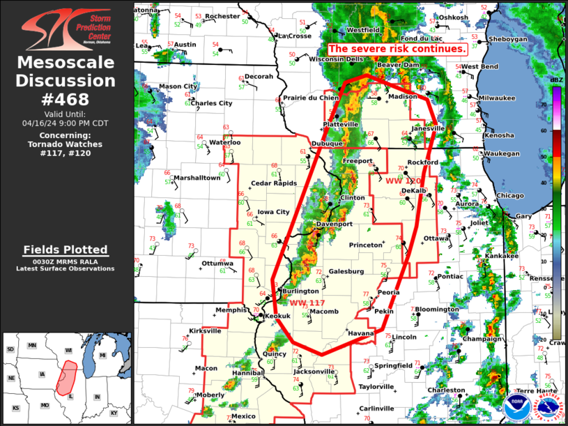
   Mesoscale Discussion 0468
   NWS Storm Prediction Center Norman OK
   0732 PM CDT Tue Apr 16 2024

   Areas affected...pats of far eastern Iowa...central/northern
   Illinois...and far southern Wisconsin

   Concerning...Tornado Watch 117...120...

   Valid 170032Z - 170200Z

   The severe weather threat for Tornado Watch 117, 120 continues.

   SUMMARY...The risk for damaging winds, hail, and a couple of
   tornadoes continues. Local extensions of WW117 may be needed across
   parts of IL this evening.

   DISCUSSION...The ongoing cluster of thunderstorms over eastern IA is
   expected to move into western IL and southern WI in the next hour.
   Buoyancy generally decreases with north/eastward extent as previous
   convection has overturned the air mass south of the nearly
   stationary warm front. Still, 500-1000 J/kg of MLCAPE and strong
   deep-layer shear will allow storms to stay organized farther east
   into IL early this evening. Damaging winds appear to be the most
   likely threat given the linear mode, but hail and a couple of
   tornadoes will remain possible. Strong to severe storms may linger
   over parts of far southeast IA and into western/central IL after the
   planned 01z expiration of WW118. Convective trends will be monitored
   and a local extension could be necessary.

   ..Lyons/Thompson.. 04/17/2024

   ...Please see www.spc.noaa.gov for graphic product...

   ATTN...WFO...LOT...ILX...MKX...LSX...DVN...ARX...

   LAT...LON   39999044 40139091 40449118 40909124 42679041 43309008
               43388972 43248926 43098872 42778858 42208880 41548893
               41218906 40298949 39999044
|
|
Top/All Mesoscale Discussions/Forecast Products/Home
|
|


 @NWSSPC