Note:
The expiration time in the watch graphic is amended if the watch is
replaced, cancelled or extended.
Note:
Note:
The expiration time in the watch graphic is amended if the watch is
replaced, cancelled or extended.
Note: Click for
Watch Status Reports.
SEL1
URGENT - IMMEDIATE BROADCAST REQUESTED
Severe Thunderstorm Watch Number 121
NWS Storm Prediction Center Norman OK
1150 AM EDT Wed Apr 17 2024
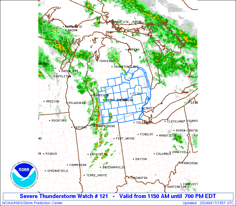
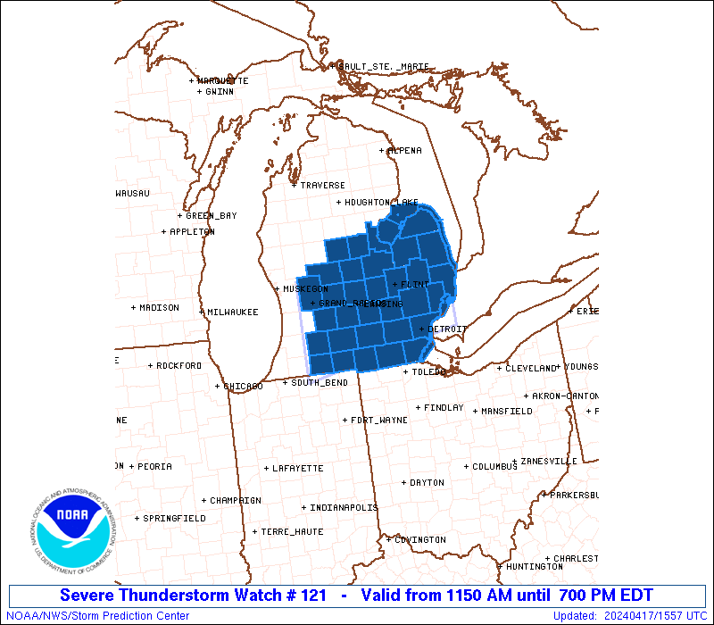
The NWS Storm Prediction Center has issued a
* Severe Thunderstorm Watch for portions of
Central and Southern Lower Michigan
Lake Erie
Lake Huron
* Effective this Wednesday morning and evening from 1150 AM until
700 PM EDT.
* Primary threats include...
Scattered damaging wind gusts to 70 mph possible
Scattered large hail events to 1.5 inches in diameter possible
A tornado or two possible
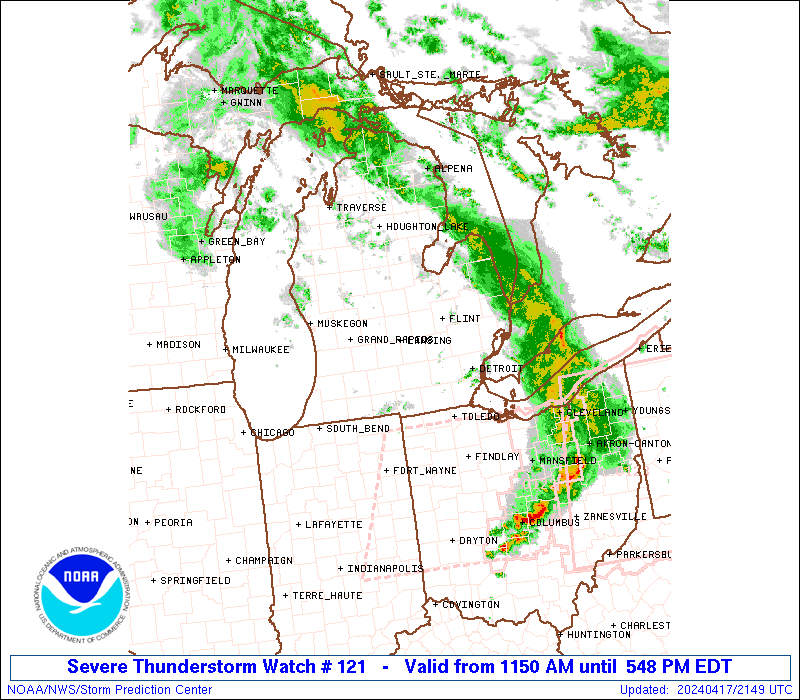
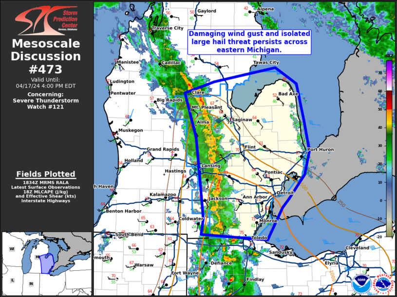
SUMMARY...A line of thunderstorms currently developing across
southwestern Lower Michigan is expected to continue northeastward
throughout the day while intensifying. Primary severe hazards within
this developing line will be damaging gusts, with some isolated hail
possible as well.
The severe thunderstorm watch area is approximately along and 55
statute miles north and south of a line from 20 miles northwest of
Kalamazoo MI to 30 miles north northeast of Mount Clemens MI. For a
complete depiction of the watch see the associated watch outline
update (WOUS64 KWNS WOU1).
PRECAUTIONARY/PREPAREDNESS ACTIONS...
REMEMBER...A Severe Thunderstorm Watch means conditions are
favorable for severe thunderstorms in and close to the watch area.
Persons in these areas should be on the lookout for threatening
weather conditions and listen for later statements and possible
warnings. Severe thunderstorms can and occasionally do produce
tornadoes.
&&
AVIATION...A few severe thunderstorms with hail surface and aloft to
1.5 inches. Extreme turbulence and surface wind gusts to 60 knots. A
few cumulonimbi with maximum tops to 500. Mean storm motion vector
24030.
...Mosier

   SEL1

   URGENT - IMMEDIATE BROADCAST REQUESTED
   Severe Thunderstorm Watch Number 121
   NWS Storm Prediction Center Norman OK
   1150 AM EDT Wed Apr 17 2024

   The NWS Storm Prediction Center has issued a

   * Severe Thunderstorm Watch for portions of
     Central and Southern Lower Michigan
     Lake Erie
     Lake Huron

   * Effective this Wednesday morning and evening from 1150 AM until
     700 PM EDT.

   * Primary threats include...
     Scattered damaging wind gusts to 70 mph possible
     Scattered large hail events to 1.5 inches in diameter possible
     A tornado or two possible

   SUMMARY...A line of thunderstorms currently developing across
   southwestern Lower Michigan is expected to continue northeastward
   throughout the day while intensifying. Primary severe hazards within
   this developing line will be damaging gusts, with some isolated hail
   possible as well.

   The severe thunderstorm watch area is approximately along and 55
   statute miles north and south of a line from 20 miles northwest of
   Kalamazoo MI to 30 miles north northeast of Mount Clemens MI. For a
   complete depiction of the watch see the associated watch outline
   update (WOUS64 KWNS WOU1).

   PRECAUTIONARY/PREPAREDNESS ACTIONS...

   REMEMBER...A Severe Thunderstorm Watch means conditions are
   favorable for severe thunderstorms in and close to the watch area.
   Persons in these areas should be on the lookout for threatening
   weather conditions and listen for later statements and possible
   warnings. Severe thunderstorms can and occasionally do produce
   tornadoes.

   &&

   AVIATION...A few severe thunderstorms with hail surface and aloft to
   1.5 inches. Extreme turbulence and surface wind gusts to 60 knots. A
   few cumulonimbi with maximum tops to 500. Mean storm motion vector
   24030.

   ...Mosier
 Note:
The Aviation Watch (SAW) product is an approximation to the watch area.
The actual watch is depicted by the shaded areas.
Note:
The Aviation Watch (SAW) product is an approximation to the watch area.
The actual watch is depicted by the shaded areas.
   SAW1
   WW 121 SEVERE TSTM MI LE LH 171550Z - 172300Z
   AXIS..55 STATUTE MILES NORTH AND SOUTH OF LINE..
   20NW AZO/KALAMAZOO MI/ - 30NNE MTC/MOUNT CLEMENS MI/
   ..AVIATION COORDS.. 50NM N/S /13E PMM - 16SSE ECK/
   HAIL SURFACE AND ALOFT..1.5 INCHES. WIND GUSTS..60 KNOTS.
   MAX TOPS TO 500. MEAN STORM MOTION VECTOR 24030.

   LAT...LON 43238583 43808260 42208260 41648583

   THIS IS AN APPROXIMATION TO THE WATCH AREA.  FOR A
   COMPLETE DEPICTION OF THE WATCH SEE WOUS64 KWNS
   FOR WOU1.
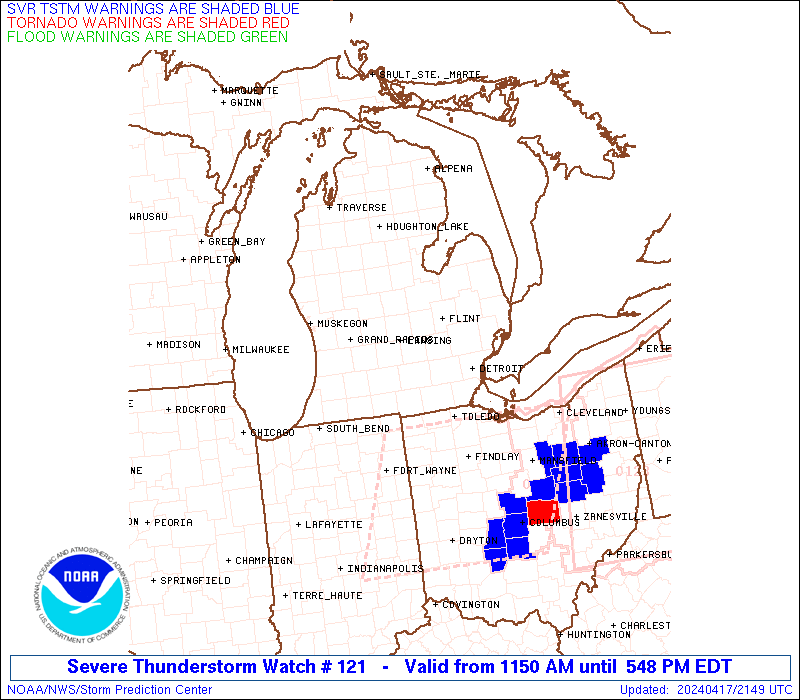
Watch 121 Status Report Messages:
STATUS REPORT #4 ON WW 121

VALID 172040Z - 172140Z

SEVERE WEATHER THREAT CONTINUES RIGHT OF A LINE FROM 20 ESE MTC
TO 35 ENE FNT TO 20 SE OSC.

..LEITMAN..04/17/24

ATTN...WFO...GRR...DTX...IWX...

&&

STATUS REPORT FOR WS 121

SEVERE WEATHER THREAT CONTINUES FOR THE FOLLOWING AREAS

MIC063-147-151-172140-

MI
.    MICHIGAN COUNTIES INCLUDED ARE

HURON		     ST. CLAIR		 SANILAC
$$


LCZ422-LHZ421-441-442-443-172140-

CW

.    ADJACENT COASTAL WATERS INCLUDED ARE

ST. CLAIR RIVER

OUTER SAGINAW BAY SW OF ALABASTER TO PORT AUSTIN MI TO INNER
SAGINAW BAY

PORT AUSTIN TO HARBOR BEACH MI

HARBOR BEACH TO PORT SANILAC MI

PORT SANILAC TO PORT HURON MI

$$
THE WATCH STATUS MESSAGE IS FOR GUIDANCE PURPOSES ONLY.  PLEASE
REFER TO WATCH COUNTY NOTIFICATION STATEMENTS FOR OFFICIAL
INFORMATION ON COUNTIES...INDEPENDENT CITIES AND MARINE ZONES
CLEARED FROM SEVERE THUNDERSTORM AND TORNADO WATCHES.
$$

STATUS REPORT #3 ON WW 121

VALID 171920Z - 172040Z

SEVERE WEATHER THREAT CONTINUES RIGHT OF A LINE FROM 15 NE TOL TO
25 S FNT TO 20 SE MBS TO 15 NNE MBS.

..LEITMAN..04/17/24

ATTN...WFO...GRR...DTX...IWX...

&&

STATUS REPORT FOR WS 121

SEVERE WEATHER THREAT CONTINUES FOR THE FOLLOWING AREAS

MIC049-063-087-099-115-125-147-151-157-163-172040-

MI
.    MICHIGAN COUNTIES INCLUDED ARE

GENESEE 	     HURON		 LAPEER
MACOMB		     MONROE		 OAKLAND
ST. CLAIR	     SANILAC		 TUSCOLA
WAYNE
$$


LCZ422-423-460-LEZ444-LHZ421-422-441-442-443-172040-

CW

.    ADJACENT COASTAL WATERS INCLUDED ARE

ST. CLAIR RIVER

DETROIT RIVER

LAKE ST. CLAIR OPEN LAKE (U.S. PORTION)

MICHIGAN WATERS OF LAKE ERIE FROM DETROIT RIVER TO NORTH CAPE MI

OUTER SAGINAW BAY SW OF ALABASTER TO PORT AUSTIN MI TO INNER
SAGINAW BAY

INNER SAGINAW BAY SW OF POINT AU GRES TO BAY PORT MI

PORT AUSTIN TO HARBOR BEACH MI

HARBOR BEACH TO PORT SANILAC MI

PORT SANILAC TO PORT HURON MI

$$
THE WATCH STATUS MESSAGE IS FOR GUIDANCE PURPOSES ONLY.  PLEASE
REFER TO WATCH COUNTY NOTIFICATION STATEMENTS FOR OFFICIAL
INFORMATION ON COUNTIES...INDEPENDENT CITIES AND MARINE ZONES
CLEARED FROM SEVERE THUNDERSTORM AND TORNADO WATCHES.
$$

STATUS REPORT #2 ON WW 121

VALID 171825Z - 171940Z

SEVERE WEATHER THREAT CONTINUES RIGHT OF A LINE FROM 40 W TOL TO
5 ESE LAN TO 40 WNW MBS.

..LEITMAN..04/17/24

ATTN...WFO...GRR...DTX...IWX...

&&

STATUS REPORT FOR WS 121

SEVERE WEATHER THREAT CONTINUES FOR THE FOLLOWING AREAS

MIC017-049-063-087-091-093-099-111-115-125-145-147-151-155-157-
161-163-171940-

MI
.    MICHIGAN COUNTIES INCLUDED ARE

BAY		     GENESEE		 HURON
LAPEER		     LENAWEE		 LIVINGSTON
MACOMB		     MIDLAND		 MONROE
OAKLAND 	     SAGINAW		 ST. CLAIR
SANILAC 	     SHIAWASSEE 	 TUSCOLA
WASHTENAW	     WAYNE
$$


LCZ422-423-460-LEZ444-LHZ421-422-441-442-443-171940-

CW

.    ADJACENT COASTAL WATERS INCLUDED ARE

ST. CLAIR RIVER

DETROIT RIVER

LAKE ST. CLAIR OPEN LAKE (U.S. PORTION)

MICHIGAN WATERS OF LAKE ERIE FROM DETROIT RIVER TO NORTH CAPE MI

OUTER SAGINAW BAY SW OF ALABASTER TO PORT AUSTIN MI TO INNER
SAGINAW BAY

INNER SAGINAW BAY SW OF POINT AU GRES TO BAY PORT MI

PORT AUSTIN TO HARBOR BEACH MI

HARBOR BEACH TO PORT SANILAC MI

PORT SANILAC TO PORT HURON MI

$$
THE WATCH STATUS MESSAGE IS FOR GUIDANCE PURPOSES ONLY.  PLEASE
REFER TO WATCH COUNTY NOTIFICATION STATEMENTS FOR OFFICIAL
INFORMATION ON COUNTIES...INDEPENDENT CITIES AND MARINE ZONES
CLEARED FROM SEVERE THUNDERSTORM AND TORNADO WATCHES.
$$

STATUS REPORT #1 ON WW 121

VALID 171725Z - 171840Z

SEVERE WEATHER THREAT CONTINUES RIGHT OF A LINE FROM 40 SSE AZO
TO 20 ESE GRR TO 35 N GRR.

..LEITMAN..04/17/24

ATTN...WFO...GRR...DTX...IWX...

&&

STATUS REPORT FOR WS 121

SEVERE WEATHER THREAT CONTINUES FOR THE FOLLOWING AREAS

MIC017-023-025-037-045-049-057-059-063-065-067-073-075-087-091-
093-099-111-115-117-125-145-147-151-155-157-161-163-171840-

MI
.    MICHIGAN COUNTIES INCLUDED ARE

BAY		     BRANCH		 CALHOUN
CLINTON 	     EATON		 GENESEE
GRATIOT 	     HILLSDALE		 HURON
INGHAM		     IONIA		 ISABELLA
JACKSON 	     LAPEER		 LENAWEE
LIVINGSTON	     MACOMB		 MIDLAND
MONROE		     MONTCALM		 OAKLAND
SAGINAW 	     ST. CLAIR		 SANILAC
SHIAWASSEE	     TUSCOLA		 WASHTENAW
WAYNE
$$


LCZ422-423-460-LEZ444-LHZ421-422-441-442-443-171840-

CW

.    ADJACENT COASTAL WATERS INCLUDED ARE

ST. CLAIR RIVER

DETROIT RIVER

LAKE ST. CLAIR OPEN LAKE (U.S. PORTION)

MICHIGAN WATERS OF LAKE ERIE FROM DETROIT RIVER TO NORTH CAPE MI

OUTER SAGINAW BAY SW OF ALABASTER TO PORT AUSTIN MI TO INNER
SAGINAW BAY

INNER SAGINAW BAY SW OF POINT AU GRES TO BAY PORT MI

PORT AUSTIN TO HARBOR BEACH MI

HARBOR BEACH TO PORT SANILAC MI

PORT SANILAC TO PORT HURON MI

$$
THE WATCH STATUS MESSAGE IS FOR GUIDANCE PURPOSES ONLY.  PLEASE
REFER TO WATCH COUNTY NOTIFICATION STATEMENTS FOR OFFICIAL
INFORMATION ON COUNTIES...INDEPENDENT CITIES AND MARINE ZONES
CLEARED FROM SEVERE THUNDERSTORM AND TORNADO WATCHES.
$$
Note:
Click for Complete Product Text.
Tornadoes
Probability of 2 or more tornadoes
|
Low (20%)
|
Probability of 1 or more strong (EF2-EF5) tornadoes
|
Low (<2%)
|
Wind
Probability of 10 or more severe wind events
|
Mod (40%)
|
Probability of 1 or more wind events > 65 knots
|
Low (20%)
|
Hail
Probability of 10 or more severe hail events
|
Mod (40%)
|
Probability of 1 or more hailstones > 2 inches
|
Low (20%)
|
Combined Severe Hail/Wind
Probability of 6 or more combined severe hail/wind events
|
High (70%)
|
For each watch, probabilities for particular events inside the watch
(listed above in each table) are determined by the issuing forecaster.
The "Low" category contains probability values ranging from less than 2%
to 20% (EF2-EF5 tornadoes), less than 5% to 20% (all other probabilities),
"Moderate" from 30% to 60%, and "High" from 70% to greater than 95%.
High values are bolded and lighter in color to provide awareness of
an increased threat for a particular event.


 @NWSSPC