 Note:
The expiration time in the watch graphic is amended if the watch is
replaced, cancelled or extended.
Note:
Note:
The expiration time in the watch graphic is amended if the watch is
replaced, cancelled or extended.
Note: Click for
Watch Status Reports.
SEL8
URGENT - IMMEDIATE BROADCAST REQUESTED
Tornado Watch Number 118
NWS Storm Prediction Center Norman OK
1225 PM CDT Tue Apr 16 2024
The NWS Storm Prediction Center has issued a
* Tornado Watch for portions of
Western and Northern Iowa
Northeast Nebraska
Southeast South Dakota
* Effective this Tuesday afternoon and evening from 1225 PM until
700 PM CDT.
* Primary threats include...
A couple tornadoes possible
Scattered large hail events to 1.5 inches in diameter possible
Isolated damaging wind gusts to 60 mph possible
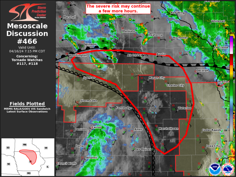
SUMMARY...A tornado/hail risk will exist through the afternoon as
far west as northeast Nebraska and southeast South Dakota near a
surface low, with other severe storms expected to develop into
additional parts of Iowa.
The tornado watch area is approximately along and 65 statute miles
north and south of a line from 30 miles north of Norfolk NE to 35
miles east of Fort Dodge IA. For a complete depiction of the watch
see the associated watch outline update (WOUS64 KWNS WOU8).
PRECAUTIONARY/PREPAREDNESS ACTIONS...
REMEMBER...A Tornado Watch means conditions are favorable for
tornadoes and severe thunderstorms in and close to the watch
area. Persons in these areas should be on the lookout for
threatening weather conditions and listen for later statements
and possible warnings.
&&
OTHER WATCH INFORMATION...CONTINUE...WW 116...WW 117...
AVIATION...Tornadoes and a few severe thunderstorms with hail
surface and aloft to 1.5 inches. Extreme turbulence and surface wind
gusts to 50 knots. A few cumulonimbi with maximum tops to 450. Mean
storm motion vector 22035.
...Guyer

   SEL8

   URGENT - IMMEDIATE BROADCAST REQUESTED
   Tornado Watch Number 118
   NWS Storm Prediction Center Norman OK
   1225 PM CDT Tue Apr 16 2024

   The NWS Storm Prediction Center has issued a

   * Tornado Watch for portions of
     Western and Northern Iowa
     Northeast Nebraska
     Southeast South Dakota

   * Effective this Tuesday afternoon and evening from 1225 PM until
     700 PM CDT.

   * Primary threats include...
     A couple tornadoes possible
     Scattered large hail events to 1.5 inches in diameter possible
     Isolated damaging wind gusts to 60 mph possible

   SUMMARY...A tornado/hail risk will exist through the afternoon as
   far west as northeast Nebraska and southeast South Dakota near a
   surface low, with other severe storms expected to develop into
   additional parts of Iowa.

   The tornado watch area is approximately along and 65 statute miles
   north and south of a line from 30 miles north of Norfolk NE to 35
   miles east of Fort Dodge IA. For a complete depiction of the watch
   see the associated watch outline update (WOUS64 KWNS WOU8).

   PRECAUTIONARY/PREPAREDNESS ACTIONS...

   REMEMBER...A Tornado Watch means conditions are favorable for
   tornadoes and severe thunderstorms in and close to the watch
   area. Persons in these areas should be on the lookout for
   threatening weather conditions and listen for later statements
   and possible warnings.

   &&

   OTHER WATCH INFORMATION...CONTINUE...WW 116...WW 117...

   AVIATION...Tornadoes and a few severe thunderstorms with hail
   surface and aloft to 1.5 inches. Extreme turbulence and surface wind
   gusts to 50 knots. A few cumulonimbi with maximum tops to 450. Mean
   storm motion vector 22035.

   ...Guyer
 Note:
The Aviation Watch (SAW) product is an approximation to the watch area.
The actual watch is depicted by the shaded areas.
Note:
The Aviation Watch (SAW) product is an approximation to the watch area.
The actual watch is depicted by the shaded areas.
   SAW8
   WW 118 TORNADO IA NE SD 161725Z - 170000Z
   AXIS..65 STATUTE MILES NORTH AND SOUTH OF LINE..
   30N OFK/NORFOLK NE/ - 35E FOD/FORT DODGE IA/
   ..AVIATION COORDS.. 55NM N/S /56E ONL - 34SSW MCW/
   HAIL SURFACE AND ALOFT..1.5 INCHES. WIND GUSTS..50 KNOTS.
   MAX TOPS TO 450. MEAN STORM MOTION VECTOR 22035.

   LAT...LON 43359743 43499351 41619351 41479743

   THIS IS AN APPROXIMATION TO THE WATCH AREA.  FOR A
   COMPLETE DEPICTION OF THE WATCH SEE WOUS64 KWNS
   FOR WOU8.
Watch 118 Status Report Messages:
STATUS REPORT #5 ON WW 118

VALID 162245Z - 162340Z

SEVERE WEATHER THREAT CONTINUES RIGHT OF A LINE FROM 10 ENE DSM
TO 30 SE FOD TO 10 NE FOD TO 20 ESE SPW TO 15 WNW SPW TO 20 E FSD.

..LYONS..04/16/24

ATTN...WFO...DMX...FSD...OAX...

&&

STATUS REPORT FOR WT 118

SEVERE WEATHER THREAT CONTINUES FOR THE FOLLOWING AREAS

IAC059-063-081-091-109-147-189-195-162340-

IA
.    IOWA COUNTIES INCLUDED ARE

DICKINSON	     EMMET		 HANCOCK
HUMBOLDT	     KOSSUTH		 PALO ALTO
WINNEBAGO	     WORTH
$$


THE WATCH STATUS MESSAGE IS FOR GUIDANCE PURPOSES ONLY.  PLEASE
REFER TO WATCH COUNTY NOTIFICATION STATEMENTS FOR OFFICIAL
INFORMATION ON COUNTIES...INDEPENDENT CITIES AND MARINE ZONES
CLEARED FROM SEVERE THUNDERSTORM AND TORNADO WATCHES.
$$

STATUS REPORT #4 ON WW 118

VALID 162050Z - 162140Z

SEVERE WEATHER THREAT CONTINUES RIGHT OF A LINE FROM 25 W DSM TO
40 NW DSM TO 20 WSW FOD TO 35 WSW SPW TO 10 WNW FSD.

..BENTLEY..04/16/24

ATTN...WFO...DMX...FSD...OAX...

&&

STATUS REPORT FOR WT 118

SEVERE WEATHER THREAT CONTINUES FOR THE FOLLOWING AREAS

IAC021-041-059-063-081-091-109-119-141-143-147-151-167-187-189-
195-162140-

IA
.    IOWA COUNTIES INCLUDED ARE

BUENA VISTA	     CLAY		 DICKINSON
EMMET		     HANCOCK		 HUMBOLDT
KOSSUTH 	     LYON		 O'BRIEN
OSCEOLA 	     PALO ALTO		 POCAHONTAS
SIOUX		     WEBSTER		 WINNEBAGO
WORTH
$$


THE WATCH STATUS MESSAGE IS FOR GUIDANCE PURPOSES ONLY.  PLEASE
REFER TO WATCH COUNTY NOTIFICATION STATEMENTS FOR OFFICIAL
INFORMATION ON COUNTIES...INDEPENDENT CITIES AND MARINE ZONES
CLEARED FROM SEVERE THUNDERSTORM AND TORNADO WATCHES.
$$

STATUS REPORT #3 ON WW 118

VALID 162020Z - 162140Z

SEVERE WEATHER THREAT CONTINUES RIGHT OF A LINE FROM 25 WNW OMA
TO 20 NNW TQE TO 10 ENE SUX TO 35 N SUX TO 5 ENE FSD.

..BENTLEY..04/16/24

ATTN...WFO...DMX...FSD...OAX...

&&

STATUS REPORT FOR WT 118

SEVERE WEATHER THREAT CONTINUES FOR THE FOLLOWING AREAS

IAC009-021-025-027-035-041-047-059-063-073-077-081-085-091-093-
109-119-133-141-143-147-149-151-161-165-167-187-189-193-195-
162140-

IA
.    IOWA COUNTIES INCLUDED ARE

AUDUBON 	     BUENA VISTA	 CALHOUN
CARROLL 	     CHEROKEE		 CLAY
CRAWFORD	     DICKINSON		 EMMET
GREENE		     GUTHRIE		 HANCOCK
HARRISON	     HUMBOLDT		 IDA
KOSSUTH 	     LYON		 MONONA
O'BRIEN 	     OSCEOLA		 PALO ALTO
PLYMOUTH	     POCAHONTAS 	 SAC
SHELBY		     SIOUX		 WEBSTER
WINNEBAGO	     WOODBURY		 WORTH
$$


NEC021-162140-

NE
.    NEBRASKA COUNTIES INCLUDED ARE

BURT
$$


THE WATCH STATUS MESSAGE IS FOR GUIDANCE PURPOSES ONLY.  PLEASE
REFER TO WATCH COUNTY NOTIFICATION STATEMENTS FOR OFFICIAL
INFORMATION ON COUNTIES...INDEPENDENT CITIES AND MARINE ZONES
CLEARED FROM SEVERE THUNDERSTORM AND TORNADO WATCHES.
$$

STATUS REPORT #2 ON WW 118

VALID 161940Z - 162040Z

THE SEVERE WEATHER THREAT CONTINUES ACROSS THE ENTIRE WATCH AREA.

..BENTLEY..04/16/24

ATTN...WFO...DMX...FSD...OAX...

&&

STATUS REPORT FOR WT 118

SEVERE WEATHER THREAT CONTINUES FOR THE FOLLOWING AREAS

IAC009-021-025-027-035-041-047-059-063-073-077-081-085-091-093-
109-119-133-141-143-147-149-151-161-165-167-187-189-193-195-
162040-

IA
.    IOWA COUNTIES INCLUDED ARE

AUDUBON 	     BUENA VISTA	 CALHOUN
CARROLL 	     CHEROKEE		 CLAY
CRAWFORD	     DICKINSON		 EMMET
GREENE		     GUTHRIE		 HANCOCK
HARRISON	     HUMBOLDT		 IDA
KOSSUTH 	     LYON		 MONONA
O'BRIEN 	     OSCEOLA		 PALO ALTO
PLYMOUTH	     POCAHONTAS 	 SAC
SHELBY		     SIOUX		 WEBSTER
WINNEBAGO	     WOODBURY		 WORTH
$$


NEC021-027-039-043-051-119-167-173-179-162040-

NE
.    NEBRASKA COUNTIES INCLUDED ARE

BURT		     CEDAR		 CUMING
DAKOTA		     DIXON		 MADISON
STANTON 	     THURSTON		 WAYNE
$$


SDC027-127-162040-

SD
.    SOUTH DAKOTA COUNTIES INCLUDED ARE

CLAY		     UNION
$$


THE WATCH STATUS MESSAGE IS FOR GUIDANCE PURPOSES ONLY.  PLEASE
REFER TO WATCH COUNTY NOTIFICATION STATEMENTS FOR OFFICIAL
INFORMATION ON COUNTIES...INDEPENDENT CITIES AND MARINE ZONES
CLEARED FROM SEVERE THUNDERSTORM AND TORNADO WATCHES.
$$

STATUS REPORT #1 ON WW 118

VALID 161835Z - 161940Z

THE SEVERE WEATHER THREAT CONTINUES ACROSS THE ENTIRE WATCH AREA.

..LEITMAN..04/16/24

ATTN...WFO...DMX...FSD...OAX...

&&

STATUS REPORT FOR WT 118

SEVERE WEATHER THREAT CONTINUES FOR THE FOLLOWING AREAS

IAC009-021-025-027-029-035-041-047-059-063-073-077-081-085-091-
093-109-119-133-141-143-147-149-151-161-165-167-187-189-193-195-
161940-

IA
.    IOWA COUNTIES INCLUDED ARE

AUDUBON 	     BUENA VISTA	 CALHOUN
CARROLL 	     CASS		 CHEROKEE
CLAY		     CRAWFORD		 DICKINSON
EMMET		     GREENE		 GUTHRIE
HANCOCK 	     HARRISON		 HUMBOLDT
IDA		     KOSSUTH		 LYON
MONONA		     O'BRIEN		 OSCEOLA
PALO ALTO	     PLYMOUTH		 POCAHONTAS
SAC		     SHELBY		 SIOUX
WEBSTER 	     WINNEBAGO		 WOODBURY
WORTH
$$


NEC021-027-039-043-051-119-167-173-179-161940-

NE
.    NEBRASKA COUNTIES INCLUDED ARE

BURT		     CEDAR		 CUMING
DAKOTA		     DIXON		 MADISON
STANTON 	     THURSTON		 WAYNE
$$


SDC027-127-161940-

SD
.    SOUTH DAKOTA COUNTIES INCLUDED ARE

CLAY		     UNION
$$


THE WATCH STATUS MESSAGE IS FOR GUIDANCE PURPOSES ONLY.  PLEASE
REFER TO WATCH COUNTY NOTIFICATION STATEMENTS FOR OFFICIAL
INFORMATION ON COUNTIES...INDEPENDENT CITIES AND MARINE ZONES
CLEARED FROM SEVERE THUNDERSTORM AND TORNADO WATCHES.
$$
Note:
Click for Complete Product Text.
Tornadoes
Probability of 2 or more tornadoes
|
Mod (40%)
|
Probability of 1 or more strong (EF2-EF5) tornadoes
|
Low (20%)
|
Wind
Probability of 10 or more severe wind events
|
Mod (30%)
|
Probability of 1 or more wind events > 65 knots
|
Low (10%)
|
Hail
Probability of 10 or more severe hail events
|
Mod (40%)
|
Probability of 1 or more hailstones > 2 inches
|
Low (10%)
|
Combined Severe Hail/Wind
Probability of 6 or more combined severe hail/wind events
|
High (80%)
|
For each watch, probabilities for particular events inside the watch
(listed above in each table) are determined by the issuing forecaster.
The "Low" category contains probability values ranging from less than 2%
to 20% (EF2-EF5 tornadoes), less than 5% to 20% (all other probabilities),
"Moderate" from 30% to 60%, and "High" from 70% to greater than 95%.
High values are bolded and lighter in color to provide awareness of
an increased threat for a particular event.


 @NWSSPC