 Note:
The expiration time in the watch graphic is amended if the watch is
replaced, cancelled or extended.
Note:
Note:
The expiration time in the watch graphic is amended if the watch is
replaced, cancelled or extended.
Note: Click for
Watch Status Reports.
SEL5
URGENT - IMMEDIATE BROADCAST REQUESTED
Severe Thunderstorm Watch Number 55
NWS Storm Prediction Center Norman OK
745 PM CDT Fri Mar 15 2024
The NWS Storm Prediction Center has issued a
* Severe Thunderstorm Watch for portions of
South Texas
* Effective this Friday night and Saturday morning from 745 PM
until 300 AM CDT.
* Primary threats include...
Scattered large hail and isolated very large hail events to 2.5
inches in diameter likely
Scattered damaging wind gusts to 70 mph possible
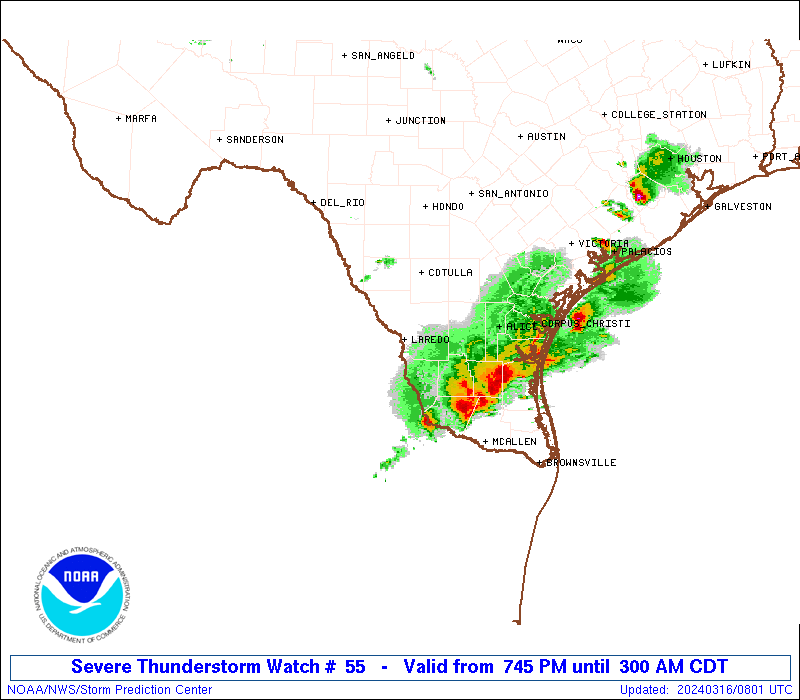
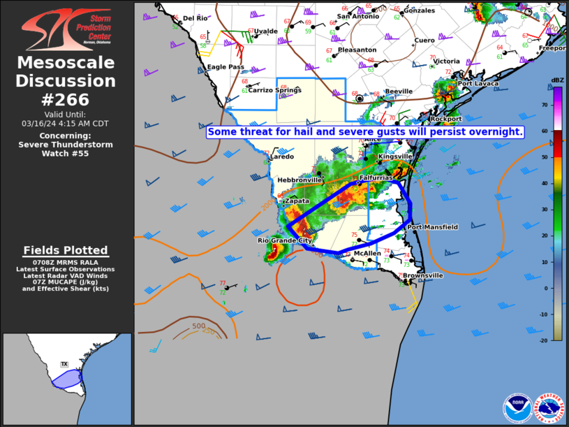
SUMMARY...Severe thunderstorms currently just west of the Rio Grande
will build eastward into South Texas tonight, posing a risk of very
large hail and damaging winds.
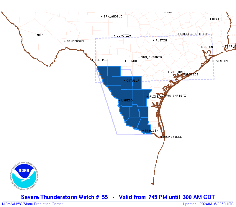
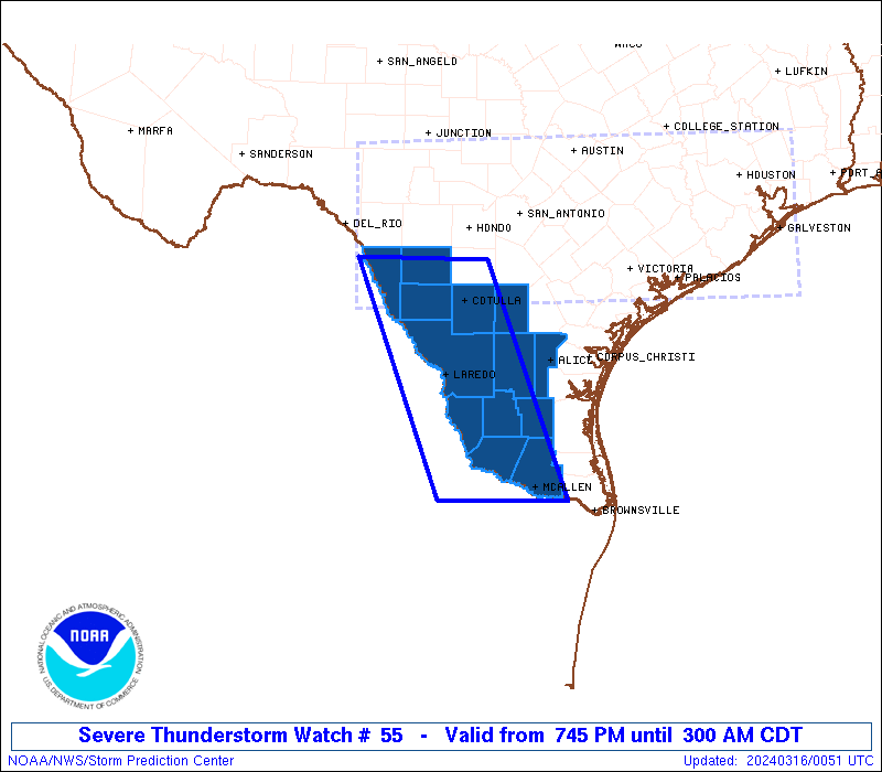
The severe thunderstorm watch area is approximately along and 55
statute miles east and west of a line from 50 miles northwest of
Cotulla TX to 30 miles west southwest of Mcallen TX. For a complete
depiction of the watch see the associated watch outline update
(WOUS64 KWNS WOU5).
PRECAUTIONARY/PREPAREDNESS ACTIONS...
REMEMBER...A Severe Thunderstorm Watch means conditions are
favorable for severe thunderstorms in and close to the watch area.
Persons in these areas should be on the lookout for threatening
weather conditions and listen for later statements and possible
warnings. Severe thunderstorms can and occasionally do produce
tornadoes.
&&
OTHER WATCH INFORMATION...CONTINUE...WW 54...
AVIATION...A few severe thunderstorms with hail surface and aloft to
2.5 inches. Extreme turbulence and surface wind gusts to 60 knots. A
few cumulonimbi with maximum tops to 500. Mean storm motion vector
29035.
...Hart

   SEL5

   URGENT - IMMEDIATE BROADCAST REQUESTED
   Severe Thunderstorm Watch Number 55
   NWS Storm Prediction Center Norman OK
   745 PM CDT Fri Mar 15 2024

   The NWS Storm Prediction Center has issued a

   * Severe Thunderstorm Watch for portions of
     South Texas

   * Effective this Friday night and Saturday morning from 745 PM
     until 300 AM CDT.

   * Primary threats include...
     Scattered large hail and isolated very large hail events to 2.5
       inches in diameter likely
     Scattered damaging wind gusts to 70 mph possible

   SUMMARY...Severe thunderstorms currently just west of the Rio Grande
   will build eastward into South Texas tonight, posing a risk of very
   large hail and damaging winds.

   The severe thunderstorm watch area is approximately along and 55
   statute miles east and west of a line from 50 miles northwest of
   Cotulla TX to 30 miles west southwest of Mcallen TX. For a complete
   depiction of the watch see the associated watch outline update
   (WOUS64 KWNS WOU5).

   PRECAUTIONARY/PREPAREDNESS ACTIONS...

   REMEMBER...A Severe Thunderstorm Watch means conditions are
   favorable for severe thunderstorms in and close to the watch area.
   Persons in these areas should be on the lookout for threatening
   weather conditions and listen for later statements and possible
   warnings. Severe thunderstorms can and occasionally do produce
   tornadoes.

   &&

   OTHER WATCH INFORMATION...CONTINUE...WW 54...

   AVIATION...A few severe thunderstorms with hail surface and aloft to
   2.5 inches. Extreme turbulence and surface wind gusts to 60 knots. A
   few cumulonimbi with maximum tops to 500. Mean storm motion vector
   29035.

   ...Hart
 Note:
The Aviation Watch (SAW) product is an approximation to the watch area.
The actual watch is depicted by the shaded areas.
Note:
The Aviation Watch (SAW) product is an approximation to the watch area.
The actual watch is depicted by the shaded areas.
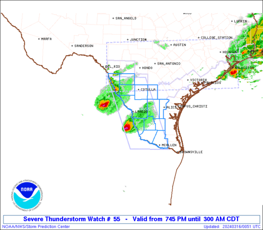
   SAW5
   WW 55 SEVERE TSTM TX 160045Z - 160800Z
   AXIS..55 STATUTE MILES EAST AND WEST OF LINE..
   50NW COT/COTULLA TX/ - 30WSW MFE/MCALLEN TX/
   ..AVIATION COORDS.. 50NM E/W /56ESE DLF - 70W BRO/
   HAIL SURFACE AND ALOFT..2.5 INCHES. WIND GUSTS..60 KNOTS.
   MAX TOPS TO 500. MEAN STORM MOTION VECTOR 29035.

   LAT...LON 28969890 26019779 26019956 28960071

   THIS IS AN APPROXIMATION TO THE WATCH AREA.  FOR A
   COMPLETE DEPICTION OF THE WATCH SEE WOUS64 KWNS
   FOR WOU5.
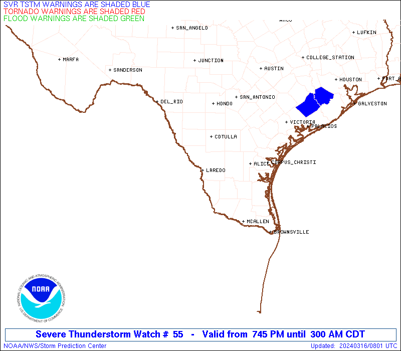
Watch 55 Status Report Messages:
STATUS REPORT #3 ON WW 55

VALID 160610Z - 160740Z

SEVERE WEATHER THREAT CONTINUES RIGHT OF A LINE FROM 75 SSW LRD
TO 45 WSW ALI TO 10 ESE NIR.

FOR ADDITIONAL INFORMATION SEE MESOSCALE DISCUSSION 265

..DEAN..03/16/24

ATTN...WFO...BRO...EWX...CRP...

&&

STATUS REPORT FOR WS 55

SEVERE WEATHER THREAT CONTINUES FOR THE FOLLOWING AREAS

TXC047-131-215-247-249-427-505-160740-

TX
.    TEXAS COUNTIES INCLUDED ARE

BROOKS		     DUVAL		 HIDALGO
JIM HOGG	     JIM WELLS		 STARR
ZAPATA
$$


THE WATCH STATUS MESSAGE IS FOR GUIDANCE PURPOSES ONLY.  PLEASE
REFER TO WATCH COUNTY NOTIFICATION STATEMENTS FOR OFFICIAL
INFORMATION ON COUNTIES...INDEPENDENT CITIES AND MARINE ZONES
CLEARED FROM SEVERE THUNDERSTORM AND TORNADO WATCHES.
$$

STATUS REPORT #2 ON WW 55

VALID 160430Z - 160540Z

SEVERE WEATHER THREAT CONTINUES RIGHT OF A LINE FROM 50 SW LRD TO
10 WNW LRD TO 45 NW NIR.

..BROYLES..03/16/24

ATTN...WFO...BRO...EWX...CRP...

&&

STATUS REPORT FOR WS 55

SEVERE WEATHER THREAT CONTINUES FOR THE FOLLOWING AREAS

TXC047-131-215-247-249-311-427-479-505-160540-

TX
.    TEXAS COUNTIES INCLUDED ARE

BROOKS		     DUVAL		 HIDALGO
JIM HOGG	     JIM WELLS		 MCMULLEN
STARR		     WEBB		 ZAPATA
$$


THE WATCH STATUS MESSAGE IS FOR GUIDANCE PURPOSES ONLY.  PLEASE
REFER TO WATCH COUNTY NOTIFICATION STATEMENTS FOR OFFICIAL
INFORMATION ON COUNTIES...INDEPENDENT CITIES AND MARINE ZONES
CLEARED FROM SEVERE THUNDERSTORM AND TORNADO WATCHES.
$$

STATUS REPORT #1 ON WW 55

VALID 160240Z - 160340Z

SEVERE WEATHER THREAT CONTINUES RIGHT OF A LINE FROM 55 W LRD TO
25 SW COT TO 25 SE HDO.

..BROYLES..03/16/24

ATTN...WFO...BRO...EWX...CRP...

&&

STATUS REPORT FOR WS 55

SEVERE WEATHER THREAT CONTINUES FOR THE FOLLOWING AREAS

TXC047-131-215-247-249-283-311-427-479-505-160340-

TX
.    TEXAS COUNTIES INCLUDED ARE

BROOKS		     DUVAL		 HIDALGO
JIM HOGG	     JIM WELLS		 LA SALLE
MCMULLEN	     STARR		 WEBB
ZAPATA
$$


THE WATCH STATUS MESSAGE IS FOR GUIDANCE PURPOSES ONLY.  PLEASE
REFER TO WATCH COUNTY NOTIFICATION STATEMENTS FOR OFFICIAL
INFORMATION ON COUNTIES...INDEPENDENT CITIES AND MARINE ZONES
CLEARED FROM SEVERE THUNDERSTORM AND TORNADO WATCHES.
$$
Note:
Click for Complete Product Text.
Tornadoes
Probability of 2 or more tornadoes
|
Low (10%)
|
Probability of 1 or more strong (EF2-EF5) tornadoes
|
Low (<2%)
|
Wind
Probability of 10 or more severe wind events
|
Mod (40%)
|
Probability of 1 or more wind events > 65 knots
|
Low (20%)
|
Hail
Probability of 10 or more severe hail events
|
Mod (60%)
|
Probability of 1 or more hailstones > 2 inches
|
Mod (60%)
|
Combined Severe Hail/Wind
Probability of 6 or more combined severe hail/wind events
|
High (90%)
|
For each watch, probabilities for particular events inside the watch
(listed above in each table) are determined by the issuing forecaster.
The "Low" category contains probability values ranging from less than 2%
to 20% (EF2-EF5 tornadoes), less than 5% to 20% (all other probabilities),
"Moderate" from 30% to 60%, and "High" from 70% to greater than 95%.
High values are bolded and lighter in color to provide awareness of
an increased threat for a particular event.


 @NWSSPC