Note:
The expiration time in the watch graphic is amended if the watch is
replaced, cancelled or extended.
Note:
Note:
The expiration time in the watch graphic is amended if the watch is
replaced, cancelled or extended.
Note: Click for
Watch Status Reports.
SEL6
URGENT - IMMEDIATE BROADCAST REQUESTED
Severe Thunderstorm Watch Number 56
NWS Storm Prediction Center Norman OK
1035 PM CDT Sat Mar 16 2024
The NWS Storm Prediction Center has issued a
* Severe Thunderstorm Watch for portions of
southern Texas
Coastal Waters
* Effective this Saturday night and Sunday morning from 1035 PM
until 600 AM CDT.
* Primary threats include...
Scattered large hail and isolated very large hail events to 2
inches in diameter possible
Isolated damaging wind gusts to 70 mph possible
SUMMARY...Thunderstorms west of the Rio Grande will spread eastward
into southern portions of Texas over the next couple of hours.
Large hail will be the primary threat with these storms, though a
few locally severe/damaging wind gusts will also be possible --
particularly across the more southern portions of the WW.
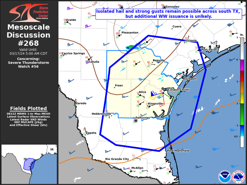
The severe thunderstorm watch area is approximately along and 65
statute miles east and west of a line from 50 miles north northwest
of Cotulla TX to 70 miles south southwest of Alice TX. For a
complete depiction of the watch see the associated watch outline
update (WOUS64 KWNS WOU6).
PRECAUTIONARY/PREPAREDNESS ACTIONS...
REMEMBER...A Severe Thunderstorm Watch means conditions are
favorable for severe thunderstorms in and close to the watch area.
Persons in these areas should be on the lookout for threatening
weather conditions and listen for later statements and possible
warnings. Severe thunderstorms can and occasionally do produce
tornadoes.
&&
AVIATION...A few severe thunderstorms with hail surface and aloft to
2 inches. Extreme turbulence and surface wind gusts to 60 knots. A
few cumulonimbi with maximum tops to 500. Mean storm motion vector
26030.
...Goss

   SEL6

   URGENT - IMMEDIATE BROADCAST REQUESTED
   Severe Thunderstorm Watch Number 56
   NWS Storm Prediction Center Norman OK
   1035 PM CDT Sat Mar 16 2024

   The NWS Storm Prediction Center has issued a

   * Severe Thunderstorm Watch for portions of
     southern Texas
     Coastal Waters

   * Effective this Saturday night and Sunday morning from 1035 PM
     until 600 AM CDT.

   * Primary threats include...
     Scattered large hail and isolated very large hail events to 2
       inches in diameter possible
     Isolated damaging wind gusts to 70 mph possible

   SUMMARY...Thunderstorms west of the Rio Grande will spread eastward
   into southern portions of Texas over the next couple of hours.
   Large hail will be the primary threat with these storms, though a
   few locally severe/damaging wind gusts will also be possible --
   particularly across the more southern portions of the WW.

   The severe thunderstorm watch area is approximately along and 65
   statute miles east and west of a line from 50 miles north northwest
   of Cotulla TX to 70 miles south southwest of Alice TX. For a
   complete depiction of the watch see the associated watch outline
   update (WOUS64 KWNS WOU6).

   PRECAUTIONARY/PREPAREDNESS ACTIONS...

   REMEMBER...A Severe Thunderstorm Watch means conditions are
   favorable for severe thunderstorms in and close to the watch area.
   Persons in these areas should be on the lookout for threatening
   weather conditions and listen for later statements and possible
   warnings. Severe thunderstorms can and occasionally do produce
   tornadoes.

   &&

   AVIATION...A few severe thunderstorms with hail surface and aloft to
   2 inches. Extreme turbulence and surface wind gusts to 60 knots. A
   few cumulonimbi with maximum tops to 500. Mean storm motion vector
   26030.

   ...Goss
 Note:
The Aviation Watch (SAW) product is an approximation to the watch area.
The actual watch is depicted by the shaded areas.
Note:
The Aviation Watch (SAW) product is an approximation to the watch area.
The actual watch is depicted by the shaded areas.
   SAW6
   WW 56 SEVERE TSTM TX CW 170335Z - 171100Z
   AXIS..65 STATUTE MILES EAST AND WEST OF LINE..
   50NNW COT/COTULLA TX/ - 70SSW ALI/ALICE TX/
   ..AVIATION COORDS.. 55NM E/W /64WSW SAT - 66SE LRD/
   HAIL SURFACE AND ALOFT..2 INCHES. WIND GUSTS..60 KNOTS.
   MAX TOPS TO 500. MEAN STORM MOTION VECTOR 26030.

   LAT...LON 29119846 26799741 26799952 29110061

   THIS IS AN APPROXIMATION TO THE WATCH AREA.  FOR A
   COMPLETE DEPICTION OF THE WATCH SEE WOUS64 KWNS
   FOR WOU6.
Watch 56 Status Report Messages:
STATUS REPORT #4 ON WW 56

VALID 170835Z - 170940Z

SEVERE WEATHER THREAT CONTINUES RIGHT OF A LINE FROM 40 SSE CRP
TO 55 SW ALI TO 25 E COT TO 45 SE SAT.

FOR ADDITIONAL INFORMATION SEE MESOSCALE DISCUSSION 268

..DEAN..03/17/24

ATTN...WFO...EWX...CRP...BRO...

&&

STATUS REPORT FOR WS 56

SEVERE WEATHER THREAT CONTINUES FOR THE FOLLOWING AREAS

TXC025-131-249-273-297-311-355-409-170940-

TX
.    TEXAS COUNTIES INCLUDED ARE

BEE		     DUVAL		 JIM WELLS
KLEBERG 	     LIVE OAK		 MCMULLEN
NUECES		     SAN PATRICIO
$$


GMZ231-232-170940-

CW

.    ADJACENT COASTAL WATERS INCLUDED ARE

BAFFIN BAY AND UPPER LAGUNA MADRE

CORPUS CHRISTI AND NUECES BAYS

$$
THE WATCH STATUS MESSAGE IS FOR GUIDANCE PURPOSES ONLY.  PLEASE
REFER TO WATCH COUNTY NOTIFICATION STATEMENTS FOR OFFICIAL
INFORMATION ON COUNTIES...INDEPENDENT CITIES AND MARINE ZONES
CLEARED FROM SEVERE THUNDERSTORM AND TORNADO WATCHES.
$$

STATUS REPORT #3 ON WW 56

VALID 170715Z - 170840Z

SEVERE WEATHER THREAT CONTINUES RIGHT OF A LINE FROM 45 SSW LRD
TO 40 ENE LRD TO 20 N COT TO 45 N HDO.

..DEAN..03/17/24

ATTN...WFO...EWX...CRP...BRO...

&&

STATUS REPORT FOR WS 56

SEVERE WEATHER THREAT CONTINUES FOR THE FOLLOWING AREAS

TXC013-025-047-131-163-247-249-273-283-297-311-325-355-409-427-
479-505-170840-

TX
.    TEXAS COUNTIES INCLUDED ARE

ATASCOSA	     BEE		 BROOKS
DUVAL		     FRIO		 JIM HOGG
JIM WELLS	     KLEBERG		 LA SALLE
LIVE OAK	     MCMULLEN		 MEDINA
NUECES		     SAN PATRICIO	 STARR
WEBB		     ZAPATA
$$


GMZ231-232-170840-

CW

.    ADJACENT COASTAL WATERS INCLUDED ARE

BAFFIN BAY AND UPPER LAGUNA MADRE

CORPUS CHRISTI AND NUECES BAYS

$$
THE WATCH STATUS MESSAGE IS FOR GUIDANCE PURPOSES ONLY.  PLEASE
REFER TO WATCH COUNTY NOTIFICATION STATEMENTS FOR OFFICIAL
INFORMATION ON COUNTIES...INDEPENDENT CITIES AND MARINE ZONES
CLEARED FROM SEVERE THUNDERSTORM AND TORNADO WATCHES.
$$

STATUS REPORT #2 ON WW 56

VALID 170650Z - 170740Z

SEVERE WEATHER THREAT CONTINUES RIGHT OF A LINE FROM 30 SW LRD TO
30 SSW COT TO 35 NNW HDO.

..DEAN..03/17/24

ATTN...WFO...EWX...CRP...BRO...

&&

STATUS REPORT FOR WS 56

SEVERE WEATHER THREAT CONTINUES FOR THE FOLLOWING AREAS

TXC013-025-047-131-163-247-249-273-283-297-311-325-355-409-427-
479-505-170740-

TX
.    TEXAS COUNTIES INCLUDED ARE

ATASCOSA	     BEE		 BROOKS
DUVAL		     FRIO		 JIM HOGG
JIM WELLS	     KLEBERG		 LA SALLE
LIVE OAK	     MCMULLEN		 MEDINA
NUECES		     SAN PATRICIO	 STARR
WEBB		     ZAPATA
$$


GMZ231-232-170740-

CW

.    ADJACENT COASTAL WATERS INCLUDED ARE

BAFFIN BAY AND UPPER LAGUNA MADRE

CORPUS CHRISTI AND NUECES BAYS

$$
THE WATCH STATUS MESSAGE IS FOR GUIDANCE PURPOSES ONLY.  PLEASE
REFER TO WATCH COUNTY NOTIFICATION STATEMENTS FOR OFFICIAL
INFORMATION ON COUNTIES...INDEPENDENT CITIES AND MARINE ZONES
CLEARED FROM SEVERE THUNDERSTORM AND TORNADO WATCHES.
$$

STATUS REPORT #1 ON WW 56

VALID 170540Z - 170640Z

SEVERE WEATHER THREAT CONTINUES RIGHT OF A LINE FROM 55 NW LRD TO
45 S JCT.

..DEAN..03/17/24

ATTN...WFO...EWX...CRP...BRO...

&&

STATUS REPORT FOR WS 56

SEVERE WEATHER THREAT CONTINUES FOR THE FOLLOWING AREAS

TXC013-025-047-127-131-163-247-249-273-283-297-311-325-355-409-
427-463-479-505-507-170640-

TX
.    TEXAS COUNTIES INCLUDED ARE

ATASCOSA	     BEE		 BROOKS
DIMMIT		     DUVAL		 FRIO
JIM HOGG	     JIM WELLS		 KLEBERG
LA SALLE	     LIVE OAK		 MCMULLEN
MEDINA		     NUECES		 SAN PATRICIO
STARR		     UVALDE		 WEBB
ZAPATA		     ZAVALA
$$


GMZ231-232-170640-

CW

.    ADJACENT COASTAL WATERS INCLUDED ARE

BAFFIN BAY AND UPPER LAGUNA MADRE

CORPUS CHRISTI AND NUECES BAYS

$$
THE WATCH STATUS MESSAGE IS FOR GUIDANCE PURPOSES ONLY.  PLEASE
REFER TO WATCH COUNTY NOTIFICATION STATEMENTS FOR OFFICIAL
INFORMATION ON COUNTIES...INDEPENDENT CITIES AND MARINE ZONES
CLEARED FROM SEVERE THUNDERSTORM AND TORNADO WATCHES.
$$
Note:
Click for Complete Product Text.
Tornadoes
Probability of 2 or more tornadoes
|
Low (<5%)
|
Probability of 1 or more strong (EF2-EF5) tornadoes
|
Low (<2%)
|
Wind
Probability of 10 or more severe wind events
|
Low (20%)
|
Probability of 1 or more wind events > 65 knots
|
Low (10%)
|
Hail
Probability of 10 or more severe hail events
|
Mod (50%)
|
Probability of 1 or more hailstones > 2 inches
|
Mod (30%)
|
Combined Severe Hail/Wind
Probability of 6 or more combined severe hail/wind events
|
High (70%)
|
For each watch, probabilities for particular events inside the watch
(listed above in each table) are determined by the issuing forecaster.
The "Low" category contains probability values ranging from less than 2%
to 20% (EF2-EF5 tornadoes), less than 5% to 20% (all other probabilities),
"Moderate" from 30% to 60%, and "High" from 70% to greater than 95%.
High values are bolded and lighter in color to provide awareness of
an increased threat for a particular event.


 @NWSSPC