|
| Mesoscale Discussion 266 |
|
< Previous MD Next MD >
|
|
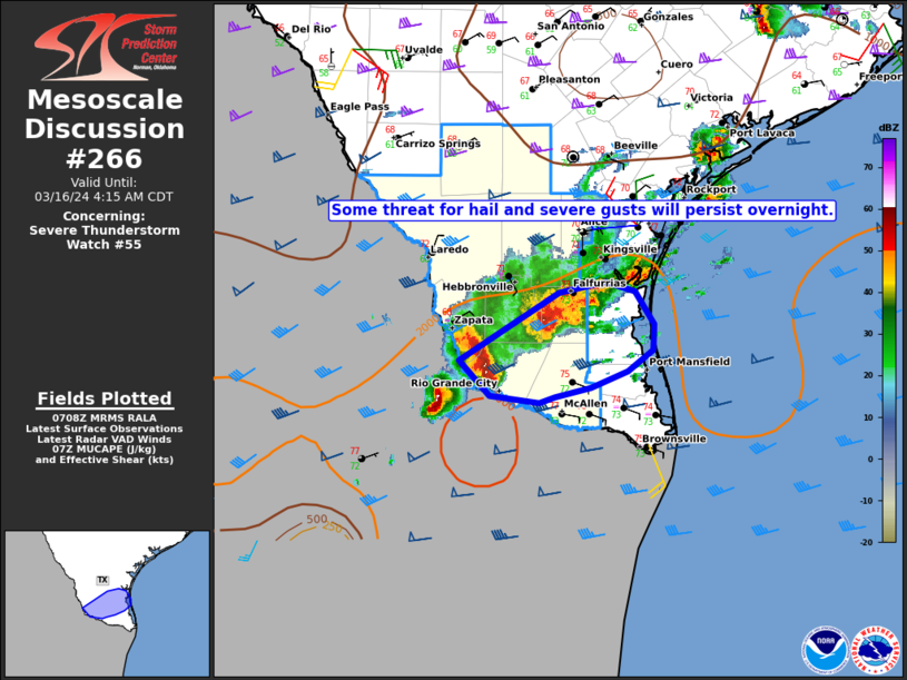
   Mesoscale Discussion 0266
   NWS Storm Prediction Center Norman OK
   0211 AM CDT Sat Mar 16 2024

   Areas affected...Parts of Deep South TX

   Concerning...Severe Thunderstorm Watch 55...

   Valid 160711Z - 160915Z

   The severe weather threat for Severe Thunderstorm Watch 55
   continues.

   SUMMARY...Some threat for hail and isolated severe gusts will
   persist overnight. Local watch extension may be needed.

   DISCUSSION...A supercell cluster over Deep South TX has shown
   gradual signs of upscale growth early this morning. A supercell over
   Starr County has recently accelerated eastward, while an earlier
   supercell has nearly stalled over Brooks County. The merger of these
   cells and their respective cold pools could result in a
   forward-propagating complex that approaches the coast later this
   morning.

   Flow is generally rather weak below 6 km AGL, but upper-level flow
   is sufficient to aid in maintaining some storm organization through
   the early morning. Steep midlevel lapse rates and MUCAPE in excess
   of 2000 J/kg will continue to support some hail threat for as long
   as semi-discrete storm mode is maintained. Strong to locally severe
   gusts will also be possible, especially if any additional upscale
   growth occurs. With WW 55 scheduled to expire at 08Z, local watch
   extension may need to be considered, depending on short-term
   convective trends.

   ..Dean/Thompson.. 03/16/2024

   ...Please see www.spc.noaa.gov for graphic product...

   ATTN...WFO...CRP...BRO...

   LAT...LON   26629920 27219825 27299781 27229752 26949735 26729736
               26539760 26399794 26329828 26269844 26329891 26629920
|
|
Top/All Mesoscale Discussions/Forecast Products/Home
|
|


 @NWSSPC