Note:
The expiration time in the watch graphic is amended if the watch is
replaced, cancelled or extended.
Note:
Note:
The expiration time in the watch graphic is amended if the watch is
replaced, cancelled or extended.
Note: Click for
Watch Status Reports.
SEL4
URGENT - IMMEDIATE BROADCAST REQUESTED
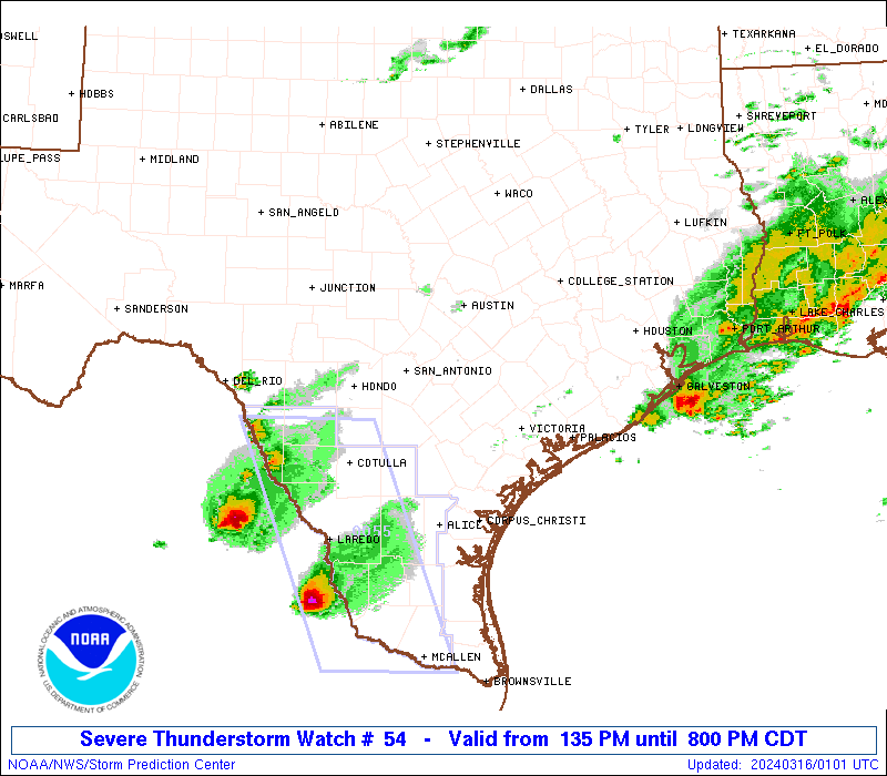
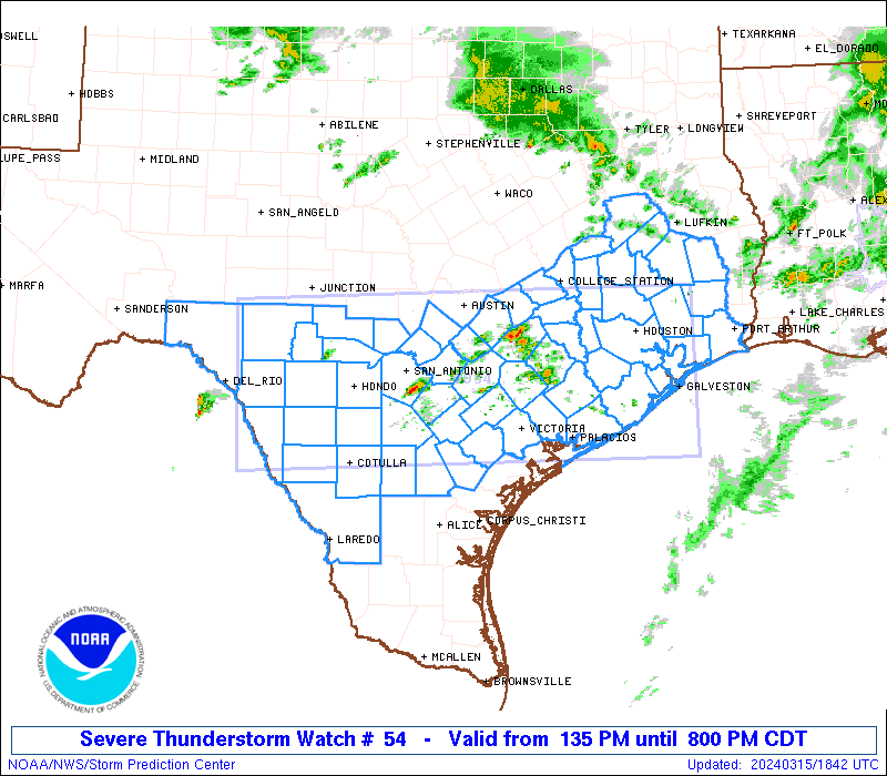
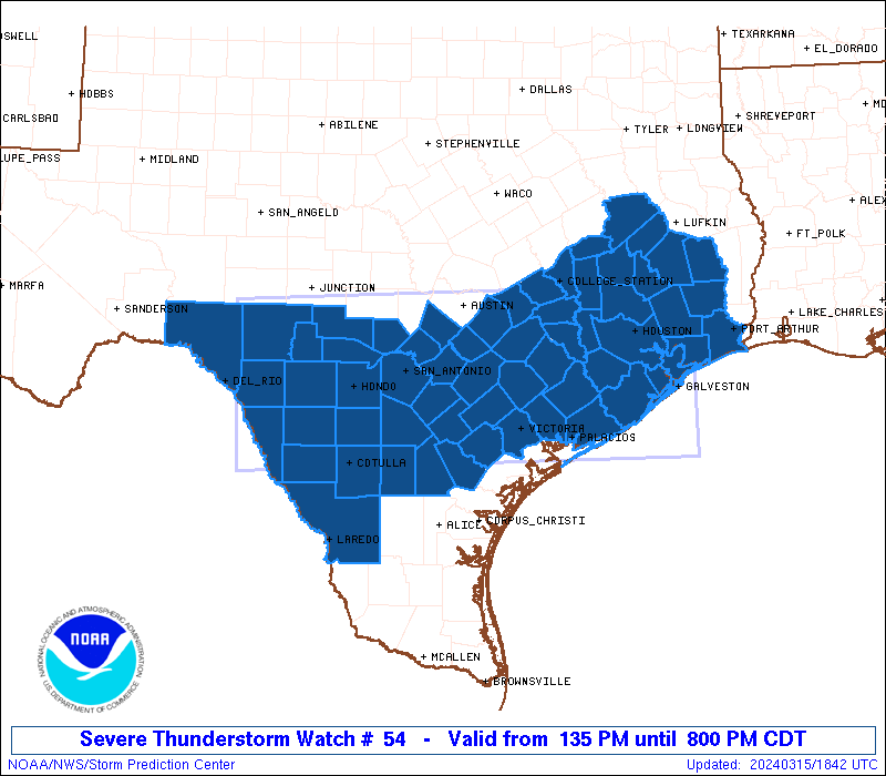
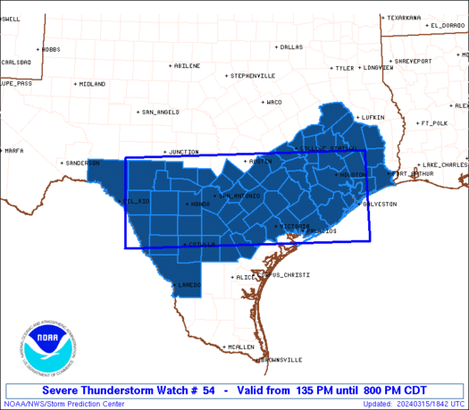
Severe Thunderstorm Watch Number 54
NWS Storm Prediction Center Norman OK
135 PM CDT Fri Mar 15 2024
The NWS Storm Prediction Center has issued a
* Severe Thunderstorm Watch for portions of
southern and southeastern Texas
Coastal Waters
* Effective this Friday afternoon and evening from 135 PM until
800 PM CDT.
* Primary threats include...
Widespread large hail likely with isolated very large hail
events to 3 inches in diameter possible
Scattered damaging wind gusts to 70 mph possible
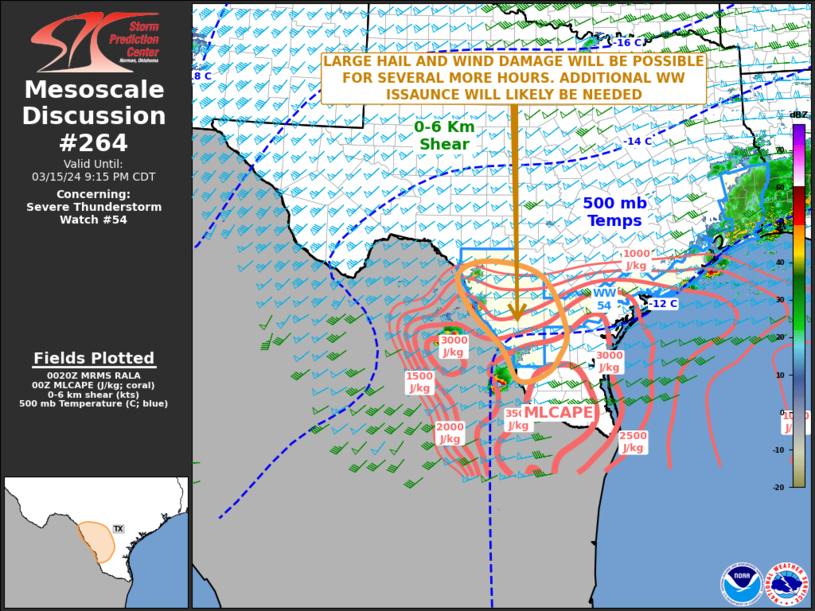
SUMMARY...Thunderstorms are expected to expand in coverage across
southern and eventually into southeastern Texas over the next few
hours. Very large hail will be possible with these storms, along
with potential for locally damaging wind gusts and perhaps a
tornado. Storms may linger into the evening, particularly across
western portions of the watch across the Rio Grande Valley vicinity.
The severe thunderstorm watch area is approximately along and 70
statute miles either side of a line from 95 miles west of Hondo TX
to 15 miles northeast of Galveston TX. For a complete depiction of
the watch see the associated watch outline update (WOUS64 KWNS
WOU4).
PRECAUTIONARY/PREPAREDNESS ACTIONS...
REMEMBER...A Severe Thunderstorm Watch means conditions are
favorable for severe thunderstorms in and close to the watch area.
Persons in these areas should be on the lookout for threatening
weather conditions and listen for later statements and possible
warnings. Severe thunderstorms can and occasionally do produce
tornadoes.
&&
OTHER WATCH INFORMATION...CONTINUE...WW 53...
AVIATION...A few severe thunderstorms with hail surface and aloft to
3 inches. Extreme turbulence and surface wind gusts to 60 knots. A
few cumulonimbi with maximum tops to 500. Mean storm motion vector
24035.
...Goss

   SEL4

   URGENT - IMMEDIATE BROADCAST REQUESTED
   Severe Thunderstorm Watch Number 54
   NWS Storm Prediction Center Norman OK
   135 PM CDT Fri Mar 15 2024

   The NWS Storm Prediction Center has issued a

   * Severe Thunderstorm Watch for portions of
     southern and southeastern Texas
     Coastal Waters

   * Effective this Friday afternoon and evening from 135 PM until
     800 PM CDT.

   * Primary threats include...
     Widespread large hail likely with isolated very large hail
       events to 3 inches in diameter possible
     Scattered damaging wind gusts to 70 mph possible

   SUMMARY...Thunderstorms are expected to expand in coverage across
   southern and eventually into southeastern Texas over the next few
   hours.  Very large hail will be possible with these storms, along
   with potential for locally damaging wind gusts and perhaps a
   tornado.  Storms may linger into the evening, particularly across
   western portions of the watch across the Rio Grande Valley vicinity.

   The severe thunderstorm watch area is approximately along and 70
   statute miles either side of a line from 95 miles west of Hondo TX
   to 15 miles northeast of Galveston TX. For a complete depiction of
   the watch see the associated watch outline update (WOUS64 KWNS
   WOU4).

   PRECAUTIONARY/PREPAREDNESS ACTIONS...

   REMEMBER...A Severe Thunderstorm Watch means conditions are
   favorable for severe thunderstorms in and close to the watch area.
   Persons in these areas should be on the lookout for threatening
   weather conditions and listen for later statements and possible
   warnings. Severe thunderstorms can and occasionally do produce
   tornadoes.

   &&

   OTHER WATCH INFORMATION...CONTINUE...WW 53...

   AVIATION...A few severe thunderstorms with hail surface and aloft to
   3 inches. Extreme turbulence and surface wind gusts to 60 knots. A
   few cumulonimbi with maximum tops to 500. Mean storm motion vector
   24035.

   ...Goss
 Note:
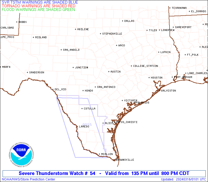
The Aviation Watch (SAW) product is an approximation to the watch area.
The actual watch is depicted by the shaded areas.
Note:
The Aviation Watch (SAW) product is an approximation to the watch area.
The actual watch is depicted by the shaded areas.
   SAW4
   WW 54 SEVERE TSTM TX CW 151835Z - 160100Z
   AXIS..70 STATUTE MILES EITHER SIDE OF LINE..
   95W HDO/HONDO TX/ - 15NE GLS/GALVESTON TX/
   ..AVIATION COORDS.. 60NM EITHER SIDE /1SSE DLF - 50SE IAH/
   HAIL SURFACE AND ALOFT..3 INCHES. WIND GUSTS..60 KNOTS.
   MAX TOPS TO 500. MEAN STORM MOTION VECTOR 24035.

   LAT...LON 30350082 30509463 28479451 28330070

   THIS IS AN APPROXIMATION TO THE WATCH AREA.  FOR A
   COMPLETE DEPICTION OF THE WATCH SEE WOUS64 KWNS
   FOR WOU4.
Watch 54 Status Report Messages:
STATUS REPORT #4 ON WW 54

VALID 160035Z - 160140Z

SEVERE WEATHER THREAT CONTINUES RIGHT OF A LINE FROM 15 S DRT TO
35 E DRT TO 5 WSW HDO TO 45 NE COT TO 35 NNW NIR TO 30 N VCT TO
30 N PSX TO 15 WSW HOU TO 25 W BPT.

..BROYLES..03/16/24

ATTN...WFO...EWX...HGX...CRP...LCH...

&&

STATUS REPORT FOR WS 54

SEVERE WEATHER THREAT CONTINUES FOR THE FOLLOWING AREAS

TXC025-039-071-127-163-167-175-239-245-283-297-311-321-323-361-
469-479-507-160140-

TX
.    TEXAS COUNTIES INCLUDED ARE

BEE		     BRAZORIA		 CHAMBERS
DIMMIT		     FRIO		 GALVESTON
GOLIAD		     JACKSON		 JEFFERSON
LA SALLE	     LIVE OAK		 MCMULLEN
MATAGORDA	     MAVERICK		 ORANGE
VICTORIA	     WEBB		 ZAVALA
$$


GMZ335-160140-

CW

.    ADJACENT COASTAL WATERS INCLUDED ARE

GALVESTON BAY

$$
THE WATCH STATUS MESSAGE IS FOR GUIDANCE PURPOSES ONLY.  PLEASE
REFER TO WATCH COUNTY NOTIFICATION STATEMENTS FOR OFFICIAL
INFORMATION ON COUNTIES...INDEPENDENT CITIES AND MARINE ZONES
CLEARED FROM SEVERE THUNDERSTORM AND TORNADO WATCHES.
$$

STATUS REPORT #3 ON WW 54

VALID 160000Z - 160140Z

SEVERE WEATHER THREAT CONTINUES RIGHT OF A LINE FROM 5 WNW DRT TO
45 SSE SAT TO 30 N PSX TO 30 W BPT.

..BROYLES..03/15/24

ATTN...WFO...EWX...HGX...CRP...LCH...

&&

STATUS REPORT FOR WS 54

SEVERE WEATHER THREAT CONTINUES FOR THE FOLLOWING AREAS

TXC013-025-039-071-127-163-167-175-239-245-255-283-297-311-321-
323-361-469-479-507-160140-

TX
.    TEXAS COUNTIES INCLUDED ARE

ATASCOSA	     BEE		 BRAZORIA
CHAMBERS	     DIMMIT		 FRIO
GALVESTON	     GOLIAD		 JACKSON
JEFFERSON	     KARNES		 LA SALLE
LIVE OAK	     MCMULLEN		 MATAGORDA
MAVERICK	     ORANGE		 VICTORIA
WEBB		     ZAVALA
$$


GMZ335-160140-

CW

.    ADJACENT COASTAL WATERS INCLUDED ARE

GALVESTON BAY

$$
THE WATCH STATUS MESSAGE IS FOR GUIDANCE PURPOSES ONLY.  PLEASE
REFER TO WATCH COUNTY NOTIFICATION STATEMENTS FOR OFFICIAL
INFORMATION ON COUNTIES...INDEPENDENT CITIES AND MARINE ZONES
CLEARED FROM SEVERE THUNDERSTORM AND TORNADO WATCHES.
$$

STATUS REPORT #2 ON WW 54

VALID 152230Z - 152340Z

SEVERE WEATHER THREAT CONTINUES RIGHT OF A LINE FROM 50 N DRT TO
45 SE JCT TO 20 ENE BAZ TO 40 SW CLL TO 15 NNE CLL.

..BROYLES..03/15/24

ATTN...WFO...EWX...HGX...CRP...LCH...

&&

STATUS REPORT FOR WS 54

SEVERE WEATHER THREAT CONTINUES FOR THE FOLLOWING AREAS

TXC013-015-019-025-029-039-041-071-089-091-123-127-137-149-157-
163-167-175-177-185-187-199-201-225-239-241-245-255-259-265-271-
283-285-291-297-311-313-321-323-325-339-351-361-373-385-407-455-
457-463-465-469-471-473-477-479-481-493-507-152340-

TX
.    TEXAS COUNTIES INCLUDED ARE

ATASCOSA	     AUSTIN		 BANDERA
BEE		     BEXAR		 BRAZORIA
BRAZOS		     CHAMBERS		 COLORADO
COMAL		     DEWITT		 DIMMIT
EDWARDS 	     FAYETTE		 FORT BEND
FRIO		     GALVESTON		 GOLIAD
GONZALES	     GRIMES		 GUADALUPE
HARDIN		     HARRIS		 HOUSTON
JACKSON 	     JASPER		 JEFFERSON
KARNES		     KENDALL		 KERR
KINNEY		     LA SALLE		 LAVACA
LIBERTY 	     LIVE OAK		 MCMULLEN
MADISON 	     MATAGORDA		 MAVERICK
MEDINA		     MONTGOMERY 	 NEWTON
ORANGE		     POLK		 REAL
SAN JACINTO	     TRINITY		 TYLER
UVALDE		     VAL VERDE		 VICTORIA
WALKER		     WALLER		 WASHINGTON
WEBB		     WHARTON		 WILSON
ZAVALA
$$


GMZ335-152340-

CW

.    ADJACENT COASTAL WATERS INCLUDED ARE

GALVESTON BAY

$$
THE WATCH STATUS MESSAGE IS FOR GUIDANCE PURPOSES ONLY.  PLEASE
REFER TO WATCH COUNTY NOTIFICATION STATEMENTS FOR OFFICIAL
INFORMATION ON COUNTIES...INDEPENDENT CITIES AND MARINE ZONES
CLEARED FROM SEVERE THUNDERSTORM AND TORNADO WATCHES.
$$

STATUS REPORT #1 ON WW 54

VALID 151945Z - 152040Z

THE SEVERE WEATHER THREAT CONTINUES ACROSS THE ENTIRE WATCH AREA.

FOR ADDITIONAL INFORMATION SEE MESOSCALE DISCUSSION 259

..WEINMAN..03/15/24

ATTN...WFO...EWX...HGX...CRP...LCH...

&&

STATUS REPORT FOR WS 54

SEVERE WEATHER THREAT CONTINUES FOR THE FOLLOWING AREAS

TXC013-015-019-021-025-029-039-041-051-055-071-089-091-123-127-
137-149-157-163-167-175-177-185-187-199-201-209-225-239-245-255-
259-265-271-283-285-287-291-297-311-313-321-323-325-339-373-385-
407-455-457-463-465-469-471-473-477-479-481-493-507-152040-

TX
.    TEXAS COUNTIES INCLUDED ARE

ATASCOSA	     AUSTIN		 BANDERA
BASTROP 	     BEE		 BEXAR
BRAZORIA	     BRAZOS		 BURLESON
CALDWELL	     CHAMBERS		 COLORADO
COMAL		     DEWITT		 DIMMIT
EDWARDS 	     FAYETTE		 FORT BEND
FRIO		     GALVESTON		 GOLIAD
GONZALES	     GRIMES		 GUADALUPE
HARDIN		     HARRIS		 HAYS
HOUSTON 	     JACKSON		 JEFFERSON
KARNES		     KENDALL		 KERR
KINNEY		     LA SALLE		 LAVACA
LEE		     LIBERTY		 LIVE OAK
MCMULLEN	     MADISON		 MATAGORDA
MAVERICK	     MEDINA		 MONTGOMERY
POLK		     REAL		 SAN JACINTO
TRINITY 	     TYLER		 UVALDE
VAL VERDE	     VICTORIA		 WALKER
WALLER		     WASHINGTON 	 WEBB
WHARTON 	     WILSON		 ZAVALA
$$


GMZ335-152040-

CW

.    ADJACENT COASTAL WATERS INCLUDED ARE

GALVESTON BAY

$$
THE WATCH STATUS MESSAGE IS FOR GUIDANCE PURPOSES ONLY.  PLEASE
REFER TO WATCH COUNTY NOTIFICATION STATEMENTS FOR OFFICIAL
INFORMATION ON COUNTIES...INDEPENDENT CITIES AND MARINE ZONES
CLEARED FROM SEVERE THUNDERSTORM AND TORNADO WATCHES.
$$
Note:
Click for Complete Product Text.
Tornadoes
Probability of 2 or more tornadoes
|
Low (10%)
|
Probability of 1 or more strong (EF2-EF5) tornadoes
|
Low (<2%)
|
Wind
Probability of 10 or more severe wind events
|
Mod (50%)
|
Probability of 1 or more wind events > 65 knots
|
Low (20%)
|
Hail
Probability of 10 or more severe hail events
|
High (80%)
|
Probability of 1 or more hailstones > 2 inches
|
Mod (50%)
|
Combined Severe Hail/Wind
Probability of 6 or more combined severe hail/wind events
|
High (>95%)
|
For each watch, probabilities for particular events inside the watch
(listed above in each table) are determined by the issuing forecaster.
The "Low" category contains probability values ranging from less than 2%
to 20% (EF2-EF5 tornadoes), less than 5% to 20% (all other probabilities),
"Moderate" from 30% to 60%, and "High" from 70% to greater than 95%.
High values are bolded and lighter in color to provide awareness of
an increased threat for a particular event.


 @NWSSPC