|
| Mesoscale Discussion 548 |
|
< Previous MD Next MD >
|
|
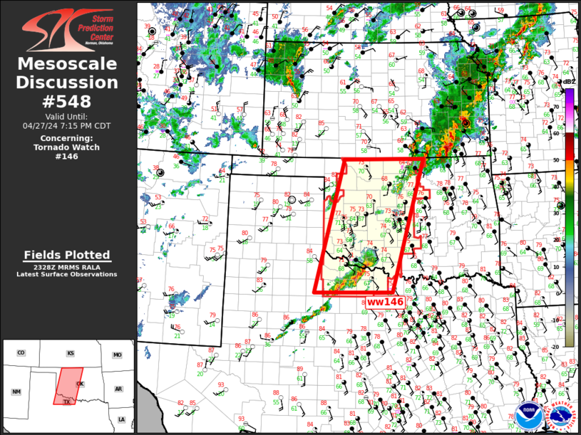
   Mesoscale Discussion 0548
   NWS Storm Prediction Center Norman OK
   0630 PM CDT Sat Apr 27 2024

   Areas affected...Southern Plains

   Concerning...Tornado Watch 146...

   Valid 272330Z - 280015Z

   CORRECTED FOR TORNADO WATCH

   The severe weather threat for Tornado Watch 146 continues.

   SUMMARY...Severe threat continues across western/central Oklahoma
   into northwest Texas.

   DISCUSSION...Latest satellite imagery suggests large-scale ascent is
   gradually spreading east across the southern High Plains, per
   thickening mid-high cloudiness noted into the TX Panhandle. Later
   this evening the mid-level speed max will round the base of the
   trough and translate into southwest OK. LLJ will strengthen ahead of
   this feature along the I35 corridor along with low-level shear.

   Southwest-northeast oriented corridor of convection, currently
   observed from northwest TX into southwest OK, may not move
   appreciably east over the next few hours until large-scale forcing
   shunts this region downstream later tonight. Upscale growth may
   occur as the aforementioned jet approaches in conjunction with the
   LLJ. Environmental parameters continue to favor supercells, and
   tornadoes, but some of this activity may exhibit linear
   characteristics along with clustering.

   Overall, severe threat is expected to linger well into the overnight
   hours with a gradual shift east later this evening.

   ..Darrow.. 04/27/2024

   ...Please see www.spc.noaa.gov for graphic product...

   ATTN...WFO...TSA...FWD...OUN...LUB...

   LAT...LON   33480027 36959934 36979680 33509783 33480027
|
|
Top/All Mesoscale Discussions/Forecast Products/Home
|
|


 @NWSSPC