Note:
The expiration time in the watch graphic is amended if the watch is
replaced, cancelled or extended.
Note:
Note:
The expiration time in the watch graphic is amended if the watch is
replaced, cancelled or extended.
Note: Click for
Watch Status Reports.
SEL9
URGENT - IMMEDIATE BROADCAST REQUESTED
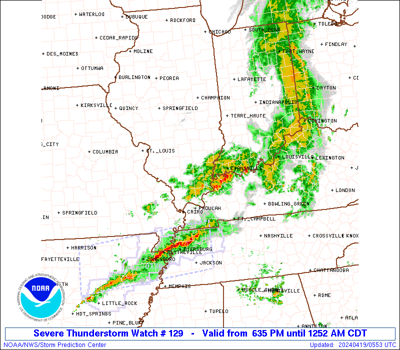
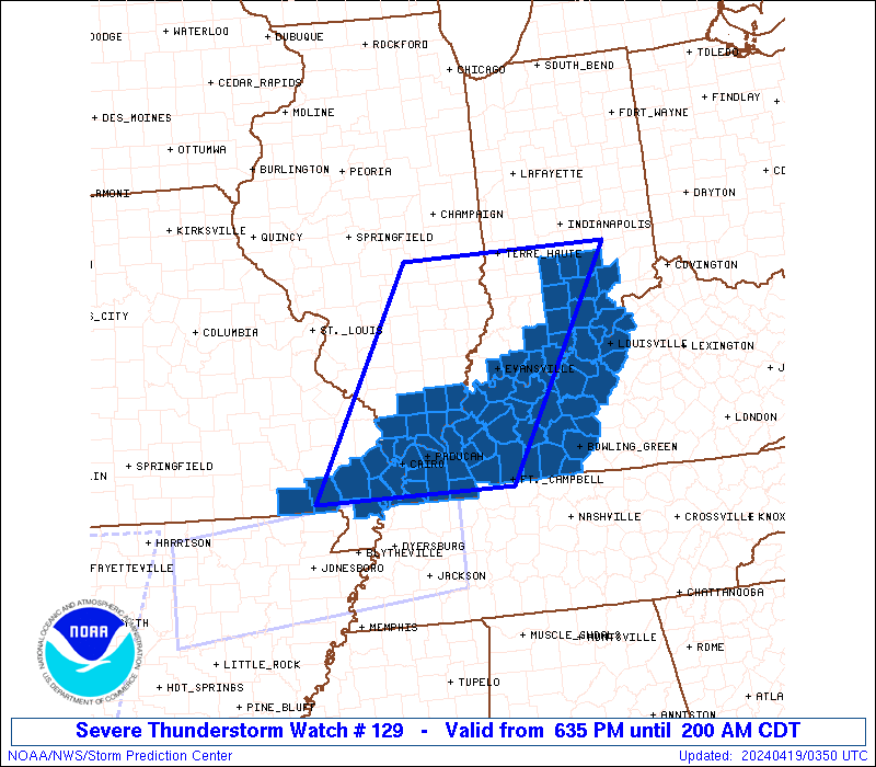
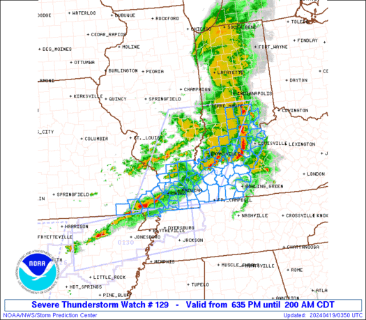
Severe Thunderstorm Watch Number 129
NWS Storm Prediction Center Norman OK
635 PM CDT Thu Apr 18 2024
The NWS Storm Prediction Center has issued a
* Severe Thunderstorm Watch for portions of
Southern Illinois
Southwest Indiana
Western Kentucky
Southeast Missouri
* Effective this Thursday night and Friday morning from 635 PM
until 200 AM CDT.
* Primary threats include...
Scattered damaging wind gusts to 70 mph likely
Isolated large hail events to 1.5 inches in diameter possible
A tornado or two possible
SUMMARY...Severe storms will continue to steadily move eastward
across the region, initially across southern Illinois and southeast
Missouri, reaching southwest Indiana/western Kentucky by mid to late
evening.
The severe thunderstorm watch area is approximately along and 85
statute miles east and west of a line from 35 miles south southwest
of Paducah KY to 5 miles east northeast of Terre Haute IN. For a
complete depiction of the watch see the associated watch outline
update (WOUS64 KWNS WOU9).
PRECAUTIONARY/PREPAREDNESS ACTIONS...
REMEMBER...A Severe Thunderstorm Watch means conditions are
favorable for severe thunderstorms in and close to the watch area.
Persons in these areas should be on the lookout for threatening
weather conditions and listen for later statements and possible
warnings. Severe thunderstorms can and occasionally do produce
tornadoes.
&&
OTHER WATCH INFORMATION...CONTINUE...WW 125...WW 126...WW
127...WW 128...
AVIATION...A few severe thunderstorms with hail surface and aloft to
1.5 inches. Extreme turbulence and surface wind gusts to 60 knots. A
few cumulonimbi with maximum tops to 500. Mean storm motion vector
27035.
...Guyer
   SEL9

   URGENT - IMMEDIATE BROADCAST REQUESTED
   Severe Thunderstorm Watch Number 129
   NWS Storm Prediction Center Norman OK
   635 PM CDT Thu Apr 18 2024

   The NWS Storm Prediction Center has issued a

   * Severe Thunderstorm Watch for portions of
     Southern Illinois
     Southwest Indiana
     Western Kentucky
     Southeast Missouri

   * Effective this Thursday night and Friday morning from 635 PM
     until 200 AM CDT.

   * Primary threats include...
     Scattered damaging wind gusts to 70 mph likely
     Isolated large hail events to 1.5 inches in diameter possible
     A tornado or two possible

   SUMMARY...Severe storms will continue to steadily move eastward
   across the region, initially across southern Illinois and southeast
   Missouri, reaching southwest Indiana/western Kentucky by mid to late
   evening.

   The severe thunderstorm watch area is approximately along and 85
   statute miles east and west of a line from 35 miles south southwest
   of Paducah KY to 5 miles east northeast of Terre Haute IN. For a
   complete depiction of the watch see the associated watch outline
   update (WOUS64 KWNS WOU9).

   PRECAUTIONARY/PREPAREDNESS ACTIONS...

   REMEMBER...A Severe Thunderstorm Watch means conditions are
   favorable for severe thunderstorms in and close to the watch area.
   Persons in these areas should be on the lookout for threatening
   weather conditions and listen for later statements and possible
   warnings. Severe thunderstorms can and occasionally do produce
   tornadoes.

   &&

   OTHER WATCH INFORMATION...CONTINUE...WW 125...WW 126...WW
   127...WW 128...

   AVIATION...A few severe thunderstorms with hail surface and aloft to
   1.5 inches. Extreme turbulence and surface wind gusts to 60 knots. A
   few cumulonimbi with maximum tops to 500. Mean storm motion vector
   27035.

   ...Guyer
 Note:
The Aviation Watch (SAW) product is an approximation to the watch area.
The actual watch is depicted by the shaded areas.
Note:
The Aviation Watch (SAW) product is an approximation to the watch area.
The actual watch is depicted by the shaded areas.
   SAW9
   WW 129 SEVERE TSTM IL IN KY MO 182335Z - 190700Z
   AXIS..85 STATUTE MILES EAST AND WEST OF LINE..
   35SSW PAH/PADUCAH KY/ - 5ENE HUF/TERRE HAUTE IN/
   ..AVIATION COORDS.. 75NM E/W /38NNE DYR - 1SE TTH/
   HAIL SURFACE AND ALOFT..1.5 INCHES. WIND GUSTS..60 KNOTS.
   MAX TOPS TO 500. MEAN STORM MOTION VECTOR 27035.

   LAT...LON 36599054 39478883 39478564 36598748

   THIS IS AN APPROXIMATION TO THE WATCH AREA.  FOR A
   COMPLETE DEPICTION OF THE WATCH SEE WOUS64 KWNS
   FOR WOU9.
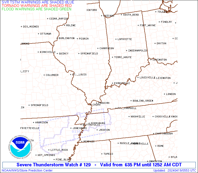
Watch 129 Status Report Messages:
STATUS REPORT #5 ON WW 129

VALID 190530Z - 190640Z

SEVERE WEATHER THREAT CONTINUES RIGHT OF A LINE FROM 35 NNW DYR
TO 35 NNW HOP TO 25 SE OWB.

..KERR..04/19/24

ATTN...WFO...PAH...ILX...IND...LMK...

&&

STATUS REPORT FOR WS 129

SEVERE WEATHER THREAT CONTINUES FOR THE FOLLOWING AREAS

KYC031-035-047-061-075-083-085-093-105-141-143-157-177-183-213-
219-221-227-190640-

KY
.    KENTUCKY COUNTIES INCLUDED ARE

BUTLER		     CALLOWAY		 CHRISTIAN
EDMONSON	     FULTON		 GRAVES
GRAYSON 	     HARDIN		 HICKMAN
LOGAN		     LYON		 MARSHALL
MUHLENBERG	     OHIO		 SIMPSON
TODD		     TRIGG		 WARREN
$$


THE WATCH STATUS MESSAGE IS FOR GUIDANCE PURPOSES ONLY.  PLEASE
REFER TO WATCH COUNTY NOTIFICATION STATEMENTS FOR OFFICIAL
INFORMATION ON COUNTIES...INDEPENDENT CITIES AND MARINE ZONES
CLEARED FROM SEVERE THUNDERSTORM AND TORNADO WATCHES.
$$

STATUS REPORT #4 ON WW 129

VALID 190450Z - 190540Z

SEVERE WEATHER THREAT CONTINUES RIGHT OF A LINE FROM 20 S POF TO
5 SSE MDH TO 10 W EVV TO 20 NW SDF TO 50 W LUK.

FOR ADDITIONAL INFORMATION SEE MESOSCALE DISCUSSION 491

..DEAN..04/19/24

ATTN...WFO...PAH...ILX...IND...LMK...

&&

STATUS REPORT FOR WS 129

SEVERE WEATHER THREAT CONTINUES FOR THE FOLLOWING AREAS

ILC003-059-069-087-127-151-153-165-181-199-190540-

IL
.    ILLINOIS COUNTIES INCLUDED ARE

ALEXANDER	     GALLATIN		 HARDIN
JOHNSON 	     MASSAC		 POPE
PULASKI 	     SALINE		 UNION
WILLIAMSON
$$


INC019-043-061-123-143-147-163-173-190540-

IN
.    INDIANA COUNTIES INCLUDED ARE

CLARK		     FLOYD		 HARRISON
PERRY		     SCOTT		 SPENCER
VANDERBURGH	     WARRICK
$$


KYC007-027-029-031-033-035-039-047-055-059-061-075-083-085-091-
093-101-105-107-111-139-141-143-145-149-157-163-177-183-185-213-
219-221-225-227-233-190540-

KY
.    KENTUCKY COUNTIES INCLUDED ARE

BALLARD 	     BRECKINRIDGE	 BULLITT
BUTLER		     CALDWELL		 CALLOWAY
CARLISLE	     CHRISTIAN		 CRITTENDEN
DAVIESS 	     EDMONSON		 FULTON
GRAVES		     GRAYSON		 HANCOCK
HARDIN		     HENDERSON		 HICKMAN
HOPKINS 	     JEFFERSON		 LIVINGSTON
LOGAN		     LYON		 MCCRACKEN
MCLEAN		     MARSHALL		 MEADE
MUHLENBERG	     OHIO		 OLDHAM
SIMPSON 	     TODD		 TRIGG
UNION		     WARREN		 WEBSTER
$$


MOC133-143-201-207-190540-

MO
.    MISSOURI COUNTIES INCLUDED ARE

MISSISSIPPI	     NEW MADRID 	 SCOTT
STODDARD
$$


THE WATCH STATUS MESSAGE IS FOR GUIDANCE PURPOSES ONLY.  PLEASE
REFER TO WATCH COUNTY NOTIFICATION STATEMENTS FOR OFFICIAL
INFORMATION ON COUNTIES...INDEPENDENT CITIES AND MARINE ZONES
CLEARED FROM SEVERE THUNDERSTORM AND TORNADO WATCHES.
$$

STATUS REPORT #3 ON WW 129

VALID 190325Z - 190440Z

SEVERE WEATHER THREAT CONTINUES RIGHT OF A LINE FROM 25 SSW FAM
TO 30 SSE MVN TO 40 ENE EVV TO 15 NNW IND.

..DEAN..04/19/24

ATTN...WFO...PAH...ILX...IND...LMK...

&&

STATUS REPORT FOR WS 129

SEVERE WEATHER THREAT CONTINUES FOR THE FOLLOWING AREAS

ILC003-059-069-087-127-151-153-165-181-199-190440-

IL
.    ILLINOIS COUNTIES INCLUDED ARE

ALEXANDER	     GALLATIN		 HARDIN
JOHNSON 	     MASSAC		 POPE
PULASKI 	     SALINE		 UNION
WILLIAMSON
$$


INC005-013-019-025-043-061-071-079-093-117-123-143-147-163-173-
175-190440-

IN
.    INDIANA COUNTIES INCLUDED ARE

BARTHOLOMEW	     BROWN		 CLARK
CRAWFORD	     FLOYD		 HARRISON
JACKSON 	     JENNINGS		 LAWRENCE
ORANGE		     PERRY		 SCOTT
SPENCER 	     VANDERBURGH	 WARRICK
WASHINGTON
$$


KYC007-027-029-031-033-035-039-047-055-059-061-075-083-085-091-
093-101-105-107-111-139-141-143-145-149-157-163-177-183-185-213-
219-221-225-227-233-190440-

KY
.    KENTUCKY COUNTIES INCLUDED ARE

BALLARD 	     BRECKINRIDGE	 BULLITT
BUTLER		     CALDWELL		 CALLOWAY
CARLISLE	     CHRISTIAN		 CRITTENDEN
DAVIESS 	     EDMONSON		 FULTON
GRAVES		     GRAYSON		 HANCOCK
HARDIN		     HENDERSON		 HICKMAN
HOPKINS 	     JEFFERSON		 LIVINGSTON
LOGAN		     LYON		 MCCRACKEN
MCLEAN		     MARSHALL		 MEADE
MUHLENBERG	     OHIO		 OLDHAM
SIMPSON 	     TODD		 TRIGG
UNION		     WARREN		 WEBSTER
$$


MOC023-133-143-181-201-207-190440-

MO
.    MISSOURI COUNTIES INCLUDED ARE

BUTLER		     MISSISSIPPI	 NEW MADRID
RIPLEY		     SCOTT		 STODDARD
$$


THE WATCH STATUS MESSAGE IS FOR GUIDANCE PURPOSES ONLY.  PLEASE
REFER TO WATCH COUNTY NOTIFICATION STATEMENTS FOR OFFICIAL
INFORMATION ON COUNTIES...INDEPENDENT CITIES AND MARINE ZONES
CLEARED FROM SEVERE THUNDERSTORM AND TORNADO WATCHES.
$$

STATUS REPORT #2 ON WW 129

VALID 190210Z - 190340Z

SEVERE WEATHER THREAT CONTINUES RIGHT OF A LINE FROM 10 SE FAM TO
40 NW EVV TO 20 SW HUF TO 25 NNW HUF.

..DEAN..04/19/24

ATTN...WFO...PAH...ILX...IND...LMK...

&&

STATUS REPORT FOR WS 129

SEVERE WEATHER THREAT CONTINUES FOR THE FOLLOWING AREAS

ILC003-045-055-059-065-069-077-087-127-151-153-165-181-193-199-
190340-

IL
.    ILLINOIS COUNTIES INCLUDED ARE

ALEXANDER	     EDGAR		 FRANKLIN
GALLATIN	     HAMILTON		 HARDIN
JACKSON 	     JOHNSON		 MASSAC
POPE		     PULASKI		 SALINE
UNION		     WHITE		 WILLIAMSON
$$


INC021-025-027-037-051-055-083-093-101-105-117-119-123-125-129-
147-153-163-167-173-190340-

IN
.    INDIANA COUNTIES INCLUDED ARE

CLAY		     CRAWFORD		 DAVIESS
DUBOIS		     GIBSON		 GREENE
KNOX		     LAWRENCE		 MARTIN
MONROE		     ORANGE		 OWEN
PERRY		     PIKE		 POSEY
SPENCER 	     SULLIVAN		 VANDERBURGH
VIGO		     WARRICK
$$


KYC007-027-031-033-035-039-047-055-059-061-075-083-085-091-101-
105-107-139-141-143-145-149-157-163-177-183-213-219-221-225-227-
233-190340-

KY
.    KENTUCKY COUNTIES INCLUDED ARE

BALLARD 	     BRECKINRIDGE	 BUTLER
CALDWELL	     CALLOWAY		 CARLISLE
CHRISTIAN	     CRITTENDEN 	 DAVIESS
EDMONSON	     FULTON		 GRAVES
GRAYSON 	     HANCOCK		 HENDERSON
HICKMAN 	     HOPKINS		 LIVINGSTON
LOGAN		     LYON		 MCCRACKEN
MCLEAN		     MARSHALL		 MEADE
MUHLENBERG	     OHIO		 SIMPSON
TODD		     TRIGG		 UNION
WARREN		     WEBSTER
$$


MOC017-023-031-035-133-143-157-181-201-207-223-190340-

MO
.    MISSOURI COUNTIES INCLUDED ARE

BOLLINGER	     BUTLER		 CAPE GIRARDEAU
CARTER		     MISSISSIPPI	 NEW MADRID
PERRY		     RIPLEY		 SCOTT
STODDARD	     WAYNE
$$


THE WATCH STATUS MESSAGE IS FOR GUIDANCE PURPOSES ONLY.  PLEASE
REFER TO WATCH COUNTY NOTIFICATION STATEMENTS FOR OFFICIAL
INFORMATION ON COUNTIES...INDEPENDENT CITIES AND MARINE ZONES
CLEARED FROM SEVERE THUNDERSTORM AND TORNADO WATCHES.
$$

STATUS REPORT #1 ON WW 129

VALID 190040Z - 190140Z

THE SEVERE WEATHER THREAT CONTINUES ACROSS THE ENTIRE WATCH AREA.

FOR ADDITIONAL INFORMATION SEE MESOSCALE DISCUSSION 488

..THORNTON..04/19/24

ATTN...WFO...PAH...ILX...IND...LMK...

&&

STATUS REPORT FOR WS 129

SEVERE WEATHER THREAT CONTINUES FOR THE FOLLOWING AREAS

ILC003-023-029-033-035-045-047-055-059-065-069-077-079-081-087-
101-127-145-151-153-159-165-181-185-191-193-199-190140-

IL
.    ILLINOIS COUNTIES INCLUDED ARE

ALEXANDER	     CLARK		 COLES
CRAWFORD	     CUMBERLAND 	 EDGAR
EDWARDS 	     FRANKLIN		 GALLATIN
HAMILTON	     HARDIN		 JACKSON
JASPER		     JEFFERSON		 JOHNSON
LAWRENCE	     MASSAC		 PERRY
POPE		     PULASKI		 RICHLAND
SALINE		     UNION		 WABASH
WAYNE		     WHITE		 WILLIAMSON
$$


INC021-025-027-037-051-055-083-093-101-105-117-119-123-125-129-
147-153-163-167-173-190140-

IN
.    INDIANA COUNTIES INCLUDED ARE

CLAY		     CRAWFORD		 DAVIESS
DUBOIS		     GIBSON		 GREENE
KNOX		     LAWRENCE		 MARTIN
MONROE		     ORANGE		 OWEN
PERRY		     PIKE		 POSEY
SPENCER 	     SULLIVAN		 VANDERBURGH
VIGO		     WARRICK
$$


KYC007-027-031-033-035-039-047-055-059-061-075-083-085-091-101-
105-107-139-141-143-145-149-157-163-177-183-213-219-221-225-227-
233-190140-

KY
.    KENTUCKY COUNTIES INCLUDED ARE

BALLARD 	     BRECKINRIDGE	 BUTLER
CALDWELL	     CALLOWAY		 CARLISLE
CHRISTIAN	     CRITTENDEN 	 DAVIESS
EDMONSON	     FULTON		 GRAVES
GRAYSON 	     HANCOCK		 HENDERSON
HICKMAN 	     HOPKINS		 LIVINGSTON
LOGAN		     LYON		 MCCRACKEN
MCLEAN		     MARSHALL		 MEADE
MUHLENBERG	     OHIO		 SIMPSON
TODD		     TRIGG		 UNION
WARREN		     WEBSTER
$$


MOC017-023-031-035-133-143-157-181-201-207-223-190140-

MO
.    MISSOURI COUNTIES INCLUDED ARE

BOLLINGER	     BUTLER		 CAPE GIRARDEAU
CARTER		     MISSISSIPPI	 NEW MADRID
PERRY		     RIPLEY		 SCOTT
STODDARD	     WAYNE
$$


THE WATCH STATUS MESSAGE IS FOR GUIDANCE PURPOSES ONLY.  PLEASE
REFER TO WATCH COUNTY NOTIFICATION STATEMENTS FOR OFFICIAL
INFORMATION ON COUNTIES...INDEPENDENT CITIES AND MARINE ZONES
CLEARED FROM SEVERE THUNDERSTORM AND TORNADO WATCHES.
$$
Note:
Click for Complete Product Text.
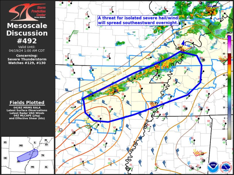
Tornadoes
Probability of 2 or more tornadoes
|
Low (20%)
|
Probability of 1 or more strong (EF2-EF5) tornadoes
|
Low (20%)
|
Wind
Probability of 10 or more severe wind events
|
Mod (60%)
|
Probability of 1 or more wind events > 65 knots
|
Low (20%)
|
Hail
Probability of 10 or more severe hail events
|
Low (20%)
|
Probability of 1 or more hailstones > 2 inches
|
Low (10%)
|
Combined Severe Hail/Wind
Probability of 6 or more combined severe hail/wind events
|
High (90%)
|
For each watch, probabilities for particular events inside the watch
(listed above in each table) are determined by the issuing forecaster.
The "Low" category contains probability values ranging from less than 2%
to 20% (EF2-EF5 tornadoes), less than 5% to 20% (all other probabilities),
"Moderate" from 30% to 60%, and "High" from 70% to greater than 95%.
High values are bolded and lighter in color to provide awareness of
an increased threat for a particular event.


 @NWSSPC