 Note:
The expiration time in the watch graphic is amended if the watch is
replaced, cancelled or extended.
Note:
Note:
The expiration time in the watch graphic is amended if the watch is
replaced, cancelled or extended.
Note: Click for
Watch Status Reports.
SEL7
URGENT - IMMEDIATE BROADCAST REQUESTED
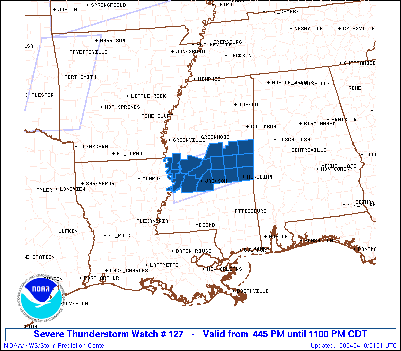
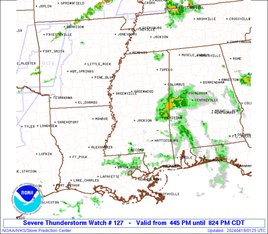
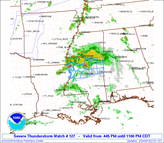
Severe Thunderstorm Watch Number 127
NWS Storm Prediction Center Norman OK
445 PM CDT Thu Apr 18 2024
The NWS Storm Prediction Center has issued a
* Severe Thunderstorm Watch for portions of
Central Mississippi
* Effective this Thursday afternoon and evening from 445 PM until
1100 PM CDT.
* Primary threats include...
Scattered damaging wind gusts to 65 mph possible
Scattered large hail events to 1.5 inches in diameter possible
SUMMARY...Strong to severe thunderstorms should focus across central
Mississippi through the late afternoon and early evening hours, with
severe hail and damaging winds as the main hazards.
The severe thunderstorm watch area is approximately along and 35
statute miles north and south of a line from 130 miles west of
Meridian MS to 35 miles north northeast of Meridian MS. For a
complete depiction of the watch see the associated watch outline
update (WOUS64 KWNS WOU7).
PRECAUTIONARY/PREPAREDNESS ACTIONS...
REMEMBER...A Severe Thunderstorm Watch means conditions are
favorable for severe thunderstorms in and close to the watch area.
Persons in these areas should be on the lookout for threatening
weather conditions and listen for later statements and possible
warnings. Severe thunderstorms can and occasionally do produce
tornadoes.
&&
OTHER WATCH INFORMATION...CONTINUE...WW 125...WW 126...
AVIATION...A few severe thunderstorms with hail surface and aloft to
1.5 inches. Extreme turbulence and surface wind gusts to 55 knots. A
few cumulonimbi with maximum tops to 500. Mean storm motion vector
28025.
...Guyer
   SEL7

   URGENT - IMMEDIATE BROADCAST REQUESTED
   Severe Thunderstorm Watch Number 127
   NWS Storm Prediction Center Norman OK
   445 PM CDT Thu Apr 18 2024

   The NWS Storm Prediction Center has issued a

   * Severe Thunderstorm Watch for portions of
     Central Mississippi

   * Effective this Thursday afternoon and evening from 445 PM until
     1100 PM CDT.

   * Primary threats include...
     Scattered damaging wind gusts to 65 mph possible
     Scattered large hail events to 1.5 inches in diameter possible

   SUMMARY...Strong to severe thunderstorms should focus across central
   Mississippi through the late afternoon and early evening hours, with
   severe hail and damaging winds as the main hazards.

   The severe thunderstorm watch area is approximately along and 35
   statute miles north and south of a line from 130 miles west of
   Meridian MS to 35 miles north northeast of Meridian MS. For a
   complete depiction of the watch see the associated watch outline
   update (WOUS64 KWNS WOU7).

   PRECAUTIONARY/PREPAREDNESS ACTIONS...

   REMEMBER...A Severe Thunderstorm Watch means conditions are
   favorable for severe thunderstorms in and close to the watch area.
   Persons in these areas should be on the lookout for threatening
   weather conditions and listen for later statements and possible
   warnings. Severe thunderstorms can and occasionally do produce
   tornadoes.

   &&

   OTHER WATCH INFORMATION...CONTINUE...WW 125...WW 126...

   AVIATION...A few severe thunderstorms with hail surface and aloft to
   1.5 inches. Extreme turbulence and surface wind gusts to 55 knots. A
   few cumulonimbi with maximum tops to 500. Mean storm motion vector
   28025.

   ...Guyer
 Note:
The Aviation Watch (SAW) product is an approximation to the watch area.
The actual watch is depicted by the shaded areas.
Note:
The Aviation Watch (SAW) product is an approximation to the watch area.
The actual watch is depicted by the shaded areas.
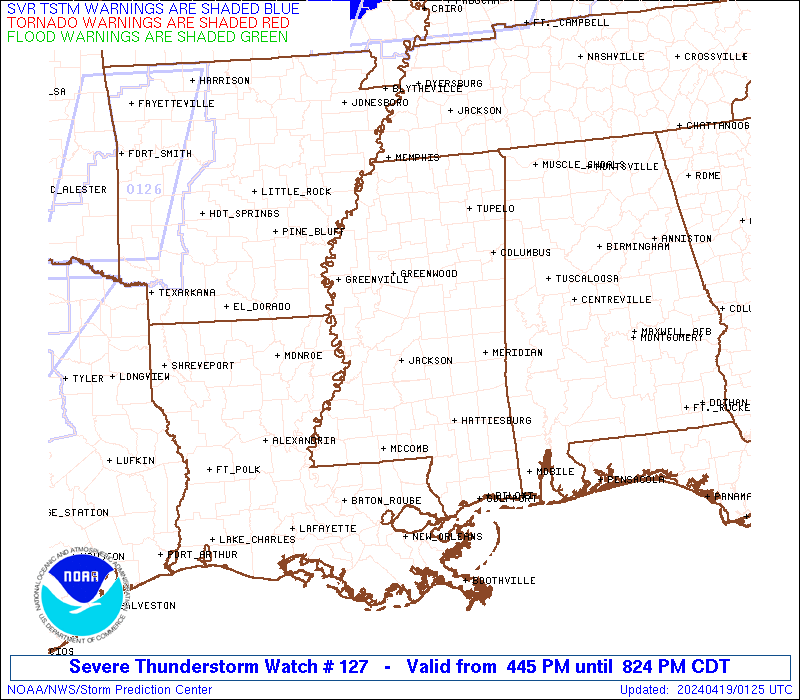
   SAW7
   WW 127 SEVERE TSTM MS 182145Z - 190400Z
   AXIS..35 STATUTE MILES NORTH AND SOUTH OF LINE..
   130W MEI/MERIDIAN MS/ - 35NNE MEI/MERIDIAN MS/
   ..AVIATION COORDS.. 30NM N/S /45W MHZ - 29NNE MEI/
   HAIL SURFACE AND ALOFT..1.5 INCHES. WIND GUSTS..55 KNOTS.
   MAX TOPS TO 500. MEAN STORM MOTION VECTOR 28025.

   LAT...LON 32829098 33308852 32298852 31809098

   THIS IS AN APPROXIMATION TO THE WATCH AREA.  FOR A
   COMPLETE DEPICTION OF THE WATCH SEE WOUS64 KWNS
   FOR WOU7.
Watch 127 Status Report Messages:
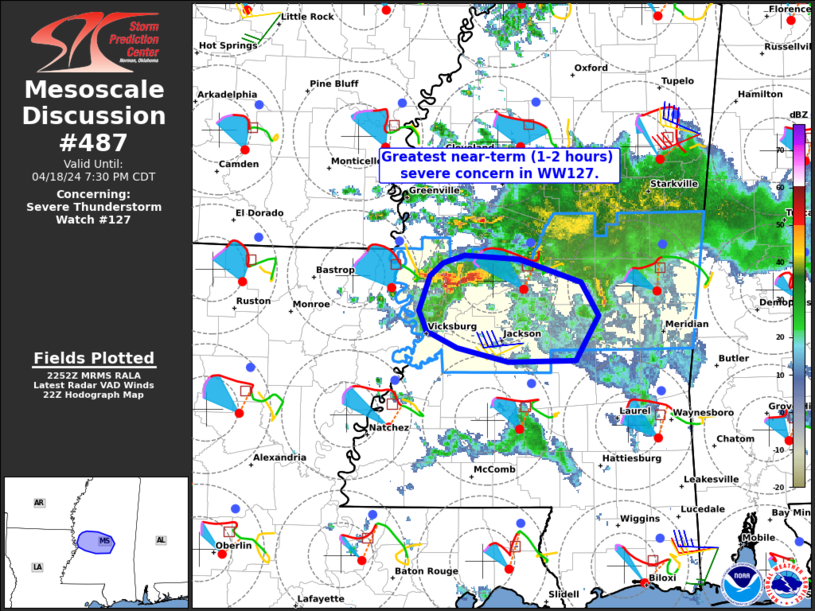
STATUS REPORT #3 ON WW 127

VALID 190035Z - 190140Z

SEVERE WEATHER THREAT CONTINUES RIGHT OF A LINE FROM 40 N MCB TO
35 ESE GWO.

..THORNTON..04/19/24

ATTN...WFO...JAN...

&&

STATUS REPORT FOR WS 127

SEVERE WEATHER THREAT CONTINUES FOR THE FOLLOWING AREAS

MSC069-075-079-099-101-103-121-123-159-190140-

MS
.    MISSISSIPPI COUNTIES INCLUDED ARE

KEMPER		     LAUDERDALE 	 LEAKE
NESHOBA 	     NEWTON		 NOXUBEE
RANKIN		     SCOTT		 WINSTON
$$


THE WATCH STATUS MESSAGE IS FOR GUIDANCE PURPOSES ONLY.  PLEASE
REFER TO WATCH COUNTY NOTIFICATION STATEMENTS FOR OFFICIAL
INFORMATION ON COUNTIES...INDEPENDENT CITIES AND MARINE ZONES
CLEARED FROM SEVERE THUNDERSTORM AND TORNADO WATCHES.
$$

STATUS REPORT #2 ON WW 127

VALID 182335Z - 190040Z

SEVERE WEATHER THREAT CONTINUES RIGHT OF A LINE FROM 15 NE HEZ TO
35 SW GWO.

..THORNTON..04/18/24

ATTN...WFO...JAN...

&&

STATUS REPORT FOR WS 127

SEVERE WEATHER THREAT CONTINUES FOR THE FOLLOWING AREAS

MSC007-049-069-075-079-089-099-101-103-121-123-159-163-190040-

MS
.    MISSISSIPPI COUNTIES INCLUDED ARE

ATTALA		     HINDS		 KEMPER
LAUDERDALE	     LEAKE		 MADISON
NESHOBA 	     NEWTON		 NOXUBEE
RANKIN		     SCOTT		 WINSTON
YAZOO
$$


THE WATCH STATUS MESSAGE IS FOR GUIDANCE PURPOSES ONLY.  PLEASE
REFER TO WATCH COUNTY NOTIFICATION STATEMENTS FOR OFFICIAL
INFORMATION ON COUNTIES...INDEPENDENT CITIES AND MARINE ZONES
CLEARED FROM SEVERE THUNDERSTORM AND TORNADO WATCHES.
$$

STATUS REPORT #1 ON WW 127

VALID 182240Z - 182340Z

THE SEVERE WEATHER THREAT CONTINUES ACROSS THE ENTIRE WATCH AREA.

..THORNTON..04/18/24

ATTN...WFO...JAN...

&&

STATUS REPORT FOR WS 127

SEVERE WEATHER THREAT CONTINUES FOR THE FOLLOWING AREAS

MSC007-049-055-069-075-079-089-099-101-103-121-123-125-149-159-
163-182340-

MS
.    MISSISSIPPI COUNTIES INCLUDED ARE

ATTALA		     HINDS		 ISSAQUENA
KEMPER		     LAUDERDALE 	 LEAKE
MADISON 	     NESHOBA		 NEWTON
NOXUBEE 	     RANKIN		 SCOTT
SHARKEY 	     WARREN		 WINSTON
YAZOO
$$


THE WATCH STATUS MESSAGE IS FOR GUIDANCE PURPOSES ONLY.  PLEASE
REFER TO WATCH COUNTY NOTIFICATION STATEMENTS FOR OFFICIAL
INFORMATION ON COUNTIES...INDEPENDENT CITIES AND MARINE ZONES
CLEARED FROM SEVERE THUNDERSTORM AND TORNADO WATCHES.
$$
Note:
Click for Complete Product Text.
Tornadoes
Probability of 2 or more tornadoes
|
Low (10%)
|
Probability of 1 or more strong (EF2-EF5) tornadoes
|
Low (5%)
|
Wind
Probability of 10 or more severe wind events
|
Mod (40%)
|
Probability of 1 or more wind events > 65 knots
|
Low (10%)
|
Hail
Probability of 10 or more severe hail events
|
Mod (40%)
|
Probability of 1 or more hailstones > 2 inches
|
Low (10%)
|
Combined Severe Hail/Wind
Probability of 6 or more combined severe hail/wind events
|
High (70%)
|
For each watch, probabilities for particular events inside the watch
(listed above in each table) are determined by the issuing forecaster.
The "Low" category contains probability values ranging from less than 2%
to 20% (EF2-EF5 tornadoes), less than 5% to 20% (all other probabilities),
"Moderate" from 30% to 60%, and "High" from 70% to greater than 95%.
High values are bolded and lighter in color to provide awareness of
an increased threat for a particular event.


 @NWSSPC