Note:
The expiration time in the watch graphic is amended if the watch is
replaced, cancelled or extended.
Note:
Note:
The expiration time in the watch graphic is amended if the watch is
replaced, cancelled or extended.
Note: Click for
Watch Status Reports.
   SEL8

   URGENT - IMMEDIATE BROADCAST REQUESTED
   Tornado Watch Number 18
   NWS Storm Prediction Center Norman OK
   900 AM CST Sun Feb 11 2024

   The NWS Storm Prediction Center has issued a

   * Tornado Watch for portions of
     Southeast Texas

   * Effective this Sunday morning and afternoon from 900 AM until
     300 PM CST.

   * Primary threats include...
     A couple tornadoes possible
     Scattered large hail and isolated very large hail events to 2.5
       inches in diameter possible
     Scattered damaging wind gusts to 70 mph possible

   SUMMARY...A few supercells are expected to spread eastward across
   southeast Texas through early afternoon along a surface cold front.
   The storm environment will favor isolated very large hail (up to 2.5
   inches in diameter), damaging winds to 70 mph, and a couple of
   tornadoes with these storms.

   The tornado watch area is approximately along and 35 statute miles
   north and south of a line from 35 miles south southwest of College
   Station TX to 110 miles east of Huntsville TX. For a complete
   depiction of the watch see the associated watch outline update
   (WOUS64 KWNS WOU8).

   PRECAUTIONARY/PREPAREDNESS ACTIONS...

   REMEMBER...A Tornado Watch means conditions are favorable for
   tornadoes and severe thunderstorms in and close to the watch
   area. Persons in these areas should be on the lookout for
   threatening weather conditions and listen for later statements
   and possible warnings.

   &&

   OTHER WATCH INFORMATION...CONTINUE...WW 16...WW 17...

   AVIATION...Tornadoes and a few severe thunderstorms with hail
   surface and aloft to 2.5 inches. Extreme turbulence and surface wind
   gusts to 60 knots. A few cumulonimbi with maximum tops to 500. Mean
   storm motion vector 26035.

   ...Thompson
 Note:
The Aviation Watch (SAW) product is an approximation to the watch area.
The actual watch is depicted by the shaded areas.
Note:
The Aviation Watch (SAW) product is an approximation to the watch area.
The actual watch is depicted by the shaded areas.
   SAW8
   WW 18 TORNADO TX 111500Z - 112100Z
   AXIS..35 STATUTE MILES NORTH AND SOUTH OF LINE..
   35SSW CLL/COLLEGE STATION TX/ - 110E UTS/HUNTSVILLE TX/
   ..AVIATION COORDS.. 30NM N/S /51ESE CWK - 43NW LCH/
   HAIL SURFACE AND ALOFT..2.5 INCHES. WIND GUSTS..60 KNOTS.
   MAX TOPS TO 500. MEAN STORM MOTION VECTOR 26035.

   LAT...LON 30629659 31229362 30219362 29619659

   THIS IS AN APPROXIMATION TO THE WATCH AREA.  FOR A
   COMPLETE DEPICTION OF THE WATCH SEE WOUS64 KWNS
   FOR WOU8.
Watch 18 Status Report Messages:
STATUS REPORT #5 ON WW 18
VALID 111940Z - 112040Z
SEVERE WEATHER THREAT CONTINUES RIGHT OF A LINE FROM 5 SSW HOU TO
50 SSW SHV.
..MOORE..02/11/24
ATTN...WFO...HGX...LCH...
&&
STATUS REPORT FOR WT 18
SEVERE WEATHER THREAT CONTINUES FOR THE FOLLOWING AREAS
TXC199-241-291-351-457-112040-
TX
. TEXAS COUNTIES INCLUDED ARE
HARDIN JASPER LIBERTY
NEWTON TYLER
$$
THE WATCH STATUS MESSAGE IS FOR GUIDANCE PURPOSES ONLY. PLEASE
REFER TO WATCH COUNTY NOTIFICATION STATEMENTS FOR OFFICIAL
INFORMATION ON COUNTIES...INDEPENDENT CITIES AND MARINE ZONES
CLEARED FROM SEVERE THUNDERSTORM AND TORNADO WATCHES.
$$
STATUS REPORT #4 ON WW 18
VALID 111835Z - 111940Z
SEVERE WEATHER THREAT CONTINUES RIGHT OF A LINE FROM 30 WSW HOU
TO 30 NE LFK.
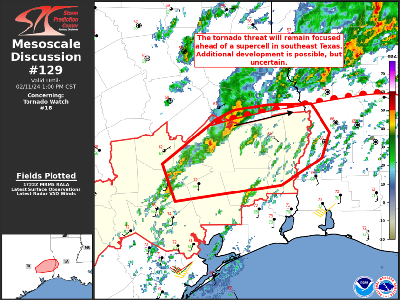
FOR ADDITIONAL INFORMATION SEE MESOSCALE DISCUSSION 129
..MOORE..02/11/24
ATTN...WFO...HGX...LCH...
&&
STATUS REPORT FOR WT 18
SEVERE WEATHER THREAT CONTINUES FOR THE FOLLOWING AREAS
TXC199-201-241-291-351-373-457-111940-
TX
. TEXAS COUNTIES INCLUDED ARE
HARDIN HARRIS JASPER
LIBERTY NEWTON POLK
TYLER
$$
THE WATCH STATUS MESSAGE IS FOR GUIDANCE PURPOSES ONLY. PLEASE
REFER TO WATCH COUNTY NOTIFICATION STATEMENTS FOR OFFICIAL
INFORMATION ON COUNTIES...INDEPENDENT CITIES AND MARINE ZONES
CLEARED FROM SEVERE THUNDERSTORM AND TORNADO WATCHES.
$$
STATUS REPORT #3 ON WW 18
VALID 111730Z - 111840Z
SEVERE WEATHER THREAT CONTINUES RIGHT OF A LINE FROM 40 NNE VCT
TO 10 ENE LFK.
FOR ADDITIONAL INFORMATION SEE MESOSCALE DISCUSSION 129
..MOORE..02/11/24
ATTN...WFO...HGX...LCH...
&&
STATUS REPORT FOR WT 18
SEVERE WEATHER THREAT CONTINUES FOR THE FOLLOWING AREAS
TXC199-201-241-291-339-351-373-407-457-111840-
TX
. TEXAS COUNTIES INCLUDED ARE
HARDIN HARRIS JASPER
LIBERTY MONTGOMERY NEWTON
POLK SAN JACINTO TYLER
$$
THE WATCH STATUS MESSAGE IS FOR GUIDANCE PURPOSES ONLY. PLEASE
REFER TO WATCH COUNTY NOTIFICATION STATEMENTS FOR OFFICIAL
INFORMATION ON COUNTIES...INDEPENDENT CITIES AND MARINE ZONES
CLEARED FROM SEVERE THUNDERSTORM AND TORNADO WATCHES.
$$
STATUS REPORT #2 ON WW 18
VALID 111625Z - 111740Z
SEVERE WEATHER THREAT CONTINUES RIGHT OF A LINE FROM 45 N VCT TO
20 W LFK.
..MOORE..02/11/24
ATTN...WFO...HGX...LCH...
&&
STATUS REPORT FOR WT 18
SEVERE WEATHER THREAT CONTINUES FOR THE FOLLOWING AREAS
TXC015-089-199-201-241-291-339-351-373-407-457-471-473-111740-
TX
. TEXAS COUNTIES INCLUDED ARE
AUSTIN COLORADO HARDIN
HARRIS JASPER LIBERTY
MONTGOMERY NEWTON POLK
SAN JACINTO TYLER WALKER
WALLER
$$
THE WATCH STATUS MESSAGE IS FOR GUIDANCE PURPOSES ONLY. PLEASE
REFER TO WATCH COUNTY NOTIFICATION STATEMENTS FOR OFFICIAL
INFORMATION ON COUNTIES...INDEPENDENT CITIES AND MARINE ZONES
CLEARED FROM SEVERE THUNDERSTORM AND TORNADO WATCHES.
$$
STATUS REPORT #1 ON WW 18
VALID 111540Z - 111640Z
THE SEVERE WEATHER THREAT CONTINUES ACROSS THE ENTIRE WATCH AREA.
..GLEASON..02/11/24
ATTN...WFO...HGX...LCH...
&&
STATUS REPORT FOR WT 18
SEVERE WEATHER THREAT CONTINUES FOR THE FOLLOWING AREAS
TXC015-089-185-199-201-241-291-339-351-373-407-457-471-473-477-
111640-
TX
. TEXAS COUNTIES INCLUDED ARE
AUSTIN COLORADO GRIMES
HARDIN HARRIS JASPER
LIBERTY MONTGOMERY NEWTON
POLK SAN JACINTO TYLER
WALKER WALLER WASHINGTON
$$
THE WATCH STATUS MESSAGE IS FOR GUIDANCE PURPOSES ONLY. PLEASE
REFER TO WATCH COUNTY NOTIFICATION STATEMENTS FOR OFFICIAL
INFORMATION ON COUNTIES...INDEPENDENT CITIES AND MARINE ZONES
CLEARED FROM SEVERE THUNDERSTORM AND TORNADO WATCHES.
$$
Note:
Click for Complete Product Text.
Tornadoes
Probability of 2 or more tornadoes
|
Mod (40%)
|
Probability of 1 or more strong (EF2-EF5) tornadoes
|
Low (20%)
|
Wind
Probability of 10 or more severe wind events
|
Mod (40%)
|
Probability of 1 or more wind events > 65 knots
|
Low (20%)
|
Hail
Probability of 10 or more severe hail events
|
Mod (40%)
|
Probability of 1 or more hailstones > 2 inches
|
Mod (40%)
|
Combined Severe Hail/Wind
Probability of 6 or more combined severe hail/wind events
|
High (70%)
|
For each watch, probabilities for particular events inside the watch
(listed above in each table) are determined by the issuing forecaster.
The "Low" category contains probability values ranging from less than 2%
to 20% (EF2-EF5 tornadoes), less than 5% to 20% (all other probabilities),
"Moderate" from 30% to 60%, and "High" from 70% to greater than 95%.
High values are bolded and lighter in color to provide awareness of
an increased threat for a particular event.


 @NWSSPC