Note:
The expiration time in the watch graphic is amended if the watch is
replaced, cancelled or extended.
Note:
Note:
The expiration time in the watch graphic is amended if the watch is
replaced, cancelled or extended.
Note: Click for
Watch Status Reports.
SEL6
URGENT - IMMEDIATE BROADCAST REQUESTED
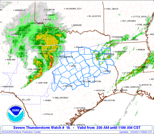
Severe Thunderstorm Watch Number 16
NWS Storm Prediction Center Norman OK
230 AM CST Sun Feb 11 2024
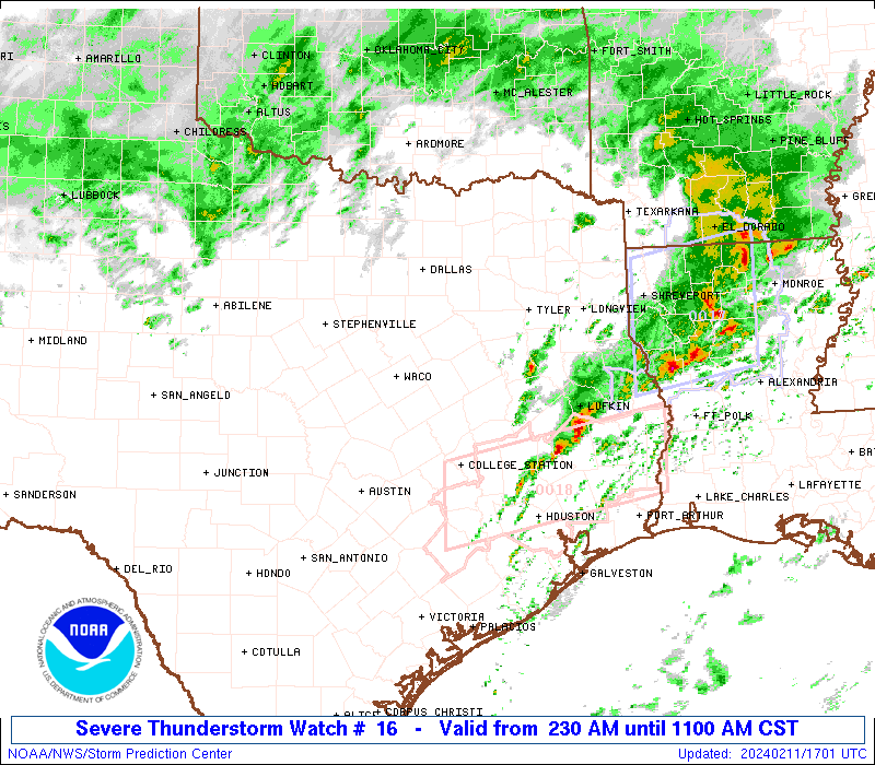
The NWS Storm Prediction Center has issued a
* Severe Thunderstorm Watch for portions of
Central and East Texas
* Effective this Sunday morning from 230 AM until 1100 AM CST.
* Primary threats include...
Scattered large hail events to 1.5 inches in diameter possible
Isolated damaging wind gusts to 65 mph possible
A tornado or two possible
SUMMARY...A corridor of strong to severe thunderstorms will continue
to progress east-northeastward toward and to the east of the
I-35/I-45 corridors through the early morning hours, with the most
intense storms remaining capable of large hail and localized strong
wind gusts. Additional severe development may occur on an initially
(pre-dawn) more isolated basis across east/east-central Texas.
The severe thunderstorm watch area is approximately along and 70
statute miles north and south of a line from 55 miles west of Temple
TX to 30 miles southeast of Longview TX. For a complete depiction of
the watch see the associated watch outline update (WOUS64 KWNS
WOU6).
PRECAUTIONARY/PREPAREDNESS ACTIONS...
REMEMBER...A Severe Thunderstorm Watch means conditions are
favorable for severe thunderstorms in and close to the watch area.
Persons in these areas should be on the lookout for threatening
weather conditions and listen for later statements and possible
warnings. Severe thunderstorms can and occasionally do produce
tornadoes.
&&
OTHER WATCH INFORMATION...CONTINUE...WW 15...
AVIATION...A few severe thunderstorms with hail surface and aloft to
1.5 inches. Extreme turbulence and surface wind gusts to 55 knots. A
few cumulonimbi with maximum tops to 450. Mean storm motion vector
25035.
...Guyer
   SEL6

   URGENT - IMMEDIATE BROADCAST REQUESTED
   Severe Thunderstorm Watch Number 16
   NWS Storm Prediction Center Norman OK
   230 AM CST Sun Feb 11 2024

   The NWS Storm Prediction Center has issued a

   * Severe Thunderstorm Watch for portions of
     Central and East Texas

   * Effective this Sunday morning from 230 AM until 1100 AM CST.

   * Primary threats include...
     Scattered large hail events to 1.5 inches in diameter possible
     Isolated damaging wind gusts to 65 mph possible
     A tornado or two possible

   SUMMARY...A corridor of strong to severe thunderstorms will continue
   to progress east-northeastward toward and to the east of the
   I-35/I-45 corridors through the early morning hours, with the most
   intense storms remaining capable of large hail and localized strong
   wind gusts. Additional severe development may occur on an initially
   (pre-dawn) more isolated basis across east/east-central Texas.

   The severe thunderstorm watch area is approximately along and 70
   statute miles north and south of a line from 55 miles west of Temple
   TX to 30 miles southeast of Longview TX. For a complete depiction of
   the watch see the associated watch outline update (WOUS64 KWNS
   WOU6).

   PRECAUTIONARY/PREPAREDNESS ACTIONS...

   REMEMBER...A Severe Thunderstorm Watch means conditions are
   favorable for severe thunderstorms in and close to the watch area.
   Persons in these areas should be on the lookout for threatening
   weather conditions and listen for later statements and possible
   warnings. Severe thunderstorms can and occasionally do produce
   tornadoes.

   &&

   OTHER WATCH INFORMATION...CONTINUE...WW 15...

   AVIATION...A few severe thunderstorms with hail surface and aloft to
   1.5 inches. Extreme turbulence and surface wind gusts to 55 knots. A
   few cumulonimbi with maximum tops to 450. Mean storm motion vector
   25035.

   ...Guyer
 Note:
The Aviation Watch (SAW) product is an approximation to the watch area.
The actual watch is depicted by the shaded areas.
Note:
The Aviation Watch (SAW) product is an approximation to the watch area.
The actual watch is depicted by the shaded areas.
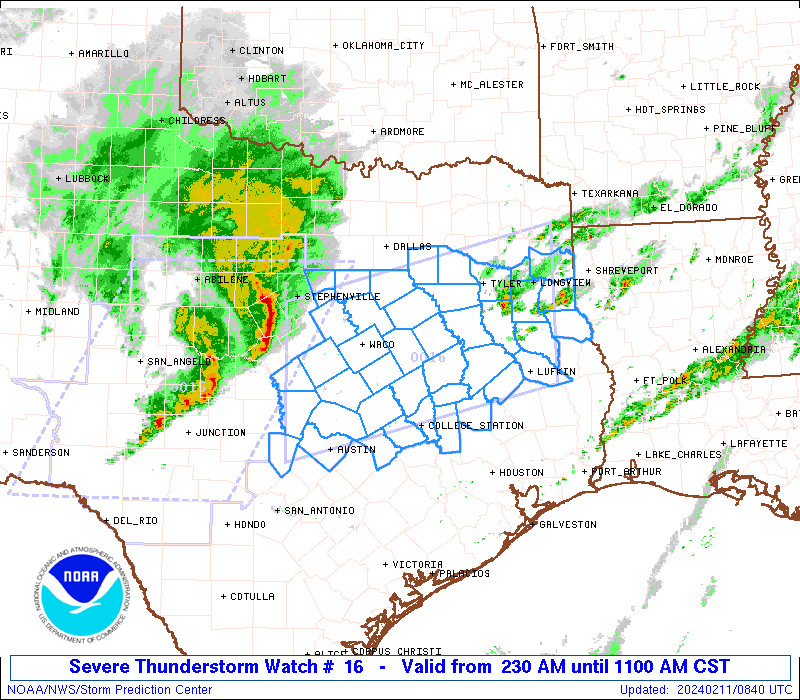
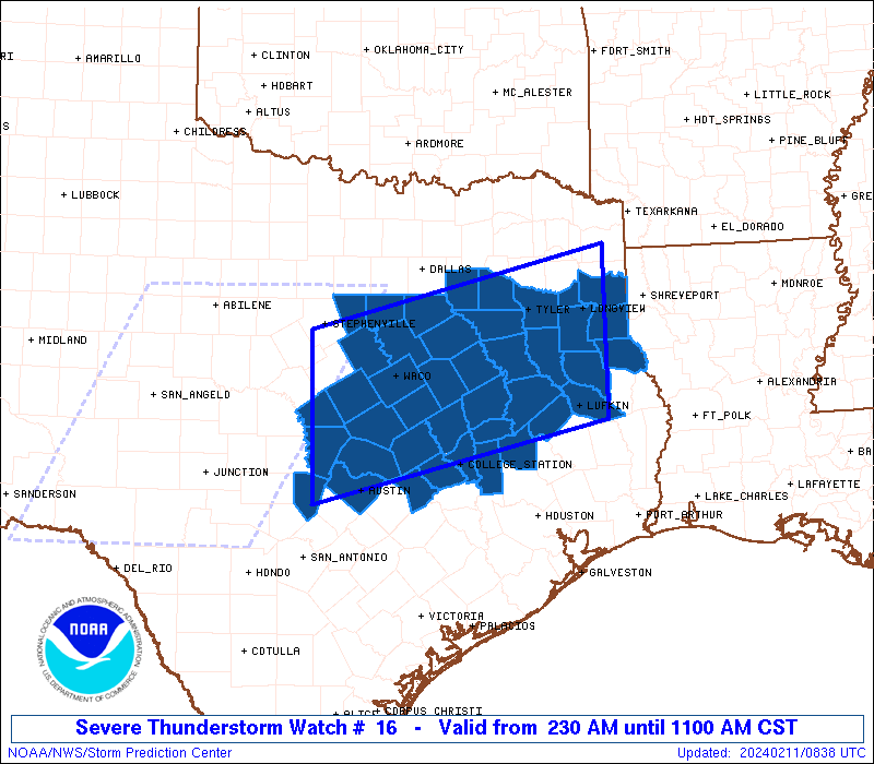
   SAW6
   WW 16 SEVERE TSTM TX 110830Z - 111700Z
   AXIS..70 STATUTE MILES NORTH AND SOUTH OF LINE..
   55W TPL/TEMPLE TX/ - 30SE GGG/LONGVIEW TX/
   ..AVIATION COORDS.. 60NM N/S /63NW CWK - 29SE GGG/
   HAIL SURFACE AND ALOFT..1.5 INCHES. WIND GUSTS..55 KNOTS.
   MAX TOPS TO 450. MEAN STORM MOTION VECTOR 25035.

   LAT...LON 32169835 33099436 31069436 30139835

   THIS IS AN APPROXIMATION TO THE WATCH AREA.  FOR A
   COMPLETE DEPICTION OF THE WATCH SEE WOUS64 KWNS
   FOR WOU6.
Watch 16 Status Report Messages:
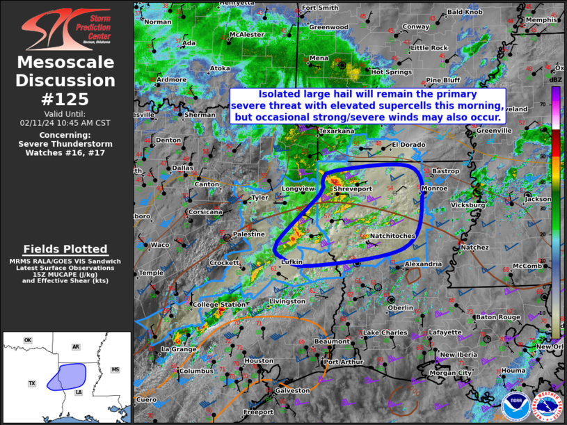
STATUS REPORT #7 ON WW 16

VALID 111625Z - 111740Z

SEVERE WEATHER THREAT CONTINUES RIGHT OF A LINE FROM 25 WSW UTS
TO 25 NNE LFK TO 25 N SHV.

FOR ADDITIONAL INFORMATION SEE MESOSCALE DISCUSSION 125

..MOORE..02/11/24

ATTN...WFO...FWD...SHV...EWX...HGX...

&&

STATUS REPORT FOR WS 16

SEVERE WEATHER THREAT CONTINUES FOR THE FOLLOWING AREAS

TXC005-419-111740-

TX
.    TEXAS COUNTIES INCLUDED ARE

ANGELINA	     SHELBY
$$


THE WATCH STATUS MESSAGE IS FOR GUIDANCE PURPOSES ONLY.  PLEASE
REFER TO WATCH COUNTY NOTIFICATION STATEMENTS FOR OFFICIAL
INFORMATION ON COUNTIES...INDEPENDENT CITIES AND MARINE ZONES
CLEARED FROM SEVERE THUNDERSTORM AND TORNADO WATCHES.
$$

STATUS REPORT #6 ON WW 16

VALID 111540Z - 111640Z

SEVERE WEATHER THREAT CONTINUES RIGHT OF A LINE FROM 10 W UTS TO
20 NW LFK TO 35 SW SHV.

FOR ADDITIONAL INFORMATION SEE MESOSCALE DISCUSSION 125

..GLEASON..02/11/24

ATTN...WFO...FWD...SHV...EWX...HGX...

&&

STATUS REPORT FOR WS 16

SEVERE WEATHER THREAT CONTINUES FOR THE FOLLOWING AREAS

TXC005-347-365-419-455-111640-

TX
.    TEXAS COUNTIES INCLUDED ARE

ANGELINA	     NACOGDOCHES	 PANOLA
SHELBY		     TRINITY
$$


THE WATCH STATUS MESSAGE IS FOR GUIDANCE PURPOSES ONLY.  PLEASE
REFER TO WATCH COUNTY NOTIFICATION STATEMENTS FOR OFFICIAL
INFORMATION ON COUNTIES...INDEPENDENT CITIES AND MARINE ZONES
CLEARED FROM SEVERE THUNDERSTORM AND TORNADO WATCHES.
$$

STATUS REPORT #5 ON WW 16

VALID 111450Z - 111540Z

SEVERE WEATHER THREAT CONTINUES RIGHT OF A LINE FROM 35 ESE AUS
TO 20 WNW UTS TO 35 NNW LFK TO 30 SSW GGG TO 25 E GGG.

FOR ADDITIONAL INFORMATION SEE MESOSCALE DISCUSSION 123

..GLEASON..02/11/24

ATTN...WFO...FWD...SHV...EWX...HGX...

&&

STATUS REPORT FOR WS 16

SEVERE WEATHER THREAT CONTINUES FOR THE FOLLOWING AREAS

TXC005-041-051-185-203-225-347-365-401-419-455-471-111540-

TX
.    TEXAS COUNTIES INCLUDED ARE

ANGELINA	     BRAZOS		 BURLESON
GRIMES		     HARRISON		 HOUSTON
NACOGDOCHES	     PANOLA		 RUSK
SHELBY		     TRINITY		 WALKER
$$


THE WATCH STATUS MESSAGE IS FOR GUIDANCE PURPOSES ONLY.  PLEASE
REFER TO WATCH COUNTY NOTIFICATION STATEMENTS FOR OFFICIAL
INFORMATION ON COUNTIES...INDEPENDENT CITIES AND MARINE ZONES
CLEARED FROM SEVERE THUNDERSTORM AND TORNADO WATCHES.
$$

STATUS REPORT #4 ON WW 16

VALID 111325Z - 111440Z

SEVERE WEATHER THREAT CONTINUES RIGHT OF A LINE FROM 25 ENE AUS
TO 35 N CLL TO 45 SSE CRS TO 35 SE CRS TO 10 SSE TYR TO 35 N TYR.

..KERR..02/11/24

ATTN...WFO...FWD...SHV...EWX...HGX...

&&

STATUS REPORT FOR WS 16

SEVERE WEATHER THREAT CONTINUES FOR THE FOLLOWING AREAS

TXC001-005-041-051-073-183-185-203-225-289-313-347-365-395-401-
419-423-455-471-111440-

TX
.    TEXAS COUNTIES INCLUDED ARE

ANDERSON	     ANGELINA		 BRAZOS
BURLESON	     CHEROKEE		 GREGG
GRIMES		     HARRISON		 HOUSTON
LEON		     MADISON		 NACOGDOCHES
PANOLA		     ROBERTSON		 RUSK
SHELBY		     SMITH		 TRINITY
WALKER
$$


THE WATCH STATUS MESSAGE IS FOR GUIDANCE PURPOSES ONLY.  PLEASE
REFER TO WATCH COUNTY NOTIFICATION STATEMENTS FOR OFFICIAL
INFORMATION ON COUNTIES...INDEPENDENT CITIES AND MARINE ZONES
CLEARED FROM SEVERE THUNDERSTORM AND TORNADO WATCHES.
$$

STATUS REPORT #3 ON WW 16

VALID 111245Z - 111340Z

SEVERE WEATHER THREAT CONTINUES RIGHT OF A LINE FROM 5 NNE AUS TO
35 ESE ACT TO 25 E CRS TO 45 ESE DAL.

..KERR..02/11/24

ATTN...WFO...FWD...SHV...EWX...HGX...

&&

STATUS REPORT FOR WS 16

SEVERE WEATHER THREAT CONTINUES FOR THE FOLLOWING AREAS

TXC001-005-041-051-073-161-183-185-203-213-225-287-289-293-313-
331-347-365-395-401-419-423-455-467-471-111340-

TX
.    TEXAS COUNTIES INCLUDED ARE

ANDERSON	     ANGELINA		 BRAZOS
BURLESON	     CHEROKEE		 FREESTONE
GREGG		     GRIMES		 HARRISON
HENDERSON	     HOUSTON		 LEE
LEON		     LIMESTONE		 MADISON
MILAM		     NACOGDOCHES	 PANOLA
ROBERTSON	     RUSK		 SHELBY
SMITH		     TRINITY		 VAN ZANDT
WALKER
$$


THE WATCH STATUS MESSAGE IS FOR GUIDANCE PURPOSES ONLY.  PLEASE
REFER TO WATCH COUNTY NOTIFICATION STATEMENTS FOR OFFICIAL
INFORMATION ON COUNTIES...INDEPENDENT CITIES AND MARINE ZONES
CLEARED FROM SEVERE THUNDERSTORM AND TORNADO WATCHES.
$$

STATUS REPORT #2 ON WW 16

VALID 111130Z - 111240Z

SEVERE WEATHER THREAT CONTINUES RIGHT OF A LINE FROM 40 W AUS TO
15 WSW ACT TO 15 W CRS TO 20 SSE DAL.

..KERR..02/11/24

ATTN...WFO...FWD...SHV...EWX...HGX...

&&

STATUS REPORT FOR WS 16

SEVERE WEATHER THREAT CONTINUES FOR THE FOLLOWING AREAS

TXC001-005-027-031-041-051-073-145-161-183-185-203-213-225-257-
287-289-293-309-313-331-347-349-365-395-401-419-423-453-455-467-
471-491-111240-

TX
.    TEXAS COUNTIES INCLUDED ARE

ANDERSON	     ANGELINA		 BELL
BLANCO		     BRAZOS		 BURLESON
CHEROKEE	     FALLS		 FREESTONE
GREGG		     GRIMES		 HARRISON
HENDERSON	     HOUSTON		 KAUFMAN
LEE		     LEON		 LIMESTONE
MCLENNAN	     MADISON		 MILAM
NACOGDOCHES	     NAVARRO		 PANOLA
ROBERTSON	     RUSK		 SHELBY
SMITH		     TRAVIS		 TRINITY
VAN ZANDT	     WALKER		 WILLIAMSON
$$


THE WATCH STATUS MESSAGE IS FOR GUIDANCE PURPOSES ONLY.  PLEASE
REFER TO WATCH COUNTY NOTIFICATION STATEMENTS FOR OFFICIAL
INFORMATION ON COUNTIES...INDEPENDENT CITIES AND MARINE ZONES
CLEARED FROM SEVERE THUNDERSTORM AND TORNADO WATCHES.
$$

STATUS REPORT #1 ON WW 16

VALID 111045Z - 111140Z

SEVERE WEATHER THREAT CONTINUES RIGHT OF A LINE FROM 55 W TPL TO
15 NNW ACT TO 25 S FTW.

..KERR..02/11/24

ATTN...WFO...FWD...SHV...EWX...HGX...

&&

STATUS REPORT FOR WS 16

SEVERE WEATHER THREAT CONTINUES FOR THE FOLLOWING AREAS

TXC001-005-027-031-041-051-053-073-099-139-145-161-183-185-203-
213-217-225-251-257-281-287-289-293-309-313-331-347-349-365-395-
401-419-423-453-455-467-471-491-111140-

TX
.    TEXAS COUNTIES INCLUDED ARE

ANDERSON	     ANGELINA		 BELL
BLANCO		     BRAZOS		 BURLESON
BURNET		     CHEROKEE		 CORYELL
ELLIS		     FALLS		 FREESTONE
GREGG		     GRIMES		 HARRISON
HENDERSON	     HILL		 HOUSTON
JOHNSON 	     KAUFMAN		 LAMPASAS
LEE		     LEON		 LIMESTONE
MCLENNAN	     MADISON		 MILAM
NACOGDOCHES	     NAVARRO		 PANOLA
ROBERTSON	     RUSK		 SHELBY
SMITH		     TRAVIS		 TRINITY
VAN ZANDT	     WALKER		 WILLIAMSON
$$


THE WATCH STATUS MESSAGE IS FOR GUIDANCE PURPOSES ONLY.  PLEASE
REFER TO WATCH COUNTY NOTIFICATION STATEMENTS FOR OFFICIAL
INFORMATION ON COUNTIES...INDEPENDENT CITIES AND MARINE ZONES
CLEARED FROM SEVERE THUNDERSTORM AND TORNADO WATCHES.
$$
Note:
Click for Complete Product Text.
Tornadoes
Probability of 2 or more tornadoes
|
Low (20%)
|
Probability of 1 or more strong (EF2-EF5) tornadoes
|
Low (<2%)
|
Wind
Probability of 10 or more severe wind events
|
Low (20%)
|
Probability of 1 or more wind events > 65 knots
|
Low (<5%)
|
Hail
Probability of 10 or more severe hail events
|
Mod (40%)
|
Probability of 1 or more hailstones > 2 inches
|
Low (20%)
|
Combined Severe Hail/Wind
Probability of 6 or more combined severe hail/wind events
|
High (70%)
|
For each watch, probabilities for particular events inside the watch
(listed above in each table) are determined by the issuing forecaster.
The "Low" category contains probability values ranging from less than 2%
to 20% (EF2-EF5 tornadoes), less than 5% to 20% (all other probabilities),
"Moderate" from 30% to 60%, and "High" from 70% to greater than 95%.
High values are bolded and lighter in color to provide awareness of
an increased threat for a particular event.


 @NWSSPC