Note:
The expiration time in the watch graphic is amended if the watch is
replaced, cancelled or extended.
Note:
Note:
The expiration time in the watch graphic is amended if the watch is
replaced, cancelled or extended.
Note: Click for
Watch Status Reports.
SEL7
URGENT - IMMEDIATE BROADCAST REQUESTED
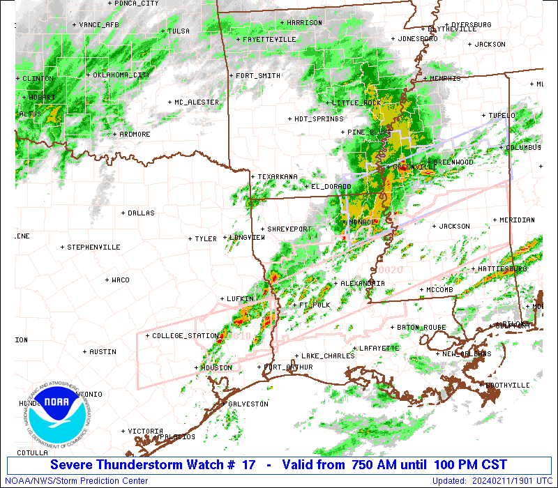
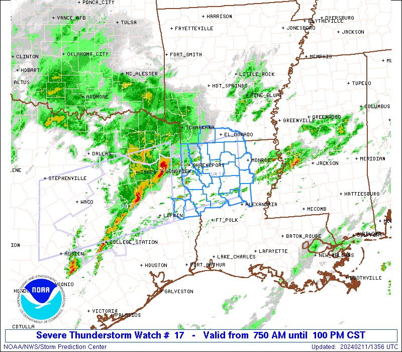
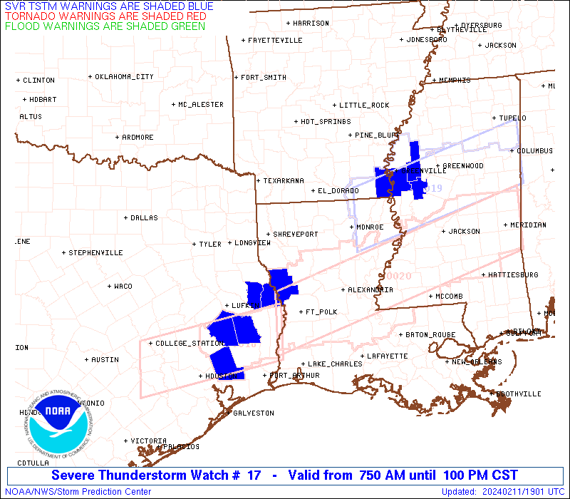
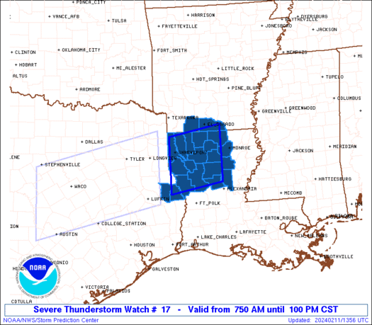
Severe Thunderstorm Watch Number 17
NWS Storm Prediction Center Norman OK
750 AM CST Sun Feb 11 2024
The NWS Storm Prediction Center has issued a
* Severe Thunderstorm Watch for portions of
Far Southern Arkansas
Northern Louisiana
Far East Texas
* Effective this Sunday morning and afternoon from 750 AM until
100 PM CST.
* Primary threats include...
Scattered large hail and isolated very large hail events to 2
inches in diameter possible
Isolated damaging wind gusts to 60 mph possible
SUMMARY...Strong to severe thunderstorms may continue
east-northeastward this morning into western/northern Louisiana and
far southern Arkansas, with the strongest storms capable of large
hail and possibly strong wind gusts.
The severe thunderstorm watch area is approximately along and 55
statute miles north and south of a line from 25 miles south
southwest of Shreveport LA to 65 miles northeast of Natchitoches LA.
For a complete depiction of the watch see the associated watch
outline update (WOUS64 KWNS WOU7).
PRECAUTIONARY/PREPAREDNESS ACTIONS...
REMEMBER...A Severe Thunderstorm Watch means conditions are
favorable for severe thunderstorms in and close to the watch area.
Persons in these areas should be on the lookout for threatening
weather conditions and listen for later statements and possible
warnings. Severe thunderstorms can and occasionally do produce
tornadoes.
&&
OTHER WATCH INFORMATION...CONTINUE...WW 16...
AVIATION...A few severe thunderstorms with hail surface and aloft to
2 inches. Extreme turbulence and surface wind gusts to 50 knots. A
few cumulonimbi with maximum tops to 450. Mean storm motion vector
25035.
...Guyer

   SEL7

   URGENT - IMMEDIATE BROADCAST REQUESTED
   Severe Thunderstorm Watch Number 17
   NWS Storm Prediction Center Norman OK
   750 AM CST Sun Feb 11 2024

   The NWS Storm Prediction Center has issued a

   * Severe Thunderstorm Watch for portions of
     Far Southern Arkansas
     Northern Louisiana
     Far East Texas

   * Effective this Sunday morning and afternoon from 750 AM until
     100 PM CST.

   * Primary threats include...
     Scattered large hail and isolated very large hail events to 2
       inches in diameter possible
     Isolated damaging wind gusts to 60 mph possible

   SUMMARY...Strong to severe thunderstorms may continue
   east-northeastward this morning into western/northern Louisiana and
   far southern Arkansas, with the strongest storms capable of large
   hail and possibly strong wind gusts.

   The severe thunderstorm watch area is approximately along and 55
   statute miles north and south of a line from 25 miles south
   southwest of Shreveport LA to 65 miles northeast of Natchitoches LA.
   For a complete depiction of the watch see the associated watch
   outline update (WOUS64 KWNS WOU7).

   PRECAUTIONARY/PREPAREDNESS ACTIONS...

   REMEMBER...A Severe Thunderstorm Watch means conditions are
   favorable for severe thunderstorms in and close to the watch area.
   Persons in these areas should be on the lookout for threatening
   weather conditions and listen for later statements and possible
   warnings. Severe thunderstorms can and occasionally do produce
   tornadoes.

   &&

   OTHER WATCH INFORMATION...CONTINUE...WW 16...

   AVIATION...A few severe thunderstorms with hail surface and aloft to
   2 inches. Extreme turbulence and surface wind gusts to 50 knots. A
   few cumulonimbi with maximum tops to 450. Mean storm motion vector
   25035.

   ...Guyer
 Note:
The Aviation Watch (SAW) product is an approximation to the watch area.
The actual watch is depicted by the shaded areas.
Note:
The Aviation Watch (SAW) product is an approximation to the watch area.
The actual watch is depicted by the shaded areas.
   SAW7
   WW 17 SEVERE TSTM AR LA TX 111350Z - 111900Z
   AXIS..55 STATUTE MILES NORTH AND SOUTH OF LINE..
   25SSW SHV/SHREVEPORT LA/ - 65NE IER/NATCHITOCHES LA/
   ..AVIATION COORDS.. 50NM N/S /40SSW EIC - 16WSW MLU/
   HAIL SURFACE AND ALOFT..2 INCHES. WIND GUSTS..50 KNOTS.
   MAX TOPS TO 450. MEAN STORM MOTION VECTOR 25035.

   LAT...LON 32919399 33209231 31619231 31329399

   THIS IS AN APPROXIMATION TO THE WATCH AREA.  FOR A
   COMPLETE DEPICTION OF THE WATCH SEE WOUS64 KWNS
   FOR WOU7.
Watch 17 Status Report Messages:
STATUS REPORT #5 ON WW 17
VALID 111830Z - 111940Z
SEVERE WEATHER THREAT CONTINUES RIGHT OF A LINE FROM 20 ENE LFK
TO 35 NNE MLU.
..MOORE..02/11/24
ATTN...WFO...SHV...
&&
STATUS REPORT FOR WS 17
SEVERE WEATHER THREAT CONTINUES FOR THE FOLLOWING AREAS
LAC069-073-111940-
LA
. LOUISIANA PARISHES INCLUDED ARE
NATCHITOCHES OUACHITA
$$
TXC403-405-111940-
TX
. TEXAS COUNTIES INCLUDED ARE
SABINE SAN AUGUSTINE
$$
THE WATCH STATUS MESSAGE IS FOR GUIDANCE PURPOSES ONLY. PLEASE
REFER TO WATCH COUNTY NOTIFICATION STATEMENTS FOR OFFICIAL
INFORMATION ON COUNTIES...INDEPENDENT CITIES AND MARINE ZONES
CLEARED FROM SEVERE THUNDERSTORM AND TORNADO WATCHES.
$$
STATUS REPORT #4 ON WW 17
VALID 111730Z - 111840Z
SEVERE WEATHER THREAT CONTINUES RIGHT OF A LINE FROM 20 NE LFK TO
30 ESE SHV TO 15 SW LLQ.
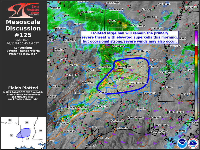
FOR ADDITIONAL INFORMATION SEE MESOSCALE DISCUSSION 125
..MOORE..02/11/24
ATTN...WFO...SHV...
&&
STATUS REPORT FOR WS 17
SEVERE WEATHER THREAT CONTINUES FOR THE FOLLOWING AREAS
LAC013-021-031-043-049-059-061-069-073-081-085-111-127-111840-
LA
. LOUISIANA PARISHES INCLUDED ARE
BIENVILLE CALDWELL DE SOTO
GRANT JACKSON LA SALLE
LINCOLN NATCHITOCHES OUACHITA
RED RIVER SABINE UNION
WINN
$$
TXC403-405-111840-
TX
. TEXAS COUNTIES INCLUDED ARE
SABINE SAN AUGUSTINE
$$
THE WATCH STATUS MESSAGE IS FOR GUIDANCE PURPOSES ONLY. PLEASE
REFER TO WATCH COUNTY NOTIFICATION STATEMENTS FOR OFFICIAL
INFORMATION ON COUNTIES...INDEPENDENT CITIES AND MARINE ZONES
CLEARED FROM SEVERE THUNDERSTORM AND TORNADO WATCHES.
$$
STATUS REPORT #3 ON WW 17
VALID 111625Z - 111740Z
SEVERE WEATHER THREAT CONTINUES RIGHT OF A LINE FROM 40 NNE LFK
TO 35 ENE SHV TO 25 NNE ELD.
FOR ADDITIONAL INFORMATION SEE MESOSCALE DISCUSSION 125
..MOORE..02/11/24
ATTN...WFO...SHV...
&&
STATUS REPORT FOR WS 17
SEVERE WEATHER THREAT CONTINUES FOR THE FOLLOWING AREAS
ARC139-111740-
AR
. ARKANSAS COUNTIES INCLUDED ARE
UNION
$$
LAC013-021-027-031-043-049-059-061-069-073-081-085-111-127-
111740-
LA
. LOUISIANA PARISHES INCLUDED ARE
BIENVILLE CALDWELL CLAIBORNE
DE SOTO GRANT JACKSON
LA SALLE LINCOLN NATCHITOCHES
OUACHITA RED RIVER SABINE
UNION WINN
$$
TXC403-405-111740-
TX
. TEXAS COUNTIES INCLUDED ARE
SABINE SAN AUGUSTINE
$$
THE WATCH STATUS MESSAGE IS FOR GUIDANCE PURPOSES ONLY. PLEASE
REFER TO WATCH COUNTY NOTIFICATION STATEMENTS FOR OFFICIAL
INFORMATION ON COUNTIES...INDEPENDENT CITIES AND MARINE ZONES
CLEARED FROM SEVERE THUNDERSTORM AND TORNADO WATCHES.
$$
STATUS REPORT #2 ON WW 17
VALID 111540Z - 111640Z
THE SEVERE WEATHER THREAT CONTINUES ACROSS THE ENTIRE WATCH AREA.
FOR ADDITIONAL INFORMATION SEE MESOSCALE DISCUSSION 125
..GLEASON..02/11/24
ATTN...WFO...SHV...
&&
STATUS REPORT FOR WS 17
SEVERE WEATHER THREAT CONTINUES FOR THE FOLLOWING AREAS
ARC027-139-111640-
AR
. ARKANSAS COUNTIES INCLUDED ARE
COLUMBIA UNION
$$
LAC013-015-017-021-027-031-043-049-059-061-069-073-081-085-111-
119-127-111640-
LA
. LOUISIANA PARISHES INCLUDED ARE
BIENVILLE BOSSIER CADDO
CALDWELL CLAIBORNE DE SOTO
GRANT JACKSON LA SALLE
LINCOLN NATCHITOCHES OUACHITA
RED RIVER SABINE UNION
WEBSTER WINN
$$
TXC403-405-111640-
TX
. TEXAS COUNTIES INCLUDED ARE
SABINE SAN AUGUSTINE
$$
THE WATCH STATUS MESSAGE IS FOR GUIDANCE PURPOSES ONLY. PLEASE
REFER TO WATCH COUNTY NOTIFICATION STATEMENTS FOR OFFICIAL
INFORMATION ON COUNTIES...INDEPENDENT CITIES AND MARINE ZONES
CLEARED FROM SEVERE THUNDERSTORM AND TORNADO WATCHES.
$$
STATUS REPORT #1 ON WW 17
VALID 111450Z - 111540Z
THE SEVERE WEATHER THREAT CONTINUES ACROSS THE ENTIRE WATCH AREA.
..GLEASON..02/11/24
ATTN...WFO...SHV...
&&
STATUS REPORT FOR WS 17
SEVERE WEATHER THREAT CONTINUES FOR THE FOLLOWING AREAS
ARC027-139-111540-
AR
. ARKANSAS COUNTIES INCLUDED ARE
COLUMBIA UNION
$$
LAC013-015-017-021-027-031-043-049-059-061-069-073-081-085-111-
119-127-111540-
LA
. LOUISIANA PARISHES INCLUDED ARE
BIENVILLE BOSSIER CADDO
CALDWELL CLAIBORNE DE SOTO
GRANT JACKSON LA SALLE
LINCOLN NATCHITOCHES OUACHITA
RED RIVER SABINE UNION
WEBSTER WINN
$$
TXC403-405-111540-
TX
. TEXAS COUNTIES INCLUDED ARE
SABINE SAN AUGUSTINE
$$
THE WATCH STATUS MESSAGE IS FOR GUIDANCE PURPOSES ONLY. PLEASE
REFER TO WATCH COUNTY NOTIFICATION STATEMENTS FOR OFFICIAL
INFORMATION ON COUNTIES...INDEPENDENT CITIES AND MARINE ZONES
CLEARED FROM SEVERE THUNDERSTORM AND TORNADO WATCHES.
$$
Note:
Click for Complete Product Text.
Tornadoes
Probability of 2 or more tornadoes
|
Low (10%)
|
Probability of 1 or more strong (EF2-EF5) tornadoes
|
Low (5%)
|
Wind
Probability of 10 or more severe wind events
|
Low (20%)
|
Probability of 1 or more wind events > 65 knots
|
Low (10%)
|
Hail
Probability of 10 or more severe hail events
|
Mod (50%)
|
Probability of 1 or more hailstones > 2 inches
|
Mod (30%)
|
Combined Severe Hail/Wind
Probability of 6 or more combined severe hail/wind events
|
High (70%)
|
For each watch, probabilities for particular events inside the watch
(listed above in each table) are determined by the issuing forecaster.
The "Low" category contains probability values ranging from less than 2%
to 20% (EF2-EF5 tornadoes), less than 5% to 20% (all other probabilities),
"Moderate" from 30% to 60%, and "High" from 70% to greater than 95%.
High values are bolded and lighter in color to provide awareness of
an increased threat for a particular event.


 @NWSSPC