|
| Mesoscale Discussion 476 |
|
< Previous MD Next MD >
|
|
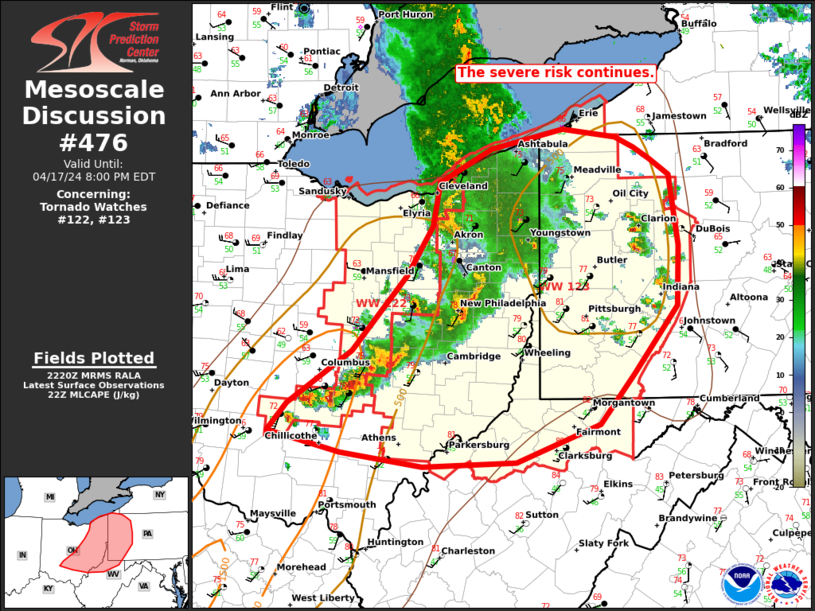
   Mesoscale Discussion 0476
   NWS Storm Prediction Center Norman OK
   0523 PM CDT Wed Apr 17 2024

   Areas affected...portions of eastern OH...western PA...and northern
   WV

   Concerning...Tornado Watch 122...123...

   Valid 172223Z - 180000Z

   The severe weather threat for Tornado Watch 122, 123 continues.

   SUMMARY...The severe risk continues across WW122 and WW123. Damaging
   winds, hail and a couple of tornadoes are possible. A local
   extension has been coordinated on the eastern edge of WW123.

   DISCUSSION...As of 2215 UTC, regional radar analysis showed an
   ongoing cluster of severe storms over east-central OH. A mixed mode
   of line segments and supercellular elements has been noted with
   storms thus far owing to moderate buoyancy and 45-50 kt of effective
   shear. The environment downstream is less moist (low to mid 50s F
   dewpoints), but steep low-level lapse rates and ~500 J/kg of MLCAPE
   will continue to support storm organization into western PA and
   northern WV. With the mixed mode and drier surface conditions,
   damaging wind gusts appear the most likely. Though, long hodographs
   suggest hail and a a couple of tornadoes will also remain possible
   with the more persistent supercells.

   Recent radar and hi-res model trends suggest the southern portions
   of the ongoing cluster are most likely to maintain intensity over
   the next couple of hours. Additional discrete development has also
   been noted farther east ahead of these storms. Given the potential
   for the severe risk to extend into western PA this evening, a local
   extension of WW123 eastward has being coordinated.

   ..Lyons/Guyer.. 04/17/2024

   ...Please see www.spc.noaa.gov for graphic product...

   ATTN...WFO...CTP...PBZ...RLX...CLE...ILN...

   LAT...LON   39507983 39168077 39128182 39248275 39428356 39668334
               40128262 40778202 41218172 41588164 41878106 42048024
               41987964 41887943 41787925 41657903 41047893 40517896
               39937944 39507983
|
|
Top/All Mesoscale Discussions/Forecast Products/Home
|
|


 @NWSSPC