 Note:
The expiration time in the watch graphic is amended if the watch is
replaced, cancelled or extended.
Note:
Note:
The expiration time in the watch graphic is amended if the watch is
replaced, cancelled or extended.
Note: Click for
Watch Status Reports.
SEL3
URGENT - IMMEDIATE BROADCAST REQUESTED
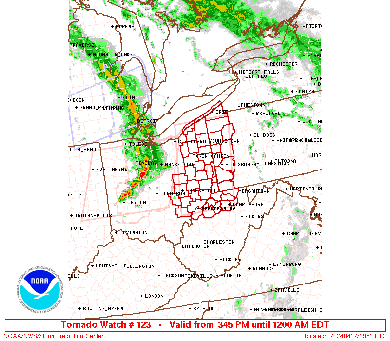
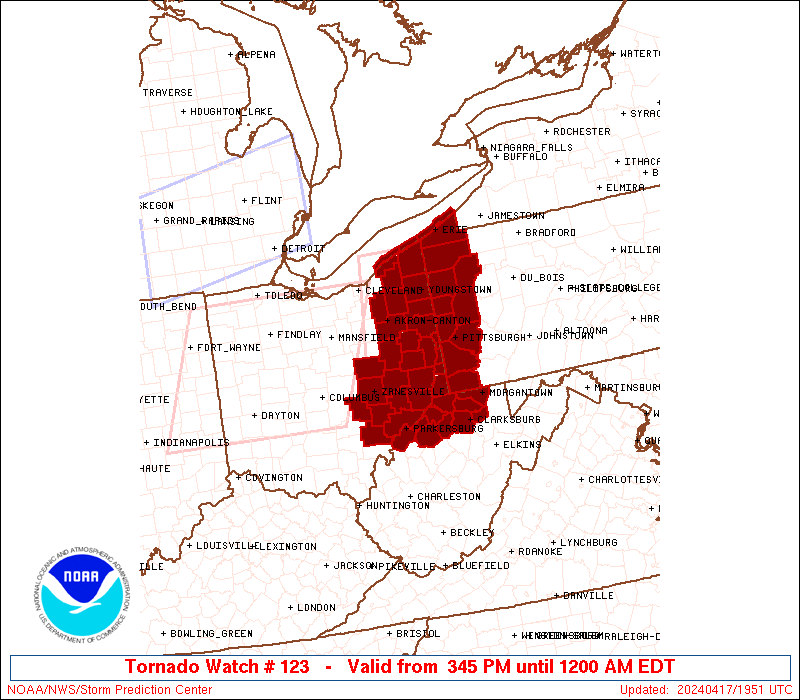
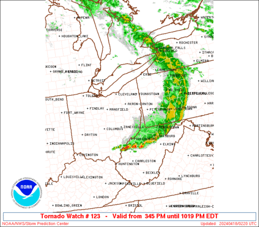
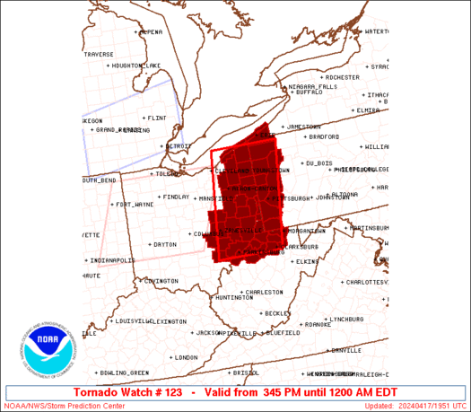
Tornado Watch Number 123
NWS Storm Prediction Center Norman OK
345 PM EDT Wed Apr 17 2024
The NWS Storm Prediction Center has issued a
* Tornado Watch for portions of
Eastern Ohio
Far Western Pennsylvania
Far Northern West Virginia
Lake Erie
* Effective this Wednesday afternoon from 345 PM until Midnight
EDT.
* Primary threats include...
A couple tornadoes possible
Scattered damaging wind gusts to 70 mph possible
Scattered large hail events to 1.5 inches in diameter possible
SUMMARY...Thunderstorms currently ongoing across central Ohio are
expected to continue progressing eastward this afternoon and
evening. The environment ahead of these storms will remain
supportive of supercells capable of tornadoes, hail from 1" to 1.5",
and damaging gusts from 45 to 65 mph.
The tornado watch area is approximately along and 55 statute miles
east and west of a line from 20 miles east southeast of Parkersburg
WV to 45 miles north of Youngstown OH. For a complete depiction of
the watch see the associated watch outline update (WOUS64 KWNS
WOU3).
PRECAUTIONARY/PREPAREDNESS ACTIONS...
REMEMBER...A Tornado Watch means conditions are favorable for
tornadoes and severe thunderstorms in and close to the watch
area. Persons in these areas should be on the lookout for
threatening weather conditions and listen for later statements
and possible warnings.
&&
OTHER WATCH INFORMATION...CONTINUE...WW 121...WW 122...
AVIATION...Tornadoes and a few severe thunderstorms with hail
surface and aloft to 1.5 inches. Extreme turbulence and surface wind
gusts to 60 knots. A few cumulonimbi with maximum tops to 500. Mean
storm motion vector 25035.
...Mosier

   SEL3

   URGENT - IMMEDIATE BROADCAST REQUESTED
   Tornado Watch Number 123
   NWS Storm Prediction Center Norman OK
   345 PM EDT Wed Apr 17 2024

   The NWS Storm Prediction Center has issued a

   * Tornado Watch for portions of
     Eastern Ohio
     Far Western Pennsylvania
     Far Northern West Virginia
     Lake Erie

   * Effective this Wednesday afternoon from 345 PM until Midnight
     EDT.

   * Primary threats include...
     A couple tornadoes possible
     Scattered damaging wind gusts to 70 mph possible
     Scattered large hail events to 1.5 inches in diameter possible

   SUMMARY...Thunderstorms currently ongoing across central Ohio are
   expected to continue progressing eastward this afternoon and
   evening. The environment ahead of these storms will remain
   supportive of supercells capable of tornadoes, hail from 1" to 1.5",
   and damaging gusts from 45 to 65 mph.

   The tornado watch area is approximately along and 55 statute miles
   east and west of a line from 20 miles east southeast of Parkersburg
   WV to 45 miles north of Youngstown OH. For a complete depiction of
   the watch see the associated watch outline update (WOUS64 KWNS
   WOU3).

   PRECAUTIONARY/PREPAREDNESS ACTIONS...

   REMEMBER...A Tornado Watch means conditions are favorable for
   tornadoes and severe thunderstorms in and close to the watch
   area. Persons in these areas should be on the lookout for
   threatening weather conditions and listen for later statements
   and possible warnings.

   &&

   OTHER WATCH INFORMATION...CONTINUE...WW 121...WW 122...

   AVIATION...Tornadoes and a few severe thunderstorms with hail
   surface and aloft to 1.5 inches. Extreme turbulence and surface wind
   gusts to 60 knots. A few cumulonimbi with maximum tops to 500. Mean
   storm motion vector 25035.

   ...Mosier
 Note:
The Aviation Watch (SAW) product is an approximation to the watch area.
The actual watch is depicted by the shaded areas.
Note:
The Aviation Watch (SAW) product is an approximation to the watch area.
The actual watch is depicted by the shaded areas.
   SAW3
   WW 123 TORNADO OH PA WV LE 171945Z - 180400Z
   AXIS..55 STATUTE MILES EAST AND WEST OF LINE..
   20ESE PKB/PARKERSBURG WV/ - 45N YNG/YOUNGSTOWN OH/
   ..AVIATION COORDS.. 50NM E/W /48SSW AIR - 18WSW ERI/
   HAIL SURFACE AND ALOFT..1.5 INCHES. WIND GUSTS..60 KNOTS.
   MAX TOPS TO 500. MEAN STORM MOTION VECTOR 25035.

   LAT...LON 39238211 41908175 41907961 39238006

   THIS IS AN APPROXIMATION TO THE WATCH AREA.  FOR A
   COMPLETE DEPICTION OF THE WATCH SEE WOUS64 KWNS
   FOR WOU3.
Watch 123 Status Report Messages:
STATUS REPORT #2 ON WW 123

VALID 180115Z - 180240Z

SEVERE WEATHER THREAT CONTINUES RIGHT OF A LINE FROM 15 N UNI TO
30 NE PKB TO 25 N MGW TO 20 NNE LBE TO 5 W DUJ TO 20 ENE JHW.

..LYONS..04/18/24

ATTN...WFO...CLE...RLX...PBZ...

&&

STATUS REPORT FOR WT 123

SEVERE WEATHER THREAT CONTINUES FOR THE FOLLOWING AREAS

OHC009-167-180240-

OH
.    OHIO COUNTIES INCLUDED ARE

ATHENS		     WASHINGTON
$$


PAC051-180240-

PA
.    PENNSYLVANIA COUNTIES INCLUDED ARE

FAYETTE
$$


WVC017-033-049-061-073-077-085-091-095-107-180240-

WV
.    WEST VIRGINIA COUNTIES INCLUDED ARE

DODDRIDGE	     HARRISON		 MARION
MONONGALIA	     PLEASANTS		 PRESTON
RITCHIE 	     TAYLOR		 TYLER
WOOD
$$


THE WATCH STATUS MESSAGE IS FOR GUIDANCE PURPOSES ONLY.  PLEASE
REFER TO WATCH COUNTY NOTIFICATION STATEMENTS FOR OFFICIAL
INFORMATION ON COUNTIES...INDEPENDENT CITIES AND MARINE ZONES
CLEARED FROM SEVERE THUNDERSTORM AND TORNADO WATCHES.
$$

STATUS REPORT #1 ON WW 123

VALID 172350Z - 180040Z

SEVERE WEATHER THREAT CONTINUES RIGHT OF A LINE FROM 10 WSW ZZV
TO 25 ENE ZZV TO 20 WNW HLG TO 25 NW PIT TO 25 WNW PIT TO 20 SSE
YNG TO 10 NNE YNG TO 30 W ERI.

..LYONS..04/17/24

ATTN...WFO...CLE...RLX...PBZ...

&&

STATUS REPORT FOR WT 123

SEVERE WEATHER THREAT CONTINUES FOR THE FOLLOWING AREAS

OHC007-009-013-059-067-081-111-115-119-121-127-167-180040-

OH
.    OHIO COUNTIES INCLUDED ARE

ASHTABULA	     ATHENS		 BELMONT
GUERNSEY	     HARRISON		 JEFFERSON
MONROE		     MORGAN		 MUSKINGUM
NOBLE		     PERRY		 WASHINGTON
$$


PAC003-005-007-019-031-039-049-051-053-059-063-065-073-085-121-
125-129-180040-

PA
.    PENNSYLVANIA COUNTIES INCLUDED ARE

ALLEGHENY	     ARMSTRONG		 BEAVER
BUTLER		     CLARION		 CRAWFORD
ERIE		     FAYETTE		 FOREST
GREENE		     INDIANA		 JEFFERSON
LAWRENCE	     MERCER		 VENANGO
WASHINGTON	     WESTMORELAND
$$


WVC009-017-029-033-049-051-061-069-073-077-085-091-095-103-107-
180040-

WV
.    WEST VIRGINIA COUNTIES INCLUDED ARE

BROOKE		     DODDRIDGE		 HANCOCK
HARRISON	     MARION		 MARSHALL
MONONGALIA	     OHIO		 PLEASANTS
PRESTON 	     RITCHIE		 TAYLOR
TYLER		     WETZEL		 WOOD
$$


LEZ148-149-180040-

CW

.    ADJACENT COASTAL WATERS INCLUDED ARE

GENEVA-ON-THE-LAKE TO CONNEAUT OH

CONNEAUT OH TO RIPLEY NY

$$
THE WATCH STATUS MESSAGE IS FOR GUIDANCE PURPOSES ONLY.  PLEASE
REFER TO WATCH COUNTY NOTIFICATION STATEMENTS FOR OFFICIAL
INFORMATION ON COUNTIES...INDEPENDENT CITIES AND MARINE ZONES
CLEARED FROM SEVERE THUNDERSTORM AND TORNADO WATCHES.
$$
Note:
Click for Complete Product Text.
Tornadoes
Probability of 2 or more tornadoes
|
Mod (40%)
|
Probability of 1 or more strong (EF2-EF5) tornadoes
|
Low (20%)
|
Wind
Probability of 10 or more severe wind events
|
Mod (40%)
|
Probability of 1 or more wind events > 65 knots
|
Low (20%)
|
Hail
Probability of 10 or more severe hail events
|
Mod (40%)
|
Probability of 1 or more hailstones > 2 inches
|
Low (20%)
|
Combined Severe Hail/Wind
Probability of 6 or more combined severe hail/wind events
|
High (70%)
|
For each watch, probabilities for particular events inside the watch
(listed above in each table) are determined by the issuing forecaster.
The "Low" category contains probability values ranging from less than 2%
to 20% (EF2-EF5 tornadoes), less than 5% to 20% (all other probabilities),
"Moderate" from 30% to 60%, and "High" from 70% to greater than 95%.
High values are bolded and lighter in color to provide awareness of
an increased threat for a particular event.


 @NWSSPC