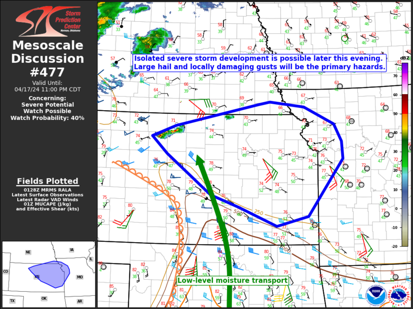
   Mesoscale Discussion 0477
   NWS Storm Prediction Center Norman OK
   0831 PM CDT Wed Apr 17 2024

   Areas affected...Parts of eastern KS...northwest MO...extreme
   southeast NE

   Concerning...Severe potential...Watch possible

   Valid 180131Z - 180400Z

   Probability of Watch Issuance...40 percent

   SUMMARY...Isolated severe storm development is possible later this
   evening. Large hail and localized damaging gusts will be the primary
   hazards.

   DISCUSSION...The 01Z surface analysis depicts a surface low over
   eastern CO, with a confluence zone/dryline extending southeastward
   into south-central KS, then southward across western OK. While
   rather strong diurnal heating occurred across the region this
   afternoon, richer low-level moisture (with surface dewpoints in the
   60s F) currently remains confined to parts of OK/TX. However, an
   increasing low-level jet (as noted in regional VWPs) will aid in
   low-level moisture transport into central/eastern KS later this
   evening. Moderate MLCAPE already noted over OK will spread northward
   into parts of central/eastern KS, though MLCINH will likely remain
   rather stout, rendering surface-based development unlikely. However,
   increasing moisture around 850 mb will support MUCAPE increasing
   above 1000 J/kg later this evening, with decreasing MUCINH as
   moisture deepens above the surface.

   Elevated thunderstorm development has recently been noted west of
   Concordia, and the combined influence of warm advection attendant to
   the increasing low-level jet and a low-amplitude shortwave trough
   traversing the region will support increasing thunderstorm coverage
   later this evening. Moderate elevated buoyancy and sufficient
   effective shear (generally in the 40-50 kt range) will support
   potential for an elevated supercell or two. Large hail is the most
   likely hazard, though the residual well-mixed boundary layer beneath
   returning elevated moisture could also support localized damaging
   gusts. Coverage of the severe threat remains somewhat uncertain, but
   watch issuance is possible later this evening, if a substantial hail
   threat appears imminent.

   ..Dean/Guyer.. 04/18/2024

   ...Please see www.spc.noaa.gov for graphic product...

   ATTN...WFO...SGF...EAX...OAX...TOP...ICT...GID...DDC...

   LAT...LON   38969387 37649490 37429581 37879693 38159774 39079904
               39479948 39739878 40229635 40289601 40179499 39769412
               39369389 38969387
|


 @NWSSPC