Note:
The expiration time in the watch graphic is amended if the watch is
replaced, cancelled or extended.
Note:
Note:
The expiration time in the watch graphic is amended if the watch is
replaced, cancelled or extended.
Note: Click for
Watch Status Reports.
SEL2
URGENT - IMMEDIATE BROADCAST REQUESTED
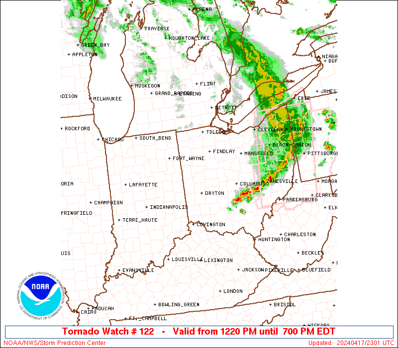
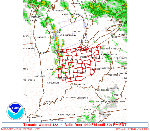
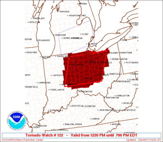
Tornado Watch Number 122
NWS Storm Prediction Center Norman OK
1220 PM EDT Wed Apr 17 2024
The NWS Storm Prediction Center has issued a
* Tornado Watch for portions of
Eastern Indiana
Western and Central Ohio
Lake Erie
* Effective this Wednesday afternoon and evening from 1220 PM
until 700 PM EDT.
* Primary threats include...
A couple tornadoes possible
Scattered damaging wind gusts to 70 mph possible
Scattered large hail events to 1.5 inches in diameter possible
SUMMARY...Thunderstorm coverage is expected to increase over the
next several hours. Environmental conditions support the potential
for a few supercells capable of tornadoes, large hail 1" to 1.5" in
diameter, and damaging gusts from 50 to 60 mph.
The tornado watch area is approximately along and 90 statute miles
east and west of a line from 25 miles south of Dayton OH to 40 miles
north northeast of Findlay OH. For a complete depiction of the watch
see the associated watch outline update (WOUS64 KWNS WOU2).
PRECAUTIONARY/PREPAREDNESS ACTIONS...
REMEMBER...A Tornado Watch means conditions are favorable for
tornadoes and severe thunderstorms in and close to the watch
area. Persons in these areas should be on the lookout for
threatening weather conditions and listen for later statements
and possible warnings.
&&
OTHER WATCH INFORMATION...CONTINUE...WW 121...
AVIATION...Tornadoes and a few severe thunderstorms with hail
surface and aloft to 1.5 inches. Extreme turbulence and surface wind
gusts to 60 knots. A few cumulonimbi with maximum tops to 500. Mean
storm motion vector 24030.
...Mosier
   SEL2

   URGENT - IMMEDIATE BROADCAST REQUESTED
   Tornado Watch Number 122
   NWS Storm Prediction Center Norman OK
   1220 PM EDT Wed Apr 17 2024

   The NWS Storm Prediction Center has issued a

   * Tornado Watch for portions of
     Eastern Indiana
     Western and Central Ohio
     Lake Erie

   * Effective this Wednesday afternoon and evening from 1220 PM
     until 700 PM EDT.

   * Primary threats include...
     A couple tornadoes possible
     Scattered damaging wind gusts to 70 mph possible
     Scattered large hail events to 1.5 inches in diameter possible

   SUMMARY...Thunderstorm coverage is expected to increase over the
   next several hours. Environmental conditions support the potential
   for a few supercells capable of tornadoes, large hail 1" to 1.5" in
   diameter, and damaging gusts from 50 to 60 mph.

   The tornado watch area is approximately along and 90 statute miles
   east and west of a line from 25 miles south of Dayton OH to 40 miles
   north northeast of Findlay OH. For a complete depiction of the watch
   see the associated watch outline update (WOUS64 KWNS WOU2).

   PRECAUTIONARY/PREPAREDNESS ACTIONS...

   REMEMBER...A Tornado Watch means conditions are favorable for
   tornadoes and severe thunderstorms in and close to the watch
   area. Persons in these areas should be on the lookout for
   threatening weather conditions and listen for later statements
   and possible warnings.

   &&

   OTHER WATCH INFORMATION...CONTINUE...WW 121...

   AVIATION...Tornadoes and a few severe thunderstorms with hail
   surface and aloft to 1.5 inches. Extreme turbulence and surface wind
   gusts to 60 knots. A few cumulonimbi with maximum tops to 500. Mean
   storm motion vector 24030.

   ...Mosier
 Note:
The Aviation Watch (SAW) product is an approximation to the watch area.
The actual watch is depicted by the shaded areas.
Note:
The Aviation Watch (SAW) product is an approximation to the watch area.
The actual watch is depicted by the shaded areas.
   SAW2
   WW 122 TORNADO IN OH LE 171620Z - 172300Z
   AXIS..90 STATUTE MILES EAST AND WEST OF LINE..
   25S DAY/DAYTON OH/ - 40NNE FDY/FINDLAY OH/
   ..AVIATION COORDS.. 80NM E/W /38NE CVG - 39S DXO/
   HAIL SURFACE AND ALOFT..1.5 INCHES. WIND GUSTS..60 KNOTS.
   MAX TOPS TO 500. MEAN STORM MOTION VECTOR 24030.

   LAT...LON 39538591 41548511 41548162 39538253

   THIS IS AN APPROXIMATION TO THE WATCH AREA.  FOR A
   COMPLETE DEPICTION OF THE WATCH SEE WOUS64 KWNS
   FOR WOU2.
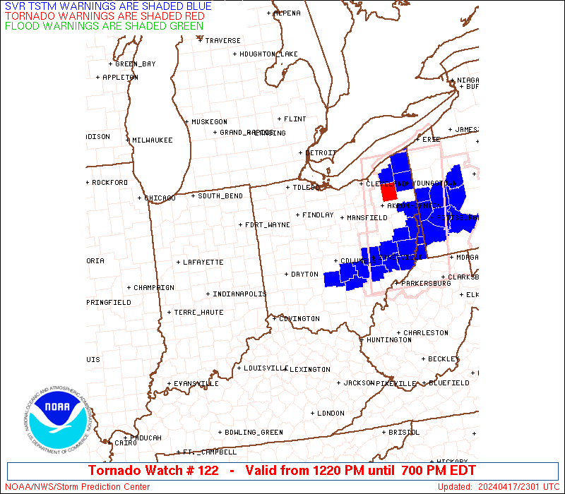
Watch 122 Status Report Messages:
STATUS REPORT #5 ON WW 122
VALID 172230Z - 172340Z
SEVERE WEATHER THREAT CONTINUES RIGHT OF A LINE FROM 45 ESE DAY
TO 10 ENE CMH TO 35 SE MFD TO 20 W CAK TO 10 NE CLE TO 25 NNE CLE.
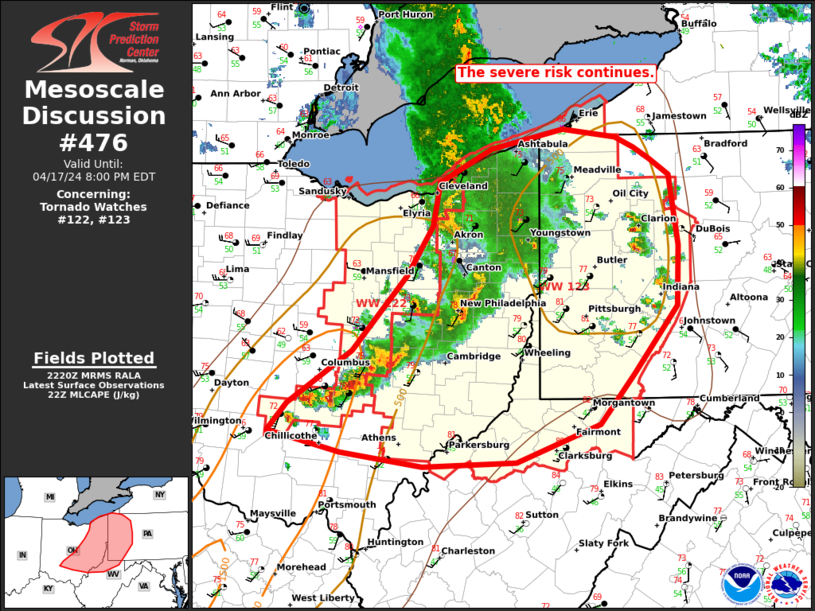
FOR ADDITIONAL INFORMATION SEE MESOSCALE DISCUSSION 476
..LYONS..04/17/24
ATTN...WFO...IWX...IND...ILN...CLE...
&&
STATUS REPORT FOR WT 122
SEVERE WEATHER THREAT CONTINUES FOR THE FOLLOWING AREAS
OHC035-045-047-075-089-103-129-169-172340-
OH
. OHIO COUNTIES INCLUDED ARE
CUYAHOGA FAIRFIELD FAYETTE
HOLMES LICKING MEDINA
PICKAWAY WAYNE
$$
LEZ146-172340-
CW
. ADJACENT COASTAL WATERS INCLUDED ARE
AVON POINT TO WILLOWICK OH
$$
THE WATCH STATUS MESSAGE IS FOR GUIDANCE PURPOSES ONLY. PLEASE
REFER TO WATCH COUNTY NOTIFICATION STATEMENTS FOR OFFICIAL
INFORMATION ON COUNTIES...INDEPENDENT CITIES AND MARINE ZONES
CLEARED FROM SEVERE THUNDERSTORM AND TORNADO WATCHES.
$$
STATUS REPORT #4 ON WW 122
VALID 172035Z - 172140Z
SEVERE WEATHER THREAT CONTINUES RIGHT OF A LINE FROM 25 N LUK TO
15 NE DAY TO 30 WSW MFD TO 45 SE DTW.
FOR ADDITIONAL INFORMATION SEE MESOSCALE DISCUSSION 474
..LEITMAN..04/17/24
ATTN...WFO...IWX...IND...ILN...CLE...
&&
STATUS REPORT FOR WT 122
SEVERE WEATHER THREAT CONTINUES FOR THE FOLLOWING AREAS
OHC005-021-023-027-033-035-041-043-045-047-049-057-075-077-083-
089-093-097-101-103-117-129-139-159-165-169-172140-
OH
. OHIO COUNTIES INCLUDED ARE
ASHLAND CHAMPAIGN CLARK
CLINTON CRAWFORD CUYAHOGA
DELAWARE ERIE FAIRFIELD
FAYETTE FRANKLIN GREENE
HOLMES HURON KNOX
LICKING LORAIN MADISON
MARION MEDINA MORROW
PICKAWAY RICHLAND UNION
WARREN WAYNE
$$
LEZ143-144-145-146-172140-
CW
. ADJACENT COASTAL WATERS INCLUDED ARE
RENO BEACH TO THE ISLANDS OH
THE ISLANDS TO VERMILION OH
VERMILION TO AVON POINT OH
AVON POINT TO WILLOWICK OH
$$
THE WATCH STATUS MESSAGE IS FOR GUIDANCE PURPOSES ONLY. PLEASE
REFER TO WATCH COUNTY NOTIFICATION STATEMENTS FOR OFFICIAL
INFORMATION ON COUNTIES...INDEPENDENT CITIES AND MARINE ZONES
CLEARED FROM SEVERE THUNDERSTORM AND TORNADO WATCHES.
$$
STATUS REPORT #3 ON WW 122
VALID 171925Z - 172040Z
SEVERE WEATHER THREAT CONTINUES RIGHT OF A LINE FROM 25 WNW LUK
TO 25 N DAY TO 20 SE FDY TO 20 E TOL TO 25 SSE ARB.
..LEITMAN..04/17/24
ATTN...WFO...IWX...IND...ILN...CLE...
&&
STATUS REPORT FOR WT 122
SEVERE WEATHER THREAT CONTINUES FOR THE FOLLOWING AREAS
OHC005-017-021-023-027-033-035-041-043-045-047-049-057-065-075-
077-083-089-091-093-097-101-103-109-113-117-123-129-135-139-143-
147-149-159-165-169-175-172040-
OH
. OHIO COUNTIES INCLUDED ARE
ASHLAND BUTLER CHAMPAIGN
CLARK CLINTON CRAWFORD
CUYAHOGA DELAWARE ERIE
FAIRFIELD FAYETTE FRANKLIN
GREENE HARDIN HOLMES
HURON KNOX LICKING
LOGAN LORAIN MADISON
MARION MEDINA MIAMI
MONTGOMERY MORROW OTTAWA
PICKAWAY PREBLE RICHLAND
SANDUSKY SENECA SHELBY
UNION WARREN WAYNE
WYANDOT
$$
LEZ142-143-144-145-146-172040-
CW
. ADJACENT COASTAL WATERS INCLUDED ARE
MAUMEE BAY TO RENO BEACH OH
RENO BEACH TO THE ISLANDS OH
THE ISLANDS TO VERMILION OH
VERMILION TO AVON POINT OH
AVON POINT TO WILLOWICK OH
$$
THE WATCH STATUS MESSAGE IS FOR GUIDANCE PURPOSES ONLY. PLEASE
REFER TO WATCH COUNTY NOTIFICATION STATEMENTS FOR OFFICIAL
INFORMATION ON COUNTIES...INDEPENDENT CITIES AND MARINE ZONES
CLEARED FROM SEVERE THUNDERSTORM AND TORNADO WATCHES.
$$
STATUS REPORT #2 ON WW 122
VALID 171825Z - 171940Z
SEVERE WEATHER THREAT CONTINUES RIGHT OF A LINE FROM 50 S MIE TO
20 ENE MIE TO 40 WSW FDY TO 30 S JXN.
FOR ADDITIONAL INFORMATION SEE MESOSCALE DISCUSSION 472.
..LEITMAN..04/17/24
ATTN...WFO...IWX...IND...ILN...CLE...
&&
STATUS REPORT FOR WT 122
SEVERE WEATHER THREAT CONTINUES FOR THE FOLLOWING AREAS
INC041-047-135-161-177-171940-
IN
. INDIANA COUNTIES INCLUDED ARE
FAYETTE FRANKLIN RANDOLPH
UNION WAYNE
$$
OHC003-005-011-017-021-023-027-033-035-037-041-043-045-047-049-
051-057-063-065-069-075-077-083-089-091-093-095-097-101-103-107-
109-113-117-123-129-135-137-139-143-147-149-159-165-169-173-175-
171940-
OH
. OHIO COUNTIES INCLUDED ARE
ALLEN ASHLAND AUGLAIZE
BUTLER CHAMPAIGN CLARK
CLINTON CRAWFORD CUYAHOGA
DARKE DELAWARE ERIE
FAIRFIELD FAYETTE FRANKLIN
FULTON GREENE HANCOCK
HARDIN HENRY HOLMES
HURON KNOX LICKING
LOGAN LORAIN LUCAS
MADISON MARION MEDINA
MERCER MIAMI MONTGOMERY
MORROW OTTAWA PICKAWAY
PREBLE PUTNAM RICHLAND
SANDUSKY SENECA SHELBY
UNION WARREN WAYNE
WOOD WYANDOT
$$
LEZ142-143-144-145-146-171940-
CW
. ADJACENT COASTAL WATERS INCLUDED ARE
MAUMEE BAY TO RENO BEACH OH
RENO BEACH TO THE ISLANDS OH
THE ISLANDS TO VERMILION OH
VERMILION TO AVON POINT OH
AVON POINT TO WILLOWICK OH
$$
THE WATCH STATUS MESSAGE IS FOR GUIDANCE PURPOSES ONLY. PLEASE
REFER TO WATCH COUNTY NOTIFICATION STATEMENTS FOR OFFICIAL
INFORMATION ON COUNTIES...INDEPENDENT CITIES AND MARINE ZONES
CLEARED FROM SEVERE THUNDERSTORM AND TORNADO WATCHES.
$$
STATUS REPORT #1 ON WW 122
VALID 171730Z - 171840Z
SEVERE WEATHER THREAT CONTINUES RIGHT OF A LINE FROM 30 WNW MIE
TO 20 NNW MIE TO 40 SW JXN.
..LEITMAN..04/17/24
ATTN...WFO...IWX...IND...ILN...CLE...
&&
STATUS REPORT FOR WT 122
SEVERE WEATHER THREAT CONTINUES FOR THE FOLLOWING AREAS
INC001-003-009-033-035-041-047-059-065-075-095-135-139-151-161-
177-179-171840-
IN
. INDIANA COUNTIES INCLUDED ARE
ADAMS ALLEN BLACKFORD
DE KALB DELAWARE FAYETTE
FRANKLIN HANCOCK HENRY
JAY MADISON RANDOLPH
RUSH STEUBEN UNION
WAYNE WELLS
$$
OHC003-005-011-017-021-023-027-033-035-037-039-041-043-045-047-
049-051-057-063-065-069-075-077-083-089-091-093-095-097-101-103-
107-109-113-117-123-125-129-135-137-139-143-147-149-159-161-165-
169-171-173-175-171840-
OH
. OHIO COUNTIES INCLUDED ARE
ALLEN ASHLAND AUGLAIZE
BUTLER CHAMPAIGN CLARK
CLINTON CRAWFORD CUYAHOGA
DARKE DEFIANCE DELAWARE
ERIE FAIRFIELD FAYETTE
FRANKLIN FULTON GREENE
HANCOCK HARDIN HENRY
HOLMES HURON KNOX
LICKING LOGAN LORAIN
LUCAS MADISON MARION
MEDINA MERCER MIAMI
MONTGOMERY MORROW OTTAWA
PAULDING PICKAWAY PREBLE
PUTNAM RICHLAND SANDUSKY
SENECA SHELBY UNION
VAN WERT WARREN WAYNE
WILLIAMS WOOD WYANDOT
$$
LEZ142-143-144-145-146-171840-
CW
. ADJACENT COASTAL WATERS INCLUDED ARE
MAUMEE BAY TO RENO BEACH OH
RENO BEACH TO THE ISLANDS OH
THE ISLANDS TO VERMILION OH
VERMILION TO AVON POINT OH
AVON POINT TO WILLOWICK OH
$$
THE WATCH STATUS MESSAGE IS FOR GUIDANCE PURPOSES ONLY. PLEASE
REFER TO WATCH COUNTY NOTIFICATION STATEMENTS FOR OFFICIAL
INFORMATION ON COUNTIES...INDEPENDENT CITIES AND MARINE ZONES
CLEARED FROM SEVERE THUNDERSTORM AND TORNADO WATCHES.
$$
Note:
Click for Complete Product Text.
Tornadoes
Probability of 2 or more tornadoes
|
Mod (40%)
|
Probability of 1 or more strong (EF2-EF5) tornadoes
|
Low (20%)
|
Wind
Probability of 10 or more severe wind events
|
Mod (40%)
|
Probability of 1 or more wind events > 65 knots
|
Low (20%)
|
Hail
Probability of 10 or more severe hail events
|
Mod (40%)
|
Probability of 1 or more hailstones > 2 inches
|
Low (20%)
|
Combined Severe Hail/Wind
Probability of 6 or more combined severe hail/wind events
|
High (70%)
|
For each watch, probabilities for particular events inside the watch
(listed above in each table) are determined by the issuing forecaster.
The "Low" category contains probability values ranging from less than 2%
to 20% (EF2-EF5 tornadoes), less than 5% to 20% (all other probabilities),
"Moderate" from 30% to 60%, and "High" from 70% to greater than 95%.
High values are bolded and lighter in color to provide awareness of
an increased threat for a particular event.


 @NWSSPC