 Note:
The expiration time in the watch graphic is amended if the watch is
replaced, cancelled or extended.
Note:
Note:
The expiration time in the watch graphic is amended if the watch is
replaced, cancelled or extended.
Note: Click for
Watch Status Reports.
SEL4
URGENT - IMMEDIATE BROADCAST REQUESTED
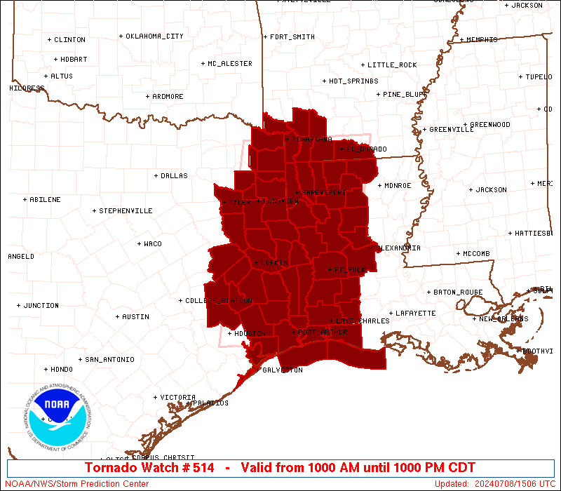
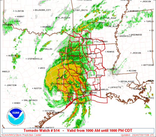
Tornado Watch Number 514
NWS Storm Prediction Center Norman OK
1000 AM CDT Mon Jul 8 2024
The NWS Storm Prediction Center has issued a
* Tornado Watch for portions of
Southern Arkansas
Western and Central Louisiana
East and Southeast Texas
Coastal Waters
* Effective this Monday morning and evening from 1000 AM until
1000 PM CDT.
* Primary threats include...
Several tornadoes likely
Isolated damaging wind gusts to 70 mph possible
SUMMARY...Gradual daytime destabilization and a strong atmospheric
winds associated with the northward movement of Tropical cyclone
Beryl will be favorable for low-topped supercells capable of
tornadoes through this afternoon and early evening. This risk will
mostly be focused across east/southeast Texas and far western
Louisiana this morning, but it will expand north-northeastward
across additional parts of east/northeast Texas, western/northern
Louisiana, and eventually southern Arkansas through late afternoon
and evening.
The tornado watch area is approximately along and 80 statute miles
east and west of a line from 20 miles southwest of Port Arthur TX to
45 miles west northwest of El Dorado AR. For a complete depiction of
the watch see the associated watch outline update (WOUS64 KWNS
WOU4).
PRECAUTIONARY/PREPAREDNESS ACTIONS...
REMEMBER...A Tornado Watch means conditions are favorable for
tornadoes and severe thunderstorms in and close to the watch
area. Persons in these areas should be on the lookout for
threatening weather conditions and listen for later statements
and possible warnings.
&&
OTHER WATCH INFORMATION...CONTINUE...WW 513...
AVIATION...Tornadoes and a few severe thunderstorms with hail
surface and aloft to 0 inches. Extreme turbulence and surface wind
gusts to 60 knots. A few cumulonimbi with maximum tops to 500. Mean
storm motion vector 16040.
...Guyer

   SEL4

   URGENT - IMMEDIATE BROADCAST REQUESTED
   Tornado Watch Number 514
   NWS Storm Prediction Center Norman OK
   1000 AM CDT Mon Jul 8 2024

   The NWS Storm Prediction Center has issued a

   * Tornado Watch for portions of
     Southern Arkansas
     Western and Central Louisiana
     East and Southeast Texas
     Coastal Waters

   * Effective this Monday morning and evening from 1000 AM until
     1000 PM CDT.

   * Primary threats include...
     Several tornadoes likely
     Isolated damaging wind gusts to 70 mph possible

   SUMMARY...Gradual daytime destabilization and a strong atmospheric
   winds associated with the northward movement of Tropical cyclone
   Beryl will be favorable for low-topped supercells capable of
   tornadoes through this afternoon and early evening. This risk will
   mostly be focused across east/southeast Texas and far western
   Louisiana this morning, but it will expand north-northeastward
   across additional parts of east/northeast Texas, western/northern
   Louisiana, and eventually southern Arkansas through late afternoon
   and evening.

   The tornado watch area is approximately along and 80 statute miles
   east and west of a line from 20 miles southwest of Port Arthur TX to
   45 miles west northwest of El Dorado AR. For a complete depiction of
   the watch see the associated watch outline update (WOUS64 KWNS
   WOU4).

   PRECAUTIONARY/PREPAREDNESS ACTIONS...

   REMEMBER...A Tornado Watch means conditions are favorable for
   tornadoes and severe thunderstorms in and close to the watch
   area. Persons in these areas should be on the lookout for
   threatening weather conditions and listen for later statements
   and possible warnings.

   &&

   OTHER WATCH INFORMATION...CONTINUE...WW 513...

   AVIATION...Tornadoes and a few severe thunderstorms with hail
   surface and aloft to 0 inches. Extreme turbulence and surface wind
   gusts to 60 knots. A few cumulonimbi with maximum tops to 500. Mean
   storm motion vector 16040.

   ...Guyer
 Note:
The Aviation Watch (SAW) product is an approximation to the watch area.
The actual watch is depicted by the shaded areas.
Note:
The Aviation Watch (SAW) product is an approximation to the watch area.
The actual watch is depicted by the shaded areas.
   SAW4
   WW 514 TORNADO AR LA TX CW 081500Z - 090300Z
   AXIS..80 STATUTE MILES EAST AND WEST OF LINE..
   20SW BPT/PORT ARTHUR TX/ - 45WNW ELD/EL DORADO AR/
   ..AVIATION COORDS.. 70NM E/W /58ESE IAH - 27E TXK/
   WIND GUSTS..60 KNOTS.
   MAX TOPS TO 500.MEAN STORM MOTION VECTOR 16040.

   LAT...LON 29749559 33469493 33469215 29749292

   THIS IS AN APPROXIMATION TO THE WATCH AREA.  FOR A
   COMPLETE DEPICTION OF THE WATCH SEE WOUS64 KWNS
   FOR WOU4.
Watch 514 Status Report Messages:
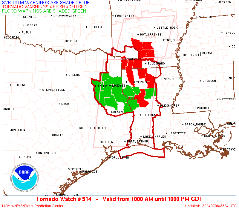
STATUS REPORT #5 ON WW 514
VALID 082025Z - 082140Z
SEVERE WEATHER THREAT CONTINUES RIGHT OF A LINE FROM 15 SSW BPT
TO 35 WSW POE TO 50 W IER TO 15 SSE GGG TO 20 ENE TYR.
..KERR..07/08/24
ATTN...WFO...SHV...LCH...HGX...
&&
STATUS REPORT FOR WT 514
SEVERE WEATHER THREAT CONTINUES FOR THE FOLLOWING AREAS
ARC027-057-073-081-091-099-139-082140-
AR
. ARKANSAS COUNTIES INCLUDED ARE
COLUMBIA HEMPSTEAD LAFAYETTE
LITTLE RIVER MILLER NEVADA
UNION
$$
LAC003-011-013-015-017-019-023-027-031-043-049-053-061-069-079-
081-085-111-115-119-127-082140-
LA
. LOUISIANA PARISHES INCLUDED ARE
ALLEN BEAUREGARD BIENVILLE
BOSSIER CADDO CALCASIEU
CAMERON CLAIBORNE DE SOTO
GRANT JACKSON JEFFERSON DAVIS
LINCOLN NATCHITOCHES RAPIDES
RED RIVER SABINE UNION
VERNON WEBSTER WINN
$$
TXC037-067-183-203-315-343-351-361-365-403-459-082140-
TX
. TEXAS COUNTIES INCLUDED ARE
BOWIE CASS GREGG
HARRISON MARION MORRIS
NEWTON ORANGE PANOLA
SABINE UPSHUR
$$
GMZ430-432-082140-
CW
. ADJACENT COASTAL WATERS INCLUDED ARE
SABINE LAKE
CALCASIEU LAKE
$$
THE WATCH STATUS MESSAGE IS FOR GUIDANCE PURPOSES ONLY. PLEASE
REFER TO WATCH COUNTY NOTIFICATION STATEMENTS FOR OFFICIAL
INFORMATION ON COUNTIES...INDEPENDENT CITIES AND MARINE ZONES
CLEARED FROM SEVERE THUNDERSTORM AND TORNADO WATCHES.
$$
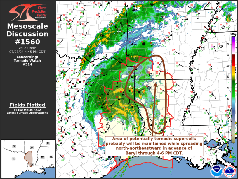
STATUS REPORT #4 ON WW 514
VALID 081950Z - 082040Z
SEVERE WEATHER THREAT CONTINUES RIGHT OF A LINE FROM 15 SSW BPT
TO 45 E LFK TO 40 ENE LFK TO 15 ENE TYR.
FOR ADDITIONAL INFORMATION SEE MESOSCALE DISCUSSION 1560.
..KERR..07/08/24
ATTN...WFO...SHV...LCH...HGX...
&&
STATUS REPORT FOR WT 514
SEVERE WEATHER THREAT CONTINUES FOR THE FOLLOWING AREAS
ARC027-057-073-081-091-099-139-082040-
AR
. ARKANSAS COUNTIES INCLUDED ARE
COLUMBIA HEMPSTEAD LAFAYETTE
LITTLE RIVER MILLER NEVADA
UNION
$$
LAC003-011-013-015-017-019-023-027-031-043-049-053-061-069-079-
081-085-111-115-119-127-082040-
LA
. LOUISIANA PARISHES INCLUDED ARE
ALLEN BEAUREGARD BIENVILLE
BOSSIER CADDO CALCASIEU
CAMERON CLAIBORNE DE SOTO
GRANT JACKSON JEFFERSON DAVIS
LINCOLN NATCHITOCHES RAPIDES
RED RIVER SABINE UNION
VERNON WEBSTER WINN
$$
TXC037-067-183-203-315-343-351-361-365-401-403-419-459-082040-
TX
. TEXAS COUNTIES INCLUDED ARE
BOWIE CASS GREGG
HARRISON MARION MORRIS
NEWTON ORANGE PANOLA
RUSK SABINE SHELBY
UPSHUR
$$
GMZ430-432-082040-
CW
. ADJACENT COASTAL WATERS INCLUDED ARE
SABINE LAKE
CALCASIEU LAKE
$$
THE WATCH STATUS MESSAGE IS FOR GUIDANCE PURPOSES ONLY. PLEASE
REFER TO WATCH COUNTY NOTIFICATION STATEMENTS FOR OFFICIAL
INFORMATION ON COUNTIES...INDEPENDENT CITIES AND MARINE ZONES
CLEARED FROM SEVERE THUNDERSTORM AND TORNADO WATCHES.
$$
STATUS REPORT #3 ON WW 514
VALID 081825Z - 081940Z
SEVERE WEATHER THREAT CONTINUES RIGHT OF A LINE FROM 15 SSW BPT
TO 30 ESE LFK TO 40 N LFK TO 30 SSE TYR.
..KERR..07/08/24
ATTN...WFO...SHV...LCH...HGX...
&&
STATUS REPORT FOR WT 514
SEVERE WEATHER THREAT CONTINUES FOR THE FOLLOWING AREAS
ARC027-057-073-081-091-099-139-081940-
AR
. ARKANSAS COUNTIES INCLUDED ARE
COLUMBIA HEMPSTEAD LAFAYETTE
LITTLE RIVER MILLER NEVADA
UNION
$$
LAC003-011-013-015-017-019-023-027-031-043-049-053-061-069-079-
081-085-111-115-119-127-081940-
LA
. LOUISIANA PARISHES INCLUDED ARE
ALLEN BEAUREGARD BIENVILLE
BOSSIER CADDO CALCASIEU
CAMERON CLAIBORNE DE SOTO
GRANT JACKSON JEFFERSON DAVIS
LINCOLN NATCHITOCHES RAPIDES
RED RIVER SABINE UNION
VERNON WEBSTER WINN
$$
TXC037-067-183-203-241-315-343-351-361-365-401-403-405-419-423-
459-081940-
TX
. TEXAS COUNTIES INCLUDED ARE
BOWIE CASS GREGG
HARRISON JASPER MARION
MORRIS NEWTON ORANGE
PANOLA RUSK SABINE
SAN AUGUSTINE SHELBY SMITH
UPSHUR
$$
GMZ430-432-081940-
CW
. ADJACENT COASTAL WATERS INCLUDED ARE
SABINE LAKE
CALCASIEU LAKE
$$
THE WATCH STATUS MESSAGE IS FOR GUIDANCE PURPOSES ONLY. PLEASE
REFER TO WATCH COUNTY NOTIFICATION STATEMENTS FOR OFFICIAL
INFORMATION ON COUNTIES...INDEPENDENT CITIES AND MARINE ZONES
CLEARED FROM SEVERE THUNDERSTORM AND TORNADO WATCHES.
$$
STATUS REPORT #2 ON WW 514
VALID 081725Z - 081840Z
SEVERE WEATHER THREAT CONTINUES RIGHT OF A LINE FROM 20 SW BPT TO
30 SE LFK TO 40 NW LFK.
..KERR..07/08/24
ATTN...WFO...SHV...LCH...HGX...
&&
STATUS REPORT FOR WT 514
SEVERE WEATHER THREAT CONTINUES FOR THE FOLLOWING AREAS
ARC027-057-073-081-091-099-139-081840-
AR
. ARKANSAS COUNTIES INCLUDED ARE
COLUMBIA HEMPSTEAD LAFAYETTE
LITTLE RIVER MILLER NEVADA
UNION
$$
LAC003-011-013-015-017-019-023-027-031-043-049-053-061-069-079-
081-085-111-115-119-127-081840-
LA
. LOUISIANA PARISHES INCLUDED ARE
ALLEN BEAUREGARD BIENVILLE
BOSSIER CADDO CALCASIEU
CAMERON CLAIBORNE DE SOTO
GRANT JACKSON JEFFERSON DAVIS
LINCOLN NATCHITOCHES RAPIDES
RED RIVER SABINE UNION
VERNON WEBSTER WINN
$$
TXC005-037-067-073-183-203-241-315-343-347-351-361-365-401-403-
405-419-423-457-459-081840-
TX
. TEXAS COUNTIES INCLUDED ARE
ANGELINA BOWIE CASS
CHEROKEE GREGG HARRISON
JASPER MARION MORRIS
NACOGDOCHES NEWTON ORANGE
PANOLA RUSK SABINE
SAN AUGUSTINE SHELBY SMITH
TYLER UPSHUR
$$
GMZ430-432-081840-
CW
. ADJACENT COASTAL WATERS INCLUDED ARE
SABINE LAKE
CALCASIEU LAKE
$$
THE WATCH STATUS MESSAGE IS FOR GUIDANCE PURPOSES ONLY. PLEASE
REFER TO WATCH COUNTY NOTIFICATION STATEMENTS FOR OFFICIAL
INFORMATION ON COUNTIES...INDEPENDENT CITIES AND MARINE ZONES
CLEARED FROM SEVERE THUNDERSTORM AND TORNADO WATCHES.
$$
STATUS REPORT #1 ON WW 514
VALID 081625Z - 081740Z
SEVERE WEATHER THREAT CONTINUES RIGHT OF A LINE FROM 30 N GLS TO
45 ESE UTS TO 15 NNE UTS.
FOR ADDITIONAL INFORMATION SEE MESOSCALE DISCUSSION 1558.
..KERR..07/08/24
ATTN...WFO...SHV...LCH...HGX...
&&
STATUS REPORT FOR WT 514
SEVERE WEATHER THREAT CONTINUES FOR THE FOLLOWING AREAS
ARC027-057-073-081-091-099-139-081740-
AR
. ARKANSAS COUNTIES INCLUDED ARE
COLUMBIA HEMPSTEAD LAFAYETTE
LITTLE RIVER MILLER NEVADA
UNION
$$
LAC003-011-013-015-017-019-023-027-031-043-049-053-061-069-079-
081-085-111-115-119-127-081740-
LA
. LOUISIANA PARISHES INCLUDED ARE
ALLEN BEAUREGARD BIENVILLE
BOSSIER CADDO CALCASIEU
CAMERON CLAIBORNE DE SOTO
GRANT JACKSON JEFFERSON DAVIS
LINCOLN NATCHITOCHES RAPIDES
RED RIVER SABINE UNION
VERNON WEBSTER WINN
$$
TXC005-037-067-071-073-183-199-203-225-241-245-315-343-347-351-
361-365-373-401-403-405-419-423-455-457-459-081740-
TX
. TEXAS COUNTIES INCLUDED ARE
ANGELINA BOWIE CASS
CHAMBERS CHEROKEE GREGG
HARDIN HARRISON HOUSTON
JASPER JEFFERSON MARION
MORRIS NACOGDOCHES NEWTON
ORANGE PANOLA POLK
RUSK SABINE SAN AUGUSTINE
SHELBY SMITH TRINITY
TYLER UPSHUR
$$
GMZ335-430-432-450-452-081740-
CW
. ADJACENT COASTAL WATERS INCLUDED ARE
GALVESTON BAY
SABINE LAKE
CALCASIEU LAKE
COASTAL WATERS FROM CAMERON LA TO HIGH ISLAND TX OUT 20 NM
COASTAL WATERS FROM INTRACOASTAL CITY TO CAMERON LA OUT 20 NM
$$
THE WATCH STATUS MESSAGE IS FOR GUIDANCE PURPOSES ONLY. PLEASE
REFER TO WATCH COUNTY NOTIFICATION STATEMENTS FOR OFFICIAL
INFORMATION ON COUNTIES...INDEPENDENT CITIES AND MARINE ZONES
CLEARED FROM SEVERE THUNDERSTORM AND TORNADO WATCHES.
$$
Note:
Click for Complete Product Text.
Tornadoes
Probability of 2 or more tornadoes
|
High (80%)
|
Probability of 1 or more strong (EF2-EF5) tornadoes
|
Low (20%)
|
Wind
Probability of 10 or more severe wind events
|
Low (20%)
|
Probability of 1 or more wind events > 65 knots
|
Low (<5%)
|
Hail
Probability of 10 or more severe hail events
|
Low (<5%)
|
Probability of 1 or more hailstones > 2 inches
|
Low (<5%)
|
Combined Severe Hail/Wind
Probability of 6 or more combined severe hail/wind events
|
Mod (30%)
|
For each watch, probabilities for particular events inside the watch
(listed above in each table) are determined by the issuing forecaster.
The "Low" category contains probability values ranging from less than 2%
to 20% (EF2-EF5 tornadoes), less than 5% to 20% (all other probabilities),
"Moderate" from 30% to 60%, and "High" from 70% to greater than 95%.
High values are bolded and lighter in color to provide awareness of
an increased threat for a particular event.


 @NWSSPC