|
| Mesoscale Discussion 1560 |
|
< Previous MD
|
|
Mesoscale Discussion 1560
NWS Storm Prediction Center Norman OK
0248 PM CDT Mon Jul 08 2024
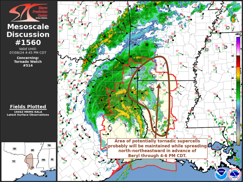
Areas affected...parts of northeastern Texas...western
Louisiana...southwestern Arkansas
Concerning...Tornado Watch 514...
Valid 081948Z - 082145Z
The severe weather threat for Tornado Watch 514 continues.
SUMMARY...An area of potentially tornadic supercells probably will
be maintained while spreading north-northeastward in advance of the
remnants of Beryl through 4-6 PM CDT. An additional tornado watch
may be needed across parts of southwestern into central Arkansas
shortly.
DISCUSSION...The low-level circulation center of Beryl is now
migrating north-northeast of Huntsville, with strongest 2 hour
surface pressure rises now inland of the upper Texas coast and falls
north of Huntsville shifting toward the Ark-La-Tex. Beneath the
mid-level warm core, evaporatively cooled air is spreading out at
the surface and stabilizing an enlarging area of eastern Texas.
However, upper 70s surface dew points on its northeastern and
eastern periphery are maintaining weak to moderate CAPE, in the
presence of large clockwise-curved low-level hodographs beneath 50+
kt south to southeasterly flow around 850 mb.
This has contributed to the evolution of a number of confirmed and
potentially tornadic supercells, largely focused within the more
strongly convergent right front quadrant (with respect to storm
motion). While this forcing spreads north through east of the
Shreveport vicinity through much of southwestern Arkansas by 21-23Z,
the risk for tornadoes appears likely to persist in the peak late
afternoon boundary-layer instability.
..Kerr.. 07/08/2024
...Please see www.spc.noaa.gov for graphic product...
ATTN...WFO...LZK...LCH...SHV...
LAT...LON 33569395 33869261 30959252 30869322 31789352 32409450
33569395
|
|
Top/All Mesoscale Discussions/Forecast Products/Home
|
|


 @NWSSPC