Note:
The expiration time in the watch graphic is amended if the watch is
replaced, cancelled or extended.
Note:
Note:
The expiration time in the watch graphic is amended if the watch is
replaced, cancelled or extended.
Note: Click for
Watch Status Reports.
SEL3
URGENT - IMMEDIATE BROADCAST REQUESTED
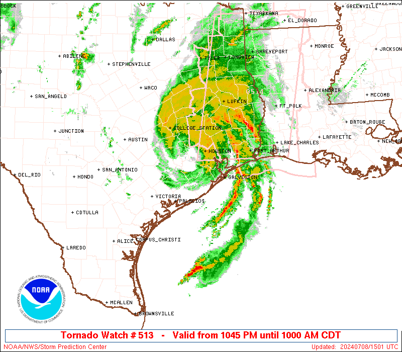
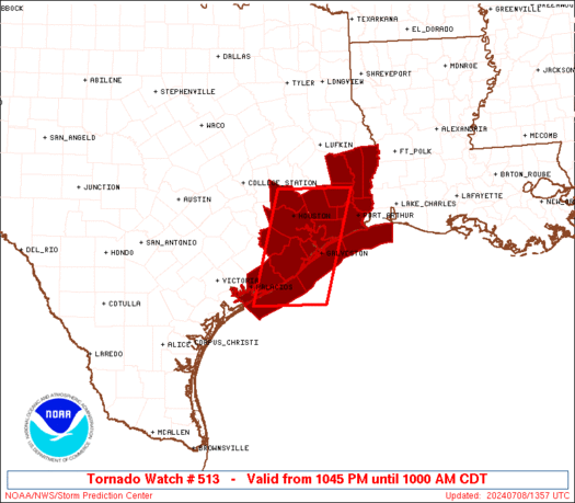
Tornado Watch Number 513
NWS Storm Prediction Center Norman OK
1045 PM CDT Sun Jul 7 2024
The NWS Storm Prediction Center has issued a
* Tornado Watch for portions of
Upper Texas Coast
Coastal Waters
* Effective this Sunday night and Monday morning from 1045 PM
until 1000 AM CDT.
* Primary threats include...
A couple tornadoes possible
Isolated damaging wind gusts to 70 mph possible
SUMMARY...Tropical Storm Beryl will move ashore overnight. Embedded
thunderstorms in the rainbands to the east of the center will pose a
risk of isolated tornadoes through Monday morning.
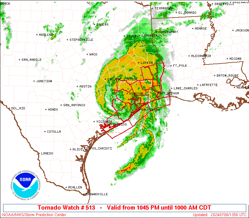
The tornado watch area is approximately along and 45 statute miles
east and west of a line from 50 miles south of Angleton TX to 60
miles north northeast of Houston TX. For a complete depiction of the
watch see the associated watch outline update (WOUS64 KWNS WOU3).
PRECAUTIONARY/PREPAREDNESS ACTIONS...
REMEMBER...A Tornado Watch means conditions are favorable for
tornadoes and severe thunderstorms in and close to the watch
area. Persons in these areas should be on the lookout for
threatening weather conditions and listen for later statements
and possible warnings.
&&
OTHER WATCH INFORMATION...CONTINUE...WW 511...WW 512...
AVIATION...Tornadoes and a few severe thunderstorms with hail
surface and aloft to 0.5 inches. Extreme turbulence and surface wind
gusts to 60 knots. A few cumulonimbi with maximum tops to 500. Mean
storm motion vector 14040.
...Hart
 Note:
The Aviation Watch (SAW) product is an approximation to the watch area.
The actual watch is depicted by the shaded areas.
Note:
The Aviation Watch (SAW) product is an approximation to the watch area.
The actual watch is depicted by the shaded areas.
   SAW3
   WW 513 TORNADO TX CW 080345Z - 081500Z
   AXIS..45 STATUTE MILES EAST AND WEST OF LINE..
   50S LBX/ANGLETON TX/ - 60NNE HOU/HOUSTON TX/
   ..AVIATION COORDS.. 40NM E/W /49ESE PSX - 38NE IAH/
   HAIL SURFACE AND ALOFT..0.5 INCH. WIND GUSTS..60 KNOTS.
   MAX TOPS TO 500. MEAN STORM MOTION VECTOR 14040.

   LAT...LON 28399621 30459565 30459414 28399473

   THIS IS AN APPROXIMATION TO THE WATCH AREA.  FOR A
   COMPLETE DEPICTION OF THE WATCH SEE WOUS64 KWNS
   FOR WOU3.
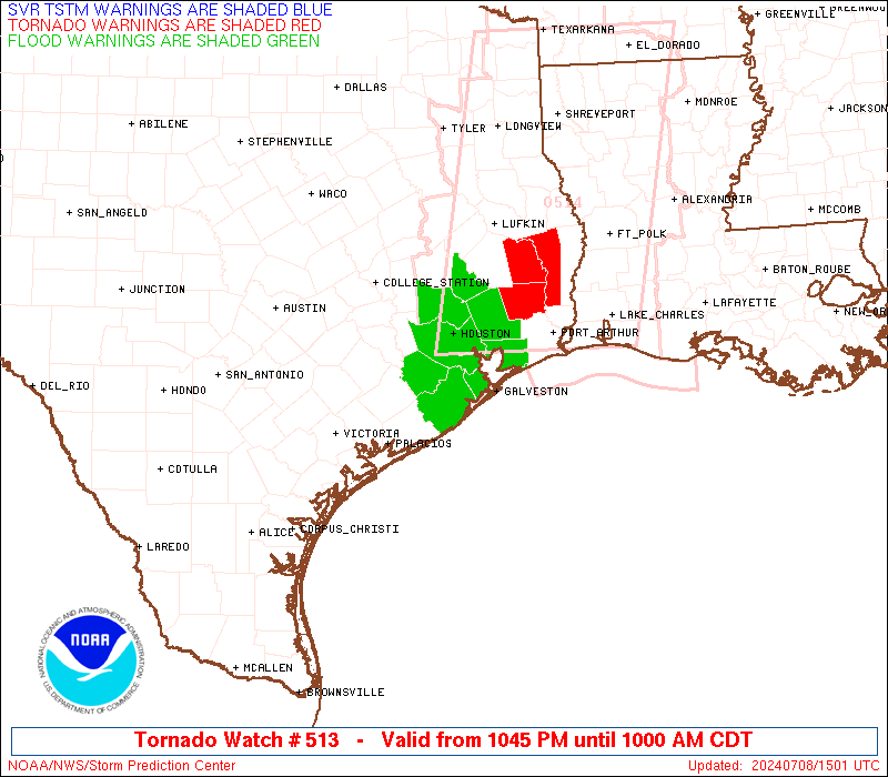
Watch 513 Status Report Messages:
STATUS REPORT #1 ON WW 513

VALID 081230Z - 081340Z

SEVERE WEATHER THREAT CONTINUES RIGHT OF A LINE FROM 50 SE PSX TO
35 S LBX TO 20 WNW LBX TO 45 S CLL.

..BENTLEY..07/08/24

ATTN...WFO...HGX...LCH...

&&

STATUS REPORT FOR WT 513

SEVERE WEATHER THREAT CONTINUES FOR THE FOLLOWING AREAS

TXC039-071-157-167-199-201-245-291-339-081340-

TX
.    TEXAS COUNTIES INCLUDED ARE

BRAZORIA	     CHAMBERS		 FORT BEND
GALVESTON	     HARDIN		 HARRIS
JEFFERSON	     LIBERTY		 MONTGOMERY
$$


GMZ335-355-450-081340-

CW

.    ADJACENT COASTAL WATERS INCLUDED ARE

GALVESTON BAY

COASTAL WATERS FROM HIGH ISLAND TO FREEPORT TX OUT 20 NM

COASTAL WATERS FROM CAMERON LA TO HIGH ISLAND TX OUT 20 NM

$$
THE WATCH STATUS MESSAGE IS FOR GUIDANCE PURPOSES ONLY.  PLEASE
REFER TO WATCH COUNTY NOTIFICATION STATEMENTS FOR OFFICIAL
INFORMATION ON COUNTIES...INDEPENDENT CITIES AND MARINE ZONES
CLEARED FROM SEVERE THUNDERSTORM AND TORNADO WATCHES.
$$
Note:
Click for Complete Product Text.
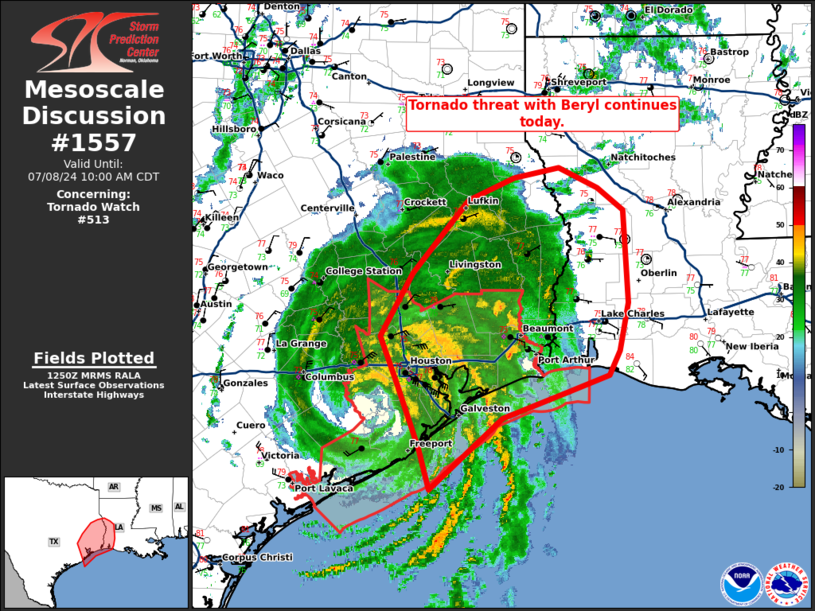
Tornadoes
Probability of 2 or more tornadoes
|
Mod (40%)
|
Probability of 1 or more strong (EF2-EF5) tornadoes
|
Low (20%)
|
Wind
Probability of 10 or more severe wind events
|
Low (20%)
|
Probability of 1 or more wind events > 65 knots
|
Low (10%)
|
Hail
Probability of 10 or more severe hail events
|
Low (<5%)
|
Probability of 1 or more hailstones > 2 inches
|
Low (<5%)
|
Combined Severe Hail/Wind
Probability of 6 or more combined severe hail/wind events
|
Mod (30%)
|
For each watch, probabilities for particular events inside the watch
(listed above in each table) are determined by the issuing forecaster.
The "Low" category contains probability values ranging from less than 2%
to 20% (EF2-EF5 tornadoes), less than 5% to 20% (all other probabilities),
"Moderate" from 30% to 60%, and "High" from 70% to greater than 95%.
High values are bolded and lighter in color to provide awareness of
an increased threat for a particular event.


 @NWSSPC