|
| Mesoscale Discussion 1557 |
|
< Previous MD Next MD >
|
|
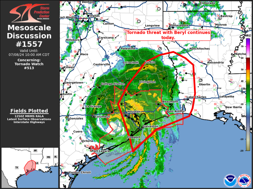
   Mesoscale Discussion 1557
   NWS Storm Prediction Center Norman OK
   0753 AM CDT Mon Jul 08 2024

   Areas affected...southeast Texas and southwest Louisiana

   Concerning...Tornado Watch 513...

   Valid 081253Z - 081500Z

   The severe weather threat for Tornado Watch 513 continues.

   SUMMARY...The tornado threat with Beryl continues today.

   DISCUSSION...Currently the primary tornado threat is associated with
   a few bands of supercells across southeast Texas. Some guidance
   indicates more cellular convection across southwest Louisiana and
   eastern Texas by later this morning which could pose some tornado
   threat given the wind profile shown by the LCH VWP. Therefore, when
   tornado watch 513 expires at 15Z, a new watch may be needed which
   may also need to be expanded farther inland to cover this threat as
   it develops northward through the day.

   ..Bentley/Smith.. 07/08/2024

   ...Please see www.spc.noaa.gov for graphic product...

   ATTN...WFO...LCH...SHV...HGX...

   LAT...LON   28569511 28989524 29639549 30079568 30689532 31419468
               31629417 31739365 31539322 31309293 30399288 29929298
               29689310 29529356 29279430 28569511
|
|
Top/All Mesoscale Discussions/Forecast Products/Home
|
|


 @NWSSPC