Note:
The expiration time in the watch graphic is amended if the watch is
replaced, cancelled or extended.
Note:
Note:
The expiration time in the watch graphic is amended if the watch is
replaced, cancelled or extended.
Note: Click for
Watch Status Reports.
SEL1
URGENT - IMMEDIATE BROADCAST REQUESTED
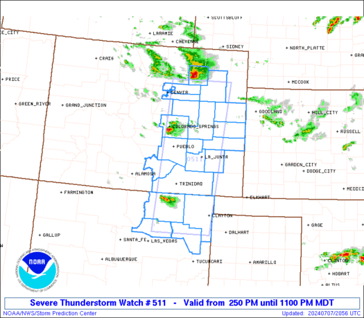
Severe Thunderstorm Watch Number 511
NWS Storm Prediction Center Norman OK
250 PM MDT Sun Jul 7 2024
The NWS Storm Prediction Center has issued a
* Severe Thunderstorm Watch for portions of
Eastern Colorado
Northeast New Mexico
* Effective this Sunday afternoon and evening from 250 PM until
1100 PM MDT.
* Primary threats include...
Scattered large hail likely with isolated very large hail events
to 2 inches in diameter possible
Isolated damaging wind gusts to 70 mph possible
A tornado or two possible
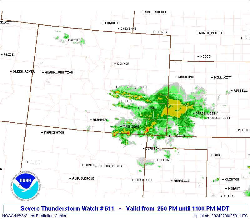
SUMMARY...Scattered strong to severe thunderstorms will develop and
increase through late afternoon and early evening, initially
including areas near/east of the I-25 corridor across eastern
Colorado and northeast New Mexico. These storms will be capable of
large hail, and severe-wind potential may also increase as storms
cluster into this evening.
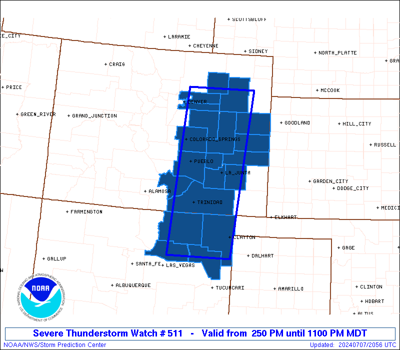
The severe thunderstorm watch area is approximately along and 55
statute miles east and west of a line from 60 miles north of Limon
CO to 60 miles south southeast of Raton NM. For a complete depiction
of the watch see the associated watch outline update (WOUS64 KWNS
WOU1).
PRECAUTIONARY/PREPAREDNESS ACTIONS...
REMEMBER...A Severe Thunderstorm Watch means conditions are
favorable for severe thunderstorms in and close to the watch area.
Persons in these areas should be on the lookout for threatening
weather conditions and listen for later statements and possible
warnings. Severe thunderstorms can and occasionally do produce
tornadoes.
&&
AVIATION...A few severe thunderstorms with hail surface and aloft to
2 inches. Extreme turbulence and surface wind gusts to 60 knots. A
few cumulonimbi with maximum tops to 500. Mean storm motion vector
30025.
...Guyer
   SEL1

   URGENT - IMMEDIATE BROADCAST REQUESTED
   Severe Thunderstorm Watch Number 511
   NWS Storm Prediction Center Norman OK
   250 PM MDT Sun Jul 7 2024

   The NWS Storm Prediction Center has issued a

   * Severe Thunderstorm Watch for portions of
     Eastern Colorado
     Northeast New Mexico

   * Effective this Sunday afternoon and evening from 250 PM until
     1100 PM MDT.

   * Primary threats include...
     Scattered large hail likely with isolated very large hail events
       to 2 inches in diameter possible
     Isolated damaging wind gusts to 70 mph possible
     A tornado or two possible

   SUMMARY...Scattered strong to severe thunderstorms will develop and
   increase through late afternoon and early evening, initially
   including areas near/east of the I-25 corridor across eastern
   Colorado and northeast New Mexico. These storms will be capable of
   large hail, and severe-wind potential may also increase as storms
   cluster into this evening.

   The severe thunderstorm watch area is approximately along and 55
   statute miles east and west of a line from 60 miles north of Limon
   CO to 60 miles south southeast of Raton NM. For a complete depiction
   of the watch see the associated watch outline update (WOUS64 KWNS
   WOU1).

   PRECAUTIONARY/PREPAREDNESS ACTIONS...

   REMEMBER...A Severe Thunderstorm Watch means conditions are
   favorable for severe thunderstorms in and close to the watch area.
   Persons in these areas should be on the lookout for threatening
   weather conditions and listen for later statements and possible
   warnings. Severe thunderstorms can and occasionally do produce
   tornadoes.

   &&

   AVIATION...A few severe thunderstorms with hail surface and aloft to
   2 inches. Extreme turbulence and surface wind gusts to 60 knots. A
   few cumulonimbi with maximum tops to 500. Mean storm motion vector
   30025.

   ...Guyer
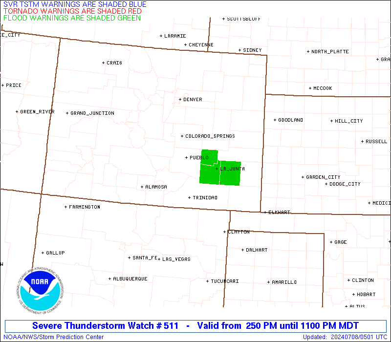
 Note:
The Aviation Watch (SAW) product is an approximation to the watch area.
The actual watch is depicted by the shaded areas.
Note:
The Aviation Watch (SAW) product is an approximation to the watch area.
The actual watch is depicted by the shaded areas.
   SAW1
   WW 511 SEVERE TSTM CO NM 072050Z - 080500Z
   AXIS..55 STATUTE MILES EAST AND WEST OF LINE..
   60N LIC/LIMON CO/ - 60SSE RTN/RATON NM/
   ..AVIATION COORDS.. 50NM E/W /23W AKO - 50NNW TCC/
   HAIL SURFACE AND ALOFT..2 INCHES. WIND GUSTS..60 KNOTS.
   MAX TOPS TO 500. MEAN STORM MOTION VECTOR 30025.

   LAT...LON 40130263 35910311 35910507 40130471

   THIS IS AN APPROXIMATION TO THE WATCH AREA.  FOR A
   COMPLETE DEPICTION OF THE WATCH SEE WOUS64 KWNS
   FOR WOU1.
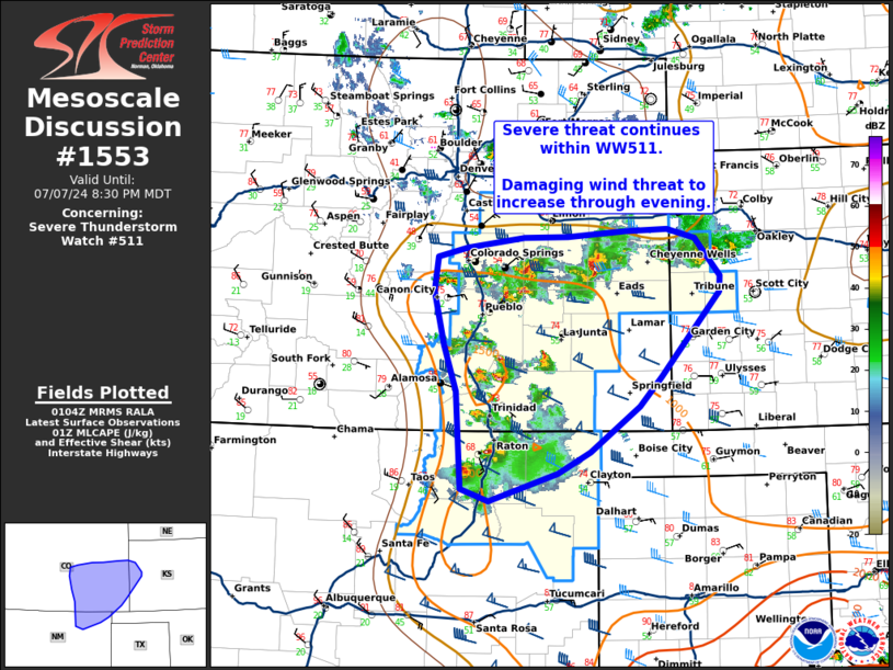
Watch 511 Status Report Messages:
STATUS REPORT #4 ON WW 511

VALID 080245Z - 080340Z

SEVERE WEATHER THREAT CONTINUES RIGHT OF A LINE FROM 45 W PUB TO
45 NE LAA TO 40 SSE GLD.

FOR ADDITIONAL INFORMATION SEE MESOSCALE DISCUSSION

..THORNTON..07/08/24

ATTN...WFO...BOU...PUB...GLD...ABQ...

&&

STATUS REPORT FOR WS 511

SEVERE WEATHER THREAT CONTINUES FOR THE FOLLOWING AREAS

COC009-011-055-071-089-099-101-080340-

CO
.    COLORADO COUNTIES INCLUDED ARE

BACA		     BENT		 HUERFANO
LAS ANIMAS	     OTERO		 PROWERS
PUEBLO
$$


KSC071-203-080340-

KS
.    KANSAS COUNTIES INCLUDED ARE

GREELEY 	     WICHITA
$$


NMC007-021-033-059-080340-

NM
.    NEW MEXICO COUNTIES INCLUDED ARE

COLFAX		     HARDING		 MORA
UNION
$$


THE WATCH STATUS MESSAGE IS FOR GUIDANCE PURPOSES ONLY.  PLEASE
REFER TO WATCH COUNTY NOTIFICATION STATEMENTS FOR OFFICIAL
INFORMATION ON COUNTIES...INDEPENDENT CITIES AND MARINE ZONES
CLEARED FROM SEVERE THUNDERSTORM AND TORNADO WATCHES.
$$

STATUS REPORT #3 ON WW 511

VALID 080045Z - 080140Z

SEVERE WEATHER THREAT CONTINUES RIGHT OF A LINE FROM 35 WNW COS
TO 10 SW GLD.

..THORNTON..07/08/24

ATTN...WFO...BOU...PUB...GLD...ABQ...

&&

STATUS REPORT FOR WS 511

SEVERE WEATHER THREAT CONTINUES FOR THE FOLLOWING AREAS

COC011-017-025-041-055-061-071-073-089-101-080140-

CO
.    COLORADO COUNTIES INCLUDED ARE

BENT		     CHEYENNE		 CROWLEY
EL PASO 	     HUERFANO		 KIOWA
LAS ANIMAS	     LINCOLN		 OTERO
PUEBLO
$$


KSC071-199-203-080140-

KS
.    KANSAS COUNTIES INCLUDED ARE

GREELEY 	     WALLACE		 WICHITA
$$


NMC007-021-033-059-080140-

NM
.    NEW MEXICO COUNTIES INCLUDED ARE

COLFAX		     HARDING		 MORA
UNION
$$


THE WATCH STATUS MESSAGE IS FOR GUIDANCE PURPOSES ONLY.  PLEASE
REFER TO WATCH COUNTY NOTIFICATION STATEMENTS FOR OFFICIAL
INFORMATION ON COUNTIES...INDEPENDENT CITIES AND MARINE ZONES
CLEARED FROM SEVERE THUNDERSTORM AND TORNADO WATCHES.
$$

STATUS REPORT #2 ON WW 511

VALID 072335Z - 080040Z

SEVERE WEATHER THREAT CONTINUES RIGHT OF A LINE FROM 35 NW COS TO
20 NNE AKO.

..THORNTON..07/07/24

ATTN...WFO...BOU...PUB...GLD...ABQ...

&&

STATUS REPORT FOR WS 511

SEVERE WEATHER THREAT CONTINUES FOR THE FOLLOWING AREAS

COC011-017-025-039-041-055-061-063-071-073-089-101-121-080040-

CO
.    COLORADO COUNTIES INCLUDED ARE

BENT		     CHEYENNE		 CROWLEY
ELBERT		     EL PASO		 HUERFANO
KIOWA		     KIT CARSON 	 LAS ANIMAS
LINCOLN 	     OTERO		 PUEBLO
WASHINGTON
$$


NMC007-021-033-059-080040-

NM
.    NEW MEXICO COUNTIES INCLUDED ARE

COLFAX		     HARDING		 MORA
UNION
$$


THE WATCH STATUS MESSAGE IS FOR GUIDANCE PURPOSES ONLY.  PLEASE
REFER TO WATCH COUNTY NOTIFICATION STATEMENTS FOR OFFICIAL
INFORMATION ON COUNTIES...INDEPENDENT CITIES AND MARINE ZONES
CLEARED FROM SEVERE THUNDERSTORM AND TORNADO WATCHES.
$$

STATUS REPORT #1 ON WW 511

VALID 072250Z - 072340Z

THE SEVERE WEATHER THREAT CONTINUES ACROSS THE ENTIRE WATCH AREA.

..THORNTON..07/07/24

ATTN...WFO...BOU...PUB...GLD...ABQ...

&&

STATUS REPORT FOR WS 511

SEVERE WEATHER THREAT CONTINUES FOR THE FOLLOWING AREAS

COC001-005-011-017-025-039-041-055-061-063-071-073-087-089-101-
121-072340-

CO
.    COLORADO COUNTIES INCLUDED ARE

ADAMS		     ARAPAHOE		 BENT
CHEYENNE	     CROWLEY		 ELBERT
EL PASO 	     HUERFANO		 KIOWA
KIT CARSON	     LAS ANIMAS 	 LINCOLN
MORGAN		     OTERO		 PUEBLO
WASHINGTON
$$


NMC007-021-033-059-072340-

NM
.    NEW MEXICO COUNTIES INCLUDED ARE

COLFAX		     HARDING		 MORA
UNION
$$


THE WATCH STATUS MESSAGE IS FOR GUIDANCE PURPOSES ONLY.  PLEASE
REFER TO WATCH COUNTY NOTIFICATION STATEMENTS FOR OFFICIAL
INFORMATION ON COUNTIES...INDEPENDENT CITIES AND MARINE ZONES
CLEARED FROM SEVERE THUNDERSTORM AND TORNADO WATCHES.
$$
Note:
Click for Complete Product Text.
Tornadoes
Probability of 2 or more tornadoes
|
Low (20%)
|
Probability of 1 or more strong (EF2-EF5) tornadoes
|
Low (5%)
|
Wind
Probability of 10 or more severe wind events
|
Mod (30%)
|
Probability of 1 or more wind events > 65 knots
|
Low (10%)
|
Hail
Probability of 10 or more severe hail events
|
High (70%)
|
Probability of 1 or more hailstones > 2 inches
|
Mod (40%)
|
Combined Severe Hail/Wind
Probability of 6 or more combined severe hail/wind events
|
High (90%)
|
For each watch, probabilities for particular events inside the watch
(listed above in each table) are determined by the issuing forecaster.
The "Low" category contains probability values ranging from less than 2%
to 20% (EF2-EF5 tornadoes), less than 5% to 20% (all other probabilities),
"Moderate" from 30% to 60%, and "High" from 70% to greater than 95%.
High values are bolded and lighter in color to provide awareness of
an increased threat for a particular event.


 @NWSSPC