 Note:
The expiration time in the watch graphic is amended if the watch is
replaced, cancelled or extended.
Note:
Note:
The expiration time in the watch graphic is amended if the watch is
replaced, cancelled or extended.
Note: Click for
Watch Status Reports.
SEL2
URGENT - IMMEDIATE BROADCAST REQUESTED
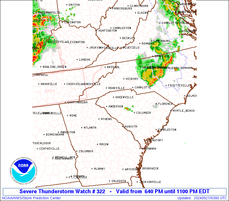
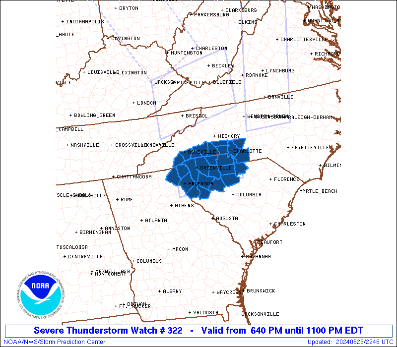
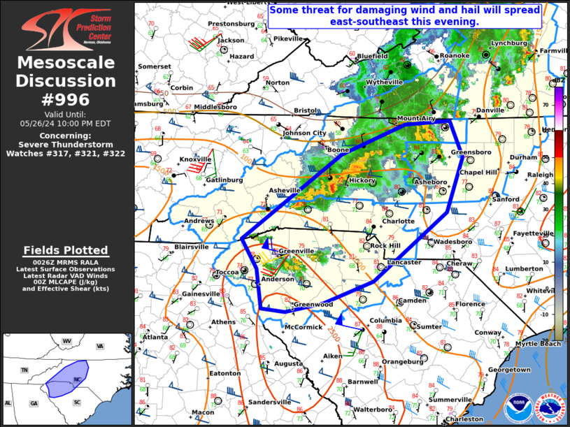
Severe Thunderstorm Watch Number 322
NWS Storm Prediction Center Norman OK
640 PM EDT Sun May 26 2024
The NWS Storm Prediction Center has issued a
* Severe Thunderstorm Watch for portions of
Western North Carolina and Piedmont
Upstate South Carolina
* Effective this Sunday evening from 640 PM until 1100 PM EDT.
* Primary threats include...
Scattered damaging wind gusts to 70 mph likely
Isolated large hail events to 1.5 inches in diameter possible
SUMMARY...Widely scattered thunderstorms are forecast to pose a
strong to severe thunderstorm risk this evening. Strong mid-level
flow will support supercell development with the stronger updrafts.
Large hail and severe gusts (55-70 mph) are the primary hazards with
the stronger storms.
The severe thunderstorm watch area is approximately along and 40
statute miles north and south of a line from 20 miles northwest of
Anderson SC to 25 miles southeast of Charlotte NC. For a complete
depiction of the watch see the associated watch outline update
(WOUS64 KWNS WOU2).
PRECAUTIONARY/PREPAREDNESS ACTIONS...
REMEMBER...A Severe Thunderstorm Watch means conditions are
favorable for severe thunderstorms in and close to the watch area.
Persons in these areas should be on the lookout for threatening
weather conditions and listen for later statements and possible
warnings. Severe thunderstorms can and occasionally do produce
tornadoes.
&&
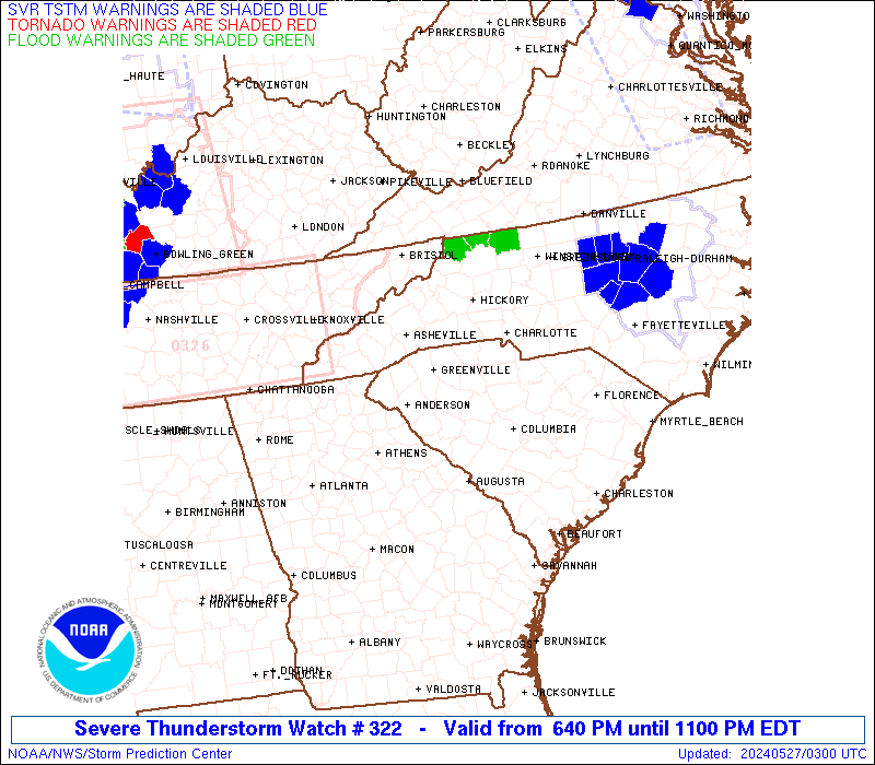
OTHER WATCH INFORMATION...CONTINUE...WW 316...WW 317...WW
318...WW 319...WW 320...WW 321...
AVIATION...A few severe thunderstorms with hail surface and aloft to
1.5 inches. Extreme turbulence and surface wind gusts to 60 knots. A
few cumulonimbi with maximum tops to 500. Mean storm motion vector
25030.
...Smith
 Note:
The Aviation Watch (SAW) product is an approximation to the watch area.
The actual watch is depicted by the shaded areas.
Note:
The Aviation Watch (SAW) product is an approximation to the watch area.
The actual watch is depicted by the shaded areas.
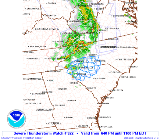
   SAW2
   WW 322 SEVERE TSTM NC SC 262240Z - 270300Z
   AXIS..40 STATUTE MILES NORTH AND SOUTH OF LINE..
   20NW AND/ANDERSON SC/ - 25SE CLT/CHARLOTTE NC/
   ..AVIATION COORDS.. 35NM N/S /16E ODF - 21SE CLT/
   HAIL SURFACE AND ALOFT..1.5 INCHES. WIND GUSTS..60 KNOTS.
   MAX TOPS TO 500. MEAN STORM MOTION VECTOR 25030.

   LAT...LON 35288297 35548064 34388064 34138297

   THIS IS AN APPROXIMATION TO THE WATCH AREA.  FOR A
   COMPLETE DEPICTION OF THE WATCH SEE WOUS64 KWNS
   FOR WOU2.
Watch 322 Status Report Messages:
STATUS REPORT #3 ON WW 322

VALID 270300Z - 270440Z

SEVERE WEATHER THREAT CONTINUES RIGHT OF A LINE FROM 45 ESE AND
TO 25 E CLT.

..LYONS..05/27/24

ATTN...WFO...GSP...CAE...

&&

STATUS REPORT FOR WS 322

SEVERE WEATHER THREAT CONTINUES FOR THE FOLLOWING AREAS

NCC179-270440-

NC
.    NORTH CAROLINA COUNTIES INCLUDED ARE

UNION
$$


SCC057-270440-

SC
.    SOUTH CAROLINA COUNTIES INCLUDED ARE

LANCASTER
$$


THE WATCH STATUS MESSAGE IS FOR GUIDANCE PURPOSES ONLY.  PLEASE
REFER TO WATCH COUNTY NOTIFICATION STATEMENTS FOR OFFICIAL
INFORMATION ON COUNTIES...INDEPENDENT CITIES AND MARINE ZONES
CLEARED FROM SEVERE THUNDERSTORM AND TORNADO WATCHES.
$$

STATUS REPORT #2 ON WW 322

VALID 270120Z - 270240Z

SEVERE WEATHER THREAT CONTINUES RIGHT OF A LINE FROM 20 NW AND TO
10 NNW GSP TO 10 ESE HKY.

..LYONS..05/27/24

ATTN...WFO...GSP...CAE...

&&

STATUS REPORT FOR WS 322

SEVERE WEATHER THREAT CONTINUES FOR THE FOLLOWING AREAS

NCC025-045-071-109-119-179-270240-

NC
.    NORTH CAROLINA COUNTIES INCLUDED ARE

CABARRUS	     CLEVELAND		 GASTON
LINCOLN 	     MECKLENBURG	 UNION
$$


SCC001-007-021-023-039-045-047-057-059-071-083-087-091-270240-

SC
.    SOUTH CAROLINA COUNTIES INCLUDED ARE

ABBEVILLE	     ANDERSON		 CHEROKEE
CHESTER 	     FAIRFIELD		 GREENVILLE
GREENWOOD	     LANCASTER		 LAURENS
NEWBERRY	     SPARTANBURG	 UNION
YORK
$$


THE WATCH STATUS MESSAGE IS FOR GUIDANCE PURPOSES ONLY.  PLEASE
REFER TO WATCH COUNTY NOTIFICATION STATEMENTS FOR OFFICIAL
INFORMATION ON COUNTIES...INDEPENDENT CITIES AND MARINE ZONES
CLEARED FROM SEVERE THUNDERSTORM AND TORNADO WATCHES.
$$

STATUS REPORT #1 ON WW 322

VALID 270020Z - 270140Z

THE SEVERE WEATHER THREAT CONTINUES ACROSS THE ENTIRE WATCH AREA.

..LYONS..05/27/24

ATTN...WFO...GSP...CAE...

&&

STATUS REPORT FOR WS 322

SEVERE WEATHER THREAT CONTINUES FOR THE FOLLOWING AREAS

NCC025-045-071-089-109-119-149-161-175-179-270140-

NC
.    NORTH CAROLINA COUNTIES INCLUDED ARE

CABARRUS	     CLEVELAND		 GASTON
HENDERSON	     LINCOLN		 MECKLENBURG
POLK		     RUTHERFORD 	 TRANSYLVANIA
UNION
$$


SCC001-007-021-023-039-045-047-057-059-071-073-077-083-087-091-
270140-

SC
.    SOUTH CAROLINA COUNTIES INCLUDED ARE

ABBEVILLE	     ANDERSON		 CHEROKEE
CHESTER 	     FAIRFIELD		 GREENVILLE
GREENWOOD	     LANCASTER		 LAURENS
NEWBERRY	     OCONEE		 PICKENS
SPARTANBURG	     UNION		 YORK
$$


THE WATCH STATUS MESSAGE IS FOR GUIDANCE PURPOSES ONLY.  PLEASE
REFER TO WATCH COUNTY NOTIFICATION STATEMENTS FOR OFFICIAL
INFORMATION ON COUNTIES...INDEPENDENT CITIES AND MARINE ZONES
CLEARED FROM SEVERE THUNDERSTORM AND TORNADO WATCHES.
$$
Note:
Click for Complete Product Text.
Tornadoes
Probability of 2 or more tornadoes
|
Low (10%)
|
Probability of 1 or more strong (EF2-EF5) tornadoes
|
Low (<2%)
|
Wind
Probability of 10 or more severe wind events
|
Mod (60%)
|
Probability of 1 or more wind events > 65 knots
|
Low (20%)
|
Hail
Probability of 10 or more severe hail events
|
Low (20%)
|
Probability of 1 or more hailstones > 2 inches
|
Low (10%)
|
Combined Severe Hail/Wind
Probability of 6 or more combined severe hail/wind events
|
High (80%)
|
For each watch, probabilities for particular events inside the watch
(listed above in each table) are determined by the issuing forecaster.
The "Low" category contains probability values ranging from less than 2%
to 20% (EF2-EF5 tornadoes), less than 5% to 20% (all other probabilities),
"Moderate" from 30% to 60%, and "High" from 70% to greater than 95%.
High values are bolded and lighter in color to provide awareness of
an increased threat for a particular event.


 @NWSSPC