|
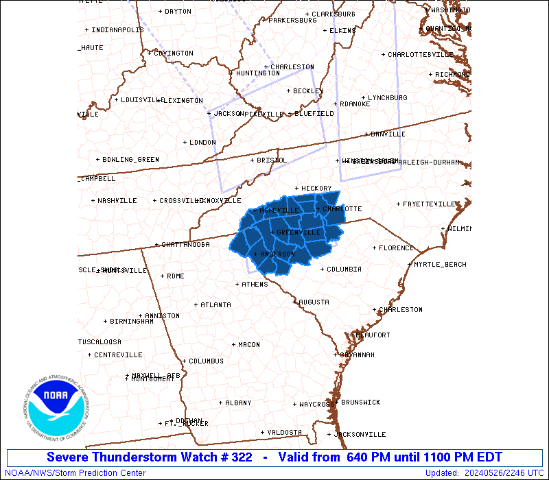
Initial List of Counties in SPC Severe Thunderstorm Watch 322 (WOU)
|
Back to Watch 322
|
 |
   WOUS64 KWNS 262240
   WOU2

   BULLETIN - IMMEDIATE BROADCAST REQUESTED
   SEVERE THUNDERSTORM WATCH OUTLINE UPDATE FOR WS 322
   NWS STORM PREDICTION CENTER NORMAN OK
   640 PM EDT SUN MAY 26 2024

   SEVERE THUNDERSTORM WATCH 322 IS IN EFFECT UNTIL 1100 PM EDT
   FOR THE FOLLOWING LOCATIONS

   NCC025-045-071-089-109-119-149-161-175-179-270300-
   /O.NEW.KWNS.SV.A.0322.240526T2240Z-240527T0300Z/

   NC
   .    NORTH CAROLINA COUNTIES INCLUDED ARE

   CABARRUS             CLEVELAND           GASTON
   HENDERSON            LINCOLN             MECKLENBURG
   POLK                 RUTHERFORD          TRANSYLVANIA
   UNION


   SCC001-007-021-023-039-045-047-057-059-071-073-077-083-087-091-
   270300-
   /O.NEW.KWNS.SV.A.0322.240526T2240Z-240527T0300Z/

   SC
   .    SOUTH CAROLINA COUNTIES INCLUDED ARE

   ABBEVILLE            ANDERSON            CHEROKEE
   CHESTER              FAIRFIELD           GREENVILLE
   GREENWOOD            LANCASTER           LAURENS
   NEWBERRY             OCONEE              PICKENS
   SPARTANBURG          UNION               YORK


   ATTN...WFO...GSP...CAE...
|
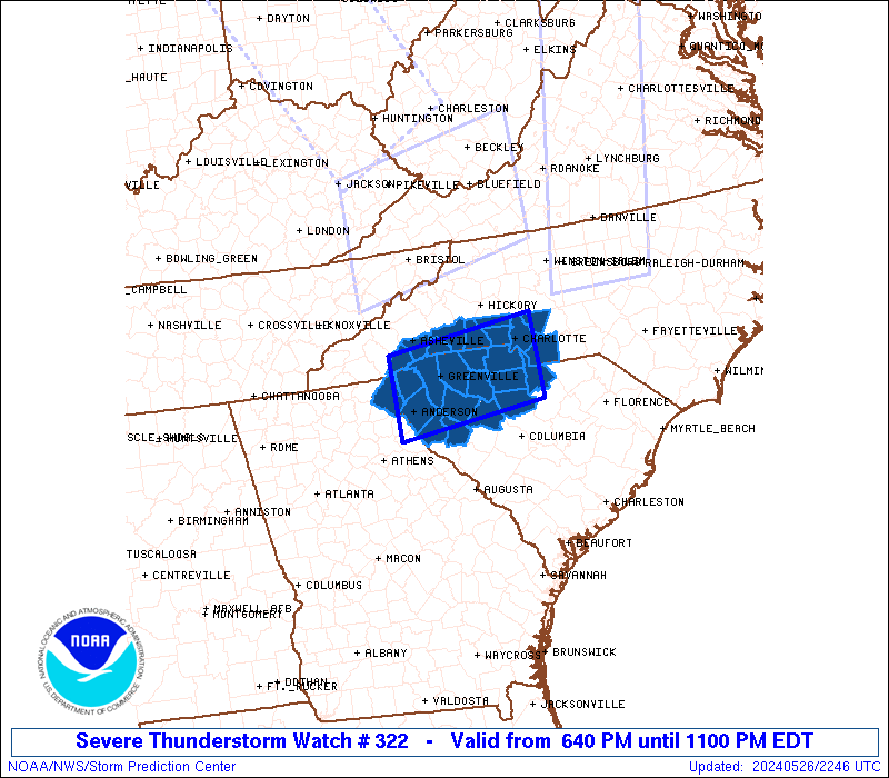
| Aviation Watch (SAW) for WW322 |
|---|
 |
| Note:
The Aviation Watch (SAW) product is an approximation to the watch area.
The actual watch is depicted by the shaded areas. |
   SAW2
   WW 322 SEVERE TSTM NC SC 262240Z - 270300Z
   AXIS..40 STATUTE MILES NORTH AND SOUTH OF LINE..
   20NW AND/ANDERSON SC/ - 25SE CLT/CHARLOTTE NC/
   ..AVIATION COORDS.. 35NM N/S /16E ODF - 21SE CLT/
   HAIL SURFACE AND ALOFT..1.5 INCHES. WIND GUSTS..60 KNOTS.
   MAX TOPS TO 500. MEAN STORM MOTION VECTOR 25030.

   LAT...LON 35288297 35548064 34388064 34138297

   THIS IS AN APPROXIMATION TO THE WATCH AREA.  FOR A
   COMPLETE DEPICTION OF THE WATCH SEE WOUS64 KWNS
   FOR WOU2.
|
|


 @NWSSPC