 Note:
The expiration time in the watch graphic is amended if the watch is
replaced, cancelled or extended.
Note:
Note:
The expiration time in the watch graphic is amended if the watch is
replaced, cancelled or extended.
Note: Click for
Watch Status Reports.
SEL0
URGENT - IMMEDIATE BROADCAST REQUESTED
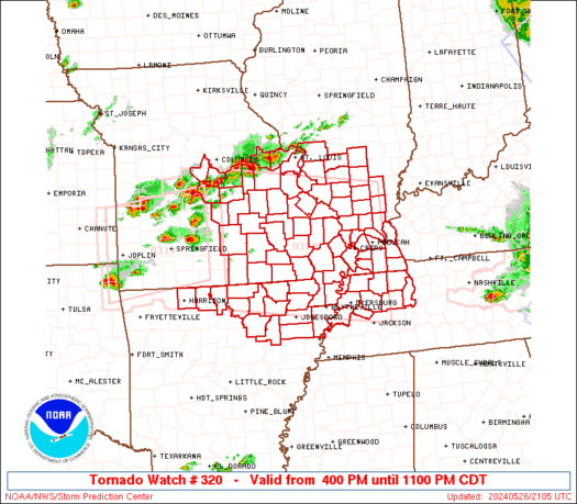
Tornado Watch Number 320
NWS Storm Prediction Center Norman OK
400 PM CDT Sun May 26 2024
The NWS Storm Prediction Center has issued a
* Tornado Watch for portions of
Northern Arkansas
Southern Illinois
Western Kentucky
East-Central and Southeast Missouri
Northwest Tennessee
* Effective this Sunday afternoon and evening from 400 PM until
1100 PM CDT.
...THIS IS A PARTICULARLY DANGEROUS SITUATION...
* Primary threats include...
Several tornadoes and a few intense tornadoes likely
Widespread damaging winds and scattered significant gusts to 75
mph likely
Widespread large hail and scattered very large hail events to 3
inches in diameter likely
SUMMARY...Intense supercell thunderstorms will continue to develop
across the watch area through this evening. Several tornadoes are
likely, some of which are expected to be intense. Very large hail is
also likely, along with the risk for potentially significant
damaging wind gusts.
The tornado watch area is approximately along and 90 statute miles
north and south of a line from 45 miles north northwest of West
Plains MO to 20 miles southeast of Paducah KY. For a complete
depiction of the watch see the associated watch outline update
(WOUS64 KWNS WOU0).
PRECAUTIONARY/PREPAREDNESS ACTIONS...
REMEMBER...A Tornado Watch means conditions are favorable for
tornadoes and severe thunderstorms in and close to the watch
area. Persons in these areas should be on the lookout for
threatening weather conditions and listen for later statements
and possible warnings.
&&
OTHER WATCH INFORMATION...CONTINUE...WW 316...WW 317...WW
318...WW 319...
AVIATION...Tornadoes and a few severe thunderstorms with hail
surface and aloft to 3 inches. Extreme turbulence and surface wind
gusts to 65 knots. A few cumulonimbi with maximum tops to 650. Mean
storm motion vector 28035.
...Bunting

   SEL0

   URGENT - IMMEDIATE BROADCAST REQUESTED
   Tornado Watch Number 320
   NWS Storm Prediction Center Norman OK
   400 PM CDT Sun May 26 2024

   The NWS Storm Prediction Center has issued a

   * Tornado Watch for portions of
     Northern Arkansas
     Southern Illinois
     Western Kentucky
     East-Central and Southeast Missouri
     Northwest Tennessee

   * Effective this Sunday afternoon and evening from 400 PM until
     1100 PM CDT.

   ...THIS IS A PARTICULARLY DANGEROUS SITUATION...

   * Primary threats include...
     Several tornadoes and a few intense tornadoes likely
     Widespread damaging winds and scattered significant gusts to 75
       mph likely
     Widespread large hail and scattered very large hail events to 3
       inches in diameter likely

   SUMMARY...Intense supercell thunderstorms will continue to develop
   across the watch area through this evening. Several tornadoes are
   likely, some of which are expected to be intense. Very large hail is
   also likely, along with the risk for potentially significant
   damaging wind gusts.

   The tornado watch area is approximately along and 90 statute miles
   north and south of a line from 45 miles north northwest of West
   Plains MO to 20 miles southeast of Paducah KY. For a complete
   depiction of the watch see the associated watch outline update
   (WOUS64 KWNS WOU0).

   PRECAUTIONARY/PREPAREDNESS ACTIONS...

   REMEMBER...A Tornado Watch means conditions are favorable for
   tornadoes and severe thunderstorms in and close to the watch
   area. Persons in these areas should be on the lookout for
   threatening weather conditions and listen for later statements
   and possible warnings.

   &&

   OTHER WATCH INFORMATION...CONTINUE...WW 316...WW 317...WW
   318...WW 319...

   AVIATION...Tornadoes and a few severe thunderstorms with hail
   surface and aloft to 3 inches. Extreme turbulence and surface wind
   gusts to 65 knots. A few cumulonimbi with maximum tops to 650. Mean
   storm motion vector 28035.

   ...Bunting
 Note:
The Aviation Watch (SAW) product is an approximation to the watch area.
The actual watch is depicted by the shaded areas.
Note:
The Aviation Watch (SAW) product is an approximation to the watch area.
The actual watch is depicted by the shaded areas.
   SAW0
   WW 320 TORNADO AR IL KY MO TN 262100Z - 270400Z
   AXIS..90 STATUTE MILES NORTH AND SOUTH OF LINE..
   45NNW UNO/WEST PLAINS MO/ - 20SE PAH/PADUCAH KY/
   ..AVIATION COORDS.. 80NM N/S /55E SGF - 64NE DYR/
   HAIL SURFACE AND ALOFT..3 INCHES. WIND GUSTS..65 KNOTS.
   MAX TOPS TO 650. MEAN STORM MOTION VECTOR 28035.

   LAT...LON 38659218 38168851 35568851 36059218

   THIS IS AN APPROXIMATION TO THE WATCH AREA.  FOR A
   COMPLETE DEPICTION OF THE WATCH SEE WOUS64 KWNS
   FOR WOU0.
Watch 320 Status Report Messages:
STATUS REPORT #3 ON WW 320

VALID 270350Z - 270440Z

SEVERE WEATHER THREAT CONTINUES RIGHT OF A LINE FROM 20 W BVX TO
20 S POF TO 25 S CGI TO 10 SSE PAH TO 35 SSW OWB.

..LYONS..05/27/24

ATTN...WFO...LZK...MEG...PAH...LSX...SGF...

&&

STATUS REPORT FOR WT 320

SEVERE WEATHER THREAT CONTINUES FOR THE FOLLOWING AREAS

ARC063-075-270440-

AR
.    ARKANSAS COUNTIES INCLUDED ARE

INDEPENDENCE	     LAWRENCE
$$


KYC035-039-075-083-105-139-157-270440-

KY
.    KENTUCKY COUNTIES INCLUDED ARE

CALLOWAY	     CARLISLE		 FULTON
GRAVES		     HICKMAN		 LIVINGSTON
MARSHALL
$$


MOC133-143-270440-

MO
.    MISSOURI COUNTIES INCLUDED ARE

MISSISSIPPI	     NEW MADRID
$$


THE WATCH STATUS MESSAGE IS FOR GUIDANCE PURPOSES ONLY.  PLEASE
REFER TO WATCH COUNTY NOTIFICATION STATEMENTS FOR OFFICIAL
INFORMATION ON COUNTIES...INDEPENDENT CITIES AND MARINE ZONES
CLEARED FROM SEVERE THUNDERSTORM AND TORNADO WATCHES.
$$

STATUS REPORT #2 ON WW 320

VALID 270115Z - 270240Z

SEVERE WEATHER THREAT CONTINUES RIGHT OF A LINE FROM 35 S TBN TO
45 NE UNO TO 30 NNW CGI TO 5 ENE MVN TO 35 S MTO TO 5 WNW CMI.

..LYONS..05/27/24

ATTN...WFO...LZK...MEG...PAH...LSX...SGF...

&&

STATUS REPORT FOR WT 320

SEVERE WEATHER THREAT CONTINUES FOR THE FOLLOWING AREAS

ARC005-009-021-031-049-055-063-065-067-075-089-093-101-111-121-
129-135-137-270240-

AR
.    ARKANSAS COUNTIES INCLUDED ARE

BAXTER		     BOONE		 CLAY
CRAIGHEAD	     FULTON		 GREENE
INDEPENDENCE	     IZARD		 JACKSON
LAWRENCE	     MARION		 MISSISSIPPI
NEWTON		     POINSETT		 RANDOLPH
SEARCY		     SHARP		 STONE
$$


ILC003-055-065-077-087-127-151-153-165-181-199-270240-

IL
.    ILLINOIS COUNTIES INCLUDED ARE

ALEXANDER	     FRANKLIN		 HAMILTON
JACKSON 	     JOHNSON		 MASSAC
POPE		     PULASKI		 SALINE
UNION		     WILLIAMSON
$$


KYC007-035-039-075-083-105-139-145-157-270240-

KY
.    KENTUCKY COUNTIES INCLUDED ARE

BALLARD 	     CALLOWAY		 CARLISLE
FULTON		     GRAVES		 HICKMAN
LIVINGSTON	     MCCRACKEN		 MARSHALL
$$


MOC017-023-031-035-069-091-133-143-149-155-157-181-201-203-207-
215-223-270240-

MO
.    MISSOURI COUNTIES INCLUDED ARE

BOLLINGER	     BUTLER		 CAPE GIRARDEAU
CARTER		     DUNKLIN		 HOWELL
MISSISSIPPI	     NEW MADRID 	 OREGON
PEMISCOT	     PERRY		 RIPLEY
SCOTT		     SHANNON		 STODDARD
TEXAS		     WAYNE
$$


TNC005-017-033-045-053-079-095-097-131-183-270240-

TN
.    TENNESSEE COUNTIES INCLUDED ARE

BENTON		     CARROLL		 CROCKETT
DYER		     GIBSON		 HENRY
LAKE		     LAUDERDALE 	 OBION
WEAKLEY
$$


THE WATCH STATUS MESSAGE IS FOR GUIDANCE PURPOSES ONLY.  PLEASE
REFER TO WATCH COUNTY NOTIFICATION STATEMENTS FOR OFFICIAL
INFORMATION ON COUNTIES...INDEPENDENT CITIES AND MARINE ZONES
CLEARED FROM SEVERE THUNDERSTORM AND TORNADO WATCHES.
$$

STATUS REPORT #1 ON WW 320

VALID 262200Z - 262340Z

THE SEVERE WEATHER THREAT CONTINUES ACROSS THE ENTIRE WATCH AREA.

..LYONS..05/26/24

ATTN...WFO...LZK...MEG...PAH...LSX...SGF...

&&

STATUS REPORT FOR WT 320

SEVERE WEATHER THREAT CONTINUES FOR THE FOLLOWING AREAS

ARC005-009-021-031-049-055-063-065-067-075-089-093-111-121-135-
262340-

AR
.    ARKANSAS COUNTIES INCLUDED ARE

BAXTER		     BOONE		 CLAY
CRAIGHEAD	     FULTON		 GREENE
INDEPENDENCE	     IZARD		 JACKSON
LAWRENCE	     MARION		 MISSISSIPPI
POINSETT	     RANDOLPH		 SHARP
$$


ILC003-027-055-065-077-081-087-119-121-127-133-145-151-153-157-
163-165-181-189-199-262340-

IL
.    ILLINOIS COUNTIES INCLUDED ARE

ALEXANDER	     CLINTON		 FRANKLIN
HAMILTON	     JACKSON		 JEFFERSON
JOHNSON 	     MADISON		 MARION
MASSAC		     MONROE		 PERRY
POPE		     PULASKI		 RANDOLPH
ST. CLAIR	     SALINE		 UNION
WASHINGTON	     WILLIAMSON
$$


KYC007-035-039-075-083-105-139-145-157-262340-

KY
.    KENTUCKY COUNTIES INCLUDED ARE

BALLARD 	     CALLOWAY		 CARLISLE
FULTON		     GRAVES		 HICKMAN
LIVINGSTON	     MCCRACKEN		 MARSHALL
$$


MOC017-023-031-035-051-055-065-069-071-073-091-093-099-123-125-
131-133-135-143-149-151-155-157-161-169-179-181-183-186-187-189-
201-203-207-215-219-221-223-510-262340-

MO
.    MISSOURI COUNTIES INCLUDED ARE

BOLLINGER	     BUTLER		 CAPE GIRARDEAU
CARTER		     COLE		 CRAWFORD
DENT		     DUNKLIN		 FRANKLIN
GASCONADE	     HOWELL		 IRON
JEFFERSON	     MADISON		 MARIES
MILLER		     MISSISSIPPI	 MONITEAU
NEW MADRID	     OREGON		 OSAGE
PEMISCOT	     PERRY		 PHELPS
PULASKI 	     REYNOLDS		 RIPLEY
ST. CHARLES	     STE. GENEVIEVE	 ST. FRANCOIS
ST. LOUIS	     SCOTT		 SHANNON
STODDARD	     TEXAS		 WARREN
WASHINGTON	     WAYNE


MISSOURI INDEPENDENT CITIES INCLUDED ARE

ST. LOUIS CITY
$$


TNC005-017-033-045-053-079-095-097-131-183-262340-

TN
.    TENNESSEE COUNTIES INCLUDED ARE

BENTON		     CARROLL		 CROCKETT
DYER		     GIBSON		 HENRY
LAKE		     LAUDERDALE 	 OBION
WEAKLEY
$$


THE WATCH STATUS MESSAGE IS FOR GUIDANCE PURPOSES ONLY.  PLEASE
REFER TO WATCH COUNTY NOTIFICATION STATEMENTS FOR OFFICIAL
INFORMATION ON COUNTIES...INDEPENDENT CITIES AND MARINE ZONES
CLEARED FROM SEVERE THUNDERSTORM AND TORNADO WATCHES.
$$
Note:
Click for Complete Product Text.
Tornadoes
Probability of 2 or more tornadoes
|
High (80%)
|
Probability of 1 or more strong (EF2-EF5) tornadoes
|
High (80%)
|
Wind
Probability of 10 or more severe wind events
|
High (80%)
|
Probability of 1 or more wind events > 65 knots
|
High (80%)
|
Hail
Probability of 10 or more severe hail events
|
High (80%)
|
Probability of 1 or more hailstones > 2 inches
|
High (80%)
|
Combined Severe Hail/Wind
Probability of 6 or more combined severe hail/wind events
|
High (>95%)
|
For each watch, probabilities for particular events inside the watch
(listed above in each table) are determined by the issuing forecaster.
The "Low" category contains probability values ranging from less than 2%
to 20% (EF2-EF5 tornadoes), less than 5% to 20% (all other probabilities),
"Moderate" from 30% to 60%, and "High" from 70% to greater than 95%.
High values are bolded and lighter in color to provide awareness of
an increased threat for a particular event.


 @NWSSPC


