 Note:
The expiration time in the watch graphic is amended if the watch is
replaced, cancelled or extended.
Note:
Note:
The expiration time in the watch graphic is amended if the watch is
replaced, cancelled or extended.
Note: Click for
Watch Status Reports.
SEL3
URGENT - IMMEDIATE BROADCAST REQUESTED
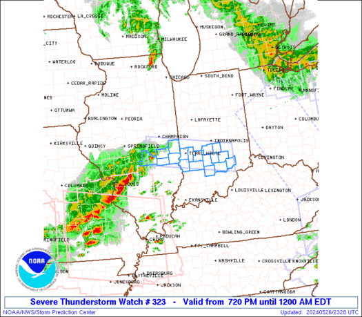
Severe Thunderstorm Watch Number 323
NWS Storm Prediction Center Norman OK
720 PM EDT Sun May 26 2024
The NWS Storm Prediction Center has issued a
* Severe Thunderstorm Watch for portions of
East-Central Illinois
South-Central Indiana
* Effective this Sunday night from 720 PM until Midnight EDT.
* Primary threats include...
Scattered damaging wind gusts to 70 mph likely
Isolated large hail events to 1.5 inches in diameter possible
SUMMARY...A band of thunderstorms is forecast to intensify across
Illinois and move east into portions of central and southern Indiana
during the evening. Damaging gusts will be the primary severe
hazard, although large hail is possible before the evolving
thunderstorm band becomes more extensive into the mid evening.
The severe thunderstorm watch area is approximately along and 30
statute miles north and south of a line from 30 miles west northwest
of Mattoon IL to 60 miles east of Bloomington IN. For a complete
depiction of the watch see the associated watch outline update
(WOUS64 KWNS WOU3).
PRECAUTIONARY/PREPAREDNESS ACTIONS...
REMEMBER...A Severe Thunderstorm Watch means conditions are
favorable for severe thunderstorms in and close to the watch area.
Persons in these areas should be on the lookout for threatening
weather conditions and listen for later statements and possible
warnings. Severe thunderstorms can and occasionally do produce
tornadoes.
&&
OTHER WATCH INFORMATION...CONTINUE...WW 316...WW 317...WW
318...WW 319...WW 320...WW 321...WW 322...
AVIATION...A few severe thunderstorms with hail surface and aloft to
1.5 inches. Extreme turbulence and surface wind gusts to 60 knots. A
few cumulonimbi with maximum tops to 450. Mean storm motion vector
27035.
...Smith

   SEL3

   URGENT - IMMEDIATE BROADCAST REQUESTED
   Severe Thunderstorm Watch Number 323
   NWS Storm Prediction Center Norman OK
   720 PM EDT Sun May 26 2024

   The NWS Storm Prediction Center has issued a

   * Severe Thunderstorm Watch for portions of
     East-Central Illinois
     South-Central Indiana

   * Effective this Sunday night from 720 PM until Midnight EDT.

   * Primary threats include...
     Scattered damaging wind gusts to 70 mph likely
     Isolated large hail events to 1.5 inches in diameter possible

   SUMMARY...A band of thunderstorms is forecast to intensify across
   Illinois and move east into portions of central and southern Indiana
   during the evening.  Damaging gusts will be the primary severe
   hazard, although large hail is possible before the evolving
   thunderstorm band becomes more extensive into the mid evening.

   The severe thunderstorm watch area is approximately along and 30
   statute miles north and south of a line from 30 miles west northwest
   of Mattoon IL to 60 miles east of Bloomington IN. For a complete
   depiction of the watch see the associated watch outline update
   (WOUS64 KWNS WOU3).

   PRECAUTIONARY/PREPAREDNESS ACTIONS...

   REMEMBER...A Severe Thunderstorm Watch means conditions are
   favorable for severe thunderstorms in and close to the watch area.
   Persons in these areas should be on the lookout for threatening
   weather conditions and listen for later statements and possible
   warnings. Severe thunderstorms can and occasionally do produce
   tornadoes.

   &&

   OTHER WATCH INFORMATION...CONTINUE...WW 316...WW 317...WW
   318...WW 319...WW 320...WW 321...WW 322...

   AVIATION...A few severe thunderstorms with hail surface and aloft to
   1.5 inches. Extreme turbulence and surface wind gusts to 60 knots. A
   few cumulonimbi with maximum tops to 450. Mean storm motion vector
   27035.

   ...Smith
 Note:
The Aviation Watch (SAW) product is an approximation to the watch area.
The actual watch is depicted by the shaded areas.
Note:
The Aviation Watch (SAW) product is an approximation to the watch area.
The actual watch is depicted by the shaded areas.
   SAW3
   WW 323 SEVERE TSTM IL IN 262320Z - 270400Z
   AXIS..30 STATUTE MILES NORTH AND SOUTH OF LINE..
   30WNW MTO/MATTOON IL/ - 60E BMG/BLOOMINGTON IN/
   ..AVIATION COORDS.. 25NM N/S /7SSE AXC - 38WNW CVG/
   HAIL SURFACE AND ALOFT..1.5 INCHES. WIND GUSTS..60 KNOTS.
   MAX TOPS TO 450. MEAN STORM MOTION VECTOR 27035.

   LAT...LON 40078880 39588550 38718550 39208880

   THIS IS AN APPROXIMATION TO THE WATCH AREA.  FOR A
   COMPLETE DEPICTION OF THE WATCH SEE WOUS64 KWNS
   FOR WOU3.
Watch 323 Status Report Messages:
STATUS REPORT #4 ON WW 323

VALID 270350Z - 270400Z

SEVERE WEATHER THREAT CONTINUES RIGHT OF A LINE FROM 35 N SDF TO
50 E BMG TO 35 SE IND TO 20 ESE IND TO 5 NNE IND.

WW 323 WILL BE ALLOWED TO EXPIRE AT 270400Z.

..LYONS..05/27/24

ATTN...WFO...ILX...IND...

&&

STATUS REPORT FOR WS 323

SEVERE WEATHER THREAT CONTINUES FOR THE FOLLOWING AREAS

INC079-270400-

IN
.    INDIANA COUNTIES INCLUDED ARE

JENNINGS
$$


THE WATCH STATUS MESSAGE IS FOR GUIDANCE PURPOSES ONLY.  PLEASE
REFER TO WATCH COUNTY NOTIFICATION STATEMENTS FOR OFFICIAL
INFORMATION ON COUNTIES...INDEPENDENT CITIES AND MARINE ZONES
CLEARED FROM SEVERE THUNDERSTORM AND TORNADO WATCHES.
$$

STATUS REPORT #3 ON WW 323

VALID 270305Z - 270440Z

SEVERE WEATHER THREAT CONTINUES RIGHT OF A LINE FROM 25 S BMG TO
25 N HUF.

..LYONS..05/27/24

ATTN...WFO...ILX...IND...

&&

STATUS REPORT FOR WS 323

SEVERE WEATHER THREAT CONTINUES FOR THE FOLLOWING AREAS

INC005-013-071-079-081-093-105-109-119-270440-

IN
.    INDIANA COUNTIES INCLUDED ARE

BARTHOLOMEW	     BROWN		 JACKSON
JENNINGS	     JOHNSON		 LAWRENCE
MONROE		     MORGAN		 OWEN
$$


THE WATCH STATUS MESSAGE IS FOR GUIDANCE PURPOSES ONLY.  PLEASE
REFER TO WATCH COUNTY NOTIFICATION STATEMENTS FOR OFFICIAL
INFORMATION ON COUNTIES...INDEPENDENT CITIES AND MARINE ZONES
CLEARED FROM SEVERE THUNDERSTORM AND TORNADO WATCHES.
$$

STATUS REPORT #2 ON WW 323

VALID 270120Z - 270240Z

SEVERE WEATHER THREAT CONTINUES RIGHT OF A LINE FROM 25 S MTO TO
15 SW DNV.

..LYONS..05/27/24

ATTN...WFO...ILX...IND...

&&

STATUS REPORT FOR WS 323

SEVERE WEATHER THREAT CONTINUES FOR THE FOLLOWING AREAS

ILC023-035-045-270240-

IL
.    ILLINOIS COUNTIES INCLUDED ARE

CLARK		     CUMBERLAND 	 EDGAR
$$


INC005-013-021-055-071-079-081-093-105-109-119-153-167-270240-

IN
.    INDIANA COUNTIES INCLUDED ARE

BARTHOLOMEW	     BROWN		 CLAY
GREENE		     JACKSON		 JENNINGS
JOHNSON 	     LAWRENCE		 MONROE
MORGAN		     OWEN		 SULLIVAN
VIGO
$$


THE WATCH STATUS MESSAGE IS FOR GUIDANCE PURPOSES ONLY.  PLEASE
REFER TO WATCH COUNTY NOTIFICATION STATEMENTS FOR OFFICIAL
INFORMATION ON COUNTIES...INDEPENDENT CITIES AND MARINE ZONES
CLEARED FROM SEVERE THUNDERSTORM AND TORNADO WATCHES.
$$

STATUS REPORT #1 ON WW 323

VALID 270020Z - 270140Z

THE SEVERE WEATHER THREAT CONTINUES ACROSS THE ENTIRE WATCH AREA.

..LYONS..05/27/24

ATTN...WFO...ILX...IND...

&&

STATUS REPORT FOR WS 323

SEVERE WEATHER THREAT CONTINUES FOR THE FOLLOWING AREAS

ILC023-029-035-045-173-270140-

IL
.    ILLINOIS COUNTIES INCLUDED ARE

CLARK		     COLES		 CUMBERLAND
EDGAR		     SHELBY
$$


INC005-013-021-055-071-079-081-093-105-109-119-153-167-270140-

IN
.    INDIANA COUNTIES INCLUDED ARE

BARTHOLOMEW	     BROWN		 CLAY
GREENE		     JACKSON		 JENNINGS
JOHNSON 	     LAWRENCE		 MONROE
MORGAN		     OWEN		 SULLIVAN
VIGO
$$


THE WATCH STATUS MESSAGE IS FOR GUIDANCE PURPOSES ONLY.  PLEASE
REFER TO WATCH COUNTY NOTIFICATION STATEMENTS FOR OFFICIAL
INFORMATION ON COUNTIES...INDEPENDENT CITIES AND MARINE ZONES
CLEARED FROM SEVERE THUNDERSTORM AND TORNADO WATCHES.
$$
Note:
Click for Complete Product Text.
Tornadoes
Probability of 2 or more tornadoes
|
Low (10%)
|
Probability of 1 or more strong (EF2-EF5) tornadoes
|
Low (10%)
|
Wind
Probability of 10 or more severe wind events
|
Mod (60%)
|
Probability of 1 or more wind events > 65 knots
|
Low (20%)
|
Hail
Probability of 10 or more severe hail events
|
Mod (30%)
|
Probability of 1 or more hailstones > 2 inches
|
Low (20%)
|
Combined Severe Hail/Wind
Probability of 6 or more combined severe hail/wind events
|
High (80%)
|
For each watch, probabilities for particular events inside the watch
(listed above in each table) are determined by the issuing forecaster.
The "Low" category contains probability values ranging from less than 2%
to 20% (EF2-EF5 tornadoes), less than 5% to 20% (all other probabilities),
"Moderate" from 30% to 60%, and "High" from 70% to greater than 95%.
High values are bolded and lighter in color to provide awareness of
an increased threat for a particular event.


 @NWSSPC


