Note:
The expiration time in the watch graphic is amended if the watch is
replaced, cancelled or extended.
Note:
Note:
The expiration time in the watch graphic is amended if the watch is
replaced, cancelled or extended.
Note: Click for
Watch Status Reports.
SEL4
URGENT - IMMEDIATE BROADCAST REQUESTED
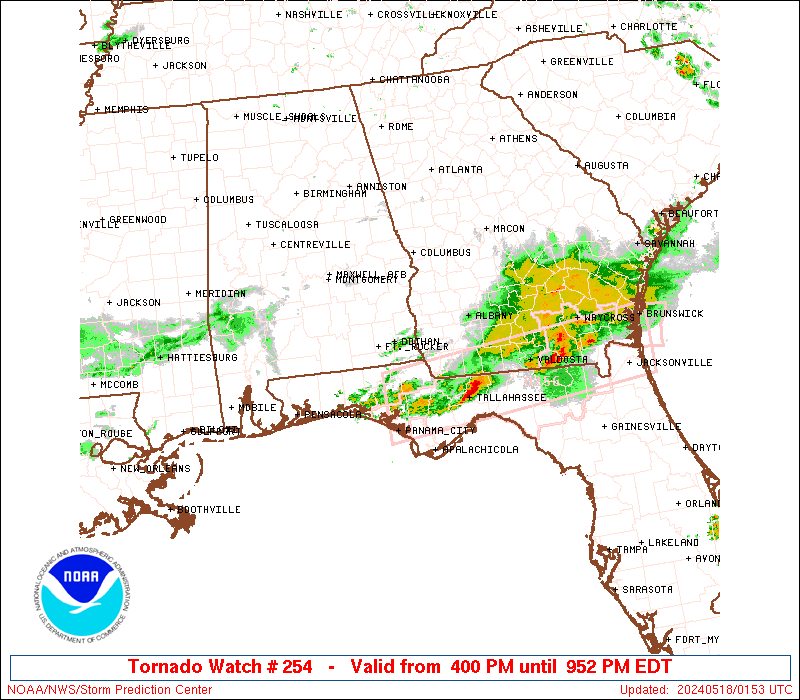
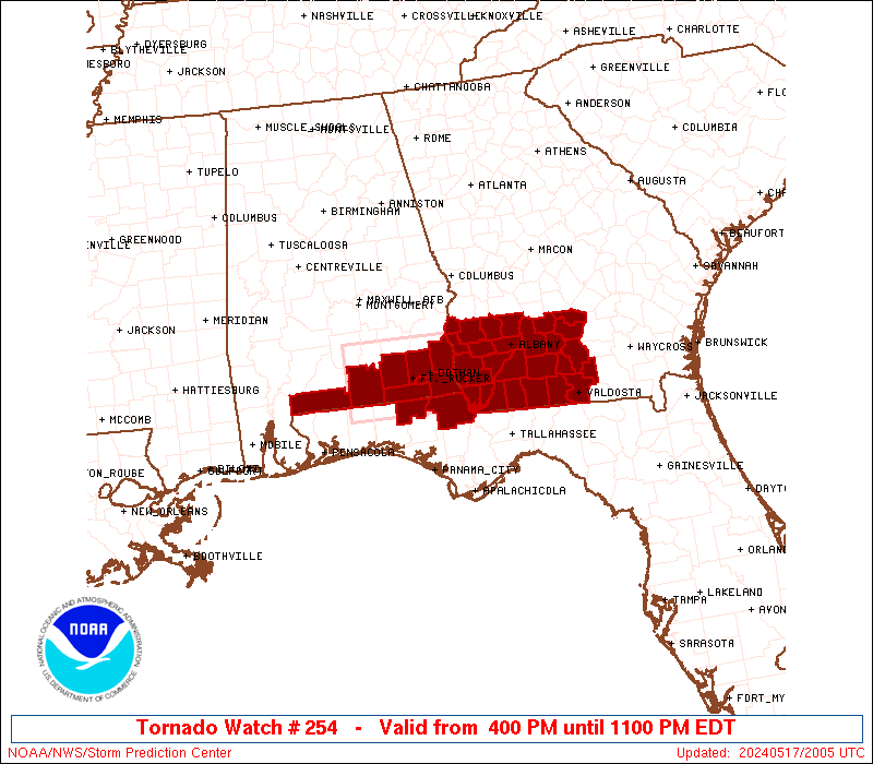
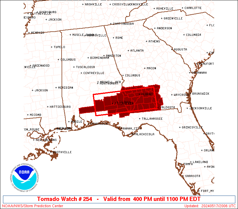
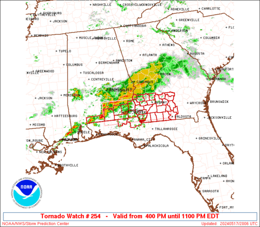
Tornado Watch Number 254
NWS Storm Prediction Center Norman OK
400 PM EDT Fri May 17 2024
The NWS Storm Prediction Center has issued a
* Tornado Watch for portions of
Southeast Alabama
Northern Florida Panhandle
Southwest Georgia
* Effective this Friday afternoon and evening from 400 PM until
1100 PM EDT.
* Primary threats include...
A few tornadoes possible
Scattered large hail likely with isolated very large hail events
to 2 inches in diameter possible
Scattered damaging wind gusts to 70 mph likely
SUMMARY...Thunderstorms will intensify this afternoon along a
surface boundary and track eastward across the watch area. Locally
severe storms are expected, with damaging winds, hail, and a few
tornadoes possible.
The tornado watch area is approximately along and 35 statute miles
north and south of a line from 75 miles west of Dothan AL to 30
miles east northeast of Moultrie GA. For a complete depiction of the
watch see the associated watch outline update (WOUS64 KWNS WOU4).
PRECAUTIONARY/PREPAREDNESS ACTIONS...
REMEMBER...A Tornado Watch means conditions are favorable for
tornadoes and severe thunderstorms in and close to the watch
area. Persons in these areas should be on the lookout for
threatening weather conditions and listen for later statements
and possible warnings.
&&
OTHER WATCH INFORMATION...CONTINUE...WW 253...
AVIATION...Tornadoes and a few severe thunderstorms with hail
surface and aloft to 2 inches. Extreme turbulence and surface wind
gusts to 60 knots. A few cumulonimbi with maximum tops to 500. Mean
storm motion vector 27030.
...Hart
   SEL4

   URGENT - IMMEDIATE BROADCAST REQUESTED
   Tornado Watch Number 254
   NWS Storm Prediction Center Norman OK
   400 PM EDT Fri May 17 2024

   The NWS Storm Prediction Center has issued a

   * Tornado Watch for portions of
     Southeast Alabama
     Northern Florida Panhandle
     Southwest Georgia

   * Effective this Friday afternoon and evening from 400 PM until
     1100 PM EDT.

   * Primary threats include...
     A few tornadoes possible
     Scattered large hail likely with isolated very large hail events
       to 2 inches in diameter possible
     Scattered damaging wind gusts to 70 mph likely

   SUMMARY...Thunderstorms will intensify this afternoon along a
   surface boundary and track eastward across the watch area.  Locally
   severe storms are expected, with damaging winds, hail, and a few
   tornadoes possible.

   The tornado watch area is approximately along and 35 statute miles
   north and south of a line from 75 miles west of Dothan AL to 30
   miles east northeast of Moultrie GA. For a complete depiction of the
   watch see the associated watch outline update (WOUS64 KWNS WOU4).

   PRECAUTIONARY/PREPAREDNESS ACTIONS...

   REMEMBER...A Tornado Watch means conditions are favorable for
   tornadoes and severe thunderstorms in and close to the watch
   area. Persons in these areas should be on the lookout for
   threatening weather conditions and listen for later statements
   and possible warnings.

   &&

   OTHER WATCH INFORMATION...CONTINUE...WW 253...

   AVIATION...Tornadoes and a few severe thunderstorms with hail
   surface and aloft to 2 inches. Extreme turbulence and surface wind
   gusts to 60 knots. A few cumulonimbi with maximum tops to 500. Mean
   storm motion vector 27030.

   ...Hart
 Note:
The Aviation Watch (SAW) product is an approximation to the watch area.
The actual watch is depicted by the shaded areas.
Note:
The Aviation Watch (SAW) product is an approximation to the watch area.
The actual watch is depicted by the shaded areas.
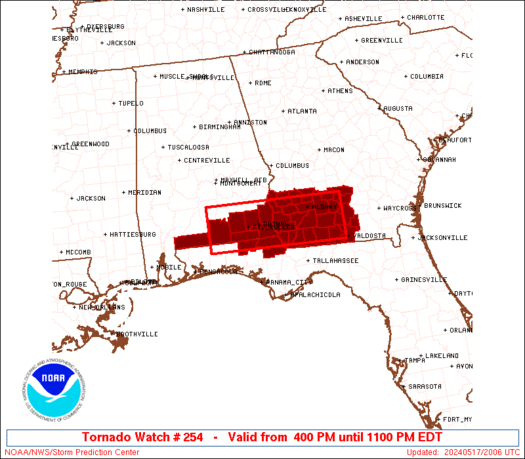
   SAW4
   WW 254 TORNADO AL FL GA 172000Z - 180300Z
   AXIS..35 STATUTE MILES NORTH AND SOUTH OF LINE..
   75W DHN/DOTHAN AL/ - 30ENE MGR/MOULTRIE GA/
   ..AVIATION COORDS.. 30NM N/S /29N CEW - 46WSW AMG/
   HAIL SURFACE AND ALOFT..2 INCHES. WIND GUSTS..60 KNOTS.
   MAX TOPS TO 500. MEAN STORM MOTION VECTOR 27030.

   LAT...LON 31828672 31758333 30748333 30818672

   THIS IS AN APPROXIMATION TO THE WATCH AREA.  FOR A
   COMPLETE DEPICTION OF THE WATCH SEE WOUS64 KWNS
   FOR WOU4.
Watch 254 Status Report Messages:
STATUS REPORT #4 ON WW 254
VALID 180025Z - 180140Z
SEVERE WEATHER THREAT CONTINUES RIGHT OF A LINE FROM 20 SSE CEW
TO 10 E CEW TO 15 SSE DHN TO 20 NNE MGR TO 30 S VDI.
..DEAN..05/18/24
ATTN...WFO...TAE...MOB...
&&
STATUS REPORT FOR WT 254
SEVERE WEATHER THREAT CONTINUES FOR THE FOLLOWING AREAS
FLC059-063-131-133-180140-
FL
. FLORIDA COUNTIES INCLUDED ARE
HOLMES JACKSON WALTON
WASHINGTON
$$
GAC019-027-071-075-087-131-173-185-253-275-180140-
GA
. GEORGIA COUNTIES INCLUDED ARE
BERRIEN BROOKS COLQUITT
COOK DECATUR GRADY
LANIER LOWNDES SEMINOLE
THOMAS
$$
THE WATCH STATUS MESSAGE IS FOR GUIDANCE PURPOSES ONLY. PLEASE
REFER TO WATCH COUNTY NOTIFICATION STATEMENTS FOR OFFICIAL
INFORMATION ON COUNTIES...INDEPENDENT CITIES AND MARINE ZONES
CLEARED FROM SEVERE THUNDERSTORM AND TORNADO WATCHES.
$$
STATUS REPORT #3 ON WW 254
VALID 172340Z - 180040Z
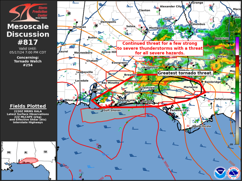
THE SEVERE WEATHER THREAT CONTINUES ACROSS THE ENTIRE WATCH AREA.
FOR ADDITIONAL INFORMATION SEE MESOSCALE DISCUSSION 817
..DEAN..05/17/24
ATTN...WFO...TAE...MOB...
&&
STATUS REPORT FOR WT 254
SEVERE WEATHER THREAT CONTINUES FOR THE FOLLOWING AREAS
ALC003-031-039-045-053-061-067-069-180040-
AL
. ALABAMA COUNTIES INCLUDED ARE
BALDWIN COFFEE COVINGTON
DALE ESCAMBIA GENEVA
HENRY HOUSTON
$$
FLC033-059-063-091-113-131-133-180040-
FL
. FLORIDA COUNTIES INCLUDED ARE
ESCAMBIA HOLMES JACKSON
OKALOOSA SANTA ROSA WALTON
WASHINGTON
$$
GAC007-017-019-027-037-061-071-075-087-095-099-131-155-173-177-
185-201-205-239-243-253-273-275-277-287-321-180040-
GA
. GEORGIA COUNTIES INCLUDED ARE
BAKER BEN HILL BERRIEN
BROOKS CALHOUN CLAY
COLQUITT COOK DECATUR
DOUGHERTY EARLY GRADY
IRWIN LANIER LEE
LOWNDES MILLER MITCHELL
QUITMAN RANDOLPH SEMINOLE
TERRELL THOMAS TIFT
TURNER WORTH
$$
GMZ634-635-636-650-655-180040-
CW
. ADJACENT COASTAL WATERS INCLUDED ARE
GMZ634
GMZ635
GMZ636
GMZ650
GMZ655
$$
THE WATCH STATUS MESSAGE IS FOR GUIDANCE PURPOSES ONLY. PLEASE
REFER TO WATCH COUNTY NOTIFICATION STATEMENTS FOR OFFICIAL
INFORMATION ON COUNTIES...INDEPENDENT CITIES AND MARINE ZONES
CLEARED FROM SEVERE THUNDERSTORM AND TORNADO WATCHES.
$$
STATUS REPORT #2 ON WW 254
VALID 172230Z - 172340Z
THE SEVERE WEATHER THREAT CONTINUES ACROSS THE ENTIRE WATCH AREA.
..DEAN..05/17/24
ATTN...WFO...TAE...MOB...
&&
STATUS REPORT FOR WT 254
SEVERE WEATHER THREAT CONTINUES FOR THE FOLLOWING AREAS
ALC003-031-039-045-053-061-067-069-172340-
AL
. ALABAMA COUNTIES INCLUDED ARE
BALDWIN COFFEE COVINGTON
DALE ESCAMBIA GENEVA
HENRY HOUSTON
$$
FLC033-059-063-091-113-131-133-172340-
FL
. FLORIDA COUNTIES INCLUDED ARE
ESCAMBIA HOLMES JACKSON
OKALOOSA SANTA ROSA WALTON
WASHINGTON
$$
GAC007-017-019-027-037-061-071-075-087-095-099-131-155-173-177-
185-201-205-239-243-253-273-275-277-287-321-172340-
GA
. GEORGIA COUNTIES INCLUDED ARE
BAKER BEN HILL BERRIEN
BROOKS CALHOUN CLAY
COLQUITT COOK DECATUR
DOUGHERTY EARLY GRADY
IRWIN LANIER LEE
LOWNDES MILLER MITCHELL
QUITMAN RANDOLPH SEMINOLE
TERRELL THOMAS TIFT
TURNER WORTH
$$
GMZ634-635-636-650-655-172340-
CW
. ADJACENT COASTAL WATERS INCLUDED ARE
GMZ634
GMZ635
GMZ636
GMZ650
GMZ655
$$
THE WATCH STATUS MESSAGE IS FOR GUIDANCE PURPOSES ONLY. PLEASE
REFER TO WATCH COUNTY NOTIFICATION STATEMENTS FOR OFFICIAL
INFORMATION ON COUNTIES...INDEPENDENT CITIES AND MARINE ZONES
CLEARED FROM SEVERE THUNDERSTORM AND TORNADO WATCHES.
$$
STATUS REPORT #1 ON WW 254
VALID 172115Z - 172240Z
THE SEVERE WEATHER THREAT CONTINUES ACROSS THE ENTIRE WATCH AREA.
..DEAN..05/17/24
ATTN...WFO...TAE...MOB...
&&
STATUS REPORT FOR WT 254
SEVERE WEATHER THREAT CONTINUES FOR THE FOLLOWING AREAS
ALC003-031-039-045-053-061-067-069-172240-
AL
. ALABAMA COUNTIES INCLUDED ARE
BALDWIN COFFEE COVINGTON
DALE ESCAMBIA GENEVA
HENRY HOUSTON
$$
FLC033-059-063-091-113-131-133-172240-
FL
. FLORIDA COUNTIES INCLUDED ARE
ESCAMBIA HOLMES JACKSON
OKALOOSA SANTA ROSA WALTON
WASHINGTON
$$
GAC007-017-019-027-037-061-071-075-087-095-099-131-155-173-177-
185-201-205-239-243-253-273-275-277-287-321-172240-
GA
. GEORGIA COUNTIES INCLUDED ARE
BAKER BEN HILL BERRIEN
BROOKS CALHOUN CLAY
COLQUITT COOK DECATUR
DOUGHERTY EARLY GRADY
IRWIN LANIER LEE
LOWNDES MILLER MITCHELL
QUITMAN RANDOLPH SEMINOLE
TERRELL THOMAS TIFT
TURNER WORTH
$$
GMZ634-635-636-650-655-172240-
CW
. ADJACENT COASTAL WATERS INCLUDED ARE
GMZ634
GMZ635
GMZ636
GMZ650
GMZ655
$$
THE WATCH STATUS MESSAGE IS FOR GUIDANCE PURPOSES ONLY. PLEASE
REFER TO WATCH COUNTY NOTIFICATION STATEMENTS FOR OFFICIAL
INFORMATION ON COUNTIES...INDEPENDENT CITIES AND MARINE ZONES
CLEARED FROM SEVERE THUNDERSTORM AND TORNADO WATCHES.
$$
Note:
Click for Complete Product Text.
Tornadoes
Probability of 2 or more tornadoes
|
Mod (50%)
|
Probability of 1 or more strong (EF2-EF5) tornadoes
|
Low (20%)
|
Wind
Probability of 10 or more severe wind events
|
Mod (60%)
|
Probability of 1 or more wind events > 65 knots
|
Low (20%)
|
Hail
Probability of 10 or more severe hail events
|
Mod (60%)
|
Probability of 1 or more hailstones > 2 inches
|
Mod (30%)
|
Combined Severe Hail/Wind
Probability of 6 or more combined severe hail/wind events
|
High (>95%)
|
For each watch, probabilities for particular events inside the watch
(listed above in each table) are determined by the issuing forecaster.
The "Low" category contains probability values ranging from less than 2%
to 20% (EF2-EF5 tornadoes), less than 5% to 20% (all other probabilities),
"Moderate" from 30% to 60%, and "High" from 70% to greater than 95%.
High values are bolded and lighter in color to provide awareness of
an increased threat for a particular event.


 @NWSSPC