|
| Mesoscale Discussion 817 |
|
< Previous MD Next MD >
|
|
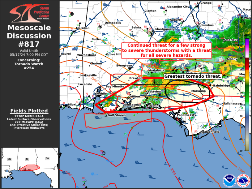
   Mesoscale Discussion 0817
   NWS Storm Prediction Center Norman OK
   0532 PM CDT Fri May 17 2024

   Areas affected...Southern Alabama and the Florida Peninsula

   Concerning...Tornado Watch 254...

   Valid 172232Z - 180000Z

   The severe weather threat for Tornado Watch 254 continues.

   SUMMARY...A few severe thunderstorms are expected to persist through
   the evening with a threat for all severe hazards.

   DISCUSSION...A cluster of storms with embedded supercell structures
   continues to move east along the Alabama/Florida border. The EVX VWP
   shows around 300 m2/s2 of 0-1 km SRH with a 35 to 40 knot low-level
   jet. This strengthening low-level flow is also resulting in
   additional convection developing off the Gulf (which can be seen
   from Okaloosa to Washington counties around 2230Z. This will likely
   continue to support a messy storm mode which, combined with very
   weak low-level lapse rates (per 18Z LIX VWP), are the primary
   limiting factor to a greater tornado/hail threat. However, given the
   strong shear present, a tornado threat will continue through the
   evening, particularly with the lead cell moving through eastern
   Holmes county at 2230Z.

   ..Bentley.. 05/17/2024

   ...Please see www.spc.noaa.gov for graphic product...

   ATTN...WFO...TAE...MOB...

   LAT...LON   30458804 31158670 31178538 30958470 30678454 30468513
               30318596 30288684 30278776 30458804
|
|
Top/All Mesoscale Discussions/Forecast Products/Home
|
|


 @NWSSPC