 Note:
The expiration time in the watch graphic is amended if the watch is
replaced, cancelled or extended.
Note:
Note:
The expiration time in the watch graphic is amended if the watch is
replaced, cancelled or extended.
Note: Click for
Watch Status Reports.
SEL3
URGENT - IMMEDIATE BROADCAST REQUESTED
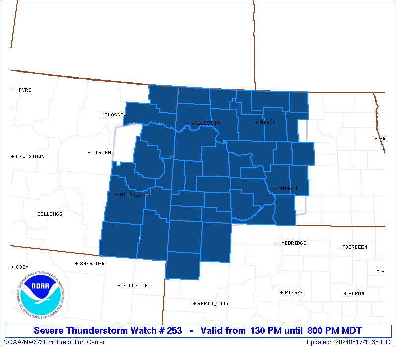
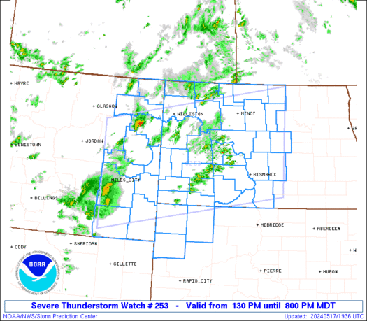
Severe Thunderstorm Watch Number 253
NWS Storm Prediction Center Norman OK
130 PM MDT Fri May 17 2024
The NWS Storm Prediction Center has issued a
* Severe Thunderstorm Watch for portions of
Eastern Montana
Western and Central North Dakota
Northwest South Dakota
* Effective this Friday afternoon and evening from 130 PM until
800 PM MDT.
* Primary threats include...
Scattered damaging winds likely with isolated significant gusts
to 75 mph possible
Isolated large hail events to 1.5 inches in diameter possible
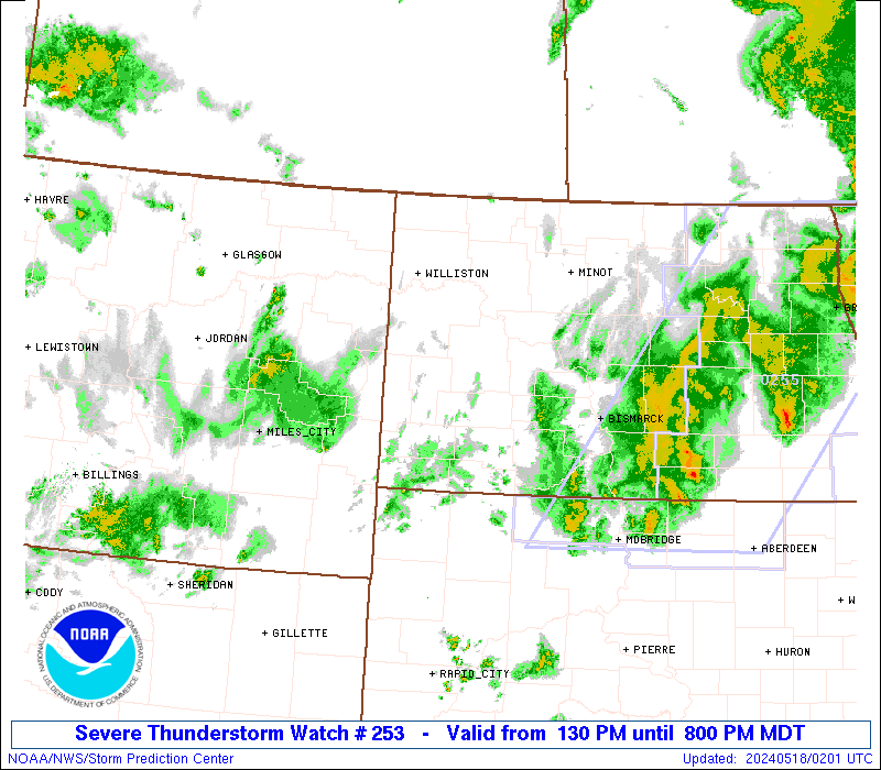
SUMMARY...Scattered thunderstorms will develop and spread across the
watch area through the afternoon and early evening. The strongest
cells will pose a risk of locally damaging wind gusts.
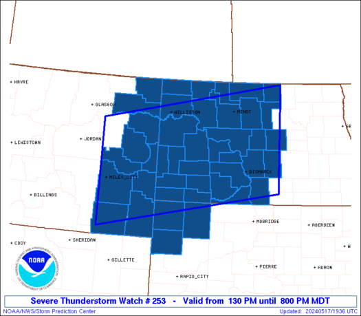
The severe thunderstorm watch area is approximately along and 95
statute miles north and south of a line from 15 miles northwest of
Miles City MT to 80 miles northeast of Bismarck ND. For a complete
depiction of the watch see the associated watch outline update
(WOUS64 KWNS WOU3).
PRECAUTIONARY/PREPAREDNESS ACTIONS...
REMEMBER...A Severe Thunderstorm Watch means conditions are
favorable for severe thunderstorms in and close to the watch area.
Persons in these areas should be on the lookout for threatening
weather conditions and listen for later statements and possible
warnings. Severe thunderstorms can and occasionally do produce
tornadoes.
&&
AVIATION...A few severe thunderstorms with hail surface and aloft to
1.5 inches. Extreme turbulence and surface wind gusts to 65 knots. A
few cumulonimbi with maximum tops to 450. Mean storm motion vector
27035.
...Hart
 Note:
The Aviation Watch (SAW) product is an approximation to the watch area.
The actual watch is depicted by the shaded areas.
Note:
The Aviation Watch (SAW) product is an approximation to the watch area.
The actual watch is depicted by the shaded areas.
   SAW3
   WW 253 SEVERE TSTM MT ND SD 171930Z - 180200Z
   AXIS..95 STATUTE MILES NORTH AND SOUTH OF LINE..
   15NW MLS/MILES CITY MT/ - 80NE BIS/BISMARCK ND/
   ..AVIATION COORDS.. 85NM N/S /14NNW MLS - 68NE BIS/
   HAIL SURFACE AND ALOFT..1.5 INCHES. WIND GUSTS..65 KNOTS.
   MAX TOPS TO 450. MEAN STORM MOTION VECTOR 27035.

   LAT...LON 47960610 48979954 46229954 45210610

   THIS IS AN APPROXIMATION TO THE WATCH AREA.  FOR A
   COMPLETE DEPICTION OF THE WATCH SEE WOUS64 KWNS
   FOR WOU3.
Watch 253 Status Report Messages:
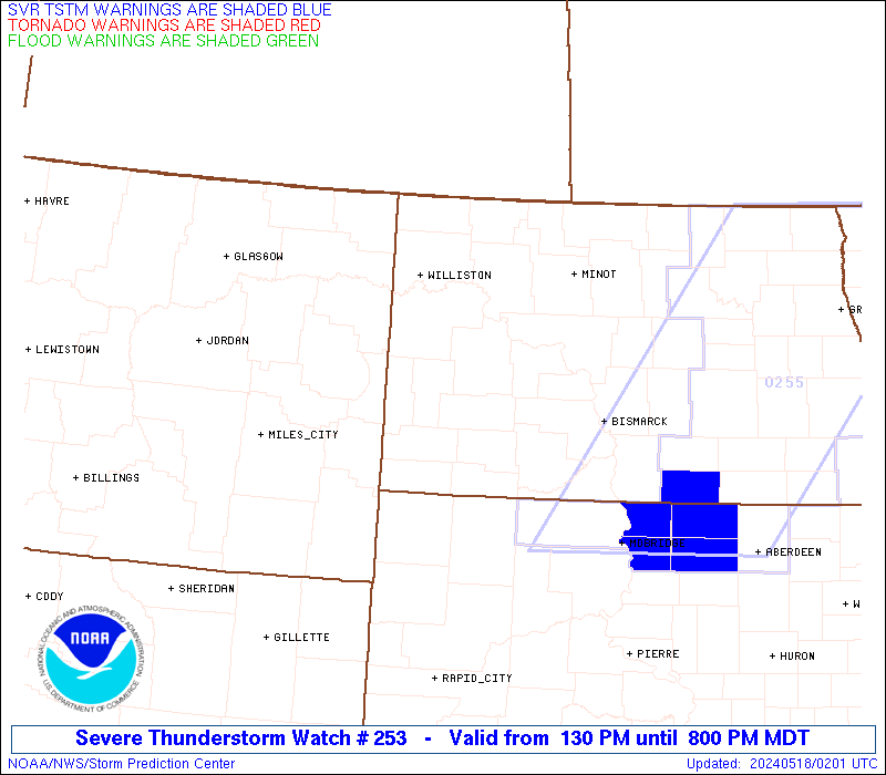
STATUS REPORT #5 ON WW 253

VALID 180130Z - 180240Z

SEVERE WEATHER THREAT CONTINUES RIGHT OF A LINE FROM 40 N MBG TO
50 NW JMS.

..KERR..05/18/24

ATTN...WFO...BYZ...GGW...BIS...UNR...

&&

STATUS REPORT FOR WS 253

SEVERE WEATHER THREAT CONTINUES FOR THE FOLLOWING AREAS

NDC029-043-180240-

ND
.    NORTH DAKOTA COUNTIES INCLUDED ARE

EMMONS		     KIDDER
$$


THE WATCH STATUS MESSAGE IS FOR GUIDANCE PURPOSES ONLY.  PLEASE
REFER TO WATCH COUNTY NOTIFICATION STATEMENTS FOR OFFICIAL
INFORMATION ON COUNTIES...INDEPENDENT CITIES AND MARINE ZONES
CLEARED FROM SEVERE THUNDERSTORM AND TORNADO WATCHES.
$$

STATUS REPORT #4 ON WW 253

VALID 180025Z - 180140Z

SEVERE WEATHER THREAT CONTINUES RIGHT OF A LINE FROM 45 ENE GCC
TO 30 WNW Y22 TO 45 SSW DVL.

..DEAN..05/18/24

ATTN...WFO...BYZ...GGW...BIS...UNR...

&&

STATUS REPORT FOR WS 253

SEVERE WEATHER THREAT CONTINUES FOR THE FOLLOWING AREAS

NDC029-043-085-180140-

ND
.    NORTH DAKOTA COUNTIES INCLUDED ARE

EMMONS		     KIDDER		 SIOUX
$$


SDC019-063-105-180140-

SD
.    SOUTH DAKOTA COUNTIES INCLUDED ARE

BUTTE		     HARDING		 PERKINS
$$


THE WATCH STATUS MESSAGE IS FOR GUIDANCE PURPOSES ONLY.  PLEASE
REFER TO WATCH COUNTY NOTIFICATION STATEMENTS FOR OFFICIAL
INFORMATION ON COUNTIES...INDEPENDENT CITIES AND MARINE ZONES
CLEARED FROM SEVERE THUNDERSTORM AND TORNADO WATCHES.
$$

STATUS REPORT #3 ON WW 253

VALID 172335Z - 180040Z

SEVERE WEATHER THREAT CONTINUES RIGHT OF A LINE FROM 40 ENE GCC
TO 35 WNW Y22 TO 15 WNW DIK TO 25 W MLS.

FOR ADDITIONAL INFORMATION SEE MESOSCALE DISCUSSION 816

..DEAN..05/17/24

ATTN...WFO...BYZ...GGW...BIS...UNR...

&&

STATUS REPORT FOR WS 253

SEVERE WEATHER THREAT CONTINUES FOR THE FOLLOWING AREAS

MTC021-079-083-085-091-109-180040-

MT
.    MONTANA COUNTIES INCLUDED ARE

DAWSON		     PRAIRIE		 RICHLAND
ROOSEVELT	     SHERIDAN		 WIBAUX
$$


NDC001-007-009-015-025-029-033-037-041-043-049-053-055-057-059-
065-069-079-083-085-089-103-180040-

ND
.    NORTH DAKOTA COUNTIES INCLUDED ARE

ADAMS		     BILLINGS		 BOTTINEAU
BURLEIGH	     DUNN		 EMMONS
GOLDEN VALLEY	     GRANT		 HETTINGER
KIDDER		     MCHENRY		 MCKENZIE
MCLEAN		     MERCER		 MORTON
OLIVER		     PIERCE		 ROLETTE
SHERIDAN	     SIOUX		 STARK
WELLS
$$


SDC019-063-105-180040-

SD
.    SOUTH DAKOTA COUNTIES INCLUDED ARE

BUTTE		     HARDING		 PERKINS
$$


THE WATCH STATUS MESSAGE IS FOR GUIDANCE PURPOSES ONLY.  PLEASE
REFER TO WATCH COUNTY NOTIFICATION STATEMENTS FOR OFFICIAL
INFORMATION ON COUNTIES...INDEPENDENT CITIES AND MARINE ZONES
CLEARED FROM SEVERE THUNDERSTORM AND TORNADO WATCHES.
$$

STATUS REPORT #2 ON WW 253

VALID 172225Z - 172340Z

SEVERE WEATHER THREAT CONTINUES RIGHT OF A LINE FROM 35 NNE GCC
TO 15 NNE 2WX TO 5 NW BHK TO 35 WSW MLS.

FOR ADDITIONAL INFORMATION SEE MESOSCALE DISCUSSION 816

..DEAN..05/17/24

ATTN...WFO...BYZ...GGW...BIS...UNR...

&&

STATUS REPORT FOR WS 253

SEVERE WEATHER THREAT CONTINUES FOR THE FOLLOWING AREAS

MTC021-079-083-085-091-109-172340-

MT
.    MONTANA COUNTIES INCLUDED ARE

DAWSON		     PRAIRIE		 RICHLAND
ROOSEVELT	     SHERIDAN		 WIBAUX
$$


NDC001-007-009-011-013-015-023-025-029-033-037-041-043-049-053-
055-057-059-061-065-069-075-079-083-085-087-089-101-103-105-
172340-

ND
.    NORTH DAKOTA COUNTIES INCLUDED ARE

ADAMS		     BILLINGS		 BOTTINEAU
BOWMAN		     BURKE		 BURLEIGH
DIVIDE		     DUNN		 EMMONS
GOLDEN VALLEY	     GRANT		 HETTINGER
KIDDER		     MCHENRY		 MCKENZIE
MCLEAN		     MERCER		 MORTON
MOUNTRAIL	     OLIVER		 PIERCE
RENVILLE	     ROLETTE		 SHERIDAN
SIOUX		     SLOPE		 STARK
WARD		     WELLS		 WILLIAMS
$$


SDC019-063-105-172340-

SD
.    SOUTH DAKOTA COUNTIES INCLUDED ARE

BUTTE		     HARDING		 PERKINS
$$


THE WATCH STATUS MESSAGE IS FOR GUIDANCE PURPOSES ONLY.  PLEASE
REFER TO WATCH COUNTY NOTIFICATION STATEMENTS FOR OFFICIAL
INFORMATION ON COUNTIES...INDEPENDENT CITIES AND MARINE ZONES
CLEARED FROM SEVERE THUNDERSTORM AND TORNADO WATCHES.
$$

STATUS REPORT #1 ON WW 253

VALID 172115Z - 172240Z

THE SEVERE WEATHER THREAT CONTINUES ACROSS THE ENTIRE WATCH AREA.

..DEAN..05/17/24

ATTN...WFO...BYZ...GGW...BIS...UNR...

&&

STATUS REPORT FOR WS 253

SEVERE WEATHER THREAT CONTINUES FOR THE FOLLOWING AREAS

MTC011-017-021-025-075-079-083-085-091-109-172240-

MT
.    MONTANA COUNTIES INCLUDED ARE

CARTER		     CUSTER		 DAWSON
FALLON		     POWDER RIVER	 PRAIRIE
RICHLAND	     ROOSEVELT		 SHERIDAN
WIBAUX
$$


NDC001-007-009-011-013-015-023-025-029-033-037-041-043-049-053-
055-057-059-061-065-069-075-079-083-085-087-089-101-103-105-
172240-

ND
.    NORTH DAKOTA COUNTIES INCLUDED ARE

ADAMS		     BILLINGS		 BOTTINEAU
BOWMAN		     BURKE		 BURLEIGH
DIVIDE		     DUNN		 EMMONS
GOLDEN VALLEY	     GRANT		 HETTINGER
KIDDER		     MCHENRY		 MCKENZIE
MCLEAN		     MERCER		 MORTON
MOUNTRAIL	     OLIVER		 PIERCE
RENVILLE	     ROLETTE		 SHERIDAN
SIOUX		     SLOPE		 STARK
WARD		     WELLS		 WILLIAMS
$$


SDC019-063-105-172240-

SD
.    SOUTH DAKOTA COUNTIES INCLUDED ARE

BUTTE		     HARDING		 PERKINS
$$


THE WATCH STATUS MESSAGE IS FOR GUIDANCE PURPOSES ONLY.  PLEASE
REFER TO WATCH COUNTY NOTIFICATION STATEMENTS FOR OFFICIAL
INFORMATION ON COUNTIES...INDEPENDENT CITIES AND MARINE ZONES
CLEARED FROM SEVERE THUNDERSTORM AND TORNADO WATCHES.
$$
Note:
Click for Complete Product Text.
Tornadoes
Probability of 2 or more tornadoes
|
Low (<5%)
|
Probability of 1 or more strong (EF2-EF5) tornadoes
|
Low (<2%)
|
Wind
Probability of 10 or more severe wind events
|
High (70%)
|
Probability of 1 or more wind events > 65 knots
|
Mod (30%)
|
Hail
Probability of 10 or more severe hail events
|
Low (20%)
|
Probability of 1 or more hailstones > 2 inches
|
Low (10%)
|
Combined Severe Hail/Wind
Probability of 6 or more combined severe hail/wind events
|
High (90%)
|
For each watch, probabilities for particular events inside the watch
(listed above in each table) are determined by the issuing forecaster.
The "Low" category contains probability values ranging from less than 2%
to 20% (EF2-EF5 tornadoes), less than 5% to 20% (all other probabilities),
"Moderate" from 30% to 60%, and "High" from 70% to greater than 95%.
High values are bolded and lighter in color to provide awareness of
an increased threat for a particular event.


 @NWSSPC