|
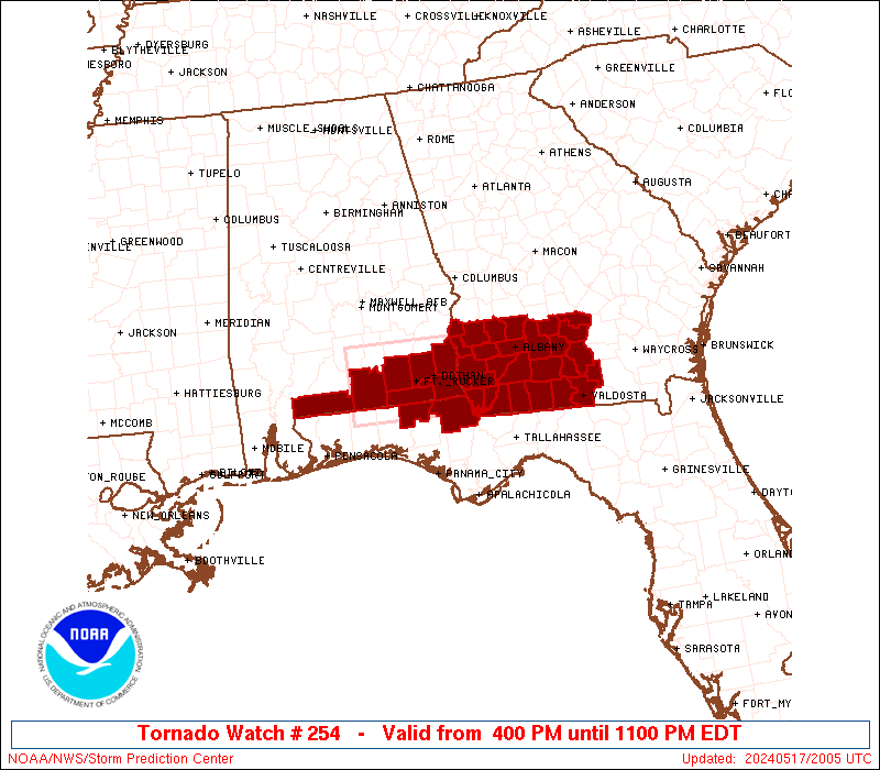
Initial List of Counties in SPC Tornado Watch 254 (WOU)
|
Back to Watch 254
|
 |
   WOUS64 KWNS 171958
   WOU4

   BULLETIN - IMMEDIATE BROADCAST REQUESTED
   TORNADO WATCH OUTLINE UPDATE FOR WT 254
   NWS STORM PREDICTION CENTER NORMAN OK
   400 PM EDT FRI MAY 17 2024

   TORNADO WATCH 254 IS IN EFFECT UNTIL 1100 PM EDT FOR THE
    FOLLOWING LOCATIONS

   ALC031-039-045-053-061-067-069-180300-
   /O.NEW.KWNS.TO.A.0254.240517T2000Z-240518T0300Z/

   AL
   .    ALABAMA COUNTIES INCLUDED ARE

   COFFEE               COVINGTON           DALE
   ESCAMBIA             GENEVA              HENRY
   HOUSTON


   FLC059-063-180300-
   /O.NEW.KWNS.TO.A.0254.240517T2000Z-240518T0300Z/

   FL
   .    FLORIDA COUNTIES INCLUDED ARE

   HOLMES               JACKSON


   GAC007-017-019-027-037-061-071-075-087-095-099-131-155-173-177-
   185-201-205-239-243-253-273-275-277-287-321-180300-
   /O.NEW.KWNS.TO.A.0254.240517T2000Z-240518T0300Z/

   GA
   .    GEORGIA COUNTIES INCLUDED ARE

   BAKER                BEN HILL            BERRIEN
   BROOKS               CALHOUN             CLAY
   COLQUITT             COOK                DECATUR
   DOUGHERTY            EARLY               GRADY
   IRWIN                LANIER              LEE
   LOWNDES              MILLER              MITCHELL
   QUITMAN              RANDOLPH            SEMINOLE
   TERRELL              THOMAS              TIFT
   TURNER               WORTH


   ATTN...WFO...TAE...MOB...
|
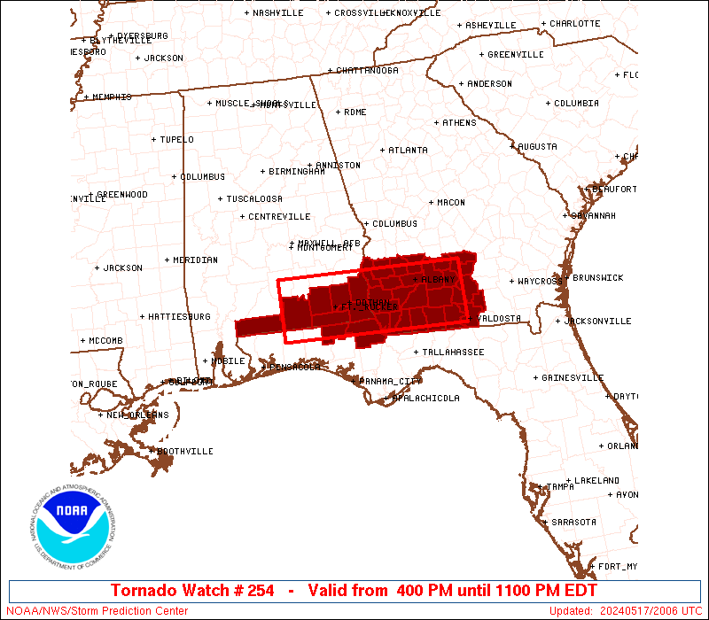
| Aviation Watch (SAW) for WW254 |
|---|
 |
| Note:
The Aviation Watch (SAW) product is an approximation to the watch area.
The actual watch is depicted by the shaded areas. |
   SAW4
   WW 254 TORNADO AL FL GA 172000Z - 180300Z
   AXIS..35 STATUTE MILES NORTH AND SOUTH OF LINE..
   75W DHN/DOTHAN AL/ - 30ENE MGR/MOULTRIE GA/
   ..AVIATION COORDS.. 30NM N/S /29N CEW - 46WSW AMG/
   HAIL SURFACE AND ALOFT..2 INCHES. WIND GUSTS..60 KNOTS.
   MAX TOPS TO 500. MEAN STORM MOTION VECTOR 27030.

   LAT...LON 31828672 31758333 30748333 30818672

   THIS IS AN APPROXIMATION TO THE WATCH AREA.  FOR A
   COMPLETE DEPICTION OF THE WATCH SEE WOUS64 KWNS
   FOR WOU4.
|
|


 @NWSSPC