Note:
The expiration time in the watch graphic is amended if the watch is
replaced, cancelled or extended.
Note:
Note:
The expiration time in the watch graphic is amended if the watch is
replaced, cancelled or extended.
Note: Click for
Watch Status Reports.
SEL1
URGENT - IMMEDIATE BROADCAST REQUESTED
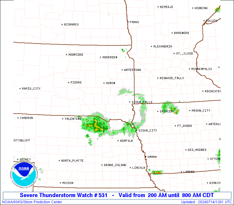
Severe Thunderstorm Watch Number 531
NWS Storm Prediction Center Norman OK
200 AM CDT Sun Jul 14 2024
The NWS Storm Prediction Center has issued a
* Severe Thunderstorm Watch for portions of
Northwestern Iowa
Southwestern Minnesota
Northeastern Nebraska
East-central and southeastern South Dakota
* Effective this Sunday morning from 200 AM until 800 AM CDT.
* Primary threats include...
Scattered damaging winds likely with isolated significant gusts
to 90 mph possible
Isolated large hail events to 1.5 inches in diameter possible
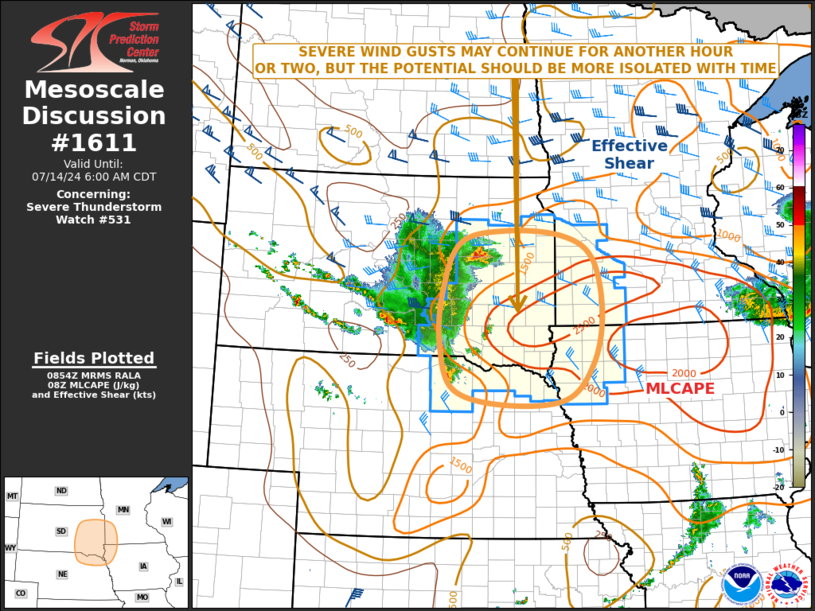
SUMMARY...A well-organized, bowing thunderstorm complex, with a
history of numerous, measured, significant severe gusts (65+ kt) in
western and central SD, should continue to pose a threat for severe
wind as it moves through much of the watch area through dawn.
The severe thunderstorm watch area is approximately along and 85
statute miles north and south of a line from 60 miles west of
Mitchell SD to 25 miles north northeast of Spencer IA. For a
complete depiction of the watch see the associated watch outline
update (WOUS64 KWNS WOU1).
PRECAUTIONARY/PREPAREDNESS ACTIONS...
REMEMBER...A Severe Thunderstorm Watch means conditions are
favorable for severe thunderstorms in and close to the watch area.
Persons in these areas should be on the lookout for threatening
weather conditions and listen for later statements and possible
warnings. Severe thunderstorms can and occasionally do produce
tornadoes.
&&
OTHER WATCH INFORMATION...CONTINUE...WW 527...WW 528...WW
529...WW 530...
AVIATION...A few severe thunderstorms with hail surface and aloft to
1.5 inches. Extreme turbulence and surface wind gusts to 80 knots. A
few cumulonimbi with maximum tops to 550. Mean storm motion vector
29050.
...Edwards

   SEL1

   URGENT - IMMEDIATE BROADCAST REQUESTED
   Severe Thunderstorm Watch Number 531
   NWS Storm Prediction Center Norman OK
   200 AM CDT Sun Jul 14 2024

   The NWS Storm Prediction Center has issued a

   * Severe Thunderstorm Watch for portions of
     Northwestern Iowa
     Southwestern Minnesota
     Northeastern Nebraska
     East-central and southeastern South Dakota

   * Effective this Sunday morning from 200 AM until 800 AM CDT.

   * Primary threats include...
     Scattered damaging winds likely with isolated significant gusts
       to 90 mph possible
     Isolated large hail events to 1.5 inches in diameter possible

   SUMMARY...A well-organized, bowing thunderstorm complex, with a
   history of numerous, measured, significant severe gusts (65+ kt) in
   western and central SD, should continue to pose a threat for severe
   wind as it moves through much of the watch area through dawn.

   The severe thunderstorm watch area is approximately along and 85
   statute miles north and south of a line from 60 miles west of
   Mitchell SD to 25 miles north northeast of Spencer IA. For a
   complete depiction of the watch see the associated watch outline
   update (WOUS64 KWNS WOU1).

   PRECAUTIONARY/PREPAREDNESS ACTIONS...

   REMEMBER...A Severe Thunderstorm Watch means conditions are
   favorable for severe thunderstorms in and close to the watch area.
   Persons in these areas should be on the lookout for threatening
   weather conditions and listen for later statements and possible
   warnings. Severe thunderstorms can and occasionally do produce
   tornadoes.

   &&

   OTHER WATCH INFORMATION...CONTINUE...WW 527...WW 528...WW
   529...WW 530...

   AVIATION...A few severe thunderstorms with hail surface and aloft to
   1.5 inches. Extreme turbulence and surface wind gusts to 80 knots. A
   few cumulonimbi with maximum tops to 550. Mean storm motion vector
   29050.

   ...Edwards
 Note:
The Aviation Watch (SAW) product is an approximation to the watch area.
The actual watch is depicted by the shaded areas.
Note:
The Aviation Watch (SAW) product is an approximation to the watch area.
The actual watch is depicted by the shaded areas.
SAW1
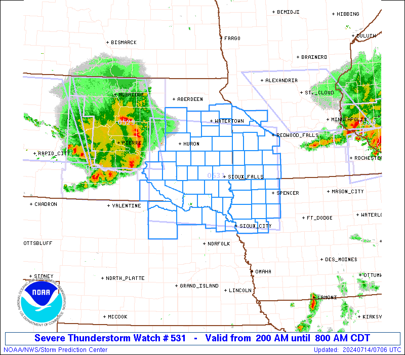
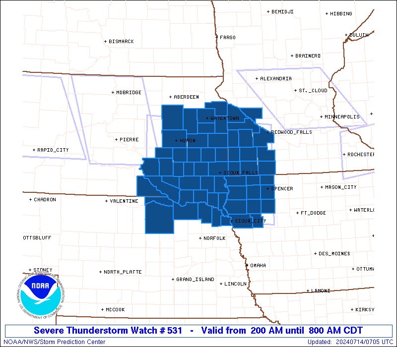
WW 531 SEVERE TSTM IA MN NE SD 140700Z - 141300Z
AXIS..85 STATUTE MILES NORTH AND SOUTH OF LINE..
60W MHE/MITCHELL SD/ - 25NNE SPW/SPENCER IA/
..AVIATION COORDS.. 75NM N/S /56SE PIR - 58S RWF/
HAIL SURFACE AND ALOFT..1.5 INCHES. WIND GUSTS..80 KNOTS.
MAX TOPS TO 550. MEAN STORM MOTION VECTOR 29050.
LAT...LON 44999923 44739496 42279496 42539923
THIS IS AN APPROXIMATION TO THE WATCH AREA. FOR A
COMPLETE DEPICTION OF THE WATCH SEE WOUS64 KWNS
FOR WOU1.
Watch 531 Status Report Messages:
STATUS REPORT #3 ON WW 531

VALID 141130Z - 141240Z

SEVERE WEATHER THREAT CONTINUES RIGHT OF A LINE FROM 45 S 9V9 TO
45 NNE ONL TO 20 ESE MHE TO 20 SSW BKX TO 35 SSE RWF.

..BROYLES..07/14/24

ATTN...WFO...FSD...MPX...LBF...OAX...ABR...

&&

STATUS REPORT FOR WS 531

SEVERE WEATHER THREAT CONTINUES FOR THE FOLLOWING AREAS

IAC021-035-041-059-093-119-141-143-149-167-193-141240-

IA
.    IOWA COUNTIES INCLUDED ARE

BUENA VISTA	     CHEROKEE		 CLAY
DICKINSON	     IDA		 LYON
O'BRIEN 	     OSCEOLA		 PLYMOUTH
SIOUX		     WOODBURY
$$


MNC033-063-101-105-117-133-141240-

MN
.    MINNESOTA COUNTIES INCLUDED ARE

COTTONWOOD	     JACKSON		 MURRAY
NOBLES		     PIPESTONE		 ROCK
$$


NEC015-027-043-051-089-107-141240-

NE
.    NEBRASKA COUNTIES INCLUDED ARE

BOYD		     CEDAR		 DAKOTA
DIXON		     HOLT		 KNOX
$$


SDC009-027-067-083-087-099-101-125-127-135-141240-

SD
.    SOUTH DAKOTA COUNTIES INCLUDED ARE

BON HOMME	     CLAY		 HUTCHINSON
LINCOLN 	     MCCOOK		 MINNEHAHA
MOODY		     TURNER		 UNION
YANKTON
$$


THE WATCH STATUS MESSAGE IS FOR GUIDANCE PURPOSES ONLY.  PLEASE
REFER TO WATCH COUNTY NOTIFICATION STATEMENTS FOR OFFICIAL
INFORMATION ON COUNTIES...INDEPENDENT CITIES AND MARINE ZONES
CLEARED FROM SEVERE THUNDERSTORM AND TORNADO WATCHES.
$$

STATUS REPORT #2 ON WW 531

VALID 140940Z - 141040Z

THE SEVERE WEATHER THREAT CONTINUES ACROSS THE ENTIRE WATCH AREA.

..BROYLES..07/14/24

ATTN...WFO...FSD...MPX...LBF...OAX...ABR...

&&

STATUS REPORT FOR WS 531

SEVERE WEATHER THREAT CONTINUES FOR THE FOLLOWING AREAS

IAC021-035-041-059-093-119-141-143-149-167-193-141040-

IA
.    IOWA COUNTIES INCLUDED ARE

BUENA VISTA	     CHEROKEE		 CLAY
DICKINSON	     IDA		 LYON
O'BRIEN 	     OSCEOLA		 PLYMOUTH
SIOUX		     WOODBURY
$$


MNC023-033-063-073-081-083-101-105-117-127-133-173-141040-

MN
.    MINNESOTA COUNTIES INCLUDED ARE

CHIPPEWA	     COTTONWOOD 	 JACKSON
LAC QUI PARLE	     LINCOLN		 LYON
MURRAY		     NOBLES		 PIPESTONE
REDWOOD 	     ROCK		 YELLOW MEDICINE
$$


NEC015-027-043-051-089-107-141040-

NE
.    NEBRASKA COUNTIES INCLUDED ARE

BOYD		     CEDAR		 DAKOTA
DIXON		     HOLT		 KNOX
$$


SDC003-005-009-011-015-023-025-027-029-035-039-043-051-053-057-
061-067-073-077-079-083-087-097-099-101-111-115-125-127-135-
141040-

SD
.    SOUTH DAKOTA COUNTIES INCLUDED ARE

AURORA		     BEADLE		 BON HOMME
BROOKINGS	     BRULE		 CHARLES MIX
CLARK		     CLAY		 CODINGTON
DAVISON 	     DEUEL		 DOUGLAS
GRANT		     GREGORY		 HAMLIN
HANSON		     HUTCHINSON 	 JERAULD
KINGSBURY	     LAKE		 LINCOLN
MCCOOK		     MINER		 MINNEHAHA
MOODY		     SANBORN		 SPINK
TURNER		     UNION		 YANKTON
$$


THE WATCH STATUS MESSAGE IS FOR GUIDANCE PURPOSES ONLY.  PLEASE
REFER TO WATCH COUNTY NOTIFICATION STATEMENTS FOR OFFICIAL
INFORMATION ON COUNTIES...INDEPENDENT CITIES AND MARINE ZONES
CLEARED FROM SEVERE THUNDERSTORM AND TORNADO WATCHES.
$$

STATUS REPORT #1 ON WW 531

VALID 140730Z - 140840Z

THE SEVERE WEATHER THREAT CONTINUES ACROSS THE ENTIRE WATCH AREA.

..BROYLES..07/14/24

ATTN...WFO...FSD...MPX...LBF...OAX...ABR...

&&

STATUS REPORT FOR WS 531

SEVERE WEATHER THREAT CONTINUES FOR THE FOLLOWING AREAS

IAC021-035-041-059-093-119-141-143-149-167-193-140840-

IA
.    IOWA COUNTIES INCLUDED ARE

BUENA VISTA	     CHEROKEE		 CLAY
DICKINSON	     IDA		 LYON
O'BRIEN 	     OSCEOLA		 PLYMOUTH
SIOUX		     WOODBURY
$$


MNC023-033-063-073-081-083-101-105-117-127-133-173-140840-

MN
.    MINNESOTA COUNTIES INCLUDED ARE

CHIPPEWA	     COTTONWOOD 	 JACKSON
LAC QUI PARLE	     LINCOLN		 LYON
MURRAY		     NOBLES		 PIPESTONE
REDWOOD 	     ROCK		 YELLOW MEDICINE
$$


NEC015-027-043-051-089-107-140840-

NE
.    NEBRASKA COUNTIES INCLUDED ARE

BOYD		     CEDAR		 DAKOTA
DIXON		     HOLT		 KNOX
$$


SDC003-005-009-011-015-023-025-027-029-035-039-043-051-053-057-
061-067-073-077-079-083-087-097-099-101-111-115-125-127-135-
140840-

SD
.    SOUTH DAKOTA COUNTIES INCLUDED ARE

AURORA		     BEADLE		 BON HOMME
BROOKINGS	     BRULE		 CHARLES MIX
CLARK		     CLAY		 CODINGTON
DAVISON 	     DEUEL		 DOUGLAS
GRANT		     GREGORY		 HAMLIN
HANSON		     HUTCHINSON 	 JERAULD
KINGSBURY	     LAKE		 LINCOLN
MCCOOK		     MINER		 MINNEHAHA
MOODY		     SANBORN		 SPINK
TURNER		     UNION		 YANKTON
$$


THE WATCH STATUS MESSAGE IS FOR GUIDANCE PURPOSES ONLY.  PLEASE
REFER TO WATCH COUNTY NOTIFICATION STATEMENTS FOR OFFICIAL
INFORMATION ON COUNTIES...INDEPENDENT CITIES AND MARINE ZONES
CLEARED FROM SEVERE THUNDERSTORM AND TORNADO WATCHES.
$$
Note:
Click for Complete Product Text.
Tornadoes
Probability of 2 or more tornadoes
|
Low (10%)
|
Probability of 1 or more strong (EF2-EF5) tornadoes
|
Low (<2%)
|
Wind
Probability of 10 or more severe wind events
|
High (70%)
|
Probability of 1 or more wind events > 65 knots
|
Mod (40%)
|
Hail
Probability of 10 or more severe hail events
|
Low (20%)
|
Probability of 1 or more hailstones > 2 inches
|
Low (20%)
|
Combined Severe Hail/Wind
Probability of 6 or more combined severe hail/wind events
|
High (90%)
|
For each watch, probabilities for particular events inside the watch
(listed above in each table) are determined by the issuing forecaster.
The "Low" category contains probability values ranging from less than 2%
to 20% (EF2-EF5 tornadoes), less than 5% to 20% (all other probabilities),
"Moderate" from 30% to 60%, and "High" from 70% to greater than 95%.
High values are bolded and lighter in color to provide awareness of
an increased threat for a particular event.


 @NWSSPC