 Note:
The expiration time in the watch graphic is amended if the watch is
replaced, cancelled or extended.
Note:
Note:
The expiration time in the watch graphic is amended if the watch is
replaced, cancelled or extended.
Note: Click for
Watch Status Reports.
SEL7
URGENT - IMMEDIATE BROADCAST REQUESTED
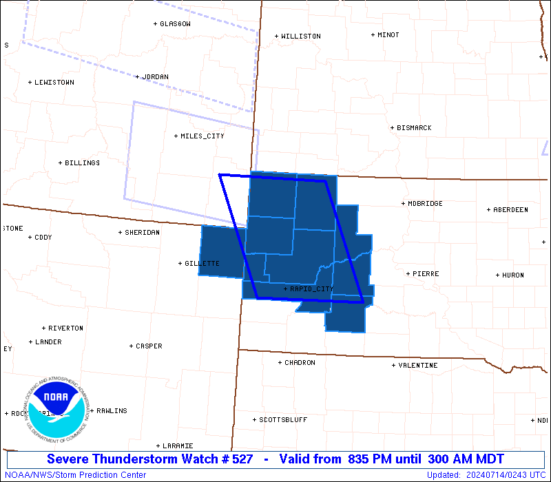
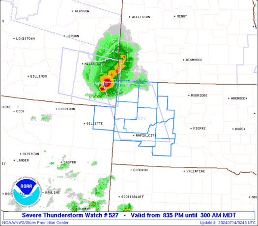
Severe Thunderstorm Watch Number 527
NWS Storm Prediction Center Norman OK
835 PM MDT Sat Jul 13 2024
The NWS Storm Prediction Center has issued a
* Severe Thunderstorm Watch for portions of
Western South Dakota
Far Northeast Wyoming
* Effective this Saturday night and Sunday morning from 835 PM
until 300 AM MDT.
* Primary threats include...
Scattered damaging winds likely with isolated significant gusts
to 75 mph possible
Scattered large hail and isolated very large hail events to 2
inches in diameter possible
SUMMARY...Intense thunderstorms will move quickly southeastward
across western South Dakota this evening while posing a threat for
severe/damaging winds generally up to 65-75 mph, and large hail
around 1-2 inches in diameter.
The severe thunderstorm watch area is approximately along and 60
statute miles east and west of a line from 20 miles north of Buffalo
SD to 30 miles east southeast of Rapid City SD. For a complete
depiction of the watch see the associated watch outline update
(WOUS64 KWNS WOU7).
PRECAUTIONARY/PREPAREDNESS ACTIONS...
REMEMBER...A Severe Thunderstorm Watch means conditions are
favorable for severe thunderstorms in and close to the watch area.
Persons in these areas should be on the lookout for threatening
weather conditions and listen for later statements and possible
warnings. Severe thunderstorms can and occasionally do produce
tornadoes.
&&
OTHER WATCH INFORMATION...CONTINUE...WW 522...WW 523...WW
524...WW 525...WW 526...
AVIATION...A few severe thunderstorms with hail surface and aloft to
2 inches. Extreme turbulence and surface wind gusts to 65 knots. A
few cumulonimbi with maximum tops to 500. Mean storm motion vector
32040.
...Gleason
   SEL7

   URGENT - IMMEDIATE BROADCAST REQUESTED
   Severe Thunderstorm Watch Number 527
   NWS Storm Prediction Center Norman OK
   835 PM MDT Sat Jul 13 2024

   The NWS Storm Prediction Center has issued a

   * Severe Thunderstorm Watch for portions of
     Western South Dakota
     Far Northeast Wyoming

   * Effective this Saturday night and Sunday morning from 835 PM
     until 300 AM MDT.

   * Primary threats include...
     Scattered damaging winds likely with isolated significant gusts
       to 75 mph possible
     Scattered large hail and isolated very large hail events to 2
       inches in diameter possible

   SUMMARY...Intense thunderstorms will move quickly southeastward
   across western South Dakota this evening while posing a threat for
   severe/damaging winds generally up to 65-75 mph, and large hail
   around 1-2 inches in diameter.

   The severe thunderstorm watch area is approximately along and 60
   statute miles east and west of a line from 20 miles north of Buffalo
   SD to 30 miles east southeast of Rapid City SD. For a complete
   depiction of the watch see the associated watch outline update
   (WOUS64 KWNS WOU7).

   PRECAUTIONARY/PREPAREDNESS ACTIONS...

   REMEMBER...A Severe Thunderstorm Watch means conditions are
   favorable for severe thunderstorms in and close to the watch area.
   Persons in these areas should be on the lookout for threatening
   weather conditions and listen for later statements and possible
   warnings. Severe thunderstorms can and occasionally do produce
   tornadoes.

   &&

   OTHER WATCH INFORMATION...CONTINUE...WW 522...WW 523...WW
   524...WW 525...WW 526...

   AVIATION...A few severe thunderstorms with hail surface and aloft to
   2 inches. Extreme turbulence and surface wind gusts to 65 knots. A
   few cumulonimbi with maximum tops to 500. Mean storm motion vector
   32040.

   ...Gleason
 Note:
The Aviation Watch (SAW) product is an approximation to the watch area.
The actual watch is depicted by the shaded areas.
Note:
The Aviation Watch (SAW) product is an approximation to the watch area.
The actual watch is depicted by the shaded areas.
   SAW7
   WW 527 SEVERE TSTM SD WY 140235Z - 140900Z
   AXIS..60 STATUTE MILES EAST AND WEST OF LINE..
   20N 2WX/BUFFALO SD/ - 30ESE RAP/RAPID CITY SD/
   ..AVIATION COORDS.. 50NM E/W /68SSW DIK - 23ESE RAP/
   HAIL SURFACE AND ALOFT..2 INCHES. WIND GUSTS..65 KNOTS.
   MAX TOPS TO 500. MEAN STORM MOTION VECTOR 32040.

   LAT...LON 45850227 43880129 43880370 45850477

   THIS IS AN APPROXIMATION TO THE WATCH AREA.  FOR A
   COMPLETE DEPICTION OF THE WATCH SEE WOUS64 KWNS
   FOR WOU7.
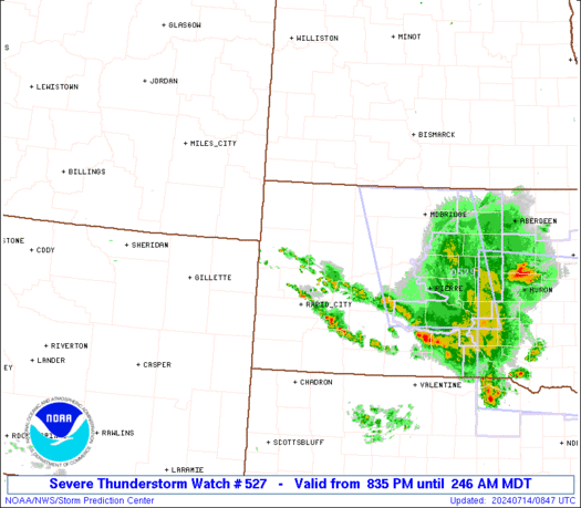
Watch 527 Status Report Messages:
STATUS REPORT #2 ON WW 527

VALID 140430Z - 140540Z

SEVERE WEATHER THREAT CONTINUES RIGHT OF A LINE FROM 60 WNW RAP
TO 10 W Y22.

FOR ADDITIONAL INFORMATION SEE MESOSCALE DISCUSSION 1606.

..GRAMS..07/14/24

ATTN...WFO...UNR...

&&

STATUS REPORT FOR WS 527

SEVERE WEATHER THREAT CONTINUES FOR THE FOLLOWING AREAS

SDC019-055-071-093-103-105-137-140540-

SD
.    SOUTH DAKOTA COUNTIES INCLUDED ARE

BUTTE		     HAAKON		 JACKSON
MEADE		     PENNINGTON 	 PERKINS
ZIEBACH
$$


THE WATCH STATUS MESSAGE IS FOR GUIDANCE PURPOSES ONLY.  PLEASE
REFER TO WATCH COUNTY NOTIFICATION STATEMENTS FOR OFFICIAL
INFORMATION ON COUNTIES...INDEPENDENT CITIES AND MARINE ZONES
CLEARED FROM SEVERE THUNDERSTORM AND TORNADO WATCHES.
$$

STATUS REPORT #1 ON WW 527

VALID 140400Z - 140540Z

SEVERE WEATHER THREAT CONTINUES RIGHT OF A LINE FROM 65 W RAP TO
35 WSW 2WX TO 35 NW Y22.

FOR ADDITIONAL INFORMATION SEE MESOSCALE DISCUSSION 1606

..MOORE..07/14/24

ATTN...WFO...UNR...

&&

STATUS REPORT FOR WS 527

SEVERE WEATHER THREAT CONTINUES FOR THE FOLLOWING AREAS

SDC019-055-063-071-081-093-103-105-137-140540-

SD
.    SOUTH DAKOTA COUNTIES INCLUDED ARE

BUTTE		     HAAKON		 HARDING
JACKSON 	     LAWRENCE		 MEADE
PENNINGTON	     PERKINS		 ZIEBACH
$$


THE WATCH STATUS MESSAGE IS FOR GUIDANCE PURPOSES ONLY.  PLEASE
REFER TO WATCH COUNTY NOTIFICATION STATEMENTS FOR OFFICIAL
INFORMATION ON COUNTIES...INDEPENDENT CITIES AND MARINE ZONES
CLEARED FROM SEVERE THUNDERSTORM AND TORNADO WATCHES.
$$
Note:
Click for Complete Product Text.
Tornadoes
Probability of 2 or more tornadoes
|
Low (10%)
|
Probability of 1 or more strong (EF2-EF5) tornadoes
|
Low (<2%)
|
Wind
Probability of 10 or more severe wind events
|
Mod (60%)
|
Probability of 1 or more wind events > 65 knots
|
Mod (50%)
|
Hail
Probability of 10 or more severe hail events
|
Mod (40%)
|
Probability of 1 or more hailstones > 2 inches
|
Mod (30%)
|
Combined Severe Hail/Wind
Probability of 6 or more combined severe hail/wind events
|
High (90%)
|
For each watch, probabilities for particular events inside the watch
(listed above in each table) are determined by the issuing forecaster.
The "Low" category contains probability values ranging from less than 2%
to 20% (EF2-EF5 tornadoes), less than 5% to 20% (all other probabilities),
"Moderate" from 30% to 60%, and "High" from 70% to greater than 95%.
High values are bolded and lighter in color to provide awareness of
an increased threat for a particular event.


 @NWSSPC