 Note:
The expiration time in the watch graphic is amended if the watch is
replaced, cancelled or extended.
Note:
Note:
The expiration time in the watch graphic is amended if the watch is
replaced, cancelled or extended.
Note: Click for
Watch Status Reports.
SEL8
URGENT - IMMEDIATE BROADCAST REQUESTED
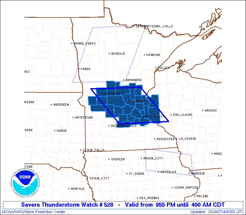
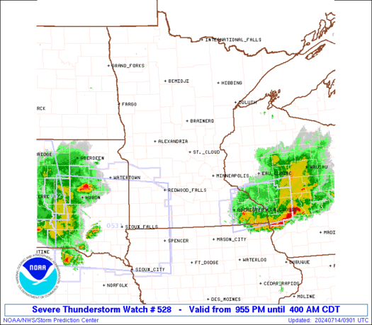
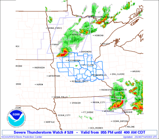
Severe Thunderstorm Watch Number 528
NWS Storm Prediction Center Norman OK
955 PM CDT Sat Jul 13 2024
The NWS Storm Prediction Center has issued a
* Severe Thunderstorm Watch for portions of
Central Minnesota
Far West-Central Wisconsin
* Effective this Saturday night and Sunday morning from 955 PM
until 400 AM CDT.
* Primary threats include...
Scattered damaging winds likely with isolated significant gusts
to 75 mph possible
Isolated large hail events to 1.5 inches in diameter possible
A tornado or two possible
SUMMARY...A small bowing complex of thunderstorms should move
southeastward this evening and overnight, posing a threat for mainly
severe/damaging winds around 60-70 mph. Occasionally stronger gusts
up to 75 mph appear possible, along with isolated large hail around
1-1.5 inches in diameter.
The severe thunderstorm watch area is approximately along and 70
statute miles east and west of a line from 40 miles east northeast
of Alexandria MN to 20 miles south southeast of Minneapolis MN. For
a complete depiction of the watch see the associated watch outline
update (WOUS64 KWNS WOU8).
PRECAUTIONARY/PREPAREDNESS ACTIONS...
REMEMBER...A Severe Thunderstorm Watch means conditions are
favorable for severe thunderstorms in and close to the watch area.
Persons in these areas should be on the lookout for threatening
weather conditions and listen for later statements and possible
warnings. Severe thunderstorms can and occasionally do produce
tornadoes.
&&
OTHER WATCH INFORMATION...CONTINUE...WW 522...WW 523...WW
524...WW 525...WW 526...WW 527...
AVIATION...A few severe thunderstorms with hail surface and aloft to
1.5 inches. Extreme turbulence and surface wind gusts to 65 knots. A
few cumulonimbi with maximum tops to 500. Mean storm motion vector
30035.
...Gleason
   SEL8

   URGENT - IMMEDIATE BROADCAST REQUESTED
   Severe Thunderstorm Watch Number 528
   NWS Storm Prediction Center Norman OK
   955 PM CDT Sat Jul 13 2024

   The NWS Storm Prediction Center has issued a

   * Severe Thunderstorm Watch for portions of
     Central Minnesota
     Far West-Central Wisconsin

   * Effective this Saturday night and Sunday morning from 955 PM
     until 400 AM CDT.

   * Primary threats include...
     Scattered damaging winds likely with isolated significant gusts
       to 75 mph possible
     Isolated large hail events to 1.5 inches in diameter possible
     A tornado or two possible

   SUMMARY...A small bowing complex of thunderstorms should move
   southeastward this evening and overnight, posing a threat for mainly
   severe/damaging winds around 60-70 mph. Occasionally stronger gusts
   up to 75 mph appear possible, along with isolated large hail around
   1-1.5 inches in diameter.

   The severe thunderstorm watch area is approximately along and 70
   statute miles east and west of a line from 40 miles east northeast
   of Alexandria MN to 20 miles south southeast of Minneapolis MN. For
   a complete depiction of the watch see the associated watch outline
   update (WOUS64 KWNS WOU8).

   PRECAUTIONARY/PREPAREDNESS ACTIONS...

   REMEMBER...A Severe Thunderstorm Watch means conditions are
   favorable for severe thunderstorms in and close to the watch area.
   Persons in these areas should be on the lookout for threatening
   weather conditions and listen for later statements and possible
   warnings. Severe thunderstorms can and occasionally do produce
   tornadoes.

   &&

   OTHER WATCH INFORMATION...CONTINUE...WW 522...WW 523...WW
   524...WW 525...WW 526...WW 527...

   AVIATION...A few severe thunderstorms with hail surface and aloft to
   1.5 inches. Extreme turbulence and surface wind gusts to 65 knots. A
   few cumulonimbi with maximum tops to 500. Mean storm motion vector
   30035.

   ...Gleason
 Note:
The Aviation Watch (SAW) product is an approximation to the watch area.
The actual watch is depicted by the shaded areas.
Note:
The Aviation Watch (SAW) product is an approximation to the watch area.
The actual watch is depicted by the shaded areas.
   SAW8
   WW 528 SEVERE TSTM MN WI 140255Z - 140900Z
   AXIS..70 STATUTE MILES EAST AND WEST OF LINE..
   40ENE AXN/ALEXANDRIA MN/ - 20SSE MSP/MINNEAPOLIS MN/
   ..AVIATION COORDS.. 60NM E/W /29WSW BRD - 18SSE MSP/
   HAIL SURFACE AND ALOFT..1.5 INCHES. WIND GUSTS..65 KNOTS.
   MAX TOPS TO 500. MEAN STORM MOTION VECTOR 30035.

   LAT...LON 46089317 44609164 44609449 46089609

   THIS IS AN APPROXIMATION TO THE WATCH AREA.  FOR A
   COMPLETE DEPICTION OF THE WATCH SEE WOUS64 KWNS
   FOR WOU8.
Watch 528 Status Report Messages:
STATUS REPORT #2 ON WW 528
VALID 140700Z - 140840Z
SEVERE WEATHER THREAT CONTINUES RIGHT OF A LINE FROM 30 WNW MKT
TO 25 SSW MSP TO 20 ESE MSP TO 35 ENE MSP TO 45 NW EAU.
..BROYLES..07/14/24
ATTN...WFO...MPX...
&&
STATUS REPORT FOR WS 528
SEVERE WEATHER THREAT CONTINUES FOR THE FOLLOWING AREAS
MNC049-131-140840-
MN
. MINNESOTA COUNTIES INCLUDED ARE
GOODHUE RICE
$$
WIC005-011-017-033-035-093-109-140840-
WI
. WISCONSIN COUNTIES INCLUDED ARE
BARRON BUFFALO CHIPPEWA
DUNN EAU CLAIRE PIERCE
ST. CROIX
$$
THE WATCH STATUS MESSAGE IS FOR GUIDANCE PURPOSES ONLY. PLEASE
REFER TO WATCH COUNTY NOTIFICATION STATEMENTS FOR OFFICIAL
INFORMATION ON COUNTIES...INDEPENDENT CITIES AND MARINE ZONES
CLEARED FROM SEVERE THUNDERSTORM AND TORNADO WATCHES.
$$
STATUS REPORT #1 ON WW 528
VALID 140430Z - 140540Z
THE SEVERE WEATHER THREAT CONTINUES ACROSS THE ENTIRE WATCH AREA.
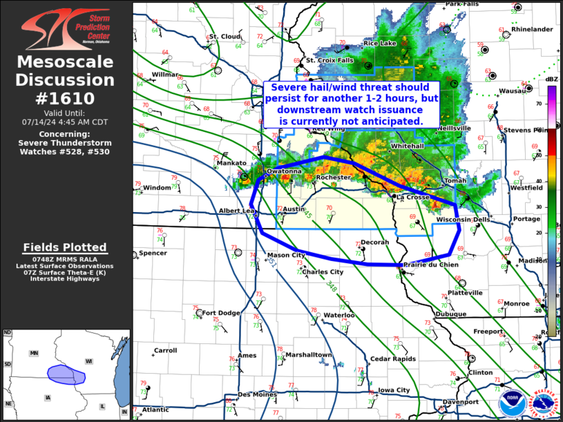
FOR ADDITIONAL INFORMATION SEE MESOSCALE DISCUSSION 1607.
..GRAMS..07/14/24
ATTN...WFO...MPX...
&&
STATUS REPORT FOR WS 528
SEVERE WEATHER THREAT CONTINUES FOR THE FOLLOWING AREAS
MNC003-009-019-025-037-041-053-059-065-067-085-093-095-097-121-
123-139-141-143-145-149-151-153-163-171-140540-
MN
. MINNESOTA COUNTIES INCLUDED ARE
ANOKA BENTON CARVER
CHISAGO DAKOTA DOUGLAS
HENNEPIN ISANTI KANABEC
KANDIYOHI MCLEOD MEEKER
MILLE LACS MORRISON POPE
RAMSEY SCOTT SHERBURNE
SIBLEY STEARNS STEVENS
SWIFT TODD WASHINGTON
WRIGHT
$$
WIC093-095-109-140540-
WI
. WISCONSIN COUNTIES INCLUDED ARE
PIERCE POLK ST. CROIX
$$
THE WATCH STATUS MESSAGE IS FOR GUIDANCE PURPOSES ONLY. PLEASE
REFER TO WATCH COUNTY NOTIFICATION STATEMENTS FOR OFFICIAL
INFORMATION ON COUNTIES...INDEPENDENT CITIES AND MARINE ZONES
CLEARED FROM SEVERE THUNDERSTORM AND TORNADO WATCHES.
$$
Note:
Click for Complete Product Text.
Tornadoes
Probability of 2 or more tornadoes
|
Low (20%)
|
Probability of 1 or more strong (EF2-EF5) tornadoes
|
Low (10%)
|
Wind
Probability of 10 or more severe wind events
|
Mod (60%)
|
Probability of 1 or more wind events > 65 knots
|
Mod (30%)
|
Hail
Probability of 10 or more severe hail events
|
Mod (30%)
|
Probability of 1 or more hailstones > 2 inches
|
Low (20%)
|
Combined Severe Hail/Wind
Probability of 6 or more combined severe hail/wind events
|
High (80%)
|
For each watch, probabilities for particular events inside the watch
(listed above in each table) are determined by the issuing forecaster.
The "Low" category contains probability values ranging from less than 2%
to 20% (EF2-EF5 tornadoes), less than 5% to 20% (all other probabilities),
"Moderate" from 30% to 60%, and "High" from 70% to greater than 95%.
High values are bolded and lighter in color to provide awareness of
an increased threat for a particular event.


 @NWSSPC