 Note:
The expiration time in the watch graphic is amended if the watch is
replaced, cancelled or extended.
Note:
Note:
The expiration time in the watch graphic is amended if the watch is
replaced, cancelled or extended.
Note: Click for
Watch Status Reports.
SEL3
URGENT - IMMEDIATE BROADCAST REQUESTED
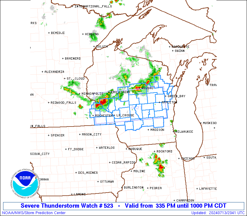
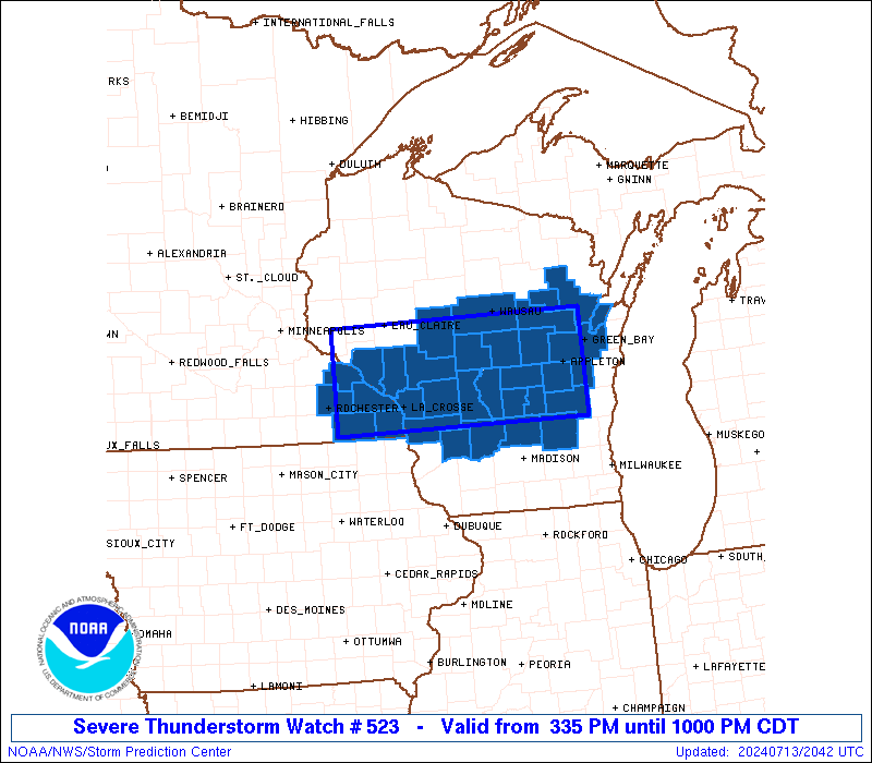
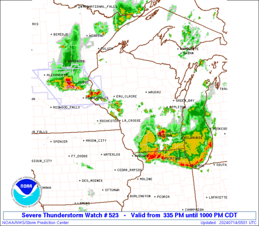
Severe Thunderstorm Watch Number 523
NWS Storm Prediction Center Norman OK
335 PM CDT Sat Jul 13 2024
The NWS Storm Prediction Center has issued a
* Severe Thunderstorm Watch for portions of
Southeast Minnesota
Central Wisconsin
Lake Michigan
* Effective this Saturday afternoon and evening from 335 PM until
1000 PM CDT.
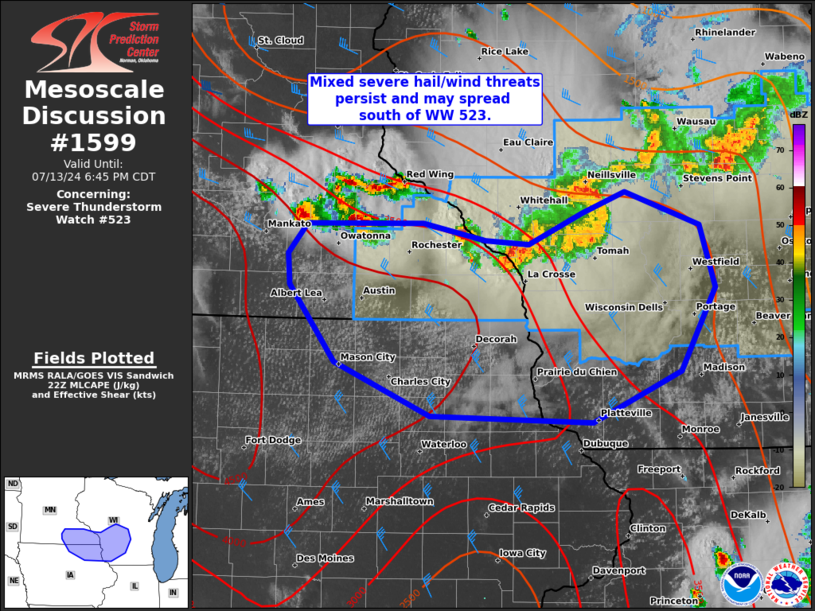
* Primary threats include...
Scattered damaging wind gusts to 70 mph possible
Isolated very large hail events to 2 inches in diameter possible
SUMMARY...Clusters of thunderstorms are expected to intensify and
track southeastward across the watch area through the afternoon and
early evening. The strongest storms will pose a risk of locally
damaging winds and hail.
The severe thunderstorm watch area is approximately along and 45
statute miles north and south of a line from 60 miles west northwest
of La Crosse WI to 25 miles northeast of Oshkosh WI. For a complete
depiction of the watch see the associated watch outline update
(WOUS64 KWNS WOU3).
PRECAUTIONARY/PREPAREDNESS ACTIONS...
REMEMBER...A Severe Thunderstorm Watch means conditions are
favorable for severe thunderstorms in and close to the watch area.
Persons in these areas should be on the lookout for threatening
weather conditions and listen for later statements and possible
warnings. Severe thunderstorms can and occasionally do produce
tornadoes.
&&
OTHER WATCH INFORMATION...CONTINUE...WW 522...
AVIATION...A few severe thunderstorms with hail surface and aloft to
2 inches. Extreme turbulence and surface wind gusts to 60 knots. A
few cumulonimbi with maximum tops to 500. Mean storm motion vector
29025.
...Hart
 Note:
The Aviation Watch (SAW) product is an approximation to the watch area.
The actual watch is depicted by the shaded areas.
Note:
The Aviation Watch (SAW) product is an approximation to the watch area.
The actual watch is depicted by the shaded areas.
   SAW3
   WW 523 SEVERE TSTM MN WI LM 132035Z - 140300Z
   AXIS..45 STATUTE MILES NORTH AND SOUTH OF LINE..
   60WNW LSE/LA CROSSE WI/ - 25NE OSH/OSHKOSH WI/
   ..AVIATION COORDS.. 40NM N/S /43WNW ODI - 19S GRB/
   HAIL SURFACE AND ALOFT..2 INCHES. WIND GUSTS..60 KNOTS.
   MAX TOPS TO 500. MEAN STORM MOTION VECTOR 29025.

   LAT...LON 44869237 44898819 43588819 43569237

   THIS IS AN APPROXIMATION TO THE WATCH AREA.  FOR A
   COMPLETE DEPICTION OF THE WATCH SEE WOUS64 KWNS
   FOR WOU3.
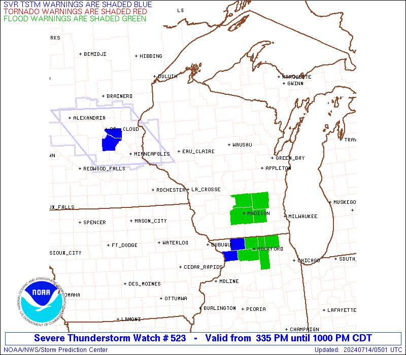
Watch 523 Status Report Messages:
STATUS REPORT #5 ON WW 523

VALID 140230Z - 140300Z

SEVERE WEATHER THREAT CONTINUES RIGHT OF A LINE FROM 15 SSE RST
TO 30 NE LNR TO 30 SE OSH.

WW 523 WILL BE ALLOWED TO EXPIRE AT 140300Z.

..GRAMS..07/14/24

ATTN...WFO...ARX...GRB...MKX...

&&

STATUS REPORT FOR WS 523

SEVERE WEATHER THREAT CONTINUES FOR THE FOLLOWING AREAS

WIC025-049-079-089-133-140300-

WI
.    WISCONSIN COUNTIES INCLUDED ARE

DANE		     IOWA		 MILWAUKEE
OZAUKEE 	     WAUKESHA
$$


LMZ643-644-645-669-671-673-140300-

CW

.    ADJACENT COASTAL WATERS INCLUDED ARE

SHEBOYGAN TO PORT WASHINGTON WI

PORT WASHINGTON TO NORTH POINT LIGHT WI

NORTH POINT LIGHT TO WIND POINT WI

LAKE MICHIGAN FROM SHEBOYGAN TO PORT WASHINGTON WI 5NM OFFSHORE
TO MID LAKE

LAKE MICHIGAN FROM PORT WASHINGTON TO NORTH POINT LIGHT WI 5NM
OFFSHORE TO MID LAKE

LAKE MICHIGAN FROM NORTH POINT LIGHT TO WIND POINT WI 5NM
OFFSHORE TO MID LAKE

$$
THE WATCH STATUS MESSAGE IS FOR GUIDANCE PURPOSES ONLY.  PLEASE
REFER TO WATCH COUNTY NOTIFICATION STATEMENTS FOR OFFICIAL
INFORMATION ON COUNTIES...INDEPENDENT CITIES AND MARINE ZONES
CLEARED FROM SEVERE THUNDERSTORM AND TORNADO WATCHES.
$$

STATUS REPORT #4 ON WW 523

VALID 140125Z - 140240Z

SEVERE WEATHER THREAT CONTINUES RIGHT OF A LINE FROM 5 E RST TO
25 N LNR TO 30 SSW OSH TO 15 SSW GRB.

..GRAMS..07/14/24

ATTN...WFO...ARX...GRB...MKX...

&&

STATUS REPORT FOR WS 523

SEVERE WEATHER THREAT CONTINUES FOR THE FOLLOWING AREAS

MNC045-055-140240-

MN
.    MINNESOTA COUNTIES INCLUDED ARE

FILLMORE	     HOUSTON
$$


WIC015-025-027-039-049-055-079-089-103-117-123-131-133-140240-

WI
.    WISCONSIN COUNTIES INCLUDED ARE

CALUMET 	     DANE		 DODGE
FOND DU LAC	     IOWA		 JEFFERSON
MILWAUKEE	     OZAUKEE		 RICHLAND
SHEBOYGAN	     VERNON		 WASHINGTON
WAUKESHA
$$


LMZ643-644-645-669-671-673-140240-

CW

.    ADJACENT COASTAL WATERS INCLUDED ARE

SHEBOYGAN TO PORT WASHINGTON WI

PORT WASHINGTON TO NORTH POINT LIGHT WI

NORTH POINT LIGHT TO WIND POINT WI

LAKE MICHIGAN FROM SHEBOYGAN TO PORT WASHINGTON WI 5NM OFFSHORE
TO MID LAKE

LAKE MICHIGAN FROM PORT WASHINGTON TO NORTH POINT LIGHT WI 5NM
OFFSHORE TO MID LAKE

LAKE MICHIGAN FROM NORTH POINT LIGHT TO WIND POINT WI 5NM
OFFSHORE TO MID LAKE

$$
THE WATCH STATUS MESSAGE IS FOR GUIDANCE PURPOSES ONLY.  PLEASE
REFER TO WATCH COUNTY NOTIFICATION STATEMENTS FOR OFFICIAL
INFORMATION ON COUNTIES...INDEPENDENT CITIES AND MARINE ZONES
CLEARED FROM SEVERE THUNDERSTORM AND TORNADO WATCHES.
$$

STATUS REPORT #3 ON WW 523

VALID 140020Z - 140140Z

SEVERE WEATHER THREAT CONTINUES RIGHT OF A LINE FROM 30 NW RST TO
30 WNW LSE TO 25 ENE LSE TO 10 ENE VOK TO 35 SSE CWA TO 55 NE GRB.

..LYONS..07/14/24

ATTN...WFO...ARX...GRB...MKX...

&&

STATUS REPORT FOR WS 523

SEVERE WEATHER THREAT CONTINUES FOR THE FOLLOWING AREAS

MNC039-045-055-099-109-169-140140-

MN
.    MINNESOTA COUNTIES INCLUDED ARE

DODGE		     FILLMORE		 HOUSTON
MOWER		     OLMSTED		 WINONA
$$


WIC001-009-015-021-025-027-039-047-049-055-057-063-077-079-081-
087-089-103-111-117-123-131-133-135-137-139-140140-

WI
.    WISCONSIN COUNTIES INCLUDED ARE

ADAMS		     BROWN		 CALUMET
COLUMBIA	     DANE		 DODGE
FOND DU LAC	     GREEN LAKE 	 IOWA
JEFFERSON	     JUNEAU		 LA CROSSE
MARQUETTE	     MILWAUKEE		 MONROE
OUTAGAMIE	     OZAUKEE		 RICHLAND
SAUK		     SHEBOYGAN		 VERNON
WASHINGTON	     WAUKESHA		 WAUPACA
WAUSHARA	     WINNEBAGO
$$


LMZ522-643-644-645-669-671-673-140140-

CW

.    ADJACENT COASTAL WATERS INCLUDED ARE

GREEN BAY SOUTH OF LINE FROM  OCONTO WI TO LITTLE STURGEON BAY WI

SHEBOYGAN TO PORT WASHINGTON WI

PORT WASHINGTON TO NORTH POINT LIGHT WI

NORTH POINT LIGHT TO WIND POINT WI

LAKE MICHIGAN FROM SHEBOYGAN TO PORT WASHINGTON WI 5NM OFFSHORE
TO MID LAKE

LAKE MICHIGAN FROM PORT WASHINGTON TO NORTH POINT LIGHT WI 5NM
OFFSHORE TO MID LAKE

LAKE MICHIGAN FROM NORTH POINT LIGHT TO WIND POINT WI 5NM
OFFSHORE TO MID LAKE

$$
THE WATCH STATUS MESSAGE IS FOR GUIDANCE PURPOSES ONLY.  PLEASE
REFER TO WATCH COUNTY NOTIFICATION STATEMENTS FOR OFFICIAL
INFORMATION ON COUNTIES...INDEPENDENT CITIES AND MARINE ZONES
CLEARED FROM SEVERE THUNDERSTORM AND TORNADO WATCHES.
$$

STATUS REPORT #2 ON WW 523

VALID 132305Z - 140040Z

SEVERE WEATHER THREAT CONTINUES RIGHT OF A LINE FROM 40 ESE MSP
TO 30 N LSE TO 30 NNW VOK TO 15 WSW CWA TO 25 ENE AUW.

..LYONS..07/13/24

ATTN...WFO...ARX...GRB...MKX...

&&

STATUS REPORT FOR WS 523

SEVERE WEATHER THREAT CONTINUES FOR THE FOLLOWING AREAS

MNC039-045-055-099-109-157-169-140040-

MN
.    MINNESOTA COUNTIES INCLUDED ARE

DODGE		     FILLMORE		 HOUSTON
MOWER		     OLMSTED		 WABASHA
WINONA
$$


WIC001-009-011-015-021-027-039-047-053-057-063-077-078-081-083-
087-097-103-111-115-121-123-135-137-139-141-140040-

WI
.    WISCONSIN COUNTIES INCLUDED ARE

ADAMS		     BROWN		 BUFFALO
CALUMET 	     COLUMBIA		 DODGE
FOND DU LAC	     GREEN LAKE 	 JACKSON
JUNEAU		     LA CROSSE		 MARQUETTE
MENOMINEE	     MONROE		 OCONTO
OUTAGAMIE	     PORTAGE		 RICHLAND
SAUK		     SHAWANO		 TREMPEALEAU
VERNON		     WAUPACA		 WAUSHARA
WINNEBAGO	     WOOD
$$


LMZ522-140040-

CW

.    ADJACENT COASTAL WATERS INCLUDED ARE

GREEN BAY SOUTH OF LINE FROM  OCONTO WI TO LITTLE STURGEON BAY WI

$$
THE WATCH STATUS MESSAGE IS FOR GUIDANCE PURPOSES ONLY.  PLEASE
REFER TO WATCH COUNTY NOTIFICATION STATEMENTS FOR OFFICIAL
INFORMATION ON COUNTIES...INDEPENDENT CITIES AND MARINE ZONES
CLEARED FROM SEVERE THUNDERSTORM AND TORNADO WATCHES.
$$

STATUS REPORT #1 ON WW 523

VALID 132140Z - 132240Z

THE SEVERE WEATHER THREAT CONTINUES ACROSS THE ENTIRE WATCH AREA.

..LYONS..07/13/24

ATTN...WFO...ARX...GRB...MKX...

&&

STATUS REPORT FOR WS 523

SEVERE WEATHER THREAT CONTINUES FOR THE FOLLOWING AREAS

MNC045-055-109-157-169-132240-

MN
.    MINNESOTA COUNTIES INCLUDED ARE

FILLMORE	     HOUSTON		 OLMSTED
WABASHA 	     WINONA
$$


WIC001-009-011-015-019-021-027-039-047-053-057-063-073-077-078-
081-083-087-097-103-111-115-121-123-135-137-139-141-132240-

WI
.    WISCONSIN COUNTIES INCLUDED ARE

ADAMS		     BROWN		 BUFFALO
CALUMET 	     CLARK		 COLUMBIA
DODGE		     FOND DU LAC	 GREEN LAKE
JACKSON 	     JUNEAU		 LA CROSSE
MARATHON	     MARQUETTE		 MENOMINEE
MONROE		     OCONTO		 OUTAGAMIE
PORTAGE 	     RICHLAND		 SAUK
SHAWANO 	     TREMPEALEAU	 VERNON
WAUPACA 	     WAUSHARA		 WINNEBAGO
WOOD
$$


LMZ522-132240-

CW

.    ADJACENT COASTAL WATERS INCLUDED ARE

GREEN BAY SOUTH OF LINE FROM  OCONTO WI TO LITTLE STURGEON BAY WI

$$
THE WATCH STATUS MESSAGE IS FOR GUIDANCE PURPOSES ONLY.  PLEASE
REFER TO WATCH COUNTY NOTIFICATION STATEMENTS FOR OFFICIAL
INFORMATION ON COUNTIES...INDEPENDENT CITIES AND MARINE ZONES
CLEARED FROM SEVERE THUNDERSTORM AND TORNADO WATCHES.
$$
Note:
Click for Complete Product Text.
Tornadoes
Probability of 2 or more tornadoes
|
Low (10%)
|
Probability of 1 or more strong (EF2-EF5) tornadoes
|
Low (<2%)
|
Wind
Probability of 10 or more severe wind events
|
Mod (40%)
|
Probability of 1 or more wind events > 65 knots
|
Low (20%)
|
Hail
Probability of 10 or more severe hail events
|
Mod (30%)
|
Probability of 1 or more hailstones > 2 inches
|
Mod (30%)
|
Combined Severe Hail/Wind
Probability of 6 or more combined severe hail/wind events
|
High (70%)
|
For each watch, probabilities for particular events inside the watch
(listed above in each table) are determined by the issuing forecaster.
The "Low" category contains probability values ranging from less than 2%
to 20% (EF2-EF5 tornadoes), less than 5% to 20% (all other probabilities),
"Moderate" from 30% to 60%, and "High" from 70% to greater than 95%.
High values are bolded and lighter in color to provide awareness of
an increased threat for a particular event.


 @NWSSPC