 Note:
The expiration time in the watch graphic is amended if the watch is
replaced, cancelled or extended.
Note:
Note:
The expiration time in the watch graphic is amended if the watch is
replaced, cancelled or extended.
Note: Click for
Watch Status Reports.
SEL5
URGENT - IMMEDIATE BROADCAST REQUESTED
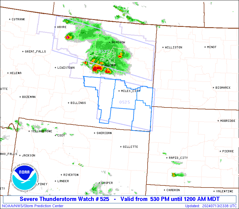
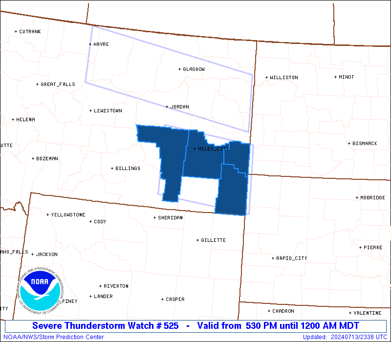
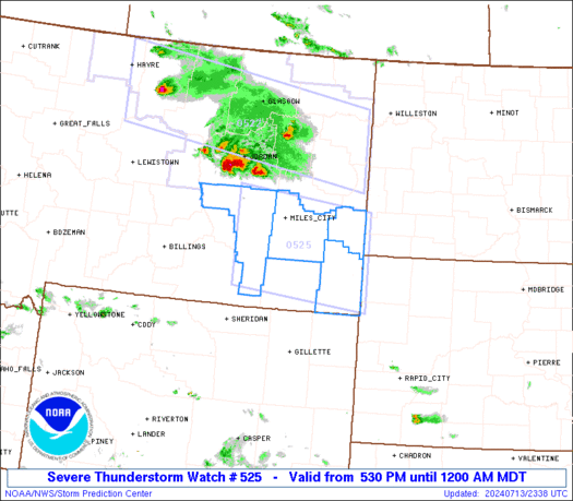
Severe Thunderstorm Watch Number 525
NWS Storm Prediction Center Norman OK
530 PM MDT Sat Jul 13 2024
The NWS Storm Prediction Center has issued a
* Severe Thunderstorm Watch for portions of
Southeast Montana
* Effective this Saturday afternoon from 530 PM until Midnight
MDT.
* Primary threats include...
Scattered damaging winds likely with isolated significant gusts
to 75 mph possible
Scattered large hail and isolated very large hail events to 2.5
inches in diameter possible
SUMMARY...Thunderstorms will continue to develop southeastward this
evening while posing a threat for scattered large to very large hail
(generally 1.5-2.5 inches in diameter). This activity should grow
into a small bowing cluster over the next few hours, with a greater
threat for severe winds potentially up to 65-75 mph.
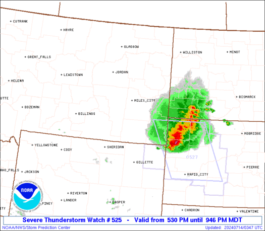
The severe thunderstorm watch area is approximately along and 55
statute miles north and south of a line from 55 miles west southwest
of Miles City MT to 40 miles south southeast of Baker MT. For a
complete depiction of the watch see the associated watch outline
update (WOUS64 KWNS WOU5).
PRECAUTIONARY/PREPAREDNESS ACTIONS...
REMEMBER...A Severe Thunderstorm Watch means conditions are
favorable for severe thunderstorms in and close to the watch area.
Persons in these areas should be on the lookout for threatening
weather conditions and listen for later statements and possible
warnings. Severe thunderstorms can and occasionally do produce
tornadoes.
&&
OTHER WATCH INFORMATION...CONTINUE...WW 522...WW 523...WW 524...
AVIATION...A few severe thunderstorms with hail surface and aloft to
2.5 inches. Extreme turbulence and surface wind gusts to 65 knots. A
few cumulonimbi with maximum tops to 500. Mean storm motion vector
30035.
...Gleason
   SEL5

   URGENT - IMMEDIATE BROADCAST REQUESTED
   Severe Thunderstorm Watch Number 525
   NWS Storm Prediction Center Norman OK
   530 PM MDT Sat Jul 13 2024

   The NWS Storm Prediction Center has issued a

   * Severe Thunderstorm Watch for portions of
     Southeast Montana

   * Effective this Saturday afternoon from 530 PM until Midnight
     MDT.

   * Primary threats include...
     Scattered damaging winds likely with isolated significant gusts
       to 75 mph possible
     Scattered large hail and isolated very large hail events to 2.5
       inches in diameter possible

   SUMMARY...Thunderstorms will continue to develop southeastward this
   evening while posing a threat for scattered large to very large hail
   (generally 1.5-2.5 inches in diameter). This activity should grow
   into a small bowing cluster over the next few hours, with a greater
   threat for severe winds potentially up to 65-75 mph.

   The severe thunderstorm watch area is approximately along and 55
   statute miles north and south of a line from 55 miles west southwest
   of Miles City MT to 40 miles south southeast of Baker MT. For a
   complete depiction of the watch see the associated watch outline
   update (WOUS64 KWNS WOU5).

   PRECAUTIONARY/PREPAREDNESS ACTIONS...

   REMEMBER...A Severe Thunderstorm Watch means conditions are
   favorable for severe thunderstorms in and close to the watch area.
   Persons in these areas should be on the lookout for threatening
   weather conditions and listen for later statements and possible
   warnings. Severe thunderstorms can and occasionally do produce
   tornadoes.

   &&

   OTHER WATCH INFORMATION...CONTINUE...WW 522...WW 523...WW 524...

   AVIATION...A few severe thunderstorms with hail surface and aloft to
   2.5 inches. Extreme turbulence and surface wind gusts to 65 knots. A
   few cumulonimbi with maximum tops to 500. Mean storm motion vector
   30035.

   ...Gleason
 Note:
The Aviation Watch (SAW) product is an approximation to the watch area.
The actual watch is depicted by the shaded areas.
Note:
The Aviation Watch (SAW) product is an approximation to the watch area.
The actual watch is depicted by the shaded areas.
SAW5
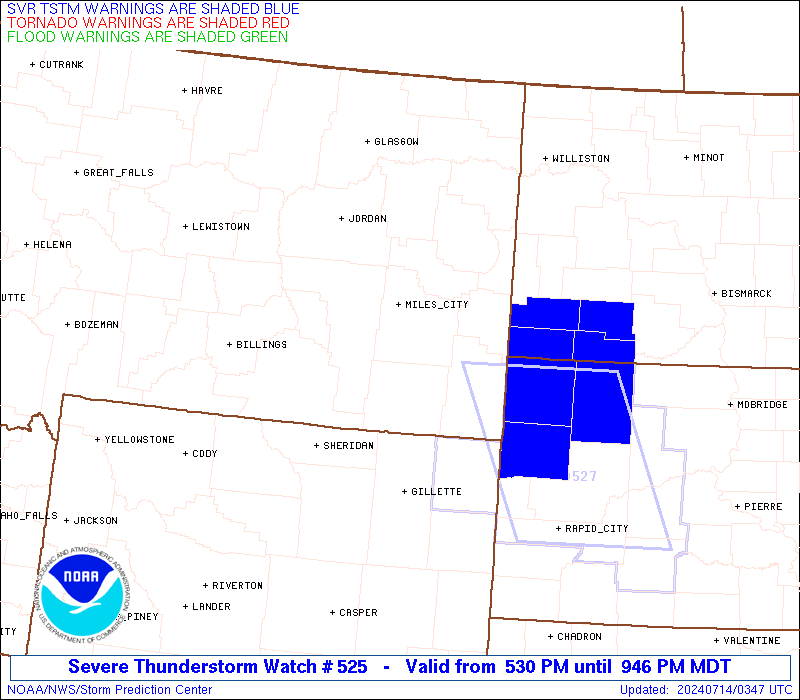
WW 525 SEVERE TSTM MT 132330Z - 140600Z
AXIS..55 STATUTE MILES NORTH AND SOUTH OF LINE..
55WSW MLS/MILES CITY MT/ - 40SSE BHK/BAKER MT/
..AVIATION COORDS.. 50NM N/S /44WSW MLS - 79SW DIK/
HAIL SURFACE AND ALOFT..2.5 INCHES. WIND GUSTS..65 KNOTS.
MAX TOPS TO 500. MEAN STORM MOTION VECTOR 30035.
LAT...LON 46920694 46620393 45030393 45320694
THIS IS AN APPROXIMATION TO THE WATCH AREA. FOR A
COMPLETE DEPICTION OF THE WATCH SEE WOUS64 KWNS
FOR WOU5.
Watch 525 Status Report Messages:
STATUS REPORT #3 ON WW 525
VALID 140250Z - 140340Z
SEVERE WEATHER THREAT CONTINUES RIGHT OF A LINE FROM 25 NE GCC TO
35 WSW BHK TO 45 NE BHK.
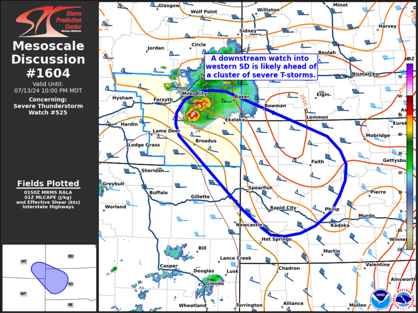
FOR ADDITIONAL INFORMATION SEE MESOSCALE DISCUSSION 1604
..MOORE..07/14/24
ATTN...WFO...BYZ...
&&
STATUS REPORT FOR WS 525
SEVERE WEATHER THREAT CONTINUES FOR THE FOLLOWING AREAS
MTC011-025-140340-
MT
. MONTANA COUNTIES INCLUDED ARE
CARTER FALLON
$$
THE WATCH STATUS MESSAGE IS FOR GUIDANCE PURPOSES ONLY. PLEASE
REFER TO WATCH COUNTY NOTIFICATION STATEMENTS FOR OFFICIAL
INFORMATION ON COUNTIES...INDEPENDENT CITIES AND MARINE ZONES
CLEARED FROM SEVERE THUNDERSTORM AND TORNADO WATCHES.
$$
STATUS REPORT #2 ON WW 525
VALID 140215Z - 140340Z
SEVERE WEATHER THREAT CONTINUES RIGHT OF A LINE FROM 40 ENE SHR
TO 25 SSW MLS TO 25 ESE GDV.
FOR ADDITIONAL INFORMATION SEE MESOSCALE DISCUSSION 1602
..MOORE..07/14/24
ATTN...WFO...BYZ...
&&
STATUS REPORT FOR WS 525
SEVERE WEATHER THREAT CONTINUES FOR THE FOLLOWING AREAS
MTC011-017-025-075-140340-
MT
. MONTANA COUNTIES INCLUDED ARE
CARTER CUSTER FALLON
POWDER RIVER
$$
THE WATCH STATUS MESSAGE IS FOR GUIDANCE PURPOSES ONLY. PLEASE
REFER TO WATCH COUNTY NOTIFICATION STATEMENTS FOR OFFICIAL
INFORMATION ON COUNTIES...INDEPENDENT CITIES AND MARINE ZONES
CLEARED FROM SEVERE THUNDERSTORM AND TORNADO WATCHES.
$$
STATUS REPORT #1 ON WW 525
VALID 140025Z - 140140Z
THE SEVERE WEATHER THREAT CONTINUES ACROSS THE ENTIRE WATCH AREA.
..LYONS..07/14/24
ATTN...WFO...BYZ...
&&
STATUS REPORT FOR WS 525
SEVERE WEATHER THREAT CONTINUES FOR THE FOLLOWING AREAS
MTC011-017-025-087-140140-
MT
. MONTANA COUNTIES INCLUDED ARE
CARTER CUSTER FALLON
ROSEBUD
$$
THE WATCH STATUS MESSAGE IS FOR GUIDANCE PURPOSES ONLY. PLEASE
REFER TO WATCH COUNTY NOTIFICATION STATEMENTS FOR OFFICIAL
INFORMATION ON COUNTIES...INDEPENDENT CITIES AND MARINE ZONES
CLEARED FROM SEVERE THUNDERSTORM AND TORNADO WATCHES.
$$
Note:
Click for Complete Product Text.
Tornadoes
Probability of 2 or more tornadoes
|
Low (10%)
|
Probability of 1 or more strong (EF2-EF5) tornadoes
|
Low (<2%)
|
Wind
Probability of 10 or more severe wind events
|
Mod (60%)
|
Probability of 1 or more wind events > 65 knots
|
Mod (40%)
|
Hail
Probability of 10 or more severe hail events
|
Mod (50%)
|
Probability of 1 or more hailstones > 2 inches
|
Mod (40%)
|
Combined Severe Hail/Wind
Probability of 6 or more combined severe hail/wind events
|
High (90%)
|
For each watch, probabilities for particular events inside the watch
(listed above in each table) are determined by the issuing forecaster.
The "Low" category contains probability values ranging from less than 2%
to 20% (EF2-EF5 tornadoes), less than 5% to 20% (all other probabilities),
"Moderate" from 30% to 60%, and "High" from 70% to greater than 95%.
High values are bolded and lighter in color to provide awareness of
an increased threat for a particular event.


 @NWSSPC