 Note:
The expiration time in the watch graphic is amended if the watch is
replaced, cancelled or extended.
Note:
Note:
The expiration time in the watch graphic is amended if the watch is
replaced, cancelled or extended.
Note: Click for
Watch Status Reports.
   SEL6

   URGENT - IMMEDIATE BROADCAST REQUESTED
   Tornado Watch Number 516
   NWS Storm Prediction Center Norman OK
   205 PM CDT Tue Jul 9 2024

   The NWS Storm Prediction Center has issued a

   * Tornado Watch for portions of
     Southern Illinois
     Southern Indiana
     Kentucky
     Southwest Ohio
     Middle Tennessee

   * Effective this Tuesday afternoon and evening from 205 PM until
     1100 PM CDT.

   * Primary threats include...
     Several tornadoes likely
     Isolated damaging wind gusts to 70 mph possible

   SUMMARY...A very moist environment and the remnants of Beryl, and
   its strong low-level winds, will be favorable for rotating storms
   capable of tornadoes, and possibly localized wind damage.

   The tornado watch area is approximately along and 95 statute miles
   north and south of a line from 10 miles north northwest of Paducah
   KY to 15 miles east northeast of Lexington KY. For a complete
   depiction of the watch see the associated watch outline update
   (WOUS64 KWNS WOU6).

   PRECAUTIONARY/PREPAREDNESS ACTIONS...

   REMEMBER...A Tornado Watch means conditions are favorable for
   tornadoes and severe thunderstorms in and close to the watch
   area. Persons in these areas should be on the lookout for
   threatening weather conditions and listen for later statements
   and possible warnings.

   &&

   AVIATION...Tornadoes and a few severe thunderstorms with hail
   surface and aloft to 0.5 inches. Extreme turbulence and surface wind
   gusts to 60 knots. A few cumulonimbi with maximum tops to 500. Mean
   storm motion vector 23040.

   ...Guyer
 Note:
The Aviation Watch (SAW) product is an approximation to the watch area.
The actual watch is depicted by the shaded areas.
Note:
The Aviation Watch (SAW) product is an approximation to the watch area.
The actual watch is depicted by the shaded areas.
   SAW6
   WW 516 TORNADO IL IN KY OH TN 091905Z - 100400Z
   AXIS..95 STATUTE MILES NORTH AND SOUTH OF LINE..
   10NNW PAH/PADUCAH KY/ - 15ENE LEX/LEXINGTON KY/
   ..AVIATION COORDS.. 85NM N/S /67SW PXV - 57SSE CVG/
   HAIL SURFACE AND ALOFT..0.5 INCH. WIND GUSTS..60 KNOTS.
   MAX TOPS TO 500. MEAN STORM MOTION VECTOR 23040.

   LAT...LON 38588884 39498435 36748435 35838884

   THIS IS AN APPROXIMATION TO THE WATCH AREA.  FOR A
   COMPLETE DEPICTION OF THE WATCH SEE WOUS64 KWNS
   FOR WOU6.
Watch 516 Status Report Messages:
STATUS REPORT #7 ON WW 516
VALID 100345Z - 100440Z
SEVERE WEATHER THREAT CONTINUES RIGHT OF A LINE FROM 40 NE LEX TO
40 WSW DAY.
..THORNTON..07/10/24
ATTN...WFO...PAH...ILX...IND...LMK...ILN...JKL...OHX...
&&
STATUS REPORT FOR WT 516
SEVERE WEATHER THREAT CONTINUES FOR THE FOLLOWING AREAS
KYC023-037-100440-
KY
. KENTUCKY COUNTIES INCLUDED ARE
BRACKEN CAMPBELL
$$
OHC017-025-061-135-165-100440-
OH
. OHIO COUNTIES INCLUDED ARE
BUTLER CLERMONT HAMILTON
PREBLE WARREN
$$
THE WATCH STATUS MESSAGE IS FOR GUIDANCE PURPOSES ONLY. PLEASE
REFER TO WATCH COUNTY NOTIFICATION STATEMENTS FOR OFFICIAL
INFORMATION ON COUNTIES...INDEPENDENT CITIES AND MARINE ZONES
CLEARED FROM SEVERE THUNDERSTORM AND TORNADO WATCHES.
$$
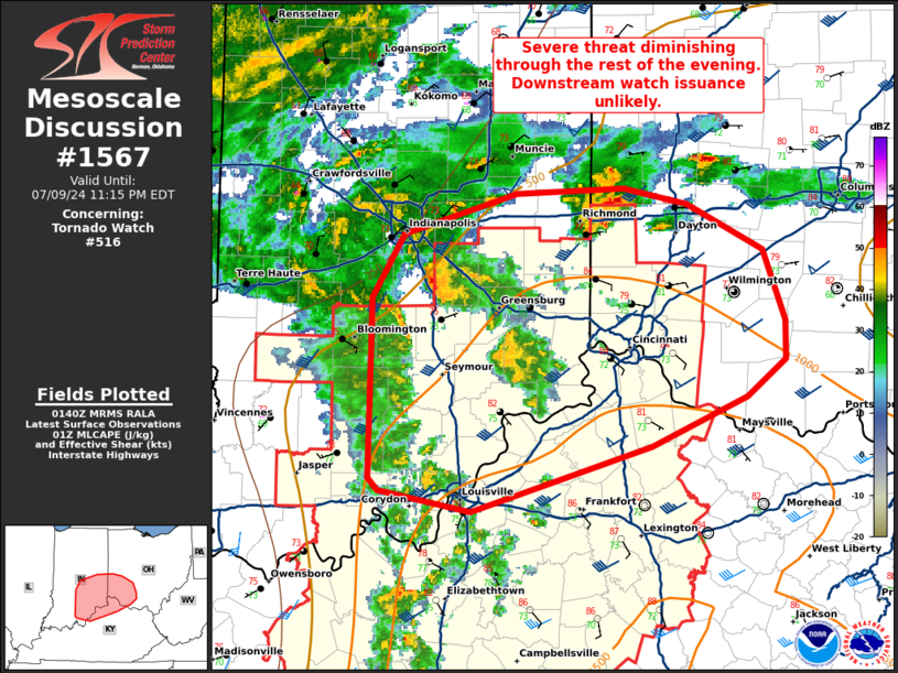
STATUS REPORT #6 ON WW 516
VALID 100240Z - 100340Z
SEVERE WEATHER THREAT CONTINUES RIGHT OF A LINE FROM 25 ENE LEX
TO 35 SE IND.
FOR ADDITIONAL INFORMATION SEE MESOSCALE DISCUSSION 1567
..THORNTON..07/10/24
ATTN...WFO...PAH...ILX...IND...LMK...ILN...JKL...OHX...
&&
STATUS REPORT FOR WT 516
SEVERE WEATHER THREAT CONTINUES FOR THE FOLLOWING AREAS
INC029-031-041-047-115-137-139-145-155-161-100340-
IN
. INDIANA COUNTIES INCLUDED ARE
DEARBORN DECATUR FAYETTE
FRANKLIN OHIO RIPLEY
RUSH SHELBY SWITZERLAND
UNION
$$
KYC015-023-037-077-081-097-117-191-100340-
KY
. KENTUCKY COUNTIES INCLUDED ARE
BOONE BRACKEN CAMPBELL
GALLATIN GRANT HARRISON
KENTON PENDLETON
$$
OHC017-025-061-135-165-100340-
OH
. OHIO COUNTIES INCLUDED ARE
BUTLER CLERMONT HAMILTON
PREBLE WARREN
$$
THE WATCH STATUS MESSAGE IS FOR GUIDANCE PURPOSES ONLY. PLEASE
REFER TO WATCH COUNTY NOTIFICATION STATEMENTS FOR OFFICIAL
INFORMATION ON COUNTIES...INDEPENDENT CITIES AND MARINE ZONES
CLEARED FROM SEVERE THUNDERSTORM AND TORNADO WATCHES.
$$
STATUS REPORT #5 ON WW 516
VALID 100040Z - 100140Z
SEVERE WEATHER THREAT CONTINUES RIGHT OF A LINE FROM 20 SSW BNA
TO 20 NW BWG TO 30 ENE OWB TO 30 SSW BMG TO 25 W BMG.
..THORNTON..07/10/24
ATTN...WFO...PAH...ILX...IND...LMK...ILN...JKL...OHX...
&&
STATUS REPORT FOR WT 516
SEVERE WEATHER THREAT CONTINUES FOR THE FOLLOWING AREAS
INC005-013-019-025-029-031-041-043-047-055-061-071-077-079-093-
105-115-117-123-137-139-143-145-155-161-175-100140-
IN
. INDIANA COUNTIES INCLUDED ARE
BARTHOLOMEW BROWN CLARK
CRAWFORD DEARBORN DECATUR
FAYETTE FLOYD FRANKLIN
GREENE HARRISON JACKSON
JEFFERSON JENNINGS LAWRENCE
MONROE OHIO ORANGE
PERRY RIPLEY RUSH
SCOTT SHELBY SWITZERLAND
UNION WASHINGTON
$$
KYC001-003-005-009-015-017-021-023-027-029-037-041-045-049-053-
057-061-067-073-077-079-081-085-087-093-097-099-103-111-113-117-
123-137-151-155-163-167-169-171-179-185-187-191-207-209-211-213-
215-217-223-227-229-239-100140-
KY
. KENTUCKY COUNTIES INCLUDED ARE
ADAIR ALLEN ANDERSON
BARREN BOONE BOURBON
BOYLE BRACKEN BRECKINRIDGE
BULLITT CAMPBELL CARROLL
CASEY CLARK CLINTON
CUMBERLAND EDMONSON FAYETTE
FRANKLIN GALLATIN GARRARD
GRANT GRAYSON GREEN
HARDIN HARRISON HART
HENRY JEFFERSON JESSAMINE
KENTON LARUE LINCOLN
MADISON MARION MEADE
MERCER METCALFE MONROE
NELSON OLDHAM OWEN
PENDLETON RUSSELL SCOTT
SHELBY SIMPSON SPENCER
TAYLOR TRIMBLE WARREN
WASHINGTON WOODFORD
$$
OHC017-025-061-135-165-100140-
OH
. OHIO COUNTIES INCLUDED ARE
BUTLER CLERMONT HAMILTON
PREBLE WARREN
$$
THE WATCH STATUS MESSAGE IS FOR GUIDANCE PURPOSES ONLY. PLEASE
REFER TO WATCH COUNTY NOTIFICATION STATEMENTS FOR OFFICIAL
INFORMATION ON COUNTIES...INDEPENDENT CITIES AND MARINE ZONES
CLEARED FROM SEVERE THUNDERSTORM AND TORNADO WATCHES.
$$
STATUS REPORT #4 ON WW 516
VALID 092345Z - 100040Z
SEVERE WEATHER THREAT CONTINUES RIGHT OF A LINE FROM 40 NNE CSV
TO 30 E CKV TO 20 ENE HOP TO OWB TO 20 NNE EVV TO 50 N EVV TO 40
SSE MTO.
..LYONS..07/09/24
ATTN...WFO...PAH...ILX...IND...LMK...ILN...JKL...OHX...
&&
STATUS REPORT FOR WT 516
SEVERE WEATHER THREAT CONTINUES FOR THE FOLLOWING AREAS
ILC033-100040-
IL
. ILLINOIS COUNTIES INCLUDED ARE
CRAWFORD
$$
INC005-013-019-025-027-029-031-037-043-047-051-055-061-071-077-
079-083-093-101-105-115-117-123-125-137-139-143-145-147-153-155-
173-175-100040-
IN
. INDIANA COUNTIES INCLUDED ARE
BARTHOLOMEW BROWN CLARK
CRAWFORD DAVIESS DEARBORN
DECATUR DUBOIS FLOYD
FRANKLIN GIBSON GREENE
HARRISON JACKSON JEFFERSON
JENNINGS KNOX LAWRENCE
MARTIN MONROE OHIO
ORANGE PERRY PIKE
RIPLEY RUSH SCOTT
SHELBY SPENCER SULLIVAN
SWITZERLAND WARRICK WASHINGTON
$$
KYC001-003-005-009-015-017-021-023-027-029-031-037-041-045-049-
053-057-059-061-067-073-077-079-081-085-087-091-093-097-099-103-
111-113-117-123-137-141-149-151-155-163-167-169-171-179-183-185-
187-191-207-209-211-213-215-217-223-227-229-239-100040-
KY
. KENTUCKY COUNTIES INCLUDED ARE
ADAIR ALLEN ANDERSON
BARREN BOONE BOURBON
BOYLE BRACKEN BRECKINRIDGE
BULLITT BUTLER CAMPBELL
CARROLL CASEY CLARK
CLINTON CUMBERLAND DAVIESS
EDMONSON FAYETTE FRANKLIN
GALLATIN GARRARD GRANT
GRAYSON GREEN HANCOCK
HARDIN HARRISON HART
HENRY JEFFERSON JESSAMINE
KENTON LARUE LINCOLN
LOGAN MCLEAN MADISON
MARION MEADE MERCER
METCALFE MONROE NELSON
OHIO OLDHAM OWEN
PENDLETON RUSSELL SCOTT
SHELBY SIMPSON SPENCER
TAYLOR TRIMBLE WARREN
WASHINGTON WOODFORD
$$
OHC017-025-061-165-100040-
OH
. OHIO COUNTIES INCLUDED ARE
BUTLER CLERMONT HAMILTON
WARREN
$$
THE WATCH STATUS MESSAGE IS FOR GUIDANCE PURPOSES ONLY. PLEASE
REFER TO WATCH COUNTY NOTIFICATION STATEMENTS FOR OFFICIAL
INFORMATION ON COUNTIES...INDEPENDENT CITIES AND MARINE ZONES
CLEARED FROM SEVERE THUNDERSTORM AND TORNADO WATCHES.
$$
STATUS REPORT #3 ON WW 516
VALID 092235Z - 092340Z
SEVERE WEATHER THREAT CONTINUES RIGHT OF A LINE FROM 55 N MSL TO
30 NNW HOP TO 20 W EVV TO 35 NW EVV TO 30 E SLO.
..LYONS..07/09/24
ATTN...WFO...PAH...ILX...IND...LMK...ILN...JKL...OHX...
&&
STATUS REPORT FOR WT 516
SEVERE WEATHER THREAT CONTINUES FOR THE FOLLOWING AREAS
ILC033-047-101-159-185-092340-
IL
. ILLINOIS COUNTIES INCLUDED ARE
CRAWFORD EDWARDS LAWRENCE
RICHLAND WABASH
$$
INC005-013-019-025-027-029-031-037-043-047-051-055-061-071-077-
079-083-093-101-105-115-117-123-125-129-137-143-147-153-155-163-
173-175-092340-
IN
. INDIANA COUNTIES INCLUDED ARE
BARTHOLOMEW BROWN CLARK
CRAWFORD DAVIESS DEARBORN
DECATUR DUBOIS FLOYD
FRANKLIN GIBSON GREENE
HARRISON JACKSON JEFFERSON
JENNINGS KNOX LAWRENCE
MARTIN MONROE OHIO
ORANGE PERRY PIKE
POSEY RIPLEY SCOTT
SPENCER SULLIVAN SWITZERLAND
VANDERBURGH WARRICK WASHINGTON
$$
KYC001-003-005-009-015-017-021-023-027-029-031-037-041-045-047-
049-053-057-059-061-067-073-077-079-081-085-087-091-093-097-099-
101-103-107-111-113-117-123-137-141-147-149-151-155-163-167-169-
171-177-179-183-185-187-191-199-203-207-209-211-213-215-217-219-
223-227-229-231-233-239-092340-
KY
. KENTUCKY COUNTIES INCLUDED ARE
ADAIR ALLEN ANDERSON
BARREN BOONE BOURBON
BOYLE BRACKEN BRECKINRIDGE
BULLITT BUTLER CAMPBELL
CARROLL CASEY CHRISTIAN
CLARK CLINTON CUMBERLAND
DAVIESS EDMONSON FAYETTE
FRANKLIN GALLATIN GARRARD
GRANT GRAYSON GREEN
HANCOCK HARDIN HARRISON
HART HENDERSON HENRY
HOPKINS JEFFERSON JESSAMINE
KENTON LARUE LINCOLN
LOGAN MCCREARY MCLEAN
MADISON MARION MEADE
MERCER METCALFE MONROE
MUHLENBERG NELSON OHIO
OLDHAM OWEN PENDLETON
PULASKI ROCKCASTLE RUSSELL
SCOTT SHELBY SIMPSON
SPENCER TAYLOR TODD
TRIMBLE WARREN WASHINGTON
WAYNE WEBSTER WOODFORD
$$
OHC017-025-061-165-092340-
OH
. OHIO COUNTIES INCLUDED ARE
BUTLER CLERMONT HAMILTON
WARREN
$$
TNC015-021-027-037-041-043-081-087-111-125-133-137-141-147-149-
159-165-169-187-189-092340-
TN
. TENNESSEE COUNTIES INCLUDED ARE
CANNON CHEATHAM CLAY
DAVIDSON DE KALB DICKSON
HICKMAN JACKSON MACON
MONTGOMERY OVERTON PICKETT
PUTNAM ROBERTSON RUTHERFORD
SMITH SUMNER TROUSDALE
WILLIAMSON WILSON
$$
THE WATCH STATUS MESSAGE IS FOR GUIDANCE PURPOSES ONLY. PLEASE
REFER TO WATCH COUNTY NOTIFICATION STATEMENTS FOR OFFICIAL
INFORMATION ON COUNTIES...INDEPENDENT CITIES AND MARINE ZONES
CLEARED FROM SEVERE THUNDERSTORM AND TORNADO WATCHES.
$$
STATUS REPORT #2 ON WW 516
VALID 092110Z - 092240Z
SEVERE WEATHER THREAT CONTINUES RIGHT OF A LINE FROM 55 ENE MKL
TO 25 E PAH TO 40 E MDH TO 10 WSW SLO.
..LYONS..07/09/24
ATTN...WFO...PAH...ILX...IND...LMK...ILN...JKL...OHX...
&&
STATUS REPORT FOR WT 516
SEVERE WEATHER THREAT CONTINUES FOR THE FOLLOWING AREAS
ILC047-059-065-069-081-101-159-165-185-191-193-092240-
IL
. ILLINOIS COUNTIES INCLUDED ARE
EDWARDS GALLATIN HAMILTON
HARDIN JEFFERSON LAWRENCE
RICHLAND SALINE WABASH
WAYNE WHITE
$$
INC005-013-019-025-027-029-031-037-043-047-051-055-061-071-077-
079-083-093-101-105-115-117-123-125-129-137-143-147-155-163-173-
175-092240-
IN
. INDIANA COUNTIES INCLUDED ARE
BARTHOLOMEW BROWN CLARK
CRAWFORD DAVIESS DEARBORN
DECATUR DUBOIS FLOYD
FRANKLIN GIBSON GREENE
HARRISON JACKSON JEFFERSON
JENNINGS KNOX LAWRENCE
MARTIN MONROE OHIO
ORANGE PERRY PIKE
POSEY RIPLEY SCOTT
SPENCER SWITZERLAND VANDERBURGH
WARRICK WASHINGTON
$$
KYC001-003-005-009-015-017-021-023-027-029-031-033-037-041-045-
047-049-053-055-057-059-061-067-073-077-079-081-085-087-091-093-
097-099-101-103-107-111-113-117-123-137-139-141-143-147-149-151-
155-163-167-169-171-177-179-183-185-187-191-199-203-207-209-211-
213-215-217-219-221-223-225-227-229-231-233-239-092240-
KY
. KENTUCKY COUNTIES INCLUDED ARE
ADAIR ALLEN ANDERSON
BARREN BOONE BOURBON
BOYLE BRACKEN BRECKINRIDGE
BULLITT BUTLER CALDWELL
CAMPBELL CARROLL CASEY
CHRISTIAN CLARK CLINTON
CRITTENDEN CUMBERLAND DAVIESS
EDMONSON FAYETTE FRANKLIN
GALLATIN GARRARD GRANT
GRAYSON GREEN HANCOCK
HARDIN HARRISON HART
HENDERSON HENRY HOPKINS
JEFFERSON JESSAMINE KENTON
LARUE LINCOLN LIVINGSTON
LOGAN LYON MCCREARY
MCLEAN MADISON MARION
MEADE MERCER METCALFE
MONROE MUHLENBERG NELSON
OHIO OLDHAM OWEN
PENDLETON PULASKI ROCKCASTLE
RUSSELL SCOTT SHELBY
SIMPSON SPENCER TAYLOR
TODD TRIGG TRIMBLE
UNION WARREN WASHINGTON
WAYNE WEBSTER WOODFORD
$$
OHC017-025-061-165-092240-
OH
. OHIO COUNTIES INCLUDED ARE
BUTLER CLERMONT HAMILTON
WARREN
$$
TNC015-021-027-037-041-043-081-083-085-087-111-125-133-135-137-
141-147-149-159-161-165-169-187-189-092240-
TN
. TENNESSEE COUNTIES INCLUDED ARE
CANNON CHEATHAM CLAY
DAVIDSON DE KALB DICKSON
HICKMAN HOUSTON HUMPHREYS
JACKSON MACON MONTGOMERY
OVERTON PERRY PICKETT
PUTNAM ROBERTSON RUTHERFORD
SMITH STEWART SUMNER
TROUSDALE WILLIAMSON WILSON
$$
THE WATCH STATUS MESSAGE IS FOR GUIDANCE PURPOSES ONLY. PLEASE
REFER TO WATCH COUNTY NOTIFICATION STATEMENTS FOR OFFICIAL
INFORMATION ON COUNTIES...INDEPENDENT CITIES AND MARINE ZONES
CLEARED FROM SEVERE THUNDERSTORM AND TORNADO WATCHES.
$$
STATUS REPORT #1 ON WW 516
VALID 092010Z - 092140Z
SEVERE WEATHER THREAT CONTINUES RIGHT OF A LINE FROM 40 NE MKL TO
25 N PAH TO 15 E MDH TO 30 W MVN.
..LYONS..07/09/24
ATTN...WFO...PAH...ILX...IND...LMK...ILN...JKL...OHX...
&&
STATUS REPORT FOR WT 516
SEVERE WEATHER THREAT CONTINUES FOR THE FOLLOWING AREAS
ILC047-055-059-065-069-081-101-127-151-159-165-185-191-193-199-
092140-
IL
. ILLINOIS COUNTIES INCLUDED ARE
EDWARDS FRANKLIN GALLATIN
HAMILTON HARDIN JEFFERSON
LAWRENCE MASSAC POPE
RICHLAND SALINE WABASH
WAYNE WHITE WILLIAMSON
$$
INC005-013-019-025-027-029-031-037-043-047-051-055-061-071-077-
079-083-093-101-105-115-117-123-125-129-137-143-147-155-163-173-
175-092140-
IN
. INDIANA COUNTIES INCLUDED ARE
BARTHOLOMEW BROWN CLARK
CRAWFORD DAVIESS DEARBORN
DECATUR DUBOIS FLOYD
FRANKLIN GIBSON GREENE
HARRISON JACKSON JEFFERSON
JENNINGS KNOX LAWRENCE
MARTIN MONROE OHIO
ORANGE PERRY PIKE
POSEY RIPLEY SCOTT
SPENCER SWITZERLAND VANDERBURGH
WARRICK WASHINGTON
$$
KYC001-003-005-009-015-017-021-023-027-029-031-033-035-037-041-
045-047-049-053-055-057-059-061-067-073-077-079-081-083-085-087-
091-093-097-099-101-103-107-111-113-117-123-137-139-141-143-145-
147-149-151-155-157-163-167-169-171-177-179-183-185-187-191-199-
203-207-209-211-213-215-217-219-221-223-225-227-229-231-233-239-
092140-
KY
. KENTUCKY COUNTIES INCLUDED ARE
ADAIR ALLEN ANDERSON
BARREN BOONE BOURBON
BOYLE BRACKEN BRECKINRIDGE
BULLITT BUTLER CALDWELL
CALLOWAY CAMPBELL CARROLL
CASEY CHRISTIAN CLARK
CLINTON CRITTENDEN CUMBERLAND
DAVIESS EDMONSON FAYETTE
FRANKLIN GALLATIN GARRARD
GRANT GRAVES GRAYSON
GREEN HANCOCK HARDIN
HARRISON HART HENDERSON
HENRY HOPKINS JEFFERSON
JESSAMINE KENTON LARUE
LINCOLN LIVINGSTON LOGAN
LYON MCCRACKEN MCCREARY
MCLEAN MADISON MARION
MARSHALL MEADE MERCER
METCALFE MONROE MUHLENBERG
NELSON OHIO OLDHAM
OWEN PENDLETON PULASKI
ROCKCASTLE RUSSELL SCOTT
SHELBY SIMPSON SPENCER
TAYLOR TODD TRIGG
TRIMBLE UNION WARREN
WASHINGTON WAYNE WEBSTER
WOODFORD
$$
OHC017-025-061-165-092140-
OH
. OHIO COUNTIES INCLUDED ARE
BUTLER CLERMONT HAMILTON
WARREN
$$
TNC015-021-027-037-041-043-081-083-085-087-111-125-133-135-137-
141-147-149-159-161-165-169-187-189-092140-
TN
. TENNESSEE COUNTIES INCLUDED ARE
CANNON CHEATHAM CLAY
DAVIDSON DE KALB DICKSON
HICKMAN HOUSTON HUMPHREYS
JACKSON MACON MONTGOMERY
OVERTON PERRY PICKETT
PUTNAM ROBERTSON RUTHERFORD
SMITH STEWART SUMNER
TROUSDALE WILLIAMSON WILSON
$$
THE WATCH STATUS MESSAGE IS FOR GUIDANCE PURPOSES ONLY. PLEASE
REFER TO WATCH COUNTY NOTIFICATION STATEMENTS FOR OFFICIAL
INFORMATION ON COUNTIES...INDEPENDENT CITIES AND MARINE ZONES
CLEARED FROM SEVERE THUNDERSTORM AND TORNADO WATCHES.
$$
Note:
Click for Complete Product Text.
Tornadoes
Probability of 2 or more tornadoes
|
High (80%)
|
Probability of 1 or more strong (EF2-EF5) tornadoes
|
Low (20%)
|
Wind
Probability of 10 or more severe wind events
|
Low (20%)
|
Probability of 1 or more wind events > 65 knots
|
Low (<5%)
|
Hail
Probability of 10 or more severe hail events
|
Low (<5%)
|
Probability of 1 or more hailstones > 2 inches
|
Low (<5%)
|
Combined Severe Hail/Wind
Probability of 6 or more combined severe hail/wind events
|
Mod (30%)
|
For each watch, probabilities for particular events inside the watch
(listed above in each table) are determined by the issuing forecaster.
The "Low" category contains probability values ranging from less than 2%
to 20% (EF2-EF5 tornadoes), less than 5% to 20% (all other probabilities),
"Moderate" from 30% to 60%, and "High" from 70% to greater than 95%.
High values are bolded and lighter in color to provide awareness of
an increased threat for a particular event.


 @NWSSPC