|
| Mesoscale Discussion 1576 |
|
< Previous MD Next MD >
|
|
Mesoscale Discussion 1576
NWS Storm Prediction Center Norman OK
0617 PM CDT Wed Jul 10 2024
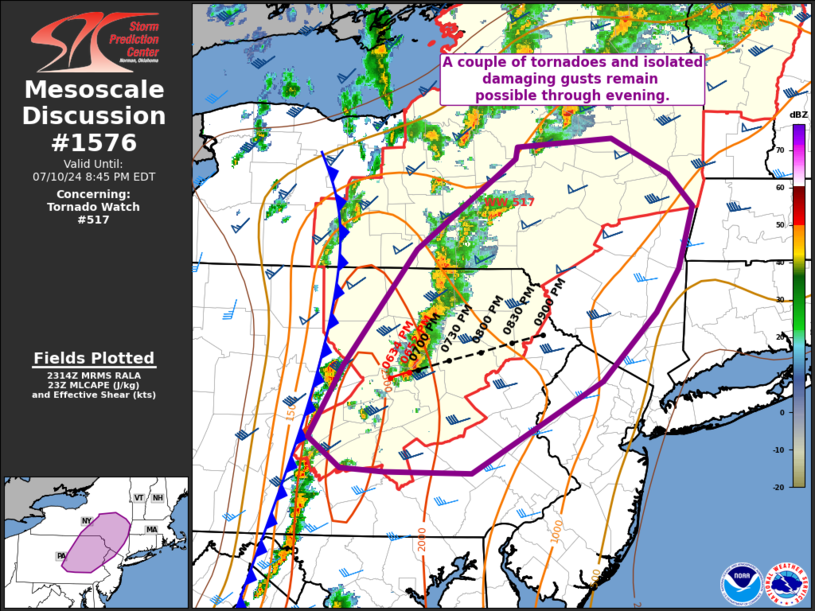
Areas affected...portions of southern NY...eastern PA...and northern
NJ
Concerning...Tornado Watch 517...
Valid 102317Z - 110045Z
The severe weather threat for Tornado Watch 517 continues.
SUMMARY...Severe thunderstorms will continue to pose a risk for a
couple of tornadoes and isolated damaging gusts the next couple of
hours across Tornado Watch 517.
DISCUSSION...A mix of discrete supercells and line segments are
ongoing this evening across parts of southern/central NY into
central/eastern PA. This activity should continue to track northeast
at around 35 kt over the next few hours, with additional storm
development possible a bit further west along the synoptic cold
front. A moist and unstable airmass with favorable vertical shear is
in place and will aid in continued severe potential in the short
term across Tornado Watch 517.
A gradual decrease in instability and more favorable vertical shear
is noted with eastern extent into parts of southern NY, far eastern
PA, NJ and southern New England. Storm intensity is expected to
gradually wane with eastward extent through the evening as the
boundary-layer nocturnally stabilizes. A downstream watch is not
expected at this time. However, if needed, local watch extensions
may be considered for parts of WFOs BGM and ALY as convection nears
the watch boundary by 01z.
..Leitman.. 07/10/2024
...Please see www.spc.noaa.gov for graphic product...
ATTN...WFO...OKX...ALY...PHI...BGM...CTP...
LAT...LON 42167655 42927543 43027540 43107433 42797367 42517340
41987357 41627384 41047445 40267592 40267690 40307738
40567774 41177735 42167655
|
|
Top/All Mesoscale Discussions/Forecast Products/Home
|
|


 @NWSSPC