 Note:
The expiration time in the watch graphic is amended if the watch is
replaced, cancelled or extended.
Note:
Note:
The expiration time in the watch graphic is amended if the watch is
replaced, cancelled or extended.
Note: Click for
Watch Status Reports.
SEL4
URGENT - IMMEDIATE BROADCAST REQUESTED
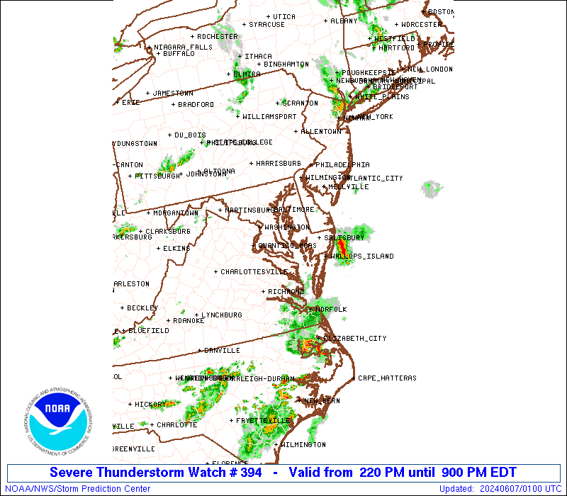
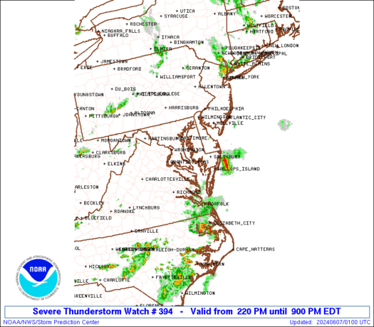
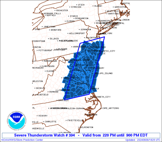
Severe Thunderstorm Watch Number 394
NWS Storm Prediction Center Norman OK
220 PM EDT Thu Jun 6 2024
The NWS Storm Prediction Center has issued a
* Severe Thunderstorm Watch for portions of
District Of Columbia
Delaware
Central and Eastern Maryland
Southern half of New Jersey
Southeast Pennsylvania
Eastern and Southern Virginia
Coastal Waters
* Effective this Thursday afternoon and evening from 220 PM until
900 PM EDT.
* Primary threats include...
Scattered damaging wind gusts to 65 mph possible
SUMMARY...Scattered thunderstorms will likely continue to develop
through the afternoon into several broken bands of strong to severe
thunderstorms. The stronger thunderstorms will be capable of strong
to severe gusts (50-65 mph) capable of wind damage. This activity
will likely push east of the Atlantic Seaboard by mid to late
evening with the severe risk diminishing from west to east across
the Watch area.
The severe thunderstorm watch area is approximately along and 65
statute miles east and west of a line from 5 miles northeast of
Trenton NJ to 35 miles east southeast of South Hill VA. For a
complete depiction of the watch see the associated watch outline
update (WOUS64 KWNS WOU4).
PRECAUTIONARY/PREPAREDNESS ACTIONS...
REMEMBER...A Severe Thunderstorm Watch means conditions are
favorable for severe thunderstorms in and close to the watch area.
Persons in these areas should be on the lookout for threatening
weather conditions and listen for later statements and possible
warnings. Severe thunderstorms can and occasionally do produce
tornadoes.
&&
AVIATION...A few severe thunderstorms with hail surface and aloft to
1 inch. Extreme turbulence and surface wind gusts to 55 knots. A few
cumulonimbi with maximum tops to 400. Mean storm motion vector
27025.
...Smith
 Note:
The Aviation Watch (SAW) product is an approximation to the watch area.
The actual watch is depicted by the shaded areas.
Note:
The Aviation Watch (SAW) product is an approximation to the watch area.
The actual watch is depicted by the shaded areas.
SAW4
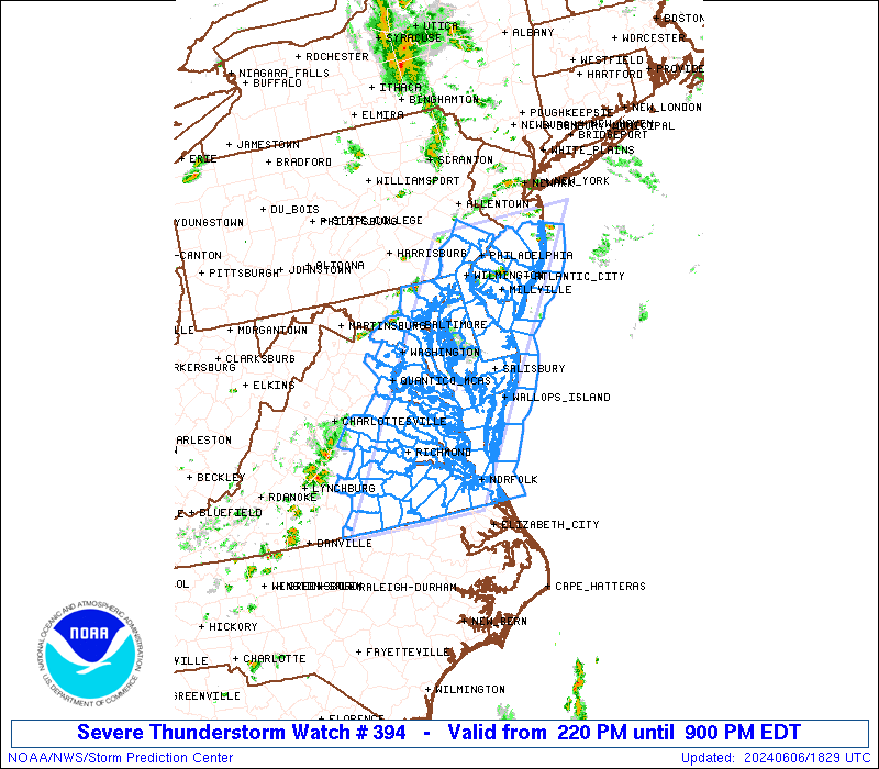
WW 394 SEVERE TSTM DC DE MD NJ PA VA CW 061820Z - 070100Z
AXIS..65 STATUTE MILES EAST AND WEST OF LINE..
5NE TTN/TRENTON NJ/ - 35ESE AVC/SOUTH HILL VA/
..AVIATION COORDS.. 55NM E/W /34NNW CYN - 61S RIC/
HAIL SURFACE AND ALOFT..1 INCH. WIND GUSTS..55 KNOTS.
MAX TOPS TO 400. MEAN STORM MOTION VECTOR 27025.
LAT...LON 40327351 36497630 36497864 40327598
THIS IS AN APPROXIMATION TO THE WATCH AREA. FOR A
COMPLETE DEPICTION OF THE WATCH SEE WOUS64 KWNS
FOR WOU4.
Watch 394 Status Report Messages:
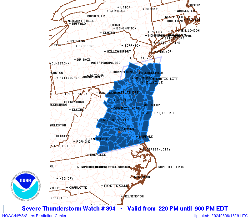
STATUS REPORT #2 ON WW 394
VALID 062335Z - 070040Z
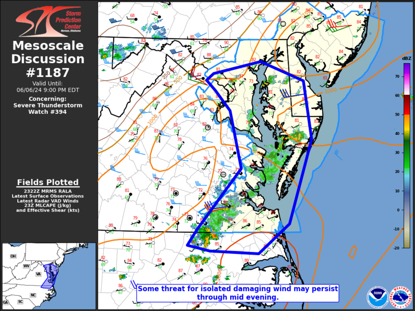
SEVERE WEATHER THREAT CONTINUES RIGHT OF A LINE FROM 10 SW RZZ TO
20 ESE RIC TO 15 WSW NHK TO 45 WSW DCA.
FOR ADDITIONAL INFORMATION SEE MESOSCALE DISCUSSION 1187
..DEAN..06/06/24
ATTN...WFO...LWX...PHI...AKQ...
&&
STATUS REPORT FOR WS 394
SEVERE WEATHER THREAT CONTINUES FOR THE FOLLOWING AREAS
DEC001-003-005-070040-
DE
. DELAWARE COUNTIES INCLUDED ARE
KENT NEW CASTLE SUSSEX
$$
DCC001-070040-
DC
. DISTRICT OF COLUMBIA COUNTIES INCLUDED ARE
DISTRICT OF COLUMBIA
$$
MDC003-005-009-011-015-017-019-025-027-029-031-033-035-037-039-
041-045-047-510-070040-
MD
. MARYLAND COUNTIES INCLUDED ARE
ANNE ARUNDEL BALTIMORE CALVERT
CAROLINE CECIL CHARLES
DORCHESTER HARFORD HOWARD
KENT MONTGOMERY PRINCE GEORGES
QUEEN ANNE'S ST. MARYS SOMERSET
TALBOT WICOMICO WORCESTER
MARYLAND INDEPENDENT CITIES INCLUDED ARE
BALTIMORE CITY
$$
NJC001-005-007-009-011-015-029-033-070040-
NJ
. NEW JERSEY COUNTIES INCLUDED ARE
ATLANTIC BURLINGTON CAMDEN
CAPE MAY CUMBERLAND GLOUCESTER
OCEAN SALEM
$$
PAC029-045-091-101-070040-
PA
. PENNSYLVANIA COUNTIES INCLUDED ARE
CHESTER DELAWARE MONTGOMERY
PHILADELPHIA
$$
VAC001-013-059-073-093-095-103-115-119-131-133-153-175-181-199-
510-550-600-610-620-650-683-685-700-710-735-740-800-810-830-
070040-
VA
. VIRGINIA COUNTIES INCLUDED ARE
ACCOMACK ARLINGTON FAIRFAX
GLOUCESTER ISLE OF WIGHT JAMES CITY
LANCASTER MATHEWS MIDDLESEX
NORTHAMPTON NORTHUMBERLAND PRINCE WILLIAM
SOUTHAMPTON SURRY YORK
VIRGINIA INDEPENDENT CITIES INCLUDED ARE
ALEXANDRIA CHESAPEAKE FAIRFAX
FALLS CHURCH FRANKLIN HAMPTON
MANASSAS MANASSAS PARK NEWPORT NEWS
NORFOLK POQUOSON PORTSMOUTH
SUFFOLK VIRGINIA BEACH WILLIAMSBURG
$$
ANZ430-431-451-452-453-454-455-530-531-532-533-534-535-537-538-
539-540-541-542-543-630-631-632-634-635-636-637-638-650-652-654-
656-070040-
CW
. ADJACENT COASTAL WATERS INCLUDED ARE
DELAWARE BAY WATERS NORTH OF EAST POINT NJ TO SLAUGHTER BEACH DE
DELAWARE BAY WATERS SOUTH OF EAST POINT NJ TO SLAUGHTER BEACH DE
COASTAL WATERS FROM MANASQUAN INLET TO LITTLE EGG INLET NJ OUT 20
NM
COASTAL WATERS FROM LITTLE EGG INLET TO GREAT EGG INLET NJ OUT 20
NM
COASTAL WATERS FROM GREAT EGG INLET TO CAPE MAY NJ OUT 20 NM
COASTAL WATERS FROM CAPE MAY NJ TO CAPE HENLOPEN DE OUT 20 NM
COASTAL WATERS FROM CAPE HENLOPEN TO FENWICK ISLAND DE OUT 20 NM
CHESAPEAKE BAY NORTH OF POOLES ISLAND MD
CHESAPEAKE BAY FROM POOLES ISLAND TO SANDY POINT MD
CHESAPEAKE BAY FROM SANDY POINT TO NORTH BEACH MD
CHESAPEAKE BAY FROM NORTH BEACH TO DRUM POINT MD
CHESAPEAKE BAY FROM DRUM POINT MD TO SMITH POINT VA
TIDAL POTOMAC FROM KEY BRIDGE TO INDIAN HEAD MD
TIDAL POTOMAC FROM COBB ISLAND MD TO SMITH POINT VA
PATAPSCO RIVER INCLUDING BALTIMORE HARBOR
CHESTER RIVER TO QUEENSTOWN MD
EASTERN BAY
CHOPTANK RIVER TO CAMBRIDGE MD AND THE LITTLE CHOPTANK RIVER
PATUXENT RIVER TO BROOMES ISLAND MD
TANGIER SOUND AND THE INLAND WATERS SURROUNDING BLOODSWORTH
ISLAND
CHESAPEAKE BAY FROM SMITH POINT TO WINDMILL POINT VA
CHESAPEAKE BAY FROM WINDMILL POINT TO NEW POINT COMFORT VA
CHESAPEAKE BAY FROM NEW POINT COMFORT TO LITTLE CREEK VA
CHESAPEAKE BAY FROM LITTLE CREEK VA TO CAPE HENRY VA INCLUDING
THE CHESAPEAKE BAY BRIDGE TUNNEL
RAPPAHANNOCK RIVER FROM URBANNA TO WINDMILL POINT
YORK RIVER
JAMES RIVER FROM JAMESTOWN TO THE JAMES RIVER BRIDGE
JAMES RIVER FROM JAMES RIVER BRIDGE TO HAMPTON ROADS
BRIDGE-TUNNEL
COASTAL WATERS FROM FENWICK ISLAND DE TO CHINCOTEAGUE VA OUT 20
NM
COASTAL WATERS FROM CHINCOTEAGUE TO PARRAMORE ISLAND VA OUT 20 NM
COASTAL WATERS FROM PARRAMORE ISLAND TO CAPE CHARLES LIGHT VA OUT
20 NM
COASTAL WATERS FROM CAPE CHARLES LIGHT TO VIRGINIA-NORTH CAROLINA
BORDER OUT TO 20 NM
$$
THE WATCH STATUS MESSAGE IS FOR GUIDANCE PURPOSES ONLY. PLEASE
REFER TO WATCH COUNTY NOTIFICATION STATEMENTS FOR OFFICIAL
INFORMATION ON COUNTIES...INDEPENDENT CITIES AND MARINE ZONES
CLEARED FROM SEVERE THUNDERSTORM AND TORNADO WATCHES.
$$
STATUS REPORT #1 ON WW 394
VALID 062140Z - 062240Z
THE SEVERE WEATHER THREAT CONTINUES ACROSS THE ENTIRE WATCH AREA.
FOR ADDITIONAL INFORMATION SEE MESOSCALE DISCUSSION 1185
..DEAN..06/06/24
ATTN...WFO...LWX...PHI...AKQ...
&&
STATUS REPORT FOR WS 394
SEVERE WEATHER THREAT CONTINUES FOR THE FOLLOWING AREAS
DEC001-003-005-062240-
DE
. DELAWARE COUNTIES INCLUDED ARE
KENT NEW CASTLE SUSSEX
$$
DCC001-062240-
DC
. DISTRICT OF COLUMBIA COUNTIES INCLUDED ARE
DISTRICT OF COLUMBIA
$$
MDC003-005-009-011-015-017-019-025-027-029-031-033-035-037-039-
041-045-047-510-062240-
MD
. MARYLAND COUNTIES INCLUDED ARE
ANNE ARUNDEL BALTIMORE CALVERT
CAROLINE CECIL CHARLES
DORCHESTER HARFORD HOWARD
KENT MONTGOMERY PRINCE GEORGES
QUEEN ANNE'S ST. MARYS SOMERSET
TALBOT WICOMICO WORCESTER
MARYLAND INDEPENDENT CITIES INCLUDED ARE
BALTIMORE CITY
$$
NJC001-005-007-009-011-015-029-033-062240-
NJ
. NEW JERSEY COUNTIES INCLUDED ARE
ATLANTIC BURLINGTON CAMDEN
CAPE MAY CUMBERLAND GLOUCESTER
OCEAN SALEM
$$
PAC029-045-091-101-062240-
PA
. PENNSYLVANIA COUNTIES INCLUDED ARE
CHESTER DELAWARE MONTGOMERY
PHILADELPHIA
$$
VAC001-007-013-025-033-036-041-053-057-059-073-081-085-087-093-
095-097-099-101-103-111-115-117-119-127-131-133-135-149-153-159-
175-177-179-181-183-193-199-510-550-570-595-600-610-620-630-650-
670-683-685-700-710-730-735-740-760-800-810-830-062240-
VA
. VIRGINIA COUNTIES INCLUDED ARE
ACCOMACK AMELIA ARLINGTON
BRUNSWICK CAROLINE CHARLES CITY
CHESTERFIELD DINWIDDIE ESSEX
FAIRFAX GLOUCESTER GREENSVILLE
HANOVER HENRICO ISLE OF WIGHT
JAMES CITY KING AND QUEEN KING GEORGE
KING WILLIAM LANCASTER LUNENBURG
MATHEWS MECKLENBURG MIDDLESEX
NEW KENT NORTHAMPTON NORTHUMBERLAND
NOTTOWAY PRINCE GEORGE PRINCE WILLIAM
RICHMOND SOUTHAMPTON SPOTSYLVANIA
STAFFORD SURRY SUSSEX
WESTMORELAND YORK
VIRGINIA INDEPENDENT CITIES INCLUDED ARE
ALEXANDRIA CHESAPEAKE COLONIAL HEIGHTS
EMPORIA FAIRFAX FALLS CHURCH
FRANKLIN FREDERICKSBURG HAMPTON
HOPEWELL MANASSAS MANASSAS PARK
NEWPORT NEWS NORFOLK PETERSBURG
POQUOSON PORTSMOUTH RICHMOND
SUFFOLK VIRGINIA BEACH WILLIAMSBURG
$$
ANZ430-431-451-452-453-454-455-530-531-532-533-534-535-536-537-
538-539-540-541-542-543-630-631-632-634-635-636-637-638-650-652-
654-656-062240-
CW
. ADJACENT COASTAL WATERS INCLUDED ARE
DELAWARE BAY WATERS NORTH OF EAST POINT NJ TO SLAUGHTER BEACH DE
DELAWARE BAY WATERS SOUTH OF EAST POINT NJ TO SLAUGHTER BEACH DE
COASTAL WATERS FROM MANASQUAN INLET TO LITTLE EGG INLET NJ OUT 20
NM
COASTAL WATERS FROM LITTLE EGG INLET TO GREAT EGG INLET NJ OUT 20
NM
COASTAL WATERS FROM GREAT EGG INLET TO CAPE MAY NJ OUT 20 NM
COASTAL WATERS FROM CAPE MAY NJ TO CAPE HENLOPEN DE OUT 20 NM
COASTAL WATERS FROM CAPE HENLOPEN TO FENWICK ISLAND DE OUT 20 NM
CHESAPEAKE BAY NORTH OF POOLES ISLAND MD
CHESAPEAKE BAY FROM POOLES ISLAND TO SANDY POINT MD
CHESAPEAKE BAY FROM SANDY POINT TO NORTH BEACH MD
CHESAPEAKE BAY FROM NORTH BEACH TO DRUM POINT MD
CHESAPEAKE BAY FROM DRUM POINT MD TO SMITH POINT VA
TIDAL POTOMAC FROM KEY BRIDGE TO INDIAN HEAD MD
TIDAL POTOMAC FROM INDIAN HEAD TO COBB ISLAND MD
TIDAL POTOMAC FROM COBB ISLAND MD TO SMITH POINT VA
PATAPSCO RIVER INCLUDING BALTIMORE HARBOR
CHESTER RIVER TO QUEENSTOWN MD
EASTERN BAY
CHOPTANK RIVER TO CAMBRIDGE MD AND THE LITTLE CHOPTANK RIVER
PATUXENT RIVER TO BROOMES ISLAND MD
TANGIER SOUND AND THE INLAND WATERS SURROUNDING BLOODSWORTH
ISLAND
CHESAPEAKE BAY FROM SMITH POINT TO WINDMILL POINT VA
CHESAPEAKE BAY FROM WINDMILL POINT TO NEW POINT COMFORT VA
CHESAPEAKE BAY FROM NEW POINT COMFORT TO LITTLE CREEK VA
CHESAPEAKE BAY FROM LITTLE CREEK VA TO CAPE HENRY VA INCLUDING
THE CHESAPEAKE BAY BRIDGE TUNNEL
RAPPAHANNOCK RIVER FROM URBANNA TO WINDMILL POINT
YORK RIVER
JAMES RIVER FROM JAMESTOWN TO THE JAMES RIVER BRIDGE
JAMES RIVER FROM JAMES RIVER BRIDGE TO HAMPTON ROADS
BRIDGE-TUNNEL
COASTAL WATERS FROM FENWICK ISLAND DE TO CHINCOTEAGUE VA OUT 20
NM
COASTAL WATERS FROM CHINCOTEAGUE TO PARRAMORE ISLAND VA OUT 20 NM
COASTAL WATERS FROM PARRAMORE ISLAND TO CAPE CHARLES LIGHT VA OUT
20 NM
COASTAL WATERS FROM CAPE CHARLES LIGHT TO VIRGINIA-NORTH CAROLINA
BORDER OUT TO 20 NM
$$
THE WATCH STATUS MESSAGE IS FOR GUIDANCE PURPOSES ONLY. PLEASE
REFER TO WATCH COUNTY NOTIFICATION STATEMENTS FOR OFFICIAL
INFORMATION ON COUNTIES...INDEPENDENT CITIES AND MARINE ZONES
CLEARED FROM SEVERE THUNDERSTORM AND TORNADO WATCHES.
$$
Note:
Click for Complete Product Text.
Tornadoes
Probability of 2 or more tornadoes
|
Low (<5%)
|
Probability of 1 or more strong (EF2-EF5) tornadoes
|
Low (<2%)
|
Wind
Probability of 10 or more severe wind events
|
Mod (50%)
|
Probability of 1 or more wind events > 65 knots
|
Low (20%)
|
Hail
Probability of 10 or more severe hail events
|
Low (<5%)
|
Probability of 1 or more hailstones > 2 inches
|
Low (<5%)
|
Combined Severe Hail/Wind
Probability of 6 or more combined severe hail/wind events
|
High (70%)
|
For each watch, probabilities for particular events inside the watch
(listed above in each table) are determined by the issuing forecaster.
The "Low" category contains probability values ranging from less than 2%
to 20% (EF2-EF5 tornadoes), less than 5% to 20% (all other probabilities),
"Moderate" from 30% to 60%, and "High" from 70% to greater than 95%.
High values are bolded and lighter in color to provide awareness of
an increased threat for a particular event.


 @NWSSPC