Note:
The expiration time in the watch graphic is amended if the watch is
replaced, cancelled or extended.
Note:
Note:
The expiration time in the watch graphic is amended if the watch is
replaced, cancelled or extended.
Note: Click for
Watch Status Reports.
SEL3
URGENT - IMMEDIATE BROADCAST REQUESTED
Severe Thunderstorm Watch Number 393
NWS Storm Prediction Center Norman OK
915 PM CDT Tue Jun 4 2024
The NWS Storm Prediction Center has issued a
* Severe Thunderstorm Watch for portions of
Southeast Kansas
Southwest Missouri
Eastern Oklahoma
* Effective this Tuesday night and Wednesday morning from 915 PM
until 300 AM CDT.
* Primary threats include...
Scattered damaging wind gusts to 70 mph likely
Scattered large hail and isolated very large hail events to 2
inches in diameter possible
SUMMARY...Multiple clusters and lines of thunderstorms will track
east-southeastward across the watch area through the overnight
hours, posing a risk of damaging winds gusts and large hail.
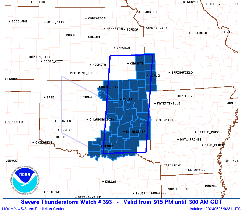
The severe thunderstorm watch area is approximately along and 60
statute miles east and west of a line from 25 miles north northeast
of Chanute KS to 60 miles south of Mcalester OK. For a complete
depiction of the watch see the associated watch outline update
(WOUS64 KWNS WOU3).
PRECAUTIONARY/PREPAREDNESS ACTIONS...
REMEMBER...A Severe Thunderstorm Watch means conditions are
favorable for severe thunderstorms in and close to the watch area.
Persons in these areas should be on the lookout for threatening
weather conditions and listen for later statements and possible
warnings. Severe thunderstorms can and occasionally do produce
tornadoes.
&&
OTHER WATCH INFORMATION...CONTINUE...WW 392...
AVIATION...A few severe thunderstorms with hail surface and aloft to
2 inches. Extreme turbulence and surface wind gusts to 60 knots. A
few cumulonimbi with maximum tops to 500. Mean storm motion vector
28030.
...Hart

   SEL3

   URGENT - IMMEDIATE BROADCAST REQUESTED
   Severe Thunderstorm Watch Number 393
   NWS Storm Prediction Center Norman OK
   915 PM CDT Tue Jun 4 2024

   The NWS Storm Prediction Center has issued a

   * Severe Thunderstorm Watch for portions of
     Southeast Kansas
     Southwest Missouri
     Eastern Oklahoma

   * Effective this Tuesday night and Wednesday morning from 915 PM
     until 300 AM CDT.

   * Primary threats include...
     Scattered damaging wind gusts to 70 mph likely
     Scattered large hail and isolated very large hail events to 2
       inches in diameter possible

   SUMMARY...Multiple clusters and lines of thunderstorms will track
   east-southeastward across the watch area through the overnight
   hours, posing a risk of damaging winds gusts and large hail.

   The severe thunderstorm watch area is approximately along and 60
   statute miles east and west of a line from 25 miles north northeast
   of Chanute KS to 60 miles south of Mcalester OK. For a complete
   depiction of the watch see the associated watch outline update
   (WOUS64 KWNS WOU3).

   PRECAUTIONARY/PREPAREDNESS ACTIONS...

   REMEMBER...A Severe Thunderstorm Watch means conditions are
   favorable for severe thunderstorms in and close to the watch area.
   Persons in these areas should be on the lookout for threatening
   weather conditions and listen for later statements and possible
   warnings. Severe thunderstorms can and occasionally do produce
   tornadoes.

   &&

   OTHER WATCH INFORMATION...CONTINUE...WW 392...

   AVIATION...A few severe thunderstorms with hail surface and aloft to
   2 inches. Extreme turbulence and surface wind gusts to 60 knots. A
   few cumulonimbi with maximum tops to 500. Mean storm motion vector
   28030.

   ...Hart
 Note:
The Aviation Watch (SAW) product is an approximation to the watch area.
The actual watch is depicted by the shaded areas.
Note:
The Aviation Watch (SAW) product is an approximation to the watch area.
The actual watch is depicted by the shaded areas.
   SAW3
   WW 393 SEVERE TSTM KS MO OK 050215Z - 050800Z
   AXIS..60 STATUTE MILES EAST AND WEST OF LINE..
   25NNE CNU/CHANUTE KS/ - 60S MLC/MCALESTER OK/
   ..AVIATION COORDS.. 50NM E/W /42WSW BUM - 50S MLC/
   HAIL SURFACE AND ALOFT..2 INCHES. WIND GUSTS..60 KNOTS.
   MAX TOPS TO 500. MEAN STORM MOTION VECTOR 28030.

   LAT...LON 38009420 34009473 34009683 38009641

   THIS IS AN APPROXIMATION TO THE WATCH AREA.  FOR A
   COMPLETE DEPICTION OF THE WATCH SEE WOUS64 KWNS
   FOR WOU3.
Watch 393 Status Report Messages:
STATUS REPORT #4 ON WW 393

VALID 050645Z - 050740Z

SEVERE WEATHER THREAT CONTINUES RIGHT OF A LINE FROM 25 NNE ADM
TO 40 N PRX TO 20 NW FYV.

..GRAMS..06/05/24

ATTN...WFO...SGF...TSA...OUN...

&&

STATUS REPORT FOR WS 393

SEVERE WEATHER THREAT CONTINUES FOR THE FOLLOWING AREAS

OKC013-019-023-069-079-085-095-099-050740-

OK
.    OKLAHOMA COUNTIES INCLUDED ARE

BRYAN		     CARTER		 CHOCTAW
JOHNSTON	     LE FLORE		 LOVE
MARSHALL	     MURRAY
$$


THE WATCH STATUS MESSAGE IS FOR GUIDANCE PURPOSES ONLY.  PLEASE
REFER TO WATCH COUNTY NOTIFICATION STATEMENTS FOR OFFICIAL
INFORMATION ON COUNTIES...INDEPENDENT CITIES AND MARINE ZONES
CLEARED FROM SEVERE THUNDERSTORM AND TORNADO WATCHES.
$$

STATUS REPORT #3 ON WW 393

VALID 050540Z - 050640Z

SEVERE WEATHER THREAT CONTINUES RIGHT OF A LINE FROM 20 NE CQB TO
5 NW GMJ TO 40 NNE JLN.

FOR ADDITIONAL INFORMATION SEE MESOSCALE DISCUSSION 1171.

..GRAMS..06/05/24

ATTN...WFO...SGF...TSA...OUN...

&&

STATUS REPORT FOR WS 393

SEVERE WEATHER THREAT CONTINUES FOR THE FOLLOWING AREAS

MOC097-119-145-050640-

MO
.    MISSOURI COUNTIES INCLUDED ARE

JASPER		     MCDONALD		 NEWTON
$$


OKC001-005-013-019-021-023-029-037-041-061-063-069-077-079-085-
091-095-097-099-101-107-111-121-123-127-135-145-050640-

OK
.    OKLAHOMA COUNTIES INCLUDED ARE

ADAIR		     ATOKA		 BRYAN
CARTER		     CHEROKEE		 CHOCTAW
COAL		     CREEK		 DELAWARE
HASKELL 	     HUGHES		 JOHNSTON
LATIMER 	     LE FLORE		 LOVE
MCINTOSH	     MARSHALL		 MAYES
MURRAY		     MUSKOGEE		 OKFUSKEE
OKMULGEE	     PITTSBURG		 PONTOTOC
PUSHMATAHA	     SEQUOYAH		 WAGONER
$$


THE WATCH STATUS MESSAGE IS FOR GUIDANCE PURPOSES ONLY.  PLEASE
REFER TO WATCH COUNTY NOTIFICATION STATEMENTS FOR OFFICIAL
INFORMATION ON COUNTIES...INDEPENDENT CITIES AND MARINE ZONES
CLEARED FROM SEVERE THUNDERSTORM AND TORNADO WATCHES.
$$

STATUS REPORT #2 ON WW 393

VALID 050425Z - 050540Z

SEVERE WEATHER THREAT CONTINUES RIGHT OF A LINE FROM 25 SSE PNC
TO 15 NNW TUL TO 35 WSW JLN TO 55 SSE OJC.

..HART..06/05/24

ATTN...WFO...SGF...TSA...OUN...

&&

STATUS REPORT FOR WS 393

SEVERE WEATHER THREAT CONTINUES FOR THE FOLLOWING AREAS

KSC021-037-050540-

KS
.    KANSAS COUNTIES INCLUDED ARE

CHEROKEE	     CRAWFORD
$$


MOC011-097-119-145-217-050540-

MO
.    MISSOURI COUNTIES INCLUDED ARE

BARTON		     JASPER		 MCDONALD
NEWTON		     VERNON
$$


OKC001-005-013-019-021-023-029-035-037-041-061-063-069-077-079-
085-091-095-097-099-101-107-111-113-115-117-121-123-127-131-135-
143-145-050540-

OK
.    OKLAHOMA COUNTIES INCLUDED ARE

ADAIR		     ATOKA		 BRYAN
CARTER		     CHEROKEE		 CHOCTAW
COAL		     CRAIG		 CREEK
DELAWARE	     HASKELL		 HUGHES
JOHNSTON	     LATIMER		 LE FLORE
LOVE		     MCINTOSH		 MARSHALL
MAYES		     MURRAY		 MUSKOGEE
OKFUSKEE	     OKMULGEE		 OSAGE
OTTAWA		     PAWNEE		 PITTSBURG
PONTOTOC	     PUSHMATAHA 	 ROGERS
SEQUOYAH	     TULSA		 WAGONER
$$


THE WATCH STATUS MESSAGE IS FOR GUIDANCE PURPOSES ONLY.  PLEASE
REFER TO WATCH COUNTY NOTIFICATION STATEMENTS FOR OFFICIAL
INFORMATION ON COUNTIES...INDEPENDENT CITIES AND MARINE ZONES
CLEARED FROM SEVERE THUNDERSTORM AND TORNADO WATCHES.
$$

STATUS REPORT #1 ON WW 393

VALID 050330Z - 050440Z

THE SEVERE WEATHER THREAT CONTINUES ACROSS THE ENTIRE WATCH AREA.

..BROYLES..06/05/24

ATTN...WFO...SGF...TSA...OUN...

&&

STATUS REPORT FOR WS 393

SEVERE WEATHER THREAT CONTINUES FOR THE FOLLOWING AREAS

KSC011-021-037-050440-

KS
.    KANSAS COUNTIES INCLUDED ARE

BOURBON 	     CHEROKEE		 CRAWFORD
$$


MOC011-097-119-145-217-050440-

MO
.    MISSOURI COUNTIES INCLUDED ARE

BARTON		     JASPER		 MCDONALD
NEWTON		     VERNON
$$


OKC001-005-013-019-021-023-029-035-037-041-061-063-069-077-079-
085-091-095-097-099-101-105-107-111-113-115-117-121-123-127-131-
135-143-145-147-050440-

OK
.    OKLAHOMA COUNTIES INCLUDED ARE

ADAIR		     ATOKA		 BRYAN
CARTER		     CHEROKEE		 CHOCTAW
COAL		     CRAIG		 CREEK
DELAWARE	     HASKELL		 HUGHES
JOHNSTON	     LATIMER		 LE FLORE
LOVE		     MCINTOSH		 MARSHALL
MAYES		     MURRAY		 MUSKOGEE
NOWATA		     OKFUSKEE		 OKMULGEE
OSAGE		     OTTAWA		 PAWNEE
PITTSBURG	     PONTOTOC		 PUSHMATAHA
ROGERS		     SEQUOYAH		 TULSA
WAGONER 	     WASHINGTON
$$


THE WATCH STATUS MESSAGE IS FOR GUIDANCE PURPOSES ONLY.  PLEASE
REFER TO WATCH COUNTY NOTIFICATION STATEMENTS FOR OFFICIAL
INFORMATION ON COUNTIES...INDEPENDENT CITIES AND MARINE ZONES
CLEARED FROM SEVERE THUNDERSTORM AND TORNADO WATCHES.
$$
Note:
Click for Complete Product Text.
Tornadoes
Probability of 2 or more tornadoes
|
Low (10%)
|
Probability of 1 or more strong (EF2-EF5) tornadoes
|
Low (<2%)
|
Wind
Probability of 10 or more severe wind events
|
Mod (60%)
|
Probability of 1 or more wind events > 65 knots
|
Low (10%)
|
Hail
Probability of 10 or more severe hail events
|
Mod (40%)
|
Probability of 1 or more hailstones > 2 inches
|
Mod (40%)
|
Combined Severe Hail/Wind
Probability of 6 or more combined severe hail/wind events
|
High (90%)
|
For each watch, probabilities for particular events inside the watch
(listed above in each table) are determined by the issuing forecaster.
The "Low" category contains probability values ranging from less than 2%
to 20% (EF2-EF5 tornadoes), less than 5% to 20% (all other probabilities),
"Moderate" from 30% to 60%, and "High" from 70% to greater than 95%.
High values are bolded and lighter in color to provide awareness of
an increased threat for a particular event.


 @NWSSPC