|
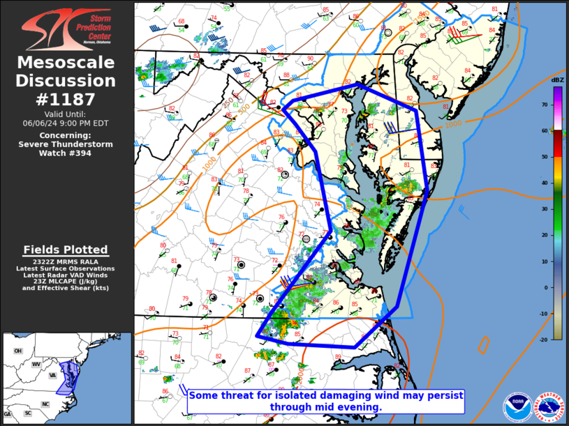
| Mesoscale Discussion 1187 |
|
< Previous MD Next MD >
|
|
   Mesoscale Discussion 1187
   NWS Storm Prediction Center Norman OK
   0625 PM CDT Thu Jun 06 2024

   Areas affected...Southern Mid Atlantic vicinity

   Concerning...Severe Thunderstorm Watch 394...

   Valid 062325Z - 070100Z

   The severe weather threat for Severe Thunderstorm Watch 394
   continues.

   SUMMARY...Some threat for isolated damaging wind may persist through
   mid evening.

   DISCUSSION...A loosely organized storm cluster is moving eastward
   near the VA/NC border this evening. The downstream environment
   remains warm, moist, and moderately unstable, and isolated damaging
   winds cannot be ruled out before this cluster eventually moves
   offshore.

   Farther north, some modest intensification has been noted with storm
   clusters across eastern MD. The KDOX VWP depicts modestly enhanced
   westerly 1-3 km flow, which will support some damaging-wind
   potential with the ongoing storm clusters. An additional strong
   storm or two could develop this evening near a weak surface trough
   across northern MD. Later tonight, the severe threat should tend to
   diminish as ongoing storms move offshore and MLCINH generally begins
   to increase with time.

   ..Dean.. 06/06/2024

   ...Please see www.spc.noaa.gov for graphic product...

   ATTN...WFO...PHI...AKQ...LWX...RAH...

   LAT...LON   36697575 36207638 36237738 36337783 36597763 37597674
               38547698 38877730 39057748 39157733 39367634 39037544
               38077528 36697575
|
|
Top/All Mesoscale Discussions/Forecast Products/Home
|
|


 @NWSSPC