Note:
The expiration time in the watch graphic is amended if the watch is
replaced, cancelled or extended.
Note:
Note:
The expiration time in the watch graphic is amended if the watch is
replaced, cancelled or extended.
Note: Click for
Watch Status Reports.
SEL5
URGENT - IMMEDIATE BROADCAST REQUESTED
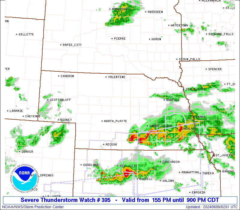
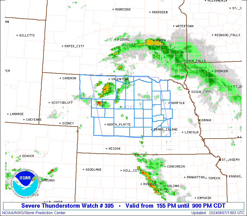
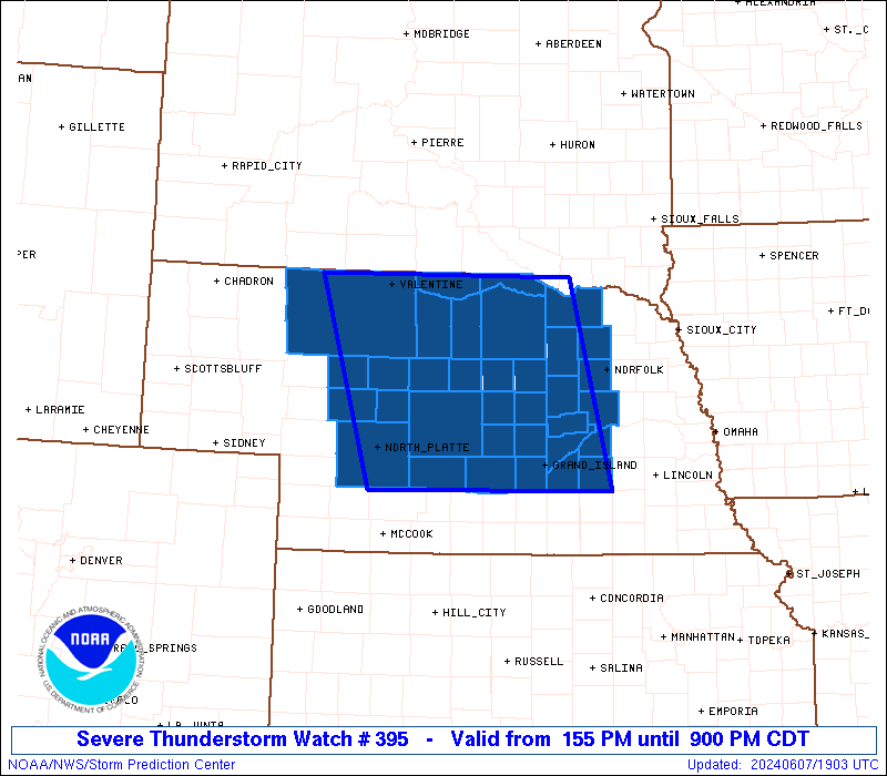
Severe Thunderstorm Watch Number 395
NWS Storm Prediction Center Norman OK
155 PM CDT Fri Jun 7 2024
The NWS Storm Prediction Center has issued a
* Severe Thunderstorm Watch for portions of
Northern and Central Nebraska
* Effective this Friday afternoon and evening from 155 PM until
900 PM CDT.
* Primary threats include...
Scattered damaging winds likely with isolated significant gusts
to 80 mph possible
Scattered large hail likely with isolated very large hail events
to 3 inches in diameter possible
A tornado or two possible
SUMMARY...Scattered severe thunderstorms are expected to develop and
increase through mid/late afternoon, initially across north-central
Nebraska. This includes the potential for supercells capable of very
large hail, and possibly some tornado risk. Over time, storms will
merge, with a broader complex of southeastward-moving storms likely
evolving regionally by early evening.
The severe thunderstorm watch area is approximately along and 90
statute miles east and west of a line from 30 miles north northeast
of Ainsworth NE to 5 miles west southwest of Kearney NE. For a
complete depiction of the watch see the associated watch outline
update (WOUS64 KWNS WOU5).
PRECAUTIONARY/PREPAREDNESS ACTIONS...
REMEMBER...A Severe Thunderstorm Watch means conditions are
favorable for severe thunderstorms in and close to the watch area.
Persons in these areas should be on the lookout for threatening
weather conditions and listen for later statements and possible
warnings. Severe thunderstorms can and occasionally do produce
tornadoes.
&&
AVIATION...A few severe thunderstorms with hail surface and aloft to
3 inches. Extreme turbulence and surface wind gusts to 70 knots. A
few cumulonimbi with maximum tops to 550. Mean storm motion vector
29035.
...Guyer

   SEL5

   URGENT - IMMEDIATE BROADCAST REQUESTED
   Severe Thunderstorm Watch Number 395
   NWS Storm Prediction Center Norman OK
   155 PM CDT Fri Jun 7 2024

   The NWS Storm Prediction Center has issued a

   * Severe Thunderstorm Watch for portions of
     Northern and Central Nebraska

   * Effective this Friday afternoon and evening from 155 PM until
     900 PM CDT.

   * Primary threats include...
     Scattered damaging winds likely with isolated significant gusts
       to 80 mph possible
     Scattered large hail likely with isolated very large hail events
       to 3 inches in diameter possible
     A tornado or two possible

   SUMMARY...Scattered severe thunderstorms are expected to develop and
   increase through mid/late afternoon, initially across north-central
   Nebraska. This includes the potential for supercells capable of very
   large hail, and possibly some tornado risk. Over time, storms will
   merge, with a broader complex of southeastward-moving storms likely
   evolving regionally by early evening.

   The severe thunderstorm watch area is approximately along and 90
   statute miles east and west of a line from 30 miles north northeast
   of Ainsworth NE to 5 miles west southwest of Kearney NE. For a
   complete depiction of the watch see the associated watch outline
   update (WOUS64 KWNS WOU5).

   PRECAUTIONARY/PREPAREDNESS ACTIONS...

   REMEMBER...A Severe Thunderstorm Watch means conditions are
   favorable for severe thunderstorms in and close to the watch area.
   Persons in these areas should be on the lookout for threatening
   weather conditions and listen for later statements and possible
   warnings. Severe thunderstorms can and occasionally do produce
   tornadoes.

   &&

   AVIATION...A few severe thunderstorms with hail surface and aloft to
   3 inches. Extreme turbulence and surface wind gusts to 70 knots. A
   few cumulonimbi with maximum tops to 550. Mean storm motion vector
   29035.

   ...Guyer
 Note:
The Aviation Watch (SAW) product is an approximation to the watch area.
The actual watch is depicted by the shaded areas.
Note:
The Aviation Watch (SAW) product is an approximation to the watch area.
The actual watch is depicted by the shaded areas.
   SAW5
   WW 395 SEVERE TSTM NE 071855Z - 080200Z
   AXIS..90 STATUTE MILES EAST AND WEST OF LINE..
   30NNE ANW/AINSWORTH NE/ - 5WSW EAR/KEARNEY NE/
   ..AVIATION COORDS.. 80NM E/W /27NNE ANW - 53SW OBH/
   HAIL SURFACE AND ALOFT..3 INCHES. WIND GUSTS..70 KNOTS.
   MAX TOPS TO 550. MEAN STORM MOTION VECTOR 29035.

   LAT...LON 42979797 40689737 40680081 42970153

   THIS IS AN APPROXIMATION TO THE WATCH AREA.  FOR A
   COMPLETE DEPICTION OF THE WATCH SEE WOUS64 KWNS
   FOR WOU5.
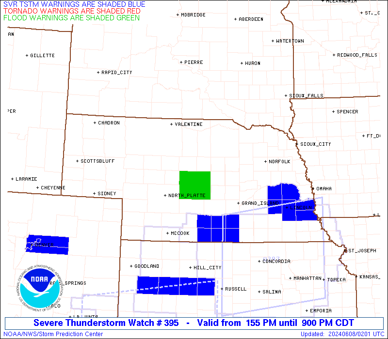
Watch 395 Status Report Messages:
STATUS REPORT #5 ON WW 395

VALID 080035Z - 080140Z

SEVERE WEATHER THREAT CONTINUES RIGHT OF A LINE FROM 25 NE IML TO
15 E BBW TO 15 NW OFK.

FOR ADDITIONAL INFORMATION SEE MESOSCALE DISCUSSION 1196

..THORNTON..06/08/24

ATTN...WFO...OAX...LBF...GID...

&&

STATUS REPORT FOR WS 395

SEVERE WEATHER THREAT CONTINUES FOR THE FOLLOWING AREAS

NEC011-019-041-047-063-077-079-081-085-093-119-121-125-141-143-
163-175-185-080140-

NE
.    NEBRASKA COUNTIES INCLUDED ARE

BOONE		     BUFFALO		 CUSTER
DAWSON		     FRONTIER		 GREELEY
HALL		     HAMILTON		 HAYES
HOWARD		     MADISON		 MERRICK
NANCE		     PLATTE		 POLK
SHERMAN 	     VALLEY		 YORK
$$


THE WATCH STATUS MESSAGE IS FOR GUIDANCE PURPOSES ONLY.  PLEASE
REFER TO WATCH COUNTY NOTIFICATION STATEMENTS FOR OFFICIAL
INFORMATION ON COUNTIES...INDEPENDENT CITIES AND MARINE ZONES
CLEARED FROM SEVERE THUNDERSTORM AND TORNADO WATCHES.
$$

STATUS REPORT #4 ON WW 395

VALID 072345Z - 080040Z

SEVERE WEATHER THREAT CONTINUES RIGHT OF A LINE FROM 40 WNW LBF
TO 25 NE LBF TO 20 SSW ANW TO 40 NNE ANW.

..THORNTON..06/07/24

ATTN...WFO...OAX...LBF...GID...

&&

STATUS REPORT FOR WS 395

SEVERE WEATHER THREAT CONTINUES FOR THE FOLLOWING AREAS

NEC003-009-011-015-017-019-041-047-063-071-077-079-081-085-089-
093-103-111-115-119-121-125-139-141-143-149-163-175-183-185-
080040-

NE
.    NEBRASKA COUNTIES INCLUDED ARE

ANTELOPE	     BLAINE		 BOONE
BOYD		     BROWN		 BUFFALO
CUSTER		     DAWSON		 FRONTIER
GARFIELD	     GREELEY		 HALL
HAMILTON	     HAYES		 HOLT
HOWARD		     KEYA PAHA		 LINCOLN
LOUP		     MADISON		 MERRICK
NANCE		     PIERCE		 PLATTE
POLK		     ROCK		 SHERMAN
VALLEY		     WHEELER		 YORK
$$


THE WATCH STATUS MESSAGE IS FOR GUIDANCE PURPOSES ONLY.  PLEASE
REFER TO WATCH COUNTY NOTIFICATION STATEMENTS FOR OFFICIAL
INFORMATION ON COUNTIES...INDEPENDENT CITIES AND MARINE ZONES
CLEARED FROM SEVERE THUNDERSTORM AND TORNADO WATCHES.
$$

STATUS REPORT #3 ON WW 395

VALID 072235Z - 072340Z

SEVERE WEATHER THREAT CONTINUES RIGHT OF A LINE FROM 40 SW MHN TO
35 ESE MHN TO 40 NNE ANW.

FOR ADDITIONAL INFORMATION SEE MESOSCALE DISCUSSION 1191

..THORNTON..06/07/24

ATTN...WFO...OAX...LBF...GID...

&&

STATUS REPORT FOR WS 395

SEVERE WEATHER THREAT CONTINUES FOR THE FOLLOWING AREAS

NEC003-009-011-015-017-019-041-047-063-071-077-079-081-085-089-
093-103-107-111-113-115-117-119-121-125-139-141-143-149-163-175-
183-185-072340-

NE
.    NEBRASKA COUNTIES INCLUDED ARE

ANTELOPE	     BLAINE		 BOONE
BOYD		     BROWN		 BUFFALO
CUSTER		     DAWSON		 FRONTIER
GARFIELD	     GREELEY		 HALL
HAMILTON	     HAYES		 HOLT
HOWARD		     KEYA PAHA		 KNOX
LINCOLN 	     LOGAN		 LOUP
MCPHERSON	     MADISON		 MERRICK
NANCE		     PIERCE		 PLATTE
POLK		     ROCK		 SHERMAN
VALLEY		     WHEELER		 YORK
$$


THE WATCH STATUS MESSAGE IS FOR GUIDANCE PURPOSES ONLY.  PLEASE
REFER TO WATCH COUNTY NOTIFICATION STATEMENTS FOR OFFICIAL
INFORMATION ON COUNTIES...INDEPENDENT CITIES AND MARINE ZONES
CLEARED FROM SEVERE THUNDERSTORM AND TORNADO WATCHES.
$$

STATUS REPORT #2 ON WW 395

VALID 072145Z - 072240Z

THE SEVERE WEATHER THREAT CONTINUES ACROSS THE ENTIRE WATCH AREA.

FOR ADDITIONAL INFORMATION SEE MESOSCALE DISCUSSION 1191

..THORNTON..06/07/24

ATTN...WFO...OAX...LBF...GID...

&&

STATUS REPORT FOR WS 395

SEVERE WEATHER THREAT CONTINUES FOR THE FOLLOWING AREAS

NEC003-009-011-015-017-019-031-041-047-063-071-077-079-081-085-
089-091-093-103-107-111-113-115-117-119-121-125-139-141-143-149-
163-171-175-183-185-072240-

NE
.    NEBRASKA COUNTIES INCLUDED ARE

ANTELOPE	     BLAINE		 BOONE
BOYD		     BROWN		 BUFFALO
CHERRY		     CUSTER		 DAWSON
FRONTIER	     GARFIELD		 GREELEY
HALL		     HAMILTON		 HAYES
HOLT		     HOOKER		 HOWARD
KEYA PAHA	     KNOX		 LINCOLN
LOGAN		     LOUP		 MCPHERSON
MADISON 	     MERRICK		 NANCE
PIERCE		     PLATTE		 POLK
ROCK		     SHERMAN		 THOMAS
VALLEY		     WHEELER		 YORK
$$


THE WATCH STATUS MESSAGE IS FOR GUIDANCE PURPOSES ONLY.  PLEASE
REFER TO WATCH COUNTY NOTIFICATION STATEMENTS FOR OFFICIAL
INFORMATION ON COUNTIES...INDEPENDENT CITIES AND MARINE ZONES
CLEARED FROM SEVERE THUNDERSTORM AND TORNADO WATCHES.
$$

STATUS REPORT #1 ON WW 395

VALID 072050Z - 072140Z

THE SEVERE WEATHER THREAT CONTINUES ACROSS THE ENTIRE WATCH AREA.

..KERR..06/07/24

ATTN...WFO...OAX...LBF...GID...

&&

STATUS REPORT FOR WS 395

SEVERE WEATHER THREAT CONTINUES FOR THE FOLLOWING AREAS

NEC003-009-011-015-017-019-031-041-047-071-077-079-081-089-091-
093-103-107-111-113-115-117-119-121-125-139-141-143-149-163-171-
175-183-185-072140-

NE
.    NEBRASKA COUNTIES INCLUDED ARE

ANTELOPE	     BLAINE		 BOONE
BOYD		     BROWN		 BUFFALO
CHERRY		     CUSTER		 DAWSON
GARFIELD	     GREELEY		 HALL
HAMILTON	     HOLT		 HOOKER
HOWARD		     KEYA PAHA		 KNOX
LINCOLN 	     LOGAN		 LOUP
MCPHERSON	     MADISON		 MERRICK
NANCE		     PIERCE		 PLATTE
POLK		     ROCK		 SHERMAN
THOMAS		     VALLEY		 WHEELER
YORK
$$


THE WATCH STATUS MESSAGE IS FOR GUIDANCE PURPOSES ONLY.  PLEASE
REFER TO WATCH COUNTY NOTIFICATION STATEMENTS FOR OFFICIAL
INFORMATION ON COUNTIES...INDEPENDENT CITIES AND MARINE ZONES
CLEARED FROM SEVERE THUNDERSTORM AND TORNADO WATCHES.
$$
Note:
Click for Complete Product Text.
Tornadoes
Probability of 2 or more tornadoes
|
Low (20%)
|
Probability of 1 or more strong (EF2-EF5) tornadoes
|
Low (10%)
|
Wind
Probability of 10 or more severe wind events
|
Mod (60%)
|
Probability of 1 or more wind events > 65 knots
|
Mod (50%)
|
Hail
Probability of 10 or more severe hail events
|
High (70%)
|
Probability of 1 or more hailstones > 2 inches
|
Mod (50%)
|
Combined Severe Hail/Wind
Probability of 6 or more combined severe hail/wind events
|
High (>95%)
|
For each watch, probabilities for particular events inside the watch
(listed above in each table) are determined by the issuing forecaster.
The "Low" category contains probability values ranging from less than 2%
to 20% (EF2-EF5 tornadoes), less than 5% to 20% (all other probabilities),
"Moderate" from 30% to 60%, and "High" from 70% to greater than 95%.
High values are bolded and lighter in color to provide awareness of
an increased threat for a particular event.


 @NWSSPC