Note:
The expiration time in the watch graphic is amended if the watch is
replaced, cancelled or extended.
Note:
Note:
The expiration time in the watch graphic is amended if the watch is
replaced, cancelled or extended.
Note: Click for
Watch Status Reports.
SEL6
URGENT - IMMEDIATE BROADCAST REQUESTED
Severe Thunderstorm Watch Number 306
NWS Storm Prediction Center Norman OK
1255 PM EDT Sat May 25 2024
The NWS Storm Prediction Center has issued a
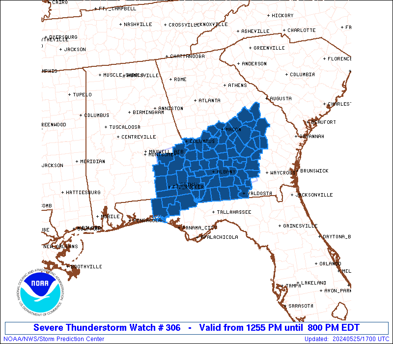
* Severe Thunderstorm Watch for portions of
Southeast Alabama
Western Florida Panhandle
Central and Southern Georgia
* Effective this Saturday afternoon and evening from 1255 PM
until 800 PM EDT.
* Primary threats include...
Scattered damaging wind gusts to 70 mph possible
Isolated large hail events to 1.5 inches in diameter possible
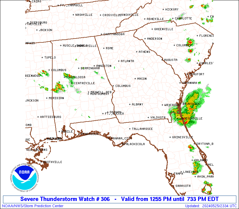
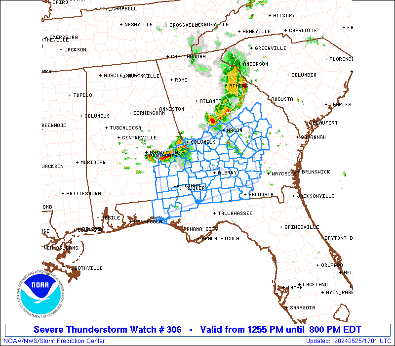
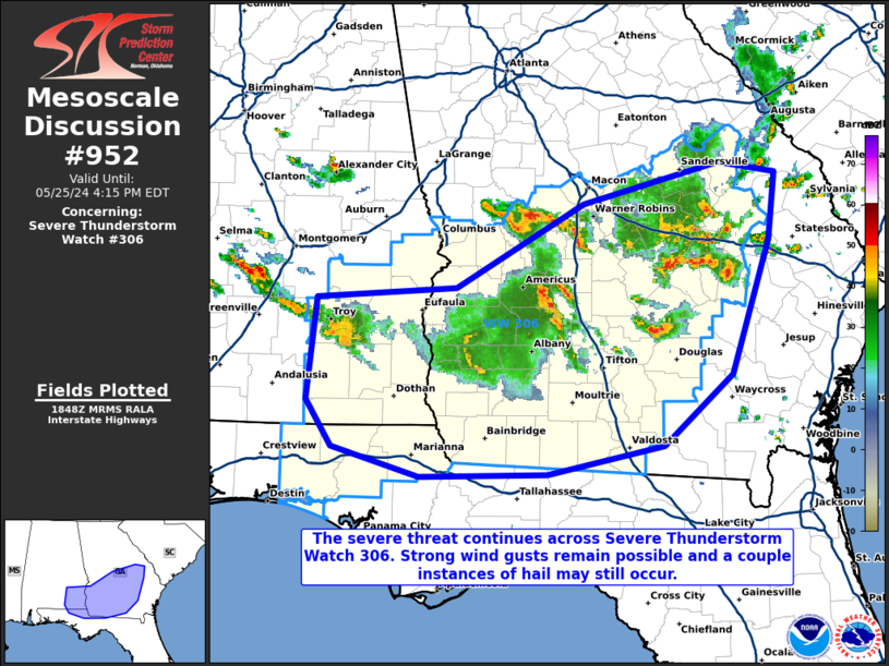
SUMMARY...Clusters of strong to severe thunderstorms will move
southeast across the watch area this afternoon, posing a risk for
damaging wind gusts and large hail up to 1.5 inches in diameter.
The severe thunderstorm watch area is approximately along and 60
statute miles north and south of a line from 30 miles south of Troy
AL to 85 miles northeast of Moultrie GA. For a complete depiction of
the watch see the associated watch outline update (WOUS64 KWNS
WOU6).
PRECAUTIONARY/PREPAREDNESS ACTIONS...
REMEMBER...A Severe Thunderstorm Watch means conditions are
favorable for severe thunderstorms in and close to the watch area.
Persons in these areas should be on the lookout for threatening
weather conditions and listen for later statements and possible
warnings. Severe thunderstorms can and occasionally do produce
tornadoes.
&&
AVIATION...A few severe thunderstorms with hail surface and aloft to
1.5 inches. Extreme turbulence and surface wind gusts to 60 knots. A
few cumulonimbi with maximum tops to 500. Mean storm motion vector
30025.
...Bunting
   SEL6

   URGENT - IMMEDIATE BROADCAST REQUESTED
   Severe Thunderstorm Watch Number 306
   NWS Storm Prediction Center Norman OK
   1255 PM EDT Sat May 25 2024

   The NWS Storm Prediction Center has issued a

   * Severe Thunderstorm Watch for portions of
     Southeast Alabama
     Western Florida Panhandle
     Central and Southern Georgia

   * Effective this Saturday afternoon and evening from 1255 PM
     until 800 PM EDT.

   * Primary threats include...
     Scattered damaging wind gusts to 70 mph possible
     Isolated large hail events to 1.5 inches in diameter possible

   SUMMARY...Clusters of strong to severe thunderstorms will move
   southeast across the watch area this afternoon, posing a risk for
   damaging wind gusts and large hail up to 1.5 inches in diameter.

   The severe thunderstorm watch area is approximately along and 60
   statute miles north and south of a line from 30 miles south of Troy
   AL to 85 miles northeast of Moultrie GA. For a complete depiction of
   the watch see the associated watch outline update (WOUS64 KWNS
   WOU6).

   PRECAUTIONARY/PREPAREDNESS ACTIONS...

   REMEMBER...A Severe Thunderstorm Watch means conditions are
   favorable for severe thunderstorms in and close to the watch area.
   Persons in these areas should be on the lookout for threatening
   weather conditions and listen for later statements and possible
   warnings. Severe thunderstorms can and occasionally do produce
   tornadoes.

   &&

   AVIATION...A few severe thunderstorms with hail surface and aloft to
   1.5 inches. Extreme turbulence and surface wind gusts to 60 knots. A
   few cumulonimbi with maximum tops to 500. Mean storm motion vector
   30025.

   ...Bunting
 Note:
The Aviation Watch (SAW) product is an approximation to the watch area.
The actual watch is depicted by the shaded areas.
Note:
The Aviation Watch (SAW) product is an approximation to the watch area.
The actual watch is depicted by the shaded areas.
   SAW6
   WW 306 SEVERE TSTM AL FL GA 251655Z - 260000Z
   AXIS..60 STATUTE MILES NORTH AND SOUTH OF LINE..
   30S TOI/TROY AL/ - 85NE MGR/MOULTRIE GA/
   ..AVIATION COORDS.. 50NM N/S /50SSE MGM - 28NNW AMG/
   HAIL SURFACE AND ALOFT..1.5 INCHES. WIND GUSTS..60 KNOTS.
   MAX TOPS TO 500. MEAN STORM MOTION VECTOR 30025.

   LAT...LON 32308602 32818277 31088277 30578602

   THIS IS AN APPROXIMATION TO THE WATCH AREA.  FOR A
   COMPLETE DEPICTION OF THE WATCH SEE WOUS64 KWNS
   FOR WOU6.
Watch 306 Status Report Messages:
STATUS REPORT #4 ON WW 306

VALID 252230Z - 252340Z

SEVERE WEATHER THREAT CONTINUES RIGHT OF A LINE FROM 15 N TOI TO
30 NNE DHN TO 20 WSW ABY TO 10 N MGR TO 35 ENE MGR TO 35 NW AYS
TO 15 SSE VDI.

..LYONS..05/25/24

ATTN...WFO...BMX...TAE...JAX...FFC...

&&

STATUS REPORT FOR WS 306

SEVERE WEATHER THREAT CONTINUES FOR THE FOLLOWING AREAS

ALC031-045-061-067-069-109-252340-

AL
.    ALABAMA COUNTIES INCLUDED ARE

COFFEE		     DALE		 GENEVA
HENRY		     HOUSTON		 PIKE
$$


FLC059-063-131-133-252340-

FL
.    FLORIDA COUNTIES INCLUDED ARE

HOLMES		     JACKSON		 WALTON
WASHINGTON
$$


GAC007-019-027-071-075-087-099-131-173-185-201-205-253-275-
252340-

GA
.    GEORGIA COUNTIES INCLUDED ARE

BAKER		     BERRIEN		 BROOKS
COLQUITT	     COOK		 DECATUR
EARLY		     GRADY		 LANIER
LOWNDES 	     MILLER		 MITCHELL
SEMINOLE	     THOMAS
$$


THE WATCH STATUS MESSAGE IS FOR GUIDANCE PURPOSES ONLY.  PLEASE
REFER TO WATCH COUNTY NOTIFICATION STATEMENTS FOR OFFICIAL
INFORMATION ON COUNTIES...INDEPENDENT CITIES AND MARINE ZONES
CLEARED FROM SEVERE THUNDERSTORM AND TORNADO WATCHES.
$$

STATUS REPORT #3 ON WW 306

VALID 252100Z - 252240Z

SEVERE WEATHER THREAT CONTINUES RIGHT OF A LINE FROM 25 SW AUO TO
40 WNW ABY TO 15 NE ABY TO 55 ENE ABY TO 10 SSW VDI TO 30 ENE VDI.

..LYONS..05/25/24

ATTN...WFO...BMX...TAE...JAX...FFC...

&&

STATUS REPORT FOR WS 306

SEVERE WEATHER THREAT CONTINUES FOR THE FOLLOWING AREAS

ALC005-031-045-061-067-069-109-252240-

AL
.    ALABAMA COUNTIES INCLUDED ARE

BARBOUR 	     COFFEE		 DALE
GENEVA		     HENRY		 HOUSTON
PIKE
$$


FLC059-063-131-133-252240-

FL
.    FLORIDA COUNTIES INCLUDED ARE

HOLMES		     JACKSON		 WALTON
WASHINGTON
$$


GAC003-007-017-019-027-037-061-069-071-075-087-095-099-131-155-
161-173-177-185-201-205-239-243-253-271-273-275-277-279-287-309-
321-252240-

GA
.    GEORGIA COUNTIES INCLUDED ARE

ATKINSON	     BAKER		 BEN HILL
BERRIEN 	     BROOKS		 CALHOUN
CLAY		     COFFEE		 COLQUITT
COOK		     DECATUR		 DOUGHERTY
EARLY		     GRADY		 IRWIN
JEFF DAVIS	     LANIER		 LEE
LOWNDES 	     MILLER		 MITCHELL
QUITMAN 	     RANDOLPH		 SEMINOLE
TELFAIR 	     TERRELL		 THOMAS
TIFT		     TOOMBS		 TURNER
WHEELER 	     WORTH
$$


THE WATCH STATUS MESSAGE IS FOR GUIDANCE PURPOSES ONLY.  PLEASE
REFER TO WATCH COUNTY NOTIFICATION STATEMENTS FOR OFFICIAL
INFORMATION ON COUNTIES...INDEPENDENT CITIES AND MARINE ZONES
CLEARED FROM SEVERE THUNDERSTORM AND TORNADO WATCHES.
$$

STATUS REPORT #2 ON WW 306

VALID 251950Z - 252040Z

SEVERE WEATHER THREAT CONTINUES RIGHT OF A LINE FROM 25 SW AUO TO
40 SSW CSG TO 45 S CSG TO 30 NNW ABY TO 40 N ABY TO 20 SW MCN TO
25 ENE MCN.

..LYONS..05/25/24

ATTN...WFO...BMX...TAE...JAX...FFC...

&&

STATUS REPORT FOR WS 306

SEVERE WEATHER THREAT CONTINUES FOR THE FOLLOWING AREAS

ALC005-031-045-061-067-069-109-252040-

AL
.    ALABAMA COUNTIES INCLUDED ARE

BARBOUR 	     COFFEE		 DALE
GENEVA		     HENRY		 HOUSTON
PIKE
$$


FLC059-063-131-133-252040-

FL
.    FLORIDA COUNTIES INCLUDED ARE

HOLMES		     JACKSON		 WALTON
WASHINGTON
$$


GAC003-007-017-019-023-027-037-061-069-071-075-081-087-091-093-
095-099-107-131-153-155-161-163-167-173-175-177-185-193-201-205-
209-225-235-239-243-253-261-271-273-275-277-279-283-287-289-303-
309-315-319-321-252040-

GA
.    GEORGIA COUNTIES INCLUDED ARE

ATKINSON	     BAKER		 BEN HILL
BERRIEN 	     BLECKLEY		 BROOKS
CALHOUN 	     CLAY		 COFFEE
COLQUITT	     COOK		 CRISP
DECATUR 	     DODGE		 DOOLY
DOUGHERTY	     EARLY		 EMANUEL
GRADY		     HOUSTON		 IRWIN
JEFF DAVIS	     JEFFERSON		 JOHNSON
LANIER		     LAURENS		 LEE
LOWNDES 	     MACON		 MILLER
MITCHELL	     MONTGOMERY 	 PEACH
PULASKI 	     QUITMAN		 RANDOLPH
SEMINOLE	     SUMTER		 TELFAIR
TERRELL 	     THOMAS		 TIFT
TOOMBS		     TREUTLEN		 TURNER
TWIGGS		     WASHINGTON 	 WHEELER
WILCOX		     WILKINSON		 WORTH
$$


THE WATCH STATUS MESSAGE IS FOR GUIDANCE PURPOSES ONLY.  PLEASE
REFER TO WATCH COUNTY NOTIFICATION STATEMENTS FOR OFFICIAL
INFORMATION ON COUNTIES...INDEPENDENT CITIES AND MARINE ZONES
CLEARED FROM SEVERE THUNDERSTORM AND TORNADO WATCHES.
$$

STATUS REPORT #1 ON WW 306

VALID 251840Z - 251940Z

THE SEVERE WEATHER THREAT CONTINUES ACROSS THE ENTIRE WATCH AREA.

..LYONS..05/25/24

ATTN...WFO...BMX...TAE...JAX...FFC...

&&

STATUS REPORT FOR WS 306

SEVERE WEATHER THREAT CONTINUES FOR THE FOLLOWING AREAS

ALC005-011-031-045-061-067-069-109-113-251940-

AL
.    ALABAMA COUNTIES INCLUDED ARE

BARBOUR 	     BULLOCK		 COFFEE
DALE		     GENEVA		 HENRY
HOUSTON 	     PIKE		 RUSSELL
$$


FLC059-063-131-133-251940-

FL
.    FLORIDA COUNTIES INCLUDED ARE

HOLMES		     JACKSON		 WALTON
WASHINGTON
$$


GAC003-007-017-019-021-023-027-037-053-061-069-071-075-079-081-
087-091-093-095-099-107-131-153-155-161-163-167-173-175-177-185-
193-197-201-205-209-215-225-235-239-243-249-253-259-261-269-271-
273-275-277-279-283-287-289-303-307-309-315-319-321-251940-

GA
.    GEORGIA COUNTIES INCLUDED ARE

ATKINSON	     BAKER		 BEN HILL
BERRIEN 	     BIBB		 BLECKLEY
BROOKS		     CALHOUN		 CHATTAHOOCHEE
CLAY		     COFFEE		 COLQUITT
COOK		     CRAWFORD		 CRISP
DECATUR 	     DODGE		 DOOLY
DOUGHERTY	     EARLY		 EMANUEL
GRADY		     HOUSTON		 IRWIN
JEFF DAVIS	     JEFFERSON		 JOHNSON
LANIER		     LAURENS		 LEE
LOWNDES 	     MACON		 MARION
MILLER		     MITCHELL		 MONTGOMERY
MUSCOGEE	     PEACH		 PULASKI
QUITMAN 	     RANDOLPH		 SCHLEY
SEMINOLE	     STEWART		 SUMTER
TAYLOR		     TELFAIR		 TERRELL
THOMAS		     TIFT		 TOOMBS
TREUTLEN	     TURNER		 TWIGGS
WASHINGTON	     WEBSTER		 WHEELER
WILCOX		     WILKINSON		 WORTH
$$


THE WATCH STATUS MESSAGE IS FOR GUIDANCE PURPOSES ONLY.  PLEASE
REFER TO WATCH COUNTY NOTIFICATION STATEMENTS FOR OFFICIAL
INFORMATION ON COUNTIES...INDEPENDENT CITIES AND MARINE ZONES
CLEARED FROM SEVERE THUNDERSTORM AND TORNADO WATCHES.
$$
Note:
Click for Complete Product Text.
Tornadoes
Probability of 2 or more tornadoes
|
Low (<5%)
|
Probability of 1 or more strong (EF2-EF5) tornadoes
|
Low (<2%)
|
Wind
Probability of 10 or more severe wind events
|
Mod (40%)
|
Probability of 1 or more wind events > 65 knots
|
Low (20%)
|
Hail
Probability of 10 or more severe hail events
|
Mod (30%)
|
Probability of 1 or more hailstones > 2 inches
|
Low (20%)
|
Combined Severe Hail/Wind
Probability of 6 or more combined severe hail/wind events
|
High (70%)
|
For each watch, probabilities for particular events inside the watch
(listed above in each table) are determined by the issuing forecaster.
The "Low" category contains probability values ranging from less than 2%
to 20% (EF2-EF5 tornadoes), less than 5% to 20% (all other probabilities),
"Moderate" from 30% to 60%, and "High" from 70% to greater than 95%.
High values are bolded and lighter in color to provide awareness of
an increased threat for a particular event.


 @NWSSPC