 Note:
The expiration time in the watch graphic is amended if the watch is
replaced, cancelled or extended.
Note:
Note:
The expiration time in the watch graphic is amended if the watch is
replaced, cancelled or extended.
Note: Click for
Watch Status Reports.
SEL7
URGENT - IMMEDIATE BROADCAST REQUESTED
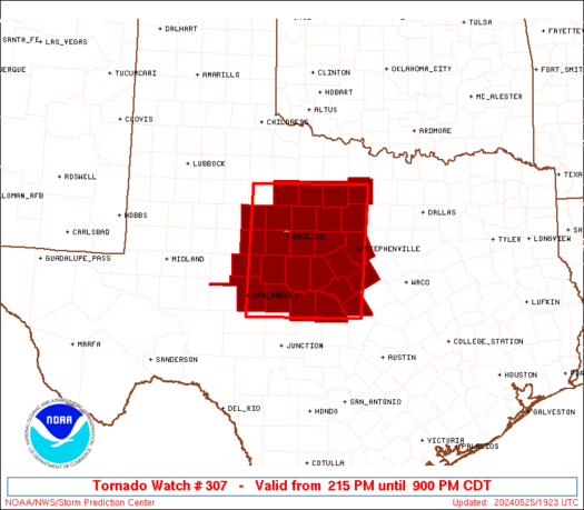
Tornado Watch Number 307
NWS Storm Prediction Center Norman OK
215 PM CDT Sat May 25 2024
The NWS Storm Prediction Center has issued a
* Tornado Watch for portions of
Northwest Texas
* Effective this Saturday afternoon and evening from 215 PM until
900 PM CDT.
* Primary threats include...
A couple tornadoes possible
Scattered large hail and isolated very large hail events to 4
inches in diameter likely
Scattered damaging wind gusts to 70 mph likely
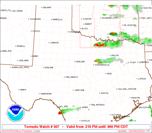
SUMMARY...Isolated supercell thunderstorms will move east across the
watch area through early this evening. Very large hail, up to 4
inches in diameter, will be possible in addition to a couple of
tornadoes and damaging thunderstorm wind gusts.
The tornado watch area is approximately along and 70 statute miles
east and west of a line from 70 miles north northeast of Abilene TX
to 60 miles south southwest of Brownwood TX. For a complete
depiction of the watch see the associated watch outline update
(WOUS64 KWNS WOU7).
PRECAUTIONARY/PREPAREDNESS ACTIONS...
REMEMBER...A Tornado Watch means conditions are favorable for
tornadoes and severe thunderstorms in and close to the watch
area. Persons in these areas should be on the lookout for
threatening weather conditions and listen for later statements
and possible warnings.
&&
OTHER WATCH INFORMATION...CONTINUE...WW 306...
AVIATION...Tornadoes and a few severe thunderstorms with hail
surface and aloft to 4 inches. Extreme turbulence and surface wind
gusts to 60 knots. A few cumulonimbi with maximum tops to 550. Mean
storm motion vector 27020.
...Bunting

   SEL7

   URGENT - IMMEDIATE BROADCAST REQUESTED
   Tornado Watch Number 307
   NWS Storm Prediction Center Norman OK
   215 PM CDT Sat May 25 2024

   The NWS Storm Prediction Center has issued a

   * Tornado Watch for portions of
     Northwest Texas

   * Effective this Saturday afternoon and evening from 215 PM until
     900 PM CDT.

   * Primary threats include...
     A couple tornadoes possible
     Scattered large hail and isolated very large hail events to 4
       inches in diameter likely
     Scattered damaging wind gusts to 70 mph likely

   SUMMARY...Isolated supercell thunderstorms will move east across the
   watch area through early this evening.  Very large hail, up to 4
   inches in diameter, will be possible in addition to a couple of
   tornadoes and damaging thunderstorm wind gusts.

   The tornado watch area is approximately along and 70 statute miles
   east and west of a line from 70 miles north northeast of Abilene TX
   to 60 miles south southwest of Brownwood TX. For a complete
   depiction of the watch see the associated watch outline update
   (WOUS64 KWNS WOU7).

   PRECAUTIONARY/PREPAREDNESS ACTIONS...

   REMEMBER...A Tornado Watch means conditions are favorable for
   tornadoes and severe thunderstorms in and close to the watch
   area. Persons in these areas should be on the lookout for
   threatening weather conditions and listen for later statements
   and possible warnings.

   &&

   OTHER WATCH INFORMATION...CONTINUE...WW 306...

   AVIATION...Tornadoes and a few severe thunderstorms with hail
   surface and aloft to 4 inches. Extreme turbulence and surface wind
   gusts to 60 knots. A few cumulonimbi with maximum tops to 550. Mean
   storm motion vector 27020.

   ...Bunting
 Note:
The Aviation Watch (SAW) product is an approximation to the watch area.
The actual watch is depicted by the shaded areas.
Note:
The Aviation Watch (SAW) product is an approximation to the watch area.
The actual watch is depicted by the shaded areas.
   SAW7
   WW 307 TORNADO TX 251915Z - 260200Z
   AXIS..70 STATUTE MILES EAST AND WEST OF LINE..
   70NNE ABI/ABILENE TX/ - 60SSW BWD/BROWNWOOD TX/
   ..AVIATION COORDS.. 60NM E/W /49SW SPS - 34NE JCT/
   HAIL SURFACE AND ALOFT..4 INCHES. WIND GUSTS..60 KNOTS.
   MAX TOPS TO 550. MEAN STORM MOTION VECTOR 27020.

   LAT...LON 33349800 30999816 30990052 33340043

   THIS IS AN APPROXIMATION TO THE WATCH AREA.  FOR A
   COMPLETE DEPICTION OF THE WATCH SEE WOUS64 KWNS
   FOR WOU7.
Watch 307 Status Report Messages:
STATUS REPORT #2 ON WW 307

VALID 260055Z - 260140Z

THE SEVERE WEATHER THREAT CONTINUES ACROSS THE ENTIRE WATCH AREA.

..LYONS..05/26/24

ATTN...WFO...SJT...FWD...

&&

STATUS REPORT FOR WT 307

SEVERE WEATHER THREAT CONTINUES FOR THE FOLLOWING AREAS

TXC049-059-081-083-093-095-133-143-151-193-207-237-253-281-307-
333-353-363-399-411-417-429-441-447-451-503-260140-

TX
.    TEXAS COUNTIES INCLUDED ARE

BROWN		     CALLAHAN		 COKE
COLEMAN 	     COMANCHE		 CONCHO
EASTLAND	     ERATH		 FISHER
HAMILTON	     HASKELL		 JACK
JONES		     LAMPASAS		 MCCULLOCH
MILLS		     NOLAN		 PALO PINTO
RUNNELS 	     SAN SABA		 SHACKELFORD
STEPHENS	     TAYLOR		 THROCKMORTON
TOM GREEN	     YOUNG
$$


THE WATCH STATUS MESSAGE IS FOR GUIDANCE PURPOSES ONLY.  PLEASE
REFER TO WATCH COUNTY NOTIFICATION STATEMENTS FOR OFFICIAL
INFORMATION ON COUNTIES...INDEPENDENT CITIES AND MARINE ZONES
CLEARED FROM SEVERE THUNDERSTORM AND TORNADO WATCHES.
$$

STATUS REPORT #1 ON WW 307

VALID 252110Z - 252240Z

THE SEVERE WEATHER THREAT CONTINUES ACROSS THE ENTIRE WATCH AREA.

..LYONS..05/25/24

ATTN...WFO...SJT...FWD...

&&

STATUS REPORT FOR WT 307

SEVERE WEATHER THREAT CONTINUES FOR THE FOLLOWING AREAS

TXC049-059-081-083-093-095-133-143-151-193-207-237-253-281-307-
333-353-363-399-411-417-429-441-447-451-503-252240-

TX
.    TEXAS COUNTIES INCLUDED ARE

BROWN		     CALLAHAN		 COKE
COLEMAN 	     COMANCHE		 CONCHO
EASTLAND	     ERATH		 FISHER
HAMILTON	     HASKELL		 JACK
JONES		     LAMPASAS		 MCCULLOCH
MILLS		     NOLAN		 PALO PINTO
RUNNELS 	     SAN SABA		 SHACKELFORD
STEPHENS	     TAYLOR		 THROCKMORTON
TOM GREEN	     YOUNG
$$


THE WATCH STATUS MESSAGE IS FOR GUIDANCE PURPOSES ONLY.  PLEASE
REFER TO WATCH COUNTY NOTIFICATION STATEMENTS FOR OFFICIAL
INFORMATION ON COUNTIES...INDEPENDENT CITIES AND MARINE ZONES
CLEARED FROM SEVERE THUNDERSTORM AND TORNADO WATCHES.
$$
Note:
Click for Complete Product Text.
Tornadoes
Probability of 2 or more tornadoes
|
Mod (40%)
|
Probability of 1 or more strong (EF2-EF5) tornadoes
|
Low (20%)
|
Wind
Probability of 10 or more severe wind events
|
Mod (60%)
|
Probability of 1 or more wind events > 65 knots
|
Low (20%)
|
Hail
Probability of 10 or more severe hail events
|
Mod (60%)
|
Probability of 1 or more hailstones > 2 inches
|
Mod (60%)
|
Combined Severe Hail/Wind
Probability of 6 or more combined severe hail/wind events
|
High (>95%)
|
For each watch, probabilities for particular events inside the watch
(listed above in each table) are determined by the issuing forecaster.
The "Low" category contains probability values ranging from less than 2%
to 20% (EF2-EF5 tornadoes), less than 5% to 20% (all other probabilities),
"Moderate" from 30% to 60%, and "High" from 70% to greater than 95%.
High values are bolded and lighter in color to provide awareness of
an increased threat for a particular event.


 @NWSSPC


