Note:
The expiration time in the watch graphic is amended if the watch is
replaced, cancelled or extended.
Note:
Note:
The expiration time in the watch graphic is amended if the watch is
replaced, cancelled or extended.
Note: Click for
Watch Status Reports.
SEL5
URGENT - IMMEDIATE BROADCAST REQUESTED
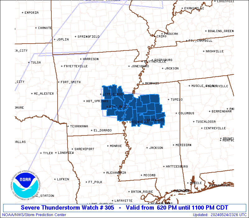
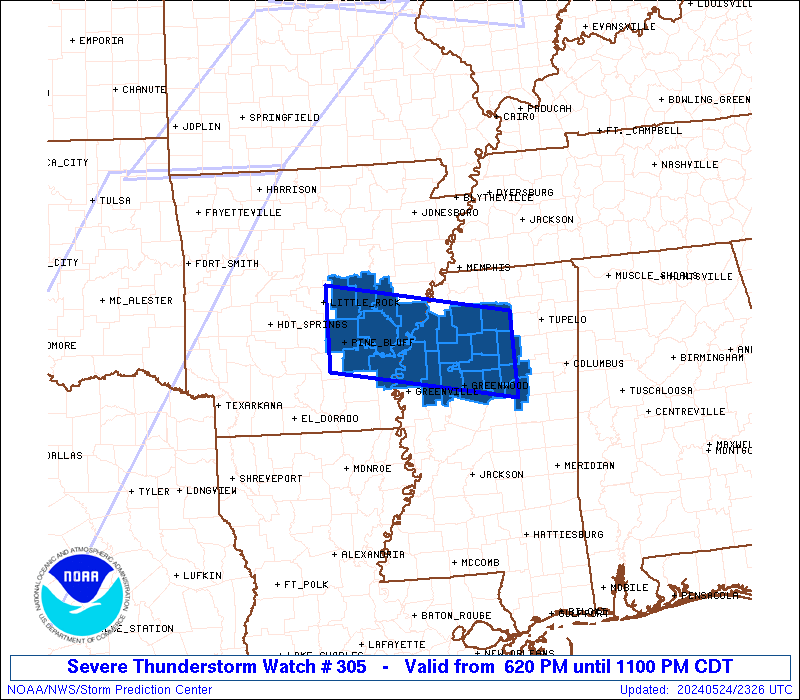
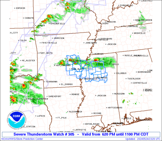
Severe Thunderstorm Watch Number 305
NWS Storm Prediction Center Norman OK
620 PM CDT Fri May 24 2024
The NWS Storm Prediction Center has issued a
* Severe Thunderstorm Watch for portions of
Southeast Arkansas
Northwest Mississippi
* Effective this Friday evening from 620 PM until 1100 PM CDT.
* Primary threats include...
Scattered large hail and isolated very large hail events to 2
inches in diameter possible
Isolated damaging wind gusts to 70 mph possible
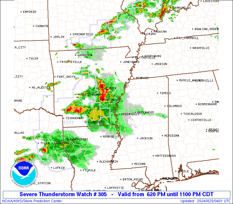
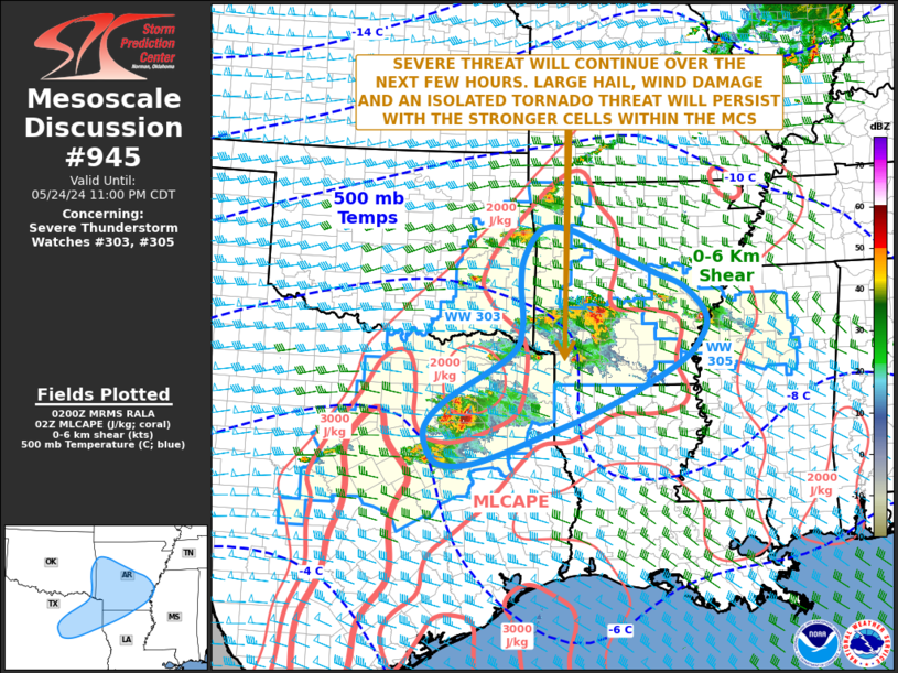
SUMMARY...Scattered storms, some with supercell structure, may
persist for a few more hours while moving southeastward across
southeast Arkansas and northwest Mississippi. Occasional large hail
of 1-2 inches in diameter and damaging gusts of 60-70 mph will be
the main threats through late evening.
The severe thunderstorm watch area is approximately along and 40
statute miles north and south of a line from 20 miles northwest of
Pine Bluff AR to 40 miles south southeast of Oxford MS. For a
complete depiction of the watch see the associated watch outline
update (WOUS64 KWNS WOU5).
PRECAUTIONARY/PREPAREDNESS ACTIONS...
REMEMBER...A Severe Thunderstorm Watch means conditions are
favorable for severe thunderstorms in and close to the watch area.
Persons in these areas should be on the lookout for threatening
weather conditions and listen for later statements and possible
warnings. Severe thunderstorms can and occasionally do produce
tornadoes.
&&
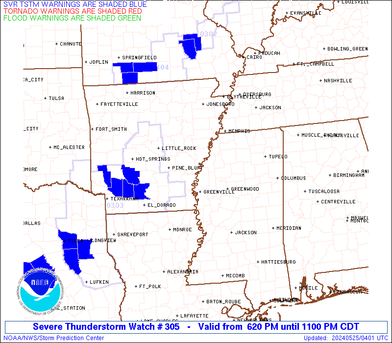
OTHER WATCH INFORMATION...CONTINUE...WW 302...WW 303...WW 304...
AVIATION...A few severe thunderstorms with hail surface and aloft to
2 inches. Extreme turbulence and surface wind gusts to 60 knots. A
few cumulonimbi with maximum tops to 550. Mean storm motion vector
31020.
...Thompson
   SEL5

   URGENT - IMMEDIATE BROADCAST REQUESTED
   Severe Thunderstorm Watch Number 305
   NWS Storm Prediction Center Norman OK
   620 PM CDT Fri May 24 2024

   The NWS Storm Prediction Center has issued a

   * Severe Thunderstorm Watch for portions of
     Southeast Arkansas
     Northwest Mississippi

   * Effective this Friday evening from 620 PM until 1100 PM CDT.

   * Primary threats include...
     Scattered large hail and isolated very large hail events to 2
       inches in diameter possible
     Isolated damaging wind gusts to 70 mph possible

   SUMMARY...Scattered storms, some with supercell structure, may
   persist for a few more hours while moving southeastward across
   southeast Arkansas and northwest Mississippi.  Occasional large hail
   of 1-2 inches in diameter and damaging gusts of 60-70 mph will be
   the main threats through late evening.

   The severe thunderstorm watch area is approximately along and 40
   statute miles north and south of a line from 20 miles northwest of
   Pine Bluff AR to 40 miles south southeast of Oxford MS. For a
   complete depiction of the watch see the associated watch outline
   update (WOUS64 KWNS WOU5).

   PRECAUTIONARY/PREPAREDNESS ACTIONS...

   REMEMBER...A Severe Thunderstorm Watch means conditions are
   favorable for severe thunderstorms in and close to the watch area.
   Persons in these areas should be on the lookout for threatening
   weather conditions and listen for later statements and possible
   warnings. Severe thunderstorms can and occasionally do produce
   tornadoes.

   &&

   OTHER WATCH INFORMATION...CONTINUE...WW 302...WW 303...WW 304...

   AVIATION...A few severe thunderstorms with hail surface and aloft to
   2 inches. Extreme turbulence and surface wind gusts to 60 knots. A
   few cumulonimbi with maximum tops to 550. Mean storm motion vector
   31020.

   ...Thompson
 Note:
The Aviation Watch (SAW) product is an approximation to the watch area.
The actual watch is depicted by the shaded areas.
Note:
The Aviation Watch (SAW) product is an approximation to the watch area.
The actual watch is depicted by the shaded areas.
   SAW5
   WW 305 SEVERE TSTM AR MS 242320Z - 250400Z
   AXIS..40 STATUTE MILES NORTH AND SOUTH OF LINE..
   20NW PBF/PINE BLUFF AR/ - 40SSE UOX/OXFORD MS/
   ..AVIATION COORDS.. 35NM N/S /18S LIT - 43WNW IGB/
   HAIL SURFACE AND ALOFT..2 INCHES. WIND GUSTS..60 KNOTS.
   MAX TOPS TO 550. MEAN STORM MOTION VECTOR 31020.

   LAT...LON 34959218 34418926 33278926 33809218

   THIS IS AN APPROXIMATION TO THE WATCH AREA.  FOR A
   COMPLETE DEPICTION OF THE WATCH SEE WOUS64 KWNS
   FOR WOU5.
Watch 305 Status Report Messages:
STATUS REPORT #2 ON WW 305

VALID 250050Z - 250140Z

SEVERE WEATHER THREAT CONTINUES RIGHT OF A LINE FROM 10 SW LIT TO
55 ENE LIT.

..LYONS..05/25/24

ATTN...WFO...LZK...MEG...JAN...

&&

STATUS REPORT FOR WS 305

SEVERE WEATHER THREAT CONTINUES FOR THE FOLLOWING AREAS

ARC001-041-069-079-095-107-250140-

AR
.    ARKANSAS COUNTIES INCLUDED ARE

ARKANSAS	     DESHA		 JEFFERSON
LINCOLN 	     MONROE		 PHILLIPS
$$


MSC011-013-015-019-027-043-071-083-097-107-119-133-135-155-161-
250140-

MS
.    MISSISSIPPI COUNTIES INCLUDED ARE

BOLIVAR 	     CALHOUN		 CARROLL
CHOCTAW 	     COAHOMA		 GRENADA
LAFAYETTE	     LEFLORE		 MONTGOMERY
PANOLA		     QUITMAN		 SUNFLOWER
TALLAHATCHIE	     WEBSTER		 YALOBUSHA
$$


THE WATCH STATUS MESSAGE IS FOR GUIDANCE PURPOSES ONLY.  PLEASE
REFER TO WATCH COUNTY NOTIFICATION STATEMENTS FOR OFFICIAL
INFORMATION ON COUNTIES...INDEPENDENT CITIES AND MARINE ZONES
CLEARED FROM SEVERE THUNDERSTORM AND TORNADO WATCHES.
$$

STATUS REPORT #1 ON WW 305

VALID 242330Z - 250040Z

THE SEVERE WEATHER THREAT CONTINUES ACROSS THE ENTIRE WATCH AREA.

..LYONS..05/24/24

ATTN...WFO...LZK...MEG...JAN...

&&

STATUS REPORT FOR WS 305

SEVERE WEATHER THREAT CONTINUES FOR THE FOLLOWING AREAS

ARC001-041-069-079-085-095-107-117-250040-

AR
.    ARKANSAS COUNTIES INCLUDED ARE

ARKANSAS	     DESHA		 JEFFERSON
LINCOLN 	     LONOKE		 MONROE
PHILLIPS	     PRAIRIE
$$


MSC011-013-015-019-027-043-071-083-097-107-119-133-135-155-161-
250040-

MS
.    MISSISSIPPI COUNTIES INCLUDED ARE

BOLIVAR 	     CALHOUN		 CARROLL
CHOCTAW 	     COAHOMA		 GRENADA
LAFAYETTE	     LEFLORE		 MONTGOMERY
PANOLA		     QUITMAN		 SUNFLOWER
TALLAHATCHIE	     WEBSTER		 YALOBUSHA
$$


THE WATCH STATUS MESSAGE IS FOR GUIDANCE PURPOSES ONLY.  PLEASE
REFER TO WATCH COUNTY NOTIFICATION STATEMENTS FOR OFFICIAL
INFORMATION ON COUNTIES...INDEPENDENT CITIES AND MARINE ZONES
CLEARED FROM SEVERE THUNDERSTORM AND TORNADO WATCHES.
$$
Note:
Click for Complete Product Text.
Tornadoes
Probability of 2 or more tornadoes
|
Low (10%)
|
Probability of 1 or more strong (EF2-EF5) tornadoes
|
Low (<2%)
|
Wind
Probability of 10 or more severe wind events
|
Mod (30%)
|
Probability of 1 or more wind events > 65 knots
|
Low (20%)
|
Hail
Probability of 10 or more severe hail events
|
Mod (40%)
|
Probability of 1 or more hailstones > 2 inches
|
Mod (30%)
|
Combined Severe Hail/Wind
Probability of 6 or more combined severe hail/wind events
|
Mod (60%)
|
For each watch, probabilities for particular events inside the watch
(listed above in each table) are determined by the issuing forecaster.
The "Low" category contains probability values ranging from less than 2%
to 20% (EF2-EF5 tornadoes), less than 5% to 20% (all other probabilities),
"Moderate" from 30% to 60%, and "High" from 70% to greater than 95%.
High values are bolded and lighter in color to provide awareness of
an increased threat for a particular event.


 @NWSSPC