Note:
The expiration time in the watch graphic is amended if the watch is
replaced, cancelled or extended.
Note:
Note:
The expiration time in the watch graphic is amended if the watch is
replaced, cancelled or extended.
Note: Click for
Watch Status Reports.
SEL4
URGENT - IMMEDIATE BROADCAST REQUESTED
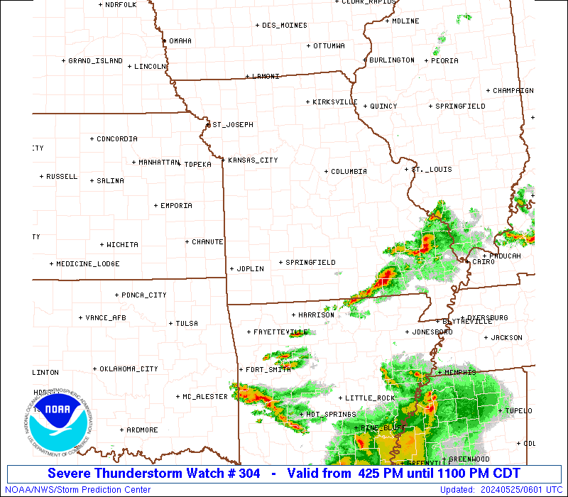
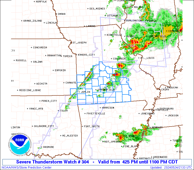
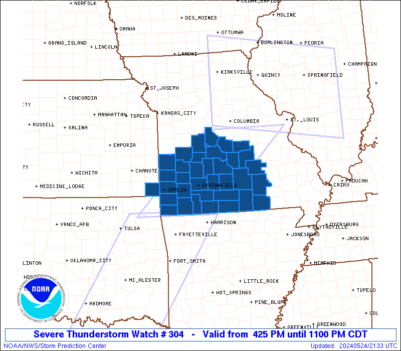
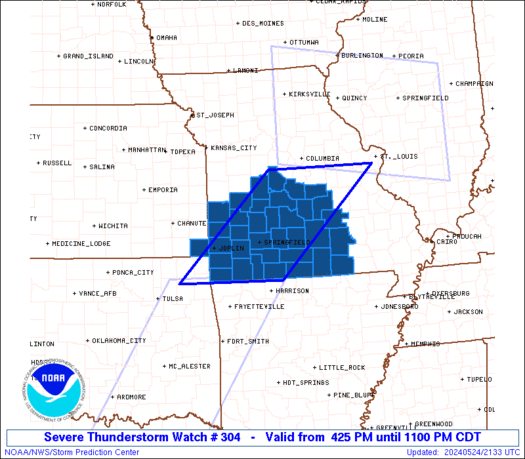
Severe Thunderstorm Watch Number 304
NWS Storm Prediction Center Norman OK
425 PM CDT Fri May 24 2024
The NWS Storm Prediction Center has issued a
* Severe Thunderstorm Watch for portions of
Extreme southeast Kansas
Southwest and south central Missouri
* Effective this Friday afternoon and evening from 425 PM until
1100 PM CDT.
* Primary threats include...
Scattered large hail and isolated very large hail events to 2.5
inches in diameter likely
Scattered damaging wind gusts to 70 mph possible
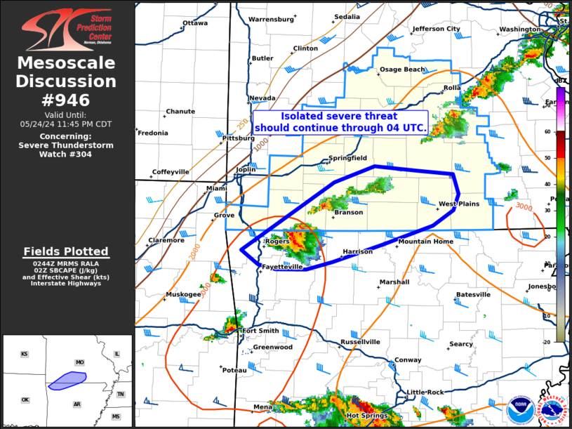
SUMMARY...Thunderstorms are forming along a cold front and in the
open warm sector across southwest and south central Missouri. The
storm environment favors a mix of supercells and storm clusters
capable of producing isolated very large hail to 2.5 inches in
diameter and outflow gusts of 60-70 mph.
The severe thunderstorm watch area is approximately along and 70
statute miles east and west of a line from 35 miles north of Vichy
MO to 30 miles south southwest of Monett MO. For a complete
depiction of the watch see the associated watch outline update
(WOUS64 KWNS WOU4).
PRECAUTIONARY/PREPAREDNESS ACTIONS...
REMEMBER...A Severe Thunderstorm Watch means conditions are
favorable for severe thunderstorms in and close to the watch area.
Persons in these areas should be on the lookout for threatening
weather conditions and listen for later statements and possible
warnings. Severe thunderstorms can and occasionally do produce
tornadoes.
&&
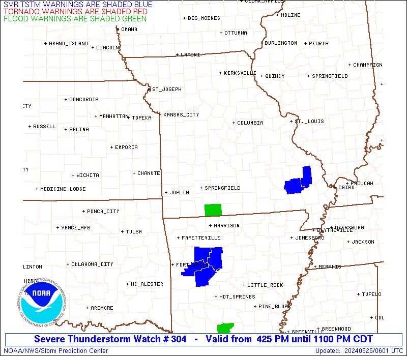
OTHER WATCH INFORMATION...CONTINUE...WW 302...WW 303...
AVIATION...A few severe thunderstorms with hail surface and aloft to
2.5 inches. Extreme turbulence and surface wind gusts to 60 knots. A
few cumulonimbi with maximum tops to 550. Mean storm motion vector
29025.
...Thompson
 Note:
The Aviation Watch (SAW) product is an approximation to the watch area.
The actual watch is depicted by the shaded areas.
Note:
The Aviation Watch (SAW) product is an approximation to the watch area.
The actual watch is depicted by the shaded areas.
   SAW4
   WW 304 SEVERE TSTM KS MO 242125Z - 250400Z
   AXIS..70 STATUTE MILES EAST AND WEST OF LINE..
   35N VIH/VICHY MO/ - 30SSW UMN/MONETT MO/
   ..AVIATION COORDS.. 60NM E/W /24ESE COU - 14N RZC/
   HAIL SURFACE AND ALOFT..2.5 INCHES. WIND GUSTS..60 KNOTS.
   MAX TOPS TO 550. MEAN STORM MOTION VECTOR 29025.

   LAT...LON 38639047 36479285 36479537 38639307

   THIS IS AN APPROXIMATION TO THE WATCH AREA.  FOR A
   COMPLETE DEPICTION OF THE WATCH SEE WOUS64 KWNS
   FOR WOU4.
Watch 304 Status Report Messages:
STATUS REPORT #4 ON WW 304

VALID 250135Z - 250240Z

SEVERE WEATHER THREAT CONTINUES RIGHT OF A LINE FROM 15 S GMJ TO
25 NW SGF TO 20 E COU.

..MOORE..05/25/24

ATTN...WFO...SGF...

&&

STATUS REPORT FOR WS 304

SEVERE WEATHER THREAT CONTINUES FOR THE FOLLOWING AREAS

MOC009-029-043-059-065-067-077-091-105-109-119-125-131-149-153-
161-167-169-203-209-213-215-225-229-250240-

MO
.    MISSOURI COUNTIES INCLUDED ARE

BARRY		     CAMDEN		 CHRISTIAN
DALLAS		     DENT		 DOUGLAS
GREENE		     HOWELL		 LACLEDE
LAWRENCE	     MCDONALD		 MARIES
MILLER		     OREGON		 OZARK
PHELPS		     POLK		 PULASKI
SHANNON 	     STONE		 TANEY
TEXAS		     WEBSTER		 WRIGHT
$$


THE WATCH STATUS MESSAGE IS FOR GUIDANCE PURPOSES ONLY.  PLEASE
REFER TO WATCH COUNTY NOTIFICATION STATEMENTS FOR OFFICIAL
INFORMATION ON COUNTIES...INDEPENDENT CITIES AND MARINE ZONES
CLEARED FROM SEVERE THUNDERSTORM AND TORNADO WATCHES.
$$

STATUS REPORT #3 ON WW 304

VALID 250045Z - 250140Z

SEVERE WEATHER THREAT CONTINUES RIGHT OF A LINE FROM 10 SE GMJ TO
30 NNW SGF TO 20 ENE JEF.

..LYONS..05/25/24

ATTN...WFO...SGF...

&&

STATUS REPORT FOR WS 304

SEVERE WEATHER THREAT CONTINUES FOR THE FOLLOWING AREAS

MOC009-029-043-059-065-067-077-091-105-109-119-125-131-149-153-
161-167-169-203-209-213-215-225-229-250140-

MO
.    MISSOURI COUNTIES INCLUDED ARE

BARRY		     CAMDEN		 CHRISTIAN
DALLAS		     DENT		 DOUGLAS
GREENE		     HOWELL		 LACLEDE
LAWRENCE	     MCDONALD		 MARIES
MILLER		     OREGON		 OZARK
PHELPS		     POLK		 PULASKI
SHANNON 	     STONE		 TANEY
TEXAS		     WEBSTER		 WRIGHT
$$


THE WATCH STATUS MESSAGE IS FOR GUIDANCE PURPOSES ONLY.  PLEASE
REFER TO WATCH COUNTY NOTIFICATION STATEMENTS FOR OFFICIAL
INFORMATION ON COUNTIES...INDEPENDENT CITIES AND MARINE ZONES
CLEARED FROM SEVERE THUNDERSTORM AND TORNADO WATCHES.
$$

STATUS REPORT #2 ON WW 304

VALID 242325Z - 250040Z

SEVERE WEATHER THREAT CONTINUES RIGHT OF A LINE FROM 35 W GMJ TO
5 W JLN TO 50 NNW SGF TO 30 W COU.

..LYONS..05/24/24

ATTN...WFO...SGF...

&&

STATUS REPORT FOR WS 304

SEVERE WEATHER THREAT CONTINUES FOR THE FOLLOWING AREAS

MOC009-015-029-039-043-057-059-065-067-077-085-091-097-105-109-
119-125-131-141-145-149-153-161-167-169-203-209-213-215-225-229-
250040-

MO
.    MISSOURI COUNTIES INCLUDED ARE

BARRY		     BENTON		 CAMDEN
CEDAR		     CHRISTIAN		 DADE
DALLAS		     DENT		 DOUGLAS
GREENE		     HICKORY		 HOWELL
JASPER		     LACLEDE		 LAWRENCE
MCDONALD	     MARIES		 MILLER
MORGAN		     NEWTON		 OREGON
OZARK		     PHELPS		 POLK
PULASKI 	     SHANNON		 STONE
TANEY		     TEXAS		 WEBSTER
WRIGHT
$$


THE WATCH STATUS MESSAGE IS FOR GUIDANCE PURPOSES ONLY.  PLEASE
REFER TO WATCH COUNTY NOTIFICATION STATEMENTS FOR OFFICIAL
INFORMATION ON COUNTIES...INDEPENDENT CITIES AND MARINE ZONES
CLEARED FROM SEVERE THUNDERSTORM AND TORNADO WATCHES.
$$

STATUS REPORT #1 ON WW 304

VALID 242150Z - 242240Z

THE SEVERE WEATHER THREAT CONTINUES ACROSS THE ENTIRE WATCH AREA.

..LYONS..05/24/24

ATTN...WFO...SGF...

&&

STATUS REPORT FOR WS 304

SEVERE WEATHER THREAT CONTINUES FOR THE FOLLOWING AREAS

KSC021-242240-

KS
.    KANSAS COUNTIES INCLUDED ARE

CHEROKEE
$$


MOC009-011-015-029-039-043-057-059-065-067-077-085-091-097-105-
109-119-125-131-141-145-149-153-161-167-169-185-203-209-213-215-
217-225-229-242240-

MO
.    MISSOURI COUNTIES INCLUDED ARE

BARRY		     BARTON		 BENTON
CAMDEN		     CEDAR		 CHRISTIAN
DADE		     DALLAS		 DENT
DOUGLAS 	     GREENE		 HICKORY
HOWELL		     JASPER		 LACLEDE
LAWRENCE	     MCDONALD		 MARIES
MILLER		     MORGAN		 NEWTON
OREGON		     OZARK		 PHELPS
POLK		     PULASKI		 ST. CLAIR
SHANNON 	     STONE		 TANEY
TEXAS		     VERNON		 WEBSTER
WRIGHT
$$


THE WATCH STATUS MESSAGE IS FOR GUIDANCE PURPOSES ONLY.  PLEASE
REFER TO WATCH COUNTY NOTIFICATION STATEMENTS FOR OFFICIAL
INFORMATION ON COUNTIES...INDEPENDENT CITIES AND MARINE ZONES
CLEARED FROM SEVERE THUNDERSTORM AND TORNADO WATCHES.
$$
Note:
Click for Complete Product Text.
Tornadoes
Probability of 2 or more tornadoes
|
Low (10%)
|
Probability of 1 or more strong (EF2-EF5) tornadoes
|
Low (<2%)
|
Wind
Probability of 10 or more severe wind events
|
Mod (40%)
|
Probability of 1 or more wind events > 65 knots
|
Low (20%)
|
Hail
Probability of 10 or more severe hail events
|
Mod (60%)
|
Probability of 1 or more hailstones > 2 inches
|
Mod (60%)
|
Combined Severe Hail/Wind
Probability of 6 or more combined severe hail/wind events
|
High (90%)
|
For each watch, probabilities for particular events inside the watch
(listed above in each table) are determined by the issuing forecaster.
The "Low" category contains probability values ranging from less than 2%
to 20% (EF2-EF5 tornadoes), less than 5% to 20% (all other probabilities),
"Moderate" from 30% to 60%, and "High" from 70% to greater than 95%.
High values are bolded and lighter in color to provide awareness of
an increased threat for a particular event.


 @NWSSPC