 Note:
The expiration time in the watch graphic is amended if the watch is
replaced, cancelled or extended.
Note:
Note:
The expiration time in the watch graphic is amended if the watch is
replaced, cancelled or extended.
Note: Click for
Watch Status Reports.
SEL2
URGENT - IMMEDIATE BROADCAST REQUESTED
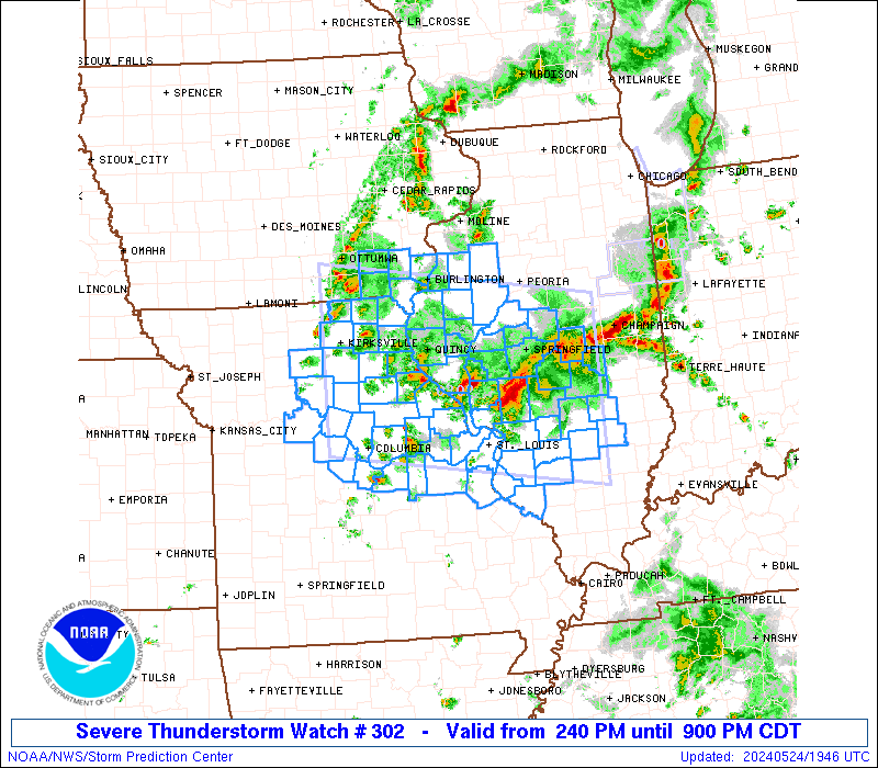
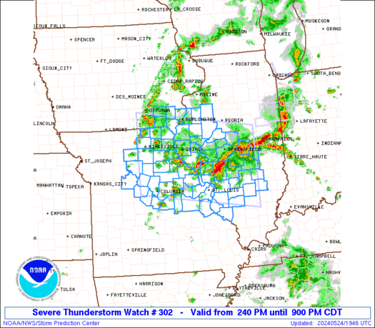
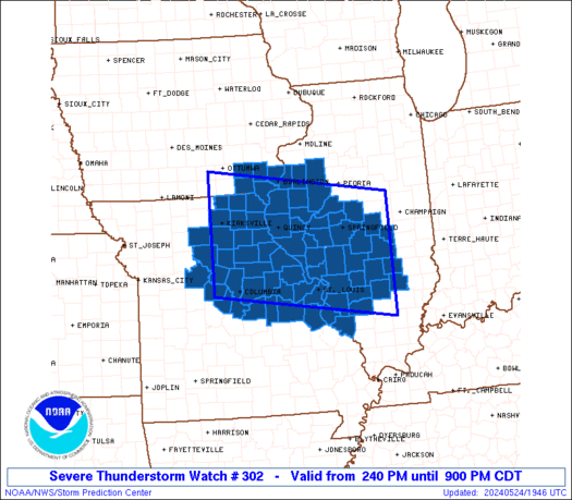
Severe Thunderstorm Watch Number 302
NWS Storm Prediction Center Norman OK
240 PM CDT Fri May 24 2024
The NWS Storm Prediction Center has issued a
* Severe Thunderstorm Watch for portions of
Southeast Iowa
Western and Southern Illinois
Northern and Eastern Missouri
* Effective this Friday afternoon and evening from 240 PM until
900 PM CDT.
* Primary threats include...
Scattered large hail and isolated very large hail events to 2
inches in diameter possible
Scattered damaging wind gusts to 70 mph possible
A tornado or two possible
SUMMARY...Scattered strong to severe thunderstorms will continue to
develop across the region in vicinity of multiple boundaries, with
bouts of large hail and damaging winds as the primary hazards.
The severe thunderstorm watch area is approximately along and 80
statute miles north and south of a line from 20 miles southwest of
Kirksville MO to 40 miles south southeast of Decatur IL. For a
complete depiction of the watch see the associated watch outline
update (WOUS64 KWNS WOU2).
PRECAUTIONARY/PREPAREDNESS ACTIONS...
REMEMBER...A Severe Thunderstorm Watch means conditions are
favorable for severe thunderstorms in and close to the watch area.
Persons in these areas should be on the lookout for threatening
weather conditions and listen for later statements and possible
warnings. Severe thunderstorms can and occasionally do produce
tornadoes.
&&
AVIATION...A few severe thunderstorms with hail surface and aloft to
2 inches. Extreme turbulence and surface wind gusts to 60 knots. A
few cumulonimbi with maximum tops to 500. Mean storm motion vector
25025.
...Guyer
   SEL2

   URGENT - IMMEDIATE BROADCAST REQUESTED
   Severe Thunderstorm Watch Number 302
   NWS Storm Prediction Center Norman OK
   240 PM CDT Fri May 24 2024

   The NWS Storm Prediction Center has issued a

   * Severe Thunderstorm Watch for portions of
     Southeast Iowa
     Western and Southern Illinois
     Northern and Eastern Missouri

   * Effective this Friday afternoon and evening from 240 PM until
     900 PM CDT.

   * Primary threats include...
     Scattered large hail and isolated very large hail events to 2
       inches in diameter possible
     Scattered damaging wind gusts to 70 mph possible
     A tornado or two possible

   SUMMARY...Scattered strong to severe thunderstorms will continue to
   develop across the region in vicinity of multiple boundaries, with
   bouts of large hail and damaging winds as the primary hazards.

   The severe thunderstorm watch area is approximately along and 80
   statute miles north and south of a line from 20 miles southwest of
   Kirksville MO to 40 miles south southeast of Decatur IL. For a
   complete depiction of the watch see the associated watch outline
   update (WOUS64 KWNS WOU2).

   PRECAUTIONARY/PREPAREDNESS ACTIONS...

   REMEMBER...A Severe Thunderstorm Watch means conditions are
   favorable for severe thunderstorms in and close to the watch area.
   Persons in these areas should be on the lookout for threatening
   weather conditions and listen for later statements and possible
   warnings. Severe thunderstorms can and occasionally do produce
   tornadoes.

   &&

   AVIATION...A few severe thunderstorms with hail surface and aloft to
   2 inches. Extreme turbulence and surface wind gusts to 60 knots. A
   few cumulonimbi with maximum tops to 500. Mean storm motion vector
   25025.

   ...Guyer
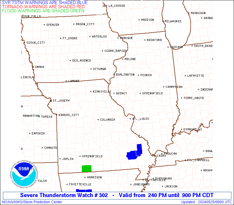
 Note:
The Aviation Watch (SAW) product is an approximation to the watch area.
The actual watch is depicted by the shaded areas.
Note:
The Aviation Watch (SAW) product is an approximation to the watch area.
The actual watch is depicted by the shaded areas.
   SAW2
   WW 302 SEVERE TSTM IA IL MO 241940Z - 250200Z
   AXIS..80 STATUTE MILES NORTH AND SOUTH OF LINE..
   20SW IRK/KIRKSVILLE MO/ - 40SSE DEC/DECATUR IL/
   ..AVIATION COORDS.. 70NM N/S /18SW IRK - 30SSE AXC/
   HAIL SURFACE AND ALOFT..2 INCHES. WIND GUSTS..60 KNOTS.
   MAX TOPS TO 500. MEAN STORM MOTION VECTOR 25025.

   LAT...LON 41059282 40458858 38148858 38749282

   THIS IS AN APPROXIMATION TO THE WATCH AREA.  FOR A
   COMPLETE DEPICTION OF THE WATCH SEE WOUS64 KWNS
   FOR WOU2.
Watch 302 Status Report Messages:
STATUS REPORT #4 ON WW 302

VALID 250045Z - 250140Z

SEVERE WEATHER THREAT CONTINUES RIGHT OF A LINE FROM 15 SW JEF TO
35 E COU TO 50 ENE COU TO 20 S UIN TO 10 ESE UIN TO 35 SW PIA TO
15 SSE PIA TO 15 NW BMI.

..LYONS..05/25/24

ATTN...WFO...DVN...LSX...ILX...EAX...

&&

STATUS REPORT FOR WS 302

SEVERE WEATHER THREAT CONTINUES FOR THE FOLLOWING AREAS

ILC005-009-013-017-021-025-027-049-051-061-083-107-115-117-119-
121-125-129-133-135-137-139-149-157-163-167-171-173-189-
250140-

IL
.    ILLINOIS COUNTIES INCLUDED ARE

BOND		     BROWN		 CALHOUN
CASS		     CHRISTIAN		 CLAY
CLINTON 	     EFFINGHAM		 FAYETTE
GREENE		     JERSEY		 LOGAN
MACON		     MACOUPIN		 MADISON
MARION		     MASON		 MENARD
MONROE		     MONTGOMERY 	 MORGAN
MOULTRIE	     PIKE		 RANDOLPH
ST. CLAIR	     SANGAMON		 SCOTT
SHELBY		     WASHINGTON
$$


MOC055-071-073-093-099-113-123-139-151-163-179-183-186-187-189-
219-221-510-250140-

MO
.    MISSOURI COUNTIES INCLUDED ARE

CRAWFORD	     FRANKLIN		 GASCONADE
IRON		     JEFFERSON		 LINCOLN
MADISON 	     MONTGOMERY 	 OSAGE
PIKE		     REYNOLDS		 ST. CHARLES
STE. GENEVIEVE	     ST. FRANCOIS	 ST. LOUIS
WARREN		     WASHINGTON


MISSOURI INDEPENDENT CITIES INCLUDED ARE

ST. LOUIS CITY
$$


THE WATCH STATUS MESSAGE IS FOR GUIDANCE PURPOSES ONLY.  PLEASE
REFER TO WATCH COUNTY NOTIFICATION STATEMENTS FOR OFFICIAL
INFORMATION ON COUNTIES...INDEPENDENT CITIES AND MARINE ZONES
CLEARED FROM SEVERE THUNDERSTORM AND TORNADO WATCHES.
$$

STATUS REPORT #3 ON WW 302

VALID 242325Z - 250040Z

SEVERE WEATHER THREAT CONTINUES RIGHT OF A LINE FROM 25 WSW COU
TO 40 NE COU TO 5 NE UIN TO 30 WSW MLI.

..LYONS..05/24/24

ATTN...WFO...DVN...LSX...ILX...EAX...

&&

STATUS REPORT FOR WS 302

SEVERE WEATHER THREAT CONTINUES FOR THE FOLLOWING AREAS

ILC001-005-009-013-017-021-025-027-049-051-057-061-067-071-083-
095-107-109-115-117-119-121-125-129-133-135-137-139-149-157-163-
167-169-171-173-187-189-250040-

IL
.    ILLINOIS COUNTIES INCLUDED ARE

ADAMS		     BOND		 BROWN
CALHOUN 	     CASS		 CHRISTIAN
CLAY		     CLINTON		 EFFINGHAM
FAYETTE 	     FULTON		 GREENE
HANCOCK 	     HENDERSON		 JERSEY
KNOX		     LOGAN		 MCDONOUGH
MACON		     MACOUPIN		 MADISON
MARION		     MASON		 MENARD
MONROE		     MONTGOMERY 	 MORGAN
MOULTRIE	     PIKE		 RANDOLPH
ST. CLAIR	     SANGAMON		 SCHUYLER
SCOTT		     SHELBY		 WARREN
WASHINGTON
$$


IAC057-250040-

IA
.    IOWA COUNTIES INCLUDED ARE

DES MOINES
$$


MOC007-027-051-055-071-073-093-099-113-123-135-139-151-163-173-
179-183-186-187-189-219-221-510-250040-

MO
.    MISSOURI COUNTIES INCLUDED ARE

AUDRAIN 	     CALLAWAY		 COLE
CRAWFORD	     FRANKLIN		 GASCONADE
IRON		     JEFFERSON		 LINCOLN
MADISON 	     MONITEAU		 MONTGOMERY
OSAGE		     PIKE		 RALLS
REYNOLDS	     ST. CHARLES	 STE. GENEVIEVE
ST. FRANCOIS	     ST. LOUIS		 WARREN
WASHINGTON


MISSOURI INDEPENDENT CITIES INCLUDED ARE

ST. LOUIS CITY
$$


THE WATCH STATUS MESSAGE IS FOR GUIDANCE PURPOSES ONLY.  PLEASE
REFER TO WATCH COUNTY NOTIFICATION STATEMENTS FOR OFFICIAL
INFORMATION ON COUNTIES...INDEPENDENT CITIES AND MARINE ZONES
CLEARED FROM SEVERE THUNDERSTORM AND TORNADO WATCHES.
$$

STATUS REPORT #2 ON WW 302

VALID 242200Z - 242340Z

SEVERE WEATHER THREAT CONTINUES RIGHT OF A LINE FROM 25 ENE SZL
TO 45 NNW COU TO 35 E IRK TO 40 SW BRL TO 35 NNW BRL.

..LYONS..05/24/24

ATTN...WFO...DVN...LSX...ILX...EAX...

&&

STATUS REPORT FOR WS 302

SEVERE WEATHER THREAT CONTINUES FOR THE FOLLOWING AREAS

ILC001-005-009-013-017-021-025-027-049-051-057-061-067-071-083-
095-107-109-115-117-119-121-125-129-133-135-137-139-149-157-163-
167-169-171-173-187-189-242340-

IL
.    ILLINOIS COUNTIES INCLUDED ARE

ADAMS		     BOND		 BROWN
CALHOUN 	     CASS		 CHRISTIAN
CLAY		     CLINTON		 EFFINGHAM
FAYETTE 	     FULTON		 GREENE
HANCOCK 	     HENDERSON		 JERSEY
KNOX		     LOGAN		 MCDONOUGH
MACON		     MACOUPIN		 MADISON
MARION		     MASON		 MENARD
MONROE		     MONTGOMERY 	 MORGAN
MOULTRIE	     PIKE		 RANDOLPH
ST. CLAIR	     SANGAMON		 SCHUYLER
SCOTT		     SHELBY		 WARREN
WASHINGTON
$$


IAC057-087-111-242340-

IA
.    IOWA COUNTIES INCLUDED ARE

DES MOINES	     HENRY		 LEE
$$


MOC007-019-027-051-055-071-073-093-099-111-113-123-127-135-137-
139-151-163-173-179-183-186-187-189-205-219-221-510-242340-

MO
.    MISSOURI COUNTIES INCLUDED ARE

AUDRAIN 	     BOONE		 CALLAWAY
COLE		     CRAWFORD		 FRANKLIN
GASCONADE	     IRON		 JEFFERSON
LEWIS		     LINCOLN		 MADISON
MARION		     MONITEAU		 MONROE
MONTGOMERY	     OSAGE		 PIKE
RALLS		     REYNOLDS		 ST. CHARLES
STE. GENEVIEVE	     ST. FRANCOIS	 ST. LOUIS
SHELBY		     WARREN		 WASHINGTON


MISSOURI INDEPENDENT CITIES INCLUDED ARE

ST. LOUIS CITY
$$


THE WATCH STATUS MESSAGE IS FOR GUIDANCE PURPOSES ONLY.  PLEASE
REFER TO WATCH COUNTY NOTIFICATION STATEMENTS FOR OFFICIAL
INFORMATION ON COUNTIES...INDEPENDENT CITIES AND MARINE ZONES
CLEARED FROM SEVERE THUNDERSTORM AND TORNADO WATCHES.
$$

STATUS REPORT #1 ON WW 302

VALID 242010Z - 242140Z

THE SEVERE WEATHER THREAT CONTINUES ACROSS THE ENTIRE WATCH AREA.

..LYONS..05/24/24

ATTN...WFO...DVN...LSX...ILX...EAX...

&&

STATUS REPORT FOR WS 302

SEVERE WEATHER THREAT CONTINUES FOR THE FOLLOWING AREAS

ILC001-005-009-013-017-021-025-027-049-051-057-061-067-071-083-
095-107-109-115-117-119-121-125-129-133-135-137-139-149-157-163-
167-169-171-173-187-189-242140-

IL
.    ILLINOIS COUNTIES INCLUDED ARE

ADAMS		     BOND		 BROWN
CALHOUN 	     CASS		 CHRISTIAN
CLAY		     CLINTON		 EFFINGHAM
FAYETTE 	     FULTON		 GREENE
HANCOCK 	     HENDERSON		 JERSEY
KNOX		     LOGAN		 MCDONOUGH
MACON		     MACOUPIN		 MADISON
MARION		     MASON		 MENARD
MONROE		     MONTGOMERY 	 MORGAN
MOULTRIE	     PIKE		 RANDOLPH
ST. CLAIR	     SANGAMON		 SCHUYLER
SCOTT		     SHELBY		 WARREN
WASHINGTON
$$


IAC057-087-101-111-177-242140-

IA
.    IOWA COUNTIES INCLUDED ARE

DES MOINES	     HENRY		 JEFFERSON
LEE		     VAN BUREN
$$


MOC001-007-019-027-041-045-051-053-071-073-089-099-103-111-113-
115-121-127-135-137-139-151-163-173-175-183-189-195-197-199-205-
219-510-242140-

MO
.    MISSOURI COUNTIES INCLUDED ARE

ADAIR		     AUDRAIN		 BOONE
CALLAWAY	     CHARITON		 CLARK
COLE		     COOPER		 FRANKLIN
GASCONADE	     HOWARD		 JEFFERSON
KNOX		     LEWIS		 LINCOLN
LINN		     MACON		 MARION
MONITEAU	     MONROE		 MONTGOMERY
OSAGE		     PIKE		 RALLS
RANDOLPH	     ST. CHARLES	 ST. LOUIS
SALINE		     SCHUYLER		 SCOTLAND
SHELBY		     WARREN


MISSOURI INDEPENDENT CITIES INCLUDED ARE

ST. LOUIS CITY
$$


THE WATCH STATUS MESSAGE IS FOR GUIDANCE PURPOSES ONLY.  PLEASE
REFER TO WATCH COUNTY NOTIFICATION STATEMENTS FOR OFFICIAL
INFORMATION ON COUNTIES...INDEPENDENT CITIES AND MARINE ZONES
CLEARED FROM SEVERE THUNDERSTORM AND TORNADO WATCHES.
$$
Note:
Click for Complete Product Text.
Tornadoes
Probability of 2 or more tornadoes
|
Low (20%)
|
Probability of 1 or more strong (EF2-EF5) tornadoes
|
Low (10%)
|
Wind
Probability of 10 or more severe wind events
|
Mod (50%)
|
Probability of 1 or more wind events > 65 knots
|
Low (20%)
|
Hail
Probability of 10 or more severe hail events
|
Mod (50%)
|
Probability of 1 or more hailstones > 2 inches
|
Mod (30%)
|
Combined Severe Hail/Wind
Probability of 6 or more combined severe hail/wind events
|
High (90%)
|
For each watch, probabilities for particular events inside the watch
(listed above in each table) are determined by the issuing forecaster.
The "Low" category contains probability values ranging from less than 2%
to 20% (EF2-EF5 tornadoes), less than 5% to 20% (all other probabilities),
"Moderate" from 30% to 60%, and "High" from 70% to greater than 95%.
High values are bolded and lighter in color to provide awareness of
an increased threat for a particular event.


 @NWSSPC