|
| Mesoscale Discussion 946 |
|
< Previous MD Next MD >
|
|
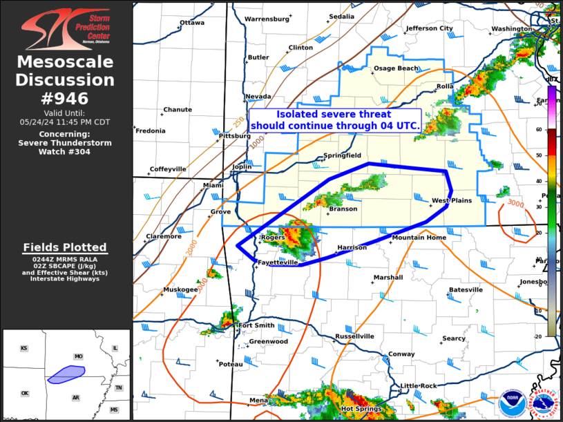
   Mesoscale Discussion 0946
   NWS Storm Prediction Center Norman OK
   0946 PM CDT Fri May 24 2024

   Areas affected...Southern Missouri and far northwest Arkansas

   Concerning...Severe Thunderstorm Watch 304...

   Valid 250246Z - 250445Z

   The severe weather threat for Severe Thunderstorm Watch 304
   continues.

   SUMMARY...Isolated thunderstorms will continue along a cold front
   across south-central Missouri and along the MO/AR border for the
   next 1-2 hours. These storms may periodically intensify to severe
   limits and pose a large hail/damaging wind threat.

   DISCUSSION...Isolated thunderstorms continue to develop along a cold
   front as it migrates into south-central MO. Although the observed 00
   UTC SGF sounding sampled an very supportive environment for severe
   convection (MLCAPE nearly 3000 J/kg with a 0-6 km BWD value of 45
   knots), convection has largely struggled to maintain intensity,
   likely owing to a combination of diminishing forcing for ascent
   along the front and the onset of nocturnal stabilization.  However,
   a few stronger updraft pulses have been noted over the past 30
   minutes and have intensified to severe limits based on MRMS vertical
   ice and MESH estimates. Given weak ascent within an otherwise
   favorable environment, the expectation through 04 UTC is for
   continued development of weak convection with occasional stronger
   updraft pulses that may intensify to severe limits. Unless a more
   robust cell can develop some degree of mid-level rotation and/or a
   sufficiently intense cold pool, storm longevity should be limited.
   Consequently, the severe hail/wind threat should remain somewhat
   isolated as storms move into south-central MO and along the MO/AR
   border.

   ..Moore.. 05/25/2024

   ...Please see www.spc.noaa.gov for graphic product...

   ATTN...WFO...LZK...SGF...TSA...

   LAT...LON   36289441 37009320 37179266 37139211 37099164 36879156
               36719163 36559191 36359258 36169321 36089356 36099395
               36149419 36289441
|
|
Top/All Mesoscale Discussions/Forecast Products/Home
|
|


 @NWSSPC